Bridge Statistics for Alderwood Manor, Washington (WA)
Condition, Traffic, Stress, Structural Evaluation, Project Costs
- National Bridge Inventory (NBI) Statistics
- 17Number of bridges
- 243ft / 73.5mTotal length
- $61,881,000Total costs
- 661,971Total average daily traffic
- 36,703Total average daily truck traffic
- National Bridge Inventory (NBI) Registered Bridges for Alderwood Manor
- No street view available for this location
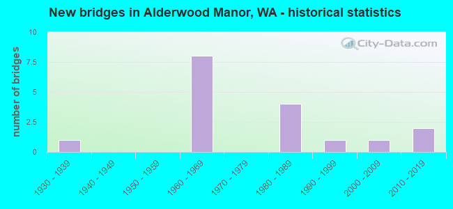
- New bridges - historical statistics
- 11930-1939
- 81960-1969
- 41980-1989
- 11990-1999
- 12000-2009
- 22010-2019

- Reconstructed bridges - Historical Statistics
- 11980-1989
- 41990-1999


- Bridge Condition - Deck
- 15.4%Very good
- 53.8%Good
- 30.8%Satisfactory

- Bridge Condition - Superstructure
- 7.7%Very good
- 69.2%Good
- 23.1%Satisfactory

- Bridge Condition - Substructure
- 23.1%Very good
- 46.2%Good
- 15.4%Satisfactory
- 7.7%Fair
- 7.7%Poor

- Bridge Condition - Channel
- 20.0%Very good
- 40.0%Good
- 40.0%Satisfactory
Find on map >> Show street view
Structure Number: 7134A, Location: 1.1 N JCT SR 524 (Lat: 47.830944, Lng: -122.262417), Route carried "on" structure: Interstate 5, Year Built: 1964, Year Reconstructed: 1995, Status: Open, Structure Length: 8.35m (27.40ft), Average Daily Traffic: 79,517 (year 2019), Truck Traffic: 6%, Average Future Daily Traffic: 115,140 (year 2039), Design Load: HS 20, Features Intersected: I-405 & RAMPS
Minimum Vertical Clearance: 30+ m (98+ ft), Kilometerpoint: 293.818, Lanes on structure: 4, Lanes under structure: 4, Base Highway Network: Yes, Owner: State Highway Agency, Approaching Roadway Width: 20.7m (67.9ft), Skew: 5 degrees, Material/Design: Prestressed concrete, Design/Construction: Stringer/Multi-beam, Number Of Spans In Main Unit: 3, Length of Maximum Span: 28.3m (92.8ft), Curb-To-Curb Width: 20.7m (67.9ft), Out-to-Out Width: 21.6m (70.9ft)
Condition: Deck: Good, Superstructure: Good, Substructure: Good, Operating Rating: 72.6 metric tons, Method Used To Determine Operating Rating: Load Factor (LF), Inventory Rating: 42.6 metric tons, Method Used To Determine Inventory Rating: Load Factor (LF), Structural Evaluation: Better than present minimum criteria, Deck Geometry: Equal to present minimum criteria, Underclear: Equal to present minimum criteria, Approach Roadway Alignment: Equal to present desirable criteria, Length Of Structure Improvement: 8.35m (27.40ft), Designated Inspection Frequency: Every 48 months, Inspection Date: March 2018, Bridge Improvement Cost: $3,836,000, Roadway Improvement Cost: $767,000, Total Project Cost: $7,672,000 ( Estimate for 2014), Deck Structure Type: Concrete Cast-file-Place, Wearing Surface/Protective System: Wearing Surface: Latex Concrete
Find on map >> Show street view
Structure Number: 8417D, Location: 2.2 N JCT SR 527 (Lat: 47.819889, Lng: -122.242222), Route carried "on" structure: Interstate 405, Year Built: 1968, Year Reconstructed: 2001, Status: Open, Structure Length: 5.70m (18.70ft), Average Daily Traffic: 64,767 (year 2019), Truck Traffic: 5%, Average Future Daily Traffic: 93,782 (year 2039), Design Load: HS 20+Mod, Features Intersected: DAMSON RD
Minimum Vertical Clearance: 30+ m (98+ ft), Kilometerpoint: 46.671, Lanes on structure: 4, Lanes under structure: 2, Base Highway Network: Yes, Owner: State Highway Agency, Approaching Roadway Width: 20.4m (66.9ft), Skew: 2 degrees, Material/Design: Prestressed concrete continuous, Design/Construction: Stringer/Multi-beam, Number Of Spans In Main Unit: 3, Length of Maximum Span: 21.6m (70.9ft), Curb-To-Curb Width: 20.4m (66.9ft), Out-to-Out Width: 21.2m (69.6ft)
Condition: Deck: Satisfactory, Superstructure: Satisfactory, Substructure: Good, Operating Rating: 68.0 metric tons, Method Used To Determine Operating Rating: Load Factor (LF), Inventory Rating: 39.9 metric tons, Method Used To Determine Inventory Rating: Load Factor (LF), Structural Evaluation: Equal to present minimum criteria, Deck Geometry: Equal to present minimum criteria, Underclear: Equal to present minimum criteria, Approach Roadway Alignment: Equal to present desirable criteria, Length Of Structure Improvement: 5.70m (18.70ft), Designated Inspection Frequency: Every 24 months, Inspection Date: August 2021, Bridge Improvement Cost: $2,580,000, Roadway Improvement Cost: $516,000, Total Project Cost: $5,161,000 ( Estimate for 2014), Deck Structure Type: Concrete Cast-file-Place, Wearing Surface/Protective System: Wearing Surface: Bituminous
Find on map >> Show street view
Structure Number: 11598B, Location: 2.9 N JCT SR 527 (Lat: 47.825111, Lng: -122.253722), Route carried "on" structure: Interstate 405, Year Built: 1968, Year Reconstructed: 2001, Status: Open, Structure Length: 10.30m (33.79ft), Average Daily Traffic: 64,767 (year 2019), Truck Traffic: 5%, Average Future Daily Traffic: 93,782 (year 2039), Design Load: HS 20+Mod, Features Intersected: SR 524 (FILBERT RD)
Minimum Vertical Clearance: 30+ m (98+ ft), Kilometerpoint: 47.717, Lanes on structure: 5, Lanes under structure: 2, Base Highway Network: Yes, Owner: State Highway Agency, Approaching Roadway Width: 24.1m (79.1ft), Material/Design: Concrete continuous, Design/Construction: Box Beam or Girders - Multiple, Number Of Spans In Main Unit: 3, Length of Maximum Span: 41.1m (134.8ft), Curb-To-Curb Width: 24.1m (79.1ft), Out-to-Out Width: 25.1m (82.3ft)
Condition: Deck: Good, Superstructure: Good, Substructure: Good, Channel: Very good, Operating Rating: 47.2 metric tons, Method Used To Determine Operating Rating: Load Factor (LF), Inventory Rating: 28.1 metric tons, Method Used To Determine Inventory Rating: Load Factor (LF), Structural Evaluation: Better than present minimum criteria, Deck Geometry: Equal to present minimum criteria, Underclear: Better than present minimum criteria, Waterway Adequacy: Equal to present desirable criteria, Approach Roadway Alignment: Equal to present desirable criteria, Length Of Structure Improvement: 10.30m (33.79ft), Designated Inspection Frequency: Every 48 months, Inspection Date: June 2018, Bridge Improvement Cost: $5,476,000, Roadway Improvement Cost: $1,095,000, Total Project Cost: $10,951,000 ( Estimate for 2014), Deck Structure Type: Concrete Cast-file-Place, Wearing Surface/Protective System: Wearing Surface: Bituminous, Membrane: Preformed Fabric
Find on map >> Show street view
Structure Number: 11855A, Location: 3.3 N JCT SR 527 (Lat: 47.831333, Lng: -122.261556), Route carried "on" structure: Interstate 405, Year Built: 1981, Status: Open, Structure Length: 17.07m (56.00ft), Average Daily Traffic: 18,923 (year 2019), Truck Traffic: 5%, Average Future Daily Traffic: 27,400 (year 2039), Design Load: HS 20+Mod, Features Intersected: I-5
Minimum Vertical Clearance: 30+ m (98+ ft), Kilometerpoint: 48.618, Lanes on structure: 3, Lanes under structure: 11, Base Highway Network: Yes, Owner: State Highway Agency, Approaching Roadway Width: 15.8m (51.8ft), Material/Design: Steel continuous, Design/Construction: Stringer/Multi-beam, Number Of Spans In Main Unit: 4, Length of Maximum Span: 50.3m (165.0ft), Curb-To-Curb Width: 15.8m (51.8ft), Out-to-Out Width: 16.8m (55.1ft)
Condition: Deck: Good, Superstructure: Good, Substructure: Good, Operating Rating: 62.6 metric tons, Method Used To Determine Operating Rating: Load Factor (LF), Inventory Rating: 37.2 metric tons, Method Used To Determine Inventory Rating: Load Factor (LF), Structural Evaluation: Better than present minimum criteria, Deck Geometry: Somewhat better than minimum adequacy, Underclear: Equal to present minimum criteria, Approach Roadway Alignment: Equal to present desirable criteria, Length Of Structure Improvement: 17.07m (56.00ft), Designated Inspection Frequency: Every 24 months, Critical Feature Inspection Frequency: Every 24 months, Inspection Date: August 2020, Critical Feature Inspection Date: August 2020, Bridge Improvement Cost: $6,048,000, Roadway Improvement Cost: $1,210,000, Total Project Cost: $12,096,000 ( Estimate for 2014), Deck Structure Type: Concrete Cast-file-Place, Wearing Surface/Protective System: Wearing Surface: Monolithic Concrete, Deck Protection: Epoxy Coated Reinforcing
Find on map >> Show street view
Structure Number: 11855C, Location: 3.3 N JCT SR 527 (Lat: 47.831139, Lng: -122.261500), Route carried "on" structure: Interstate 405, Year Built: 1982, Status: Open, Structure Length: 19.69m (64.60ft), Average Daily Traffic: 26,979 (year 2019), Truck Traffic: 5%, Average Future Daily Traffic: 39,065 (year 2039), Design Load: HS 20+Mod, Features Intersected: I-5
Minimum Vertical Clearance: 30+ m (98+ ft), Kilometerpoint: 48.602, Lanes on structure: 2, Lanes under structure: 13, Base Highway Network: Yes, Owner: State Highway Agency, Approaching Roadway Width: 12.2m (40.0ft), Material/Design: Steel continuous, Design/Construction: Stringer/Multi-beam, Number Of Spans In Main Unit: 5, Length of Maximum Span: 43.3m (142.1ft), Curb-To-Curb Width: 12.3m (40.4ft), Out-to-Out Width: 13.2m (43.3ft)
Condition: Deck: Good, Superstructure: Good, Substructure: Good, Operating Rating: 54.4 metric tons, Method Used To Determine Operating Rating: Load Factor (LF), Inventory Rating: 32.7 metric tons, Method Used To Determine Inventory Rating: Load Factor (LF), Structural Evaluation: Better than present minimum criteria, Deck Geometry: Better than present minimum criteria, Underclear: Equal to present desirable criteria, Approach Roadway Alignment: Equal to present desirable criteria, Length Of Structure Improvement: 19.69m (64.60ft), Designated Inspection Frequency: Every 24 months, Critical Feature Inspection Frequency: Every 24 months, Inspection Date: August 2020, Critical Feature Inspection Date: August 2020, Bridge Improvement Cost: $5,426,000, Roadway Improvement Cost: $1,085,000, Total Project Cost: $10,853,000 ( Estimate for 2014), Deck Structure Type: Concrete Cast-file-Place, Wearing Surface/Protective System: Wearing Surface: Monolithic Concrete, Deck Protection: Epoxy Coated Reinforcing
Find on map >> Show street view
Structure Number: 81732, Location: 0.1 W JCT I-405 (Lat: 47.825000, Lng: -122.255556), Route carried "on" structure: State highway 524, Year Built: 1935, Status: Open, Structure Length: 0.94m (3.08ft), Average Daily Traffic: 19,258 (year 2019), Truck Traffic: 2%, Average Future Daily Traffic: 27,885 (year 2039), Design Load: H 20, Features Intersected: SWAMP CREEK
Minimum Vertical Clearance: 30+ m (98+ ft), Kilometerpoint: 10.750, Lanes on structure: 2, Owner: State Highway Agency, Approaching Roadway Width: 7.6m (24.9ft), Material/Design: Wood or Timber, Design/Construction: Stringer/Multi-beam, Number Of Spans In Main Unit: 1, Length of Maximum Span: 8.8m (28.9ft), Curb or Sidewalk Widths: Left: 0.0m, Right: 0.8m (2.6ft), Curb-To-Curb Width: 6.2m (20.3ft), Out-to-Out Width: 7.4m (24.3ft)
Condition: Deck: Good, Superstructure: Good, Substructure: Satisfactory, Channel: Satisfactory, Operating Rating: 47.2 metric tons, Method Used To Determine Operating Rating: Allowable Stress (AS), Inventory Rating: 28.1 metric tons, Method Used To Determine Inventory Rating: Allowable Stress (AS), Structural Evaluation: Equal to present minimum criteria, Deck Geometry: High priority of replacement, Waterway Adequacy: Equal to present desirable criteria, Approach Roadway Alignment: Equal to present desirable criteria, Length Of Structure Improvement: 0.94m (3.08ft), Designated Inspection Frequency: Every 24 months, Inspection Date: August 2021, Bridge Improvement Cost: $168,000, Roadway Improvement Cost: $34,000, Total Project Cost: $335,000 ( Estimate for 2014), Deck Structure Type: Concrete Cast-file-Place, Wearing Surface/Protective System: Wearing Surface: Bituminous
Find on map >> Show street view
Structure Number: 83075, Location: 1.4 SW INT I-405 (Lat: 47.808275, Lng: -122.256044), Route carried "on" structure: County highway 90616, Year Built: 1963, Status: Open, Structure Length: 0.76m (2.49ft), Average Daily Traffic: 10,486 (year 2019), Truck Traffic: 6%, Average Future Daily Traffic: 14,000 (year 2041), Design Load: H 15, Features Intersected: SWAMP CREEK, Facility Carried by Structure: LARCH WAY
Minimum Vertical Clearance: 30+ m (98+ ft), Kilometerpoint: 0.001, Lanes on structure: 2, Owner: County Highway Agency, Approaching Roadway Width: 6.7m (22.0ft), Material/Design: Concrete, Design/Construction: Channel Beam, Number Of Spans In Main Unit: 1, Length of Maximum Span: 7.0m (23.0ft), Curb or Sidewalk Widths: Left: 0.0m, Right: 1.0m (3.3ft), Curb-To-Curb Width: 6.9m (22.6ft), Out-to-Out Width: 7.3m (24.0ft)
Condition: Deck: Good, Superstructure: Good, Substructure: Fair, Channel: Satisfactory, Operating Rating: 53.5 metric tons, Method Used To Determine Operating Rating: Load Factor (LF), Inventory Rating: 31.7 metric tons, Method Used To Determine Inventory Rating: Load Factor (LF), Structural Evaluation: Somewhat better than minimum adequacy, Deck Geometry: High priority of replacement, Waterway Adequacy: Equal to present minimum criteria, Approach Roadway Alignment: Equal to present desirable criteria, Length Of Structure Improvement: 1.07m (3.51ft), Designated Inspection Frequency: Every 24 months, Inspection Date: December 2021, Bridge Improvement Cost: $532,000, Roadway Improvement Cost: $106,000, Total Project Cost: $1,064,000 ( Estimate for 2014), Deck Structure Type: Other, Wearing Surface/Protective System: Wearing Surface: Bituminous
Find on map >> Show street view
Structure Number: 83504, Location: 1.1 N KING CO LINE (Lat: 47.792344, Lng: -122.255981), Route carried "on" structure: County highway 90136, Year Built: 1960, Year Reconstructed: 1988, Status: Posted for load, Structure Length: 1.25m (4.10ft), Average Daily Traffic: 10,203 (year 2018), Truck Traffic: 7%, Average Future Daily Traffic: 15,000 (year 2040), Design Load: H 15, Features Intersected: SWAMP CREEK, Facility Carried by Structure: LOCUST WAY
Minimum Vertical Clearance: 30+ m (98+ ft), Kilometerpoint: 0.001, Lanes on structure: 2, Owner: County Highway Agency, Approaching Roadway Width: 6.7m (22.0ft), Material/Design: Concrete, Design/Construction: Channel Beam, Number Of Spans In Main Unit: 2, Length of Maximum Span: 6.1m (20.0ft), Curb-To-Curb Width: 6.9m (22.6ft), Out-to-Out Width: 7.3m (24.0ft)
Condition: Deck: Satisfactory, Superstructure: Satisfactory, Substructure: Poor, Channel: Satisfactory, Operating Rating: 20.9 metric tons, Method Used To Determine Operating Rating: Allowable Stress (AS), Inventory Rating: 15.4 metric tons, Method Used To Determine Inventory Rating: Allowable Stress (AS), Structural Evaluation: High priority of replacement, Deck Geometry: High priority of replacement, Waterway Adequacy: Equal to present desirable criteria, Approach Roadway Alignment: Equal to present minimum criteria, Bridge Posting: Required (Relationship of Operating Rating to Maximum Legal Load: 20.0 - 29.9% below), Length Of Structure Improvement: 1.55m (5.09ft), Designated Inspection Frequency: Every 24 months, Inspection Date: October 2020, Bridge Improvement Cost: $775,000, Roadway Improvement Cost: $155,000, Total Project Cost: $1,550,000 ( Estimate for 2014), Deck Structure Type: Other, Wearing Surface/Protective System: Wearing Surface: Bituminous
Find on map >> Show street view
Structure Number: 84727, Location: 0.02 N KING CO LIN (Lat: 47.777236, Lng: -122.249858), Route carried "on" structure: County highway 6490, Year Built: 1968, Status: Open, Structure Length: 1.22m (4.00ft), Average Daily Traffic: 4,739 (year 2018), Truck Traffic: 5%, Average Future Daily Traffic: 7,500 (year 2041), Features Intersected: SWAMP CREEK, Facility Carried by Structure: LOCKWOOD RD
Minimum Vertical Clearance: 30+ m (98+ ft), Kilometerpoint: 0.001, Lanes on structure: 2, Owner: County Highway Agency, Approaching Roadway Width: 8.5m (27.9ft), Material/Design: Prestressed concrete, Design/Construction: Tee Beam, Number Of Spans In Main Unit: 1, Length of Maximum Span: 11.9m (39.0ft), Curb-To-Curb Width: 8.0m (26.2ft), Out-to-Out Width: 8.5m (27.9ft)
Condition: Deck: Satisfactory, Superstructure: Satisfactory, Substructure: Satisfactory, Channel: Good, Operating Rating: 39.9 metric tons, Method Used To Determine Operating Rating: Load Factor (LF), Inventory Rating: 24.5 metric tons, Method Used To Determine Inventory Rating: Load Factor (LF), Structural Evaluation: Equal to present minimum criteria, Deck Geometry: High priority of corrective action, Waterway Adequacy: Equal to present desirable criteria, Approach Roadway Alignment: Equal to present desirable criteria, Length Of Structure Improvement: 1.52m (4.99ft), Designated Inspection Frequency: Every 24 months, Inspection Date: October 2021, Bridge Improvement Cost: $760,000, Roadway Improvement Cost: $152,000, Total Project Cost: $1,520,000 ( Estimate for 2014), Deck Structure Type: Other, Wearing Surface/Protective System: Wearing Surface: Bituminous
Find on map >> Show street view
Structure Number: 86034, Location: 1.9 N KING CO LINE (Lat: 47.798806, Lng: -122.254728), Route carried "on" structure: County highway 90136, Year Built: 1993, Status: Open, Structure Length: 1.68m (5.51ft), Average Daily Traffic: 3,514 (year 2019), Truck Traffic: 6%, Average Future Daily Traffic: 6,000 (year 2042), Design Load: HS 20, Features Intersected: SWAMP CREEK, Facility Carried by Structure: LOCUST WAY
Minimum Vertical Clearance: 30+ m (98+ ft), Kilometerpoint: 0.001, Lanes on structure: 2, Owner: County Highway Agency, Approaching Roadway Width: 11.9m (39.0ft), Skew: 4 degrees, Material/Design: Prestressed concrete, Design/Construction: Stringer/Multi-beam, Number Of Spans In Main Unit: 1, Length of Maximum Span: 15.2m (49.9ft), Curb or Sidewalk Widths: Left: 1.5m (4.9ft), Right: 1.5m (4.9ft), Curb-To-Curb Width: 9.1m (29.9ft), Out-to-Out Width: 12.7m (41.7ft)
Condition: Deck: Satisfactory, Superstructure: Good, Substructure: Good, Channel: Satisfactory, Operating Rating: 59.0 metric tons, Method Used To Determine Operating Rating: Load Factor (LF), Inventory Rating: 35.4 metric tons, Method Used To Determine Inventory Rating: Load Factor (LF), Structural Evaluation: Better than present minimum criteria, Deck Geometry: Meets minimum limits, Waterway Adequacy: Equal to present minimum criteria, Approach Roadway Alignment: Equal to present desirable criteria, Length Of Structure Improvement: 1.98m (6.50ft), Designated Inspection Frequency: Every 24 months, Inspection Date: October 2020, Bridge Improvement Cost: $988,000, Roadway Improvement Cost: $198,000, Total Project Cost: $1,976,000 ( Estimate for 2014), Deck Structure Type: Concrete Cast-file-Place, Wearing Surface/Protective System: Wearing Surface: Monolithic Concrete, Deck Protection: Epoxy Coated Reinforcing
Find on map >> Show street view
Structure Number: 87029, Location: 1.0 E JCT I-5 (Lat: 47.849897, Lng: -122.266228), Route carried "on" structure: County highway 90561, Year Built: 1960, Year Reconstructed: 2003, Status: Open, Structure Length: 0.70m (2.30ft), Average Daily Traffic: 29,286 (year 2019), Truck Traffic: 8%, Average Future Daily Traffic: 50,000 (year 2041), Design Load: HS 20, Features Intersected: SWAMP CREEK, Facility Carried by Structure: 164TH ST SW
Minimum Vertical Clearance: 30+ m (98+ ft), Kilometerpoint: 0.966, Lanes on structure: 5, Base Highway Network: Yes, Owner: County Highway Agency, Approaching Roadway Width: 19.8m (65.0ft), Skew: 1 degrees, Material/Design: Concrete, Design/Construction: Culvert, Number Of Spans In Main Unit: 1, Length of Maximum Span: 6.7m (22.0ft), Curb or Sidewalk Widths: Left: 2.0m (6.6ft), Right: 2.0m (6.6ft), Curb-To-Curb Width: 19.8m (65.0ft), Out-to-Out Width: 24.6m (80.7ft)
Condition: Channel: Good, Culverts: Satisfactory, Operating Rating: 42.6 metric tons, Method Used To Determine Operating Rating: Field evaluation and documented engineering judgment, Inventory Rating: 32.7 metric tons, Method Used To Determine Inventory Rating: Field evaluation and documented engineering judgment, Structural Evaluation: Equal to present minimum criteria, Deck Geometry: Meets minimum limits, Waterway Adequacy: Somewhat better than minimum adequacy, Approach Roadway Alignment: Equal to present desirable criteria, Length Of Structure Improvement: 1.01m (3.31ft), Designated Inspection Frequency: Every 24 months, Inspection Date: June 2021, Bridge Improvement Cost: $977,000, Roadway Improvement Cost: $195,000, Total Project Cost: $1,954,000 ( Estimate for 2014)
Find on map >> Show street view
Structure Number: 88141, Location: 0.6 SW JCT i-5 (Lat: 47.845319, Lng: -122.267336), Route carried "on" structure: County highway 8810, Year Built: 2009, Status: Open, Structure Length: 0.91m (2.99ft), Average Daily Traffic: 8,808 (year 2017), Truck Traffic: 5%, Average Future Daily Traffic: 15,000 (year 2041), Design Load: HL 93, Features Intersected: Swamp Creek, Facility Carried by Structure: Ash Way
Minimum Vertical Clearance: 30+ m (98+ ft), Kilometerpoint: 0.001, Lanes on structure: 2, Owner: County Highway Agency, Approaching Roadway Width: 9.8m (32.2ft), Skew: 1 degrees, Material/Design: Concrete, Design/Construction: Frame, Number Of Spans In Main Unit: 1, Length of Maximum Span: 8.5m (27.9ft), Curb or Sidewalk Widths: Left: 1.7m (5.6ft), Right: 1.7m (5.6ft), Curb-To-Curb Width: 9.8m (32.2ft), Out-to-Out Width: 13.8m (45.3ft)
Condition: Deck: Very good, Superstructure: Good, Substructure: Very good, Channel: Very good, Operating Rating: 64.4 metric tons, Method Used To Determine Operating Rating: Load Factor (LF), Inventory Rating: 38.1 metric tons, Method Used To Determine Inventory Rating: Load Factor (LF), Structural Evaluation: Better than present minimum criteria, Deck Geometry: Meets minimum limits, Waterway Adequacy: Equal to present minimum criteria, Approach Roadway Alignment: Equal to present minimum criteria, Length Of Structure Improvement: 1.22m (4.00ft), Designated Inspection Frequency: Every 24 months, Inspection Date: June 2021, Bridge Improvement Cost: $608,000, Roadway Improvement Cost: $122,000, Total Project Cost: $1,216,000 ( Estimate for 2014), Deck Structure Type: Concrete Precast Panels, Wearing Surface/Protective System: Wearing Surface: Bituminous, Deck Protection: Epoxy Coated Reinforcing
Find on map >> Show street view
Structure Number: 88564, Location: 0.2 N. KING CO. LINE (Lat: 47.779639, Lng: -122.251094), Route carried "on" structure: County highway 6510, Year Built: 2013, Status: Open, Structure Length: 2.80m (9.19ft), Average Daily Traffic: 3,021 (year 2019), Truck Traffic: 5%, Average Future Daily Traffic: 5,000 (year 2043), Design Load: HL 93, Features Intersected: SWAMP CREEK, Facility Carried by Structure: CARTER RD.
Minimum Vertical Clearance: 30+ m (98+ ft), Kilometerpoint: 0.001, Lanes on structure: 2, Owner: County Highway Agency, Approaching Roadway Width: 10.1m (33.1ft), Skew: 2 degrees, Material/Design: Prestressed concrete, Design/Construction: Stringer/Multi-beam, Number Of Spans In Main Unit: 1, Length of Maximum Span: 26.5m (86.9ft), Curb or Sidewalk Widths: Left: 1.7m (5.6ft), Right: 1.7m (5.6ft), Curb-To-Curb Width: 10.1m (33.1ft), Out-to-Out Width: 14.1m (46.3ft)
Condition: Deck: Good, Superstructure: Very good, Substructure: Very good, Channel: Good, Operating Rating: 72.3 metric tons, Method Used To Determine Operating Rating: Load and Resistance Factor Rating (LRFR) rating reported by rating factor(RF) method using HL-93 loadings, Inventory Rating: 55.7 metric tons, Method Used To Determine Inventory Rating: Load and Resistance Factor Rating (LRFR) rating reported by rating factor(RF) method using HL-93 loadings, Structural Evaluation: Equal to present desirable criteria, Deck Geometry: Meets minimum limits, Waterway Adequacy: Equal to present desirable criteria, Approach Roadway Alignment: Equal to present desirable criteria, Length Of Structure Improvement: 3.11m (10.20ft), Designated Inspection Frequency: Every 24 months, Inspection Date: November 2021, Bridge Improvement Cost: $1,550,000, Roadway Improvement Cost: $310,000, Total Project Cost: $3,101,000 ( Estimate for 2014), Deck Structure Type: Concrete Cast-file-Place, Wearing Surface/Protective System: Wearing Surface: Monolithic Concrete, Deck Protection: Galvanized Reinforcing
Find on map >> Show street view
Structure Number: 88914, Location: 0.9 mi north King Co line (Lat: 47.788611, Lng: -122.256111), Route carried "on" structure: County highway 90135, Year Built: 2016, Status: Open, Structure Length: 2.13m (6.99ft), Average Daily Traffic: 11,382 (year 2018), Truck Traffic: 5%, Average Future Daily Traffic: 15,000 (year 2039), Design Load: HL 93, Features Intersected: Swamp Creek, Facility Carried by Structure: Locust Way
Minimum Vertical Clearance: 30+ m (98+ ft), Kilometerpoint: 0.001, Lanes on structure: 2, Owner: County Highway Agency, Approaching Roadway Width: 7.9m (25.9ft), Material/Design: Prestressed concrete, Design/Construction: Tee Beam, Number Of Spans In Main Unit: 1, Length of Maximum Span: 19.5m (64.0ft), Curb or Sidewalk Widths: Left: 1.8m (5.9ft), Right: 1.8m (5.9ft), Curb-To-Curb Width: 9.8m (32.2ft), Out-to-Out Width: 14.3m (46.9ft)
Condition: Deck: Very good, Superstructure: Good, Substructure: Very good, Channel: Good, Operating Rating: 64.2 metric tons, Method Used To Determine Operating Rating: Load and Resistance Factor Rating (LRFR) rating reported by rating factor(RF) method using HL-93 loadings, Inventory Rating: 45.0 metric tons, Method Used To Determine Inventory Rating: Load and Resistance Factor Rating (LRFR) rating reported by rating factor(RF) method using HL-93 loadings, Structural Evaluation: Better than present minimum criteria, Deck Geometry: Meets minimum limits, Waterway Adequacy: Equal to present desirable criteria, Approach Roadway Alignment: Equal to present minimum criteria, Length Of Structure Improvement: 2.44m (8.01ft), Designated Inspection Frequency: Every 24 months, Inspection Date: March 2021, Bridge Improvement Cost: $1,216,000, Roadway Improvement Cost: $243,000, Total Project Cost: $2,432,000 ( Estimate for 2014), Deck Structure Type: Concrete Cast-file-Place, Wearing Surface/Protective System: Wearing Surface: Monolithic Concrete, Deck Protection: Galvanized Reinforcing
Find on map >> Show street view
Structure Number: 11598B, Location: JCT I-405 (Lat: 47.825111, Lng: -122.253722), Route carried "under" structure: State highway 524, Year Built: 1968, Structure Length: 0. m, Average Daily Traffic: 22,311 (year 2019), Truck Traffic: 2%, Features Intersected: SR 524 (FILBERT RD), Facility Carried by Structure: I-405
Minimum Vertical Clearance: 17.53m (57.51ft), Kilometerpoint: 10.847, Lanes on structure: 5, Lanes under structure: 2, Material/Design: Concrete continuous, Design/Construction: Box Beam or Girders - Multiple, Length of Maximum Span: 41.1m (134.8ft)
Find on map >> Show street view
Structure Number: 11855A, Location: 1.4 N JCT SR 524 (Lat: 47.831333, Lng: -122.261556), Route carried "under" structure: Interstate 5, Year Built: 1981, Structure Length: 0. m, Average Daily Traffic: 142,005 (year 2019), Truck Traffic: 6%, Features Intersected: I-5
Minimum Vertical Clearance: 6.05m (19.85ft), Kilometerpoint: 293.914, Lanes on structure: 3, Lanes under structure: 11, Material/Design: Steel continuous, Design/Construction: Stringer/Multi-beam, Length of Maximum Span: 50.3m (165.0ft)
Find on map >> Show street view
Structure Number: 11855C, Location: 1.4 N JCT SR 524 (Lat: 47.831139, Lng: -122.261500), Route carried "under" structure: Interstate 5, Year Built: 1982, Structure Length: 0. m, Average Daily Traffic: 142,005 (year 2019), Truck Traffic: 6%, Features Intersected: I-5
Minimum Vertical Clearance: 6.05m (19.85ft), Kilometerpoint: 293.882, Lanes on structure: 2, Lanes under structure: 13, Material/Design: Steel continuous, Design/Construction: Stringer/Multi-beam, Length of Maximum Span: 43.3m (142.1ft)