Bridge Statistics for Albion, New York (NY)
Condition, Traffic, Stress, Structural Evaluation, Project Costs
- National Bridge Inventory (NBI) Statistics
- 11Number of bridges
- 135ft / 40.5mTotal length
- $30,657,000Total costs
- 12,543Total average daily traffic
- 629Total average daily truck traffic
- National Bridge Inventory (NBI) Registered Bridges for Albion
- No street view available for this location
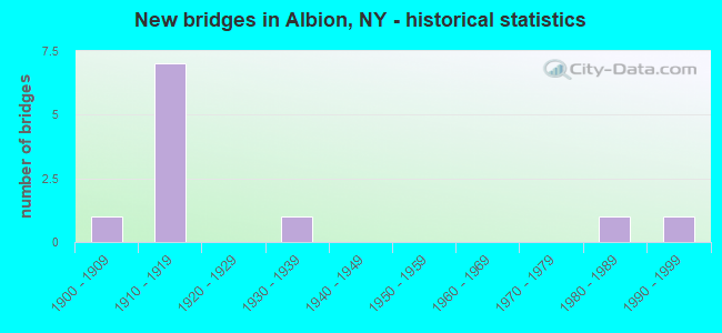
- New bridges - historical statistics
- 11900-1909
- 71910-1919
- 11930-1939
- 11980-1989
- 11990-1999
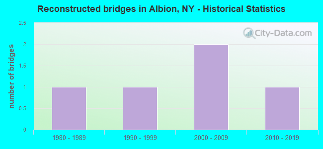
- Reconstructed bridges - Historical Statistics
- 11980-1989
- 11990-1999
- 22000-2009
- 12010-2019
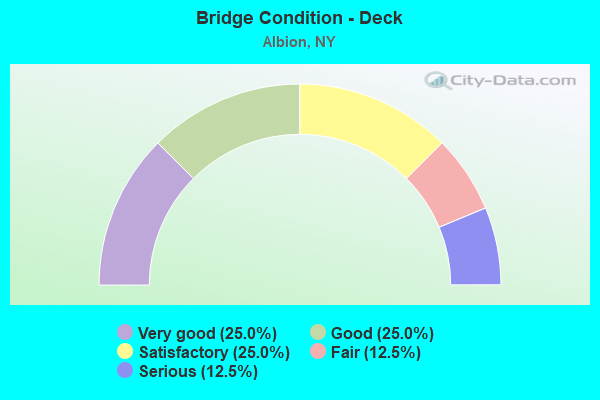
- Bridge Condition - Deck
- 25.0%Very good
- 25.0%Good
- 25.0%Satisfactory
- 12.5%Fair
- 12.5%Serious
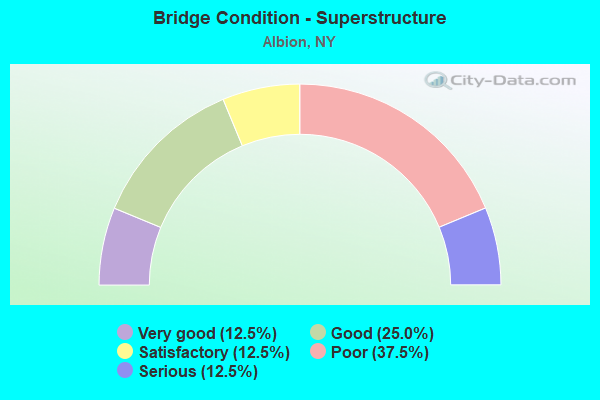
- Bridge Condition - Superstructure
- 12.5%Very good
- 25.0%Good
- 12.5%Satisfactory
- 37.5%Poor
- 12.5%Serious
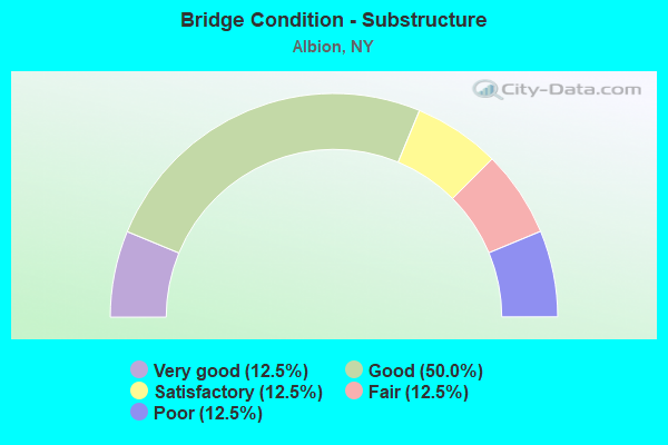
- Bridge Condition - Substructure
- 12.5%Very good
- 50.0%Good
- 12.5%Satisfactory
- 12.5%Fair
- 12.5%Poor
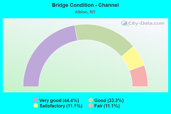
- Bridge Condition - Channel
- 44.4%Very good
- 33.3%Good
- 11.1%Satisfactory
- 11.1%Fair
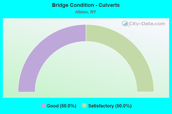
- Bridge Condition - Culverts
- 50.0%Good
- 50.0%Satisfactory
Find on map >> Show street view
Structure Number: 102155, Location: .8 MI E JCT SH 31 & SH 98 (Lat: 43.241286, Lng: -78.178047), Route carried "on" structure: State highway 31, Year Built: 1931, Status: Open, Structure Length: 0.79m (2.59ft), Average Daily Traffic: 3,149 (year 2020), Truck Traffic: 6%, Average Future Daily Traffic: 3,163 (year 2040), Features Intersected: W BR SANDY CREEK
Minimum Vertical Clearance: 30+ m (98+ ft), Kilometerpoint: 25.229, Lanes on structure: 2, Base Highway Network: Yes, Owner: State Highway Agency, Approaching Roadway Width: 12.5m (41.0ft), Skew: 3 degrees, Material/Design: Concrete, Design/Construction: Culvert, Number Of Spans In Main Unit: 1, Length of Maximum Span: 6.4m (21.0ft), Curb or Sidewalk Widths: Left: 1.5m (4.9ft), Right: 2.2m (7.2ft)
Condition: Channel: Satisfactory, Culverts: Satisfactory, Structural Evaluation: Equal to present minimum criteria, Waterway Adequacy: Equal to present desirable criteria, Approach Roadway Alignment: Equal to present desirable criteria, Length Of Structure Improvement: 0.79m (2.59ft), Designated Inspection Frequency: Every 24 months, Inspection Date: September 2021, Bridge Improvement Cost: $569,000, Roadway Improvement Cost: $333,000, Total Project Cost: $902,000 ( Estimate for 2021)
Find on map >> Show street view
Structure Number: 331933, Location: 1.3 MI S EAGLE HARBOR (Lat: 43.233289, Lng: -78.253842), Route carried "on" structure: County highway , Year Built: 1999, Status: Open, Structure Length: 0.88m (2.89ft), Average Daily Traffic: 870 (year 2017), Truck Traffic: 8%, Average Future Daily Traffic: 1,218 (year 2037), Design Load: HS 25 or greater, Features Intersected: OTTER CREEK, Facility Carried by Structure: EAGLE HBR-W BARRE
Minimum Vertical Clearance: 30+ m (98+ ft), Kilometerpoint: 1.625, Lanes on structure: 2, Owner: County Highway Agency, Approaching Roadway Width: 7.3m (24.0ft), Skew: 1 degrees, Material/Design: Concrete, Design/Construction: Frame, Number Of Spans In Main Unit: 1, Length of Maximum Span: 8.5m (27.9ft), Curb-To-Curb Width: 7.8m (25.6ft), Out-to-Out Width: 8.8m (28.9ft)
Condition: Deck: Good, Superstructure: Good, Substructure: Good, Channel: Fair, Operating Rating: 78.7 metric tons, Method Used To Determine Operating Rating: Field evaluation and documented engineering judgment, Inventory Rating: 40.8 metric tons, Method Used To Determine Inventory Rating: Field evaluation and documented engineering judgment, Structural Evaluation: Better than present minimum criteria, Deck Geometry: Meets minimum limits, Waterway Adequacy: Equal to present desirable criteria, Approach Roadway Alignment: Equal to present desirable criteria, Length Of Structure Improvement: 0.88m (2.89ft), Designated Inspection Frequency: Every 24 months, Inspection Date: August 2021, Bridge Improvement Cost: $275,000, Roadway Improvement Cost: $161,000, Total Project Cost: $437,000 ( Estimate for 2021)
Find on map >> Show street view
Structure Number: 336635, Location: 7.4 MI S.EAGLE HABOR (Lat: 43.218686, Lng: -78.250944), Route carried "on" structure: Other road , Year Built: 1986, Status: Open, Structure Length: 0.70m (2.30ft), Average Daily Traffic: 986 (year 2017), Truck Traffic: 9%, Average Future Daily Traffic: 1,380 (year 2037), Design Load: HS 20, Features Intersected: OTTER CREEK, Facility Carried by Structure: W.COUNTY HOUSE RD
Minimum Vertical Clearance: 30+ m (98+ ft), Kilometerpoint: 0.274, Lanes on structure: 2, Owner: County Highway Agency, Approaching Roadway Width: 8.2m (26.9ft), Material/Design: Concrete continuous, Design/Construction: Culvert, Number Of Spans In Main Unit: 2, Length of Maximum Span: 3.0m (9.8ft)
Condition: Channel: Good, Culverts: Good, Operating Rating: 74.8 metric tons, Method Used To Determine Operating Rating: Field evaluation and documented engineering judgment, Inventory Rating: 32.7 metric tons, Method Used To Determine Inventory Rating: Field evaluation and documented engineering judgment, Structural Evaluation: Better than present minimum criteria, Waterway Adequacy: Somewhat better than minimum adequacy, Approach Roadway Alignment: Equal to present desirable criteria, Length Of Structure Improvement: 0.70m (2.30ft), Designated Inspection Frequency: Every 24 months, Inspection Date: October 2020, Bridge Improvement Cost: $103,000, Roadway Improvement Cost: $61,000, Total Project Cost: $164,000 ( Estimate for 2021)
Find on map >> Show street view
Structure Number: 444508, Location: 2.3MI W JCT BARGE C+387 (Lat: 43.249308, Lng: -78.135478), Route carried "on" structure: ServiceCounty highway , Year Built: 1911, Year Reconstructed: 2019, Status: Posted for load-capacity, Structure Length: 5.67m (18.60ft), Average Daily Traffic: 215 (year 2017), Truck Traffic: 10%, Average Future Daily Traffic: 301 (year 2037), Features Intersected: Erie Canal Heritage Trai, Facility Carried by Structure: DENSMORE ROAD
Minimum Vertical Clearance: 4.19m (13.75ft), Kilometerpoint: 0.740, Lanes on structure: 1, Owner: State Highway Agency, Approaching Roadway Width: 6.7m (22.0ft), Navigation Control: Yes ( Vertical Clearance: 4.8m (15.7ft), Horizontal Clearance: 28.6m (93.8ft)), Material/Design: Steel, Design/Construction: Truss - Thru, Number Of Spans In Main Unit: 1, Number Of Approach Spans: 2, Length of Maximum Span: 46.0m (150.9ft), Curb-To-Curb Width: 4.5m (14.8ft), Out-to-Out Width: 4.9m (16.1ft)
Condition: Deck: Very good, Superstructure: Good, Substructure: Very good, Operating Rating: 30.1 metric tons, Method Used To Determine Operating Rating: Load and Resistance Factor Rating (LRFR) rating reported by rating factor(RF) method using HL-93 loadings, Inventory Rating: 23.0 metric tons, Method Used To Determine Inventory Rating: Load and Resistance Factor Rating (LRFR) rating reported by rating factor(RF) method using HL-93 loadings, Structural Evaluation: Equal to present minimum criteria, Deck Geometry: High priority of replacement, Waterway Adequacy: Superior to present desirable criteria, Approach Roadway Alignment: Meets minimum limits, Length Of Structure Improvement: 5.66m (18.57ft), Designated Inspection Frequency: Every 24 months, Critical Feature Inspection Frequency: Every 24 months, Inspection Date: July 2021, Critical Feature Inspection Date: July 2021, Bridge Improvement Cost: $1,987,000, Roadway Improvement Cost: $1,163,000, Total Project Cost: $3,150,000 ( Estimate for 2021), Wearing Surface/Protective System: Wearing Surface: Integral Concrete
Find on map >> Show street view
Structure Number: 444509, Location: 2.3MI E JCT BARGE C+RTE98 (Lat: 43.249208, Lng: -78.149389), Route carried "on" structure: ServiceCounty highway , Year Built: 1912, Year Reconstructed: 2009, Status: Posted for load, Structure Length: 5.88m (19.29ft), Average Daily Traffic: 209 (year 2016), Truck Traffic: 5%, Average Future Daily Traffic: 293 (year 2036), Features Intersected: Erie Canalway Trail, ERI, Facility Carried by Structure: KEITEL ROAD
Minimum Vertical Clearance: 4.24m (13.91ft), Kilometerpoint: 0.772, Lanes on structure: 1, Owner: State Highway Agency, Approaching Roadway Width: 6.7m (22.0ft), Navigation Control: Yes ( Vertical Clearance: 999.9m (3,280.5ft), Horizontal Clearance: 22.9m (75.1ft)), Material/Design: Steel, Design/Construction: Truss - Thru, Number Of Spans In Main Unit: 1, Number Of Approach Spans: 2, Length of Maximum Span: 46.0m (150.9ft), Curb-To-Curb Width: 4.5m (14.8ft), Out-to-Out Width: 5.0m (16.4ft)
Condition: Deck: Satisfactory, Superstructure: Satisfactory, Substructure: Good, Channel: Good, Operating Rating: 22.4 metric tons, Method Used To Determine Operating Rating: Load and Resistance Factor Rating (LRFR) rating reported by rating factor(RF) method using HL-93 loadings, Inventory Rating: 17.5 metric tons, Method Used To Determine Inventory Rating: Load and Resistance Factor Rating (LRFR) rating reported by rating factor(RF) method using HL-93 loadings, Structural Evaluation: Somewhat better than minimum adequacy, Deck Geometry: High priority of replacement, Waterway Adequacy: Superior to present desirable criteria, Approach Roadway Alignment: Meets minimum limits, Bridge Posting: Required (Relationship of Operating Rating to Maximum Legal Load: > 39.9% below), Length Of Structure Improvement: 5.88m (19.29ft), Designated Inspection Frequency: Every 12 months, Critical Feature Inspection Frequency: Every 12 months, Inspection Date: September 2021, Critical Feature Inspection Date: September 2021, Bridge Improvement Cost: $2,485,000, Roadway Improvement Cost: $1,455,000, Total Project Cost: $3,940,000 ( Estimate for 2021), Wearing Surface/Protective System: Wearing Surface: Integral Concrete
Find on map >> Show street view
Structure Number: 44451, Location: 1.4 MI E JCT BRG C & SH98 (Lat: 43.248722, Lng: -78.166031), Route carried "on" structure: Other road , Year Built: 1912, Year Reconstructed: 2004, Status: Posted for load, Structure Length: 5.85m (19.19ft), Average Daily Traffic: 759 (year 2016), Truck Traffic: 2%, Average Future Daily Traffic: 1,063 (year 2036), Features Intersected: Canal Trailway, ERIE CAN, Facility Carried by Structure: BUTTS ROAD
Minimum Vertical Clearance: 4.24m (13.91ft), Kilometerpoint: 0.772, Lanes on structure: 1, Owner: State Highway Agency, Approaching Roadway Width: 6.7m (22.0ft), Navigation Control: Yes ( Vertical Clearance: 999.9m (3,280.5ft), Horizontal Clearance: 22.8m (74.8ft)), Material/Design: Steel, Design/Construction: Truss - Thru, Number Of Spans In Main Unit: 1, Number Of Approach Spans: 2, Length of Maximum Span: 46.0m (150.9ft), Curb-To-Curb Width: 4.5m (14.8ft), Out-to-Out Width: 5.0m (16.4ft)
Condition: Deck: Fair, Superstructure: Poor, Substructure: Good, Channel: Very good, Operating Rating: 39.0 metric tons, Method Used To Determine Operating Rating: Load Factor (LF), Inventory Rating: 22.7 metric tons, Method Used To Determine Inventory Rating: Load Factor (LF), Structural Evaluation: Meets minimum limits, Deck Geometry: High priority of replacement, Waterway Adequacy: Superior to present desirable criteria, Approach Roadway Alignment: Meets minimum limits, Bridge Posting: Required (Relationship of Operating Rating to Maximum Legal Load: > 39.9% below), Length Of Structure Improvement: 5.85m (19.19ft), Designated Inspection Frequency: Every 12 months, Critical Feature Inspection Frequency: Every 12 months, Inspection Date: September 2021, Critical Feature Inspection Date: September 2021, Bridge Improvement Cost: $2,497,000, Roadway Improvement Cost: $1,462,000, Total Project Cost: $3,959,000 ( Estimate for 2021), Wearing Surface/Protective System: Wearing Surface: Integral Concrete
Find on map >> Show street view
Structure Number: 444512, Location: .2 MI E JCT BG CNL & SH98 (Lat: 43.248531, Lng: -78.190422), Route carried "on" structure: Other road , Year Built: 1911, Year Reconstructed: 2007, Status: Open, Structure Length: 4.05m (13.29ft), Average Daily Traffic: 1,192 (year 2020), Truck Traffic: 3%, Average Future Daily Traffic: 1,474 (year 2040), Design Load: H 20, Features Intersected: ERIE CANAL, Facility Carried by Structure: INGERSOLL STREET
Minimum Vertical Clearance: 30+ m (98+ ft), Kilometerpoint: 0.225, Lanes on structure: 1, Owner: State Highway Agency, Approaching Roadway Width: 5.5m (18.0ft), Skew: 1 degrees, Navigation Control: Yes ( Vertical Clearance: 999.9m (3,280.5ft), Horizontal Clearance: 22.9m (75.1ft)), Material/Design: Steel, Design/Construction: Movable - Lift, Number Of Spans In Main Unit: 1, Number Of Approach Spans: 2, Length of Maximum Span: 33.8m (110.9ft), Curb or Sidewalk Widths: Left: 1.8m (5.9ft), Right: 1.8m (5.9ft), Curb-To-Curb Width: 5.7m (18.7ft), Out-to-Out Width: 6.3m (20.7ft)
Condition: Deck: Very good, Superstructure: Very good, Substructure: Good, Channel: Good, Operating Rating: 42.6 metric tons, Method Used To Determine Operating Rating: Load Factor (LF), Inventory Rating: 25.4 metric tons, Method Used To Determine Inventory Rating: Load Factor (LF), Structural Evaluation: Equal to present minimum criteria, Deck Geometry: High priority of replacement, Waterway Adequacy: Equal to present minimum criteria, Approach Roadway Alignment: Somewhat better than minimum adequacy, Length Of Structure Improvement: 4.05m (13.29ft), Designated Inspection Frequency: Every 24 months, Critical Feature Inspection Frequency: Every 24 months, Inspection Date: August 2021, Critical Feature Inspection Date: August 2021, Bridge Improvement Cost: $3,631,000, Roadway Improvement Cost: $2,126,000, Total Project Cost: $5,757,000 ( Estimate for 2021), Deck Structure Type: Concrete Cast-file-Place, Wearing Surface/Protective System: Wearing Surface: Bituminous, Deck Protection: Epoxy Coated Reinforcing
Find on map >> Show street view
Structure Number: 444513, Location: 1 MI W JCT BARGE C & SH98 (Lat: 43.249397, Lng: -78.214794), Route carried "on" structure: ServiceOther road , Year Built: 1911, Status: Posted for load, Structure Length: 6.71m (22.01ft), Average Daily Traffic: 51 (year 2020), Average Future Daily Traffic: 71 (year 2040), Features Intersected: Erie Canalway Trail, COU, Facility Carried by Structure: LATTINS FARM DRVE
Minimum Vertical Clearance: 30+ m (98+ ft), Kilometerpoint: 0.080, Lanes on structure: 1, Lanes under structure: 2, Owner: State Highway Agency, Approaching Roadway Width: 4.3m (14.1ft), Navigation Control: Yes ( Vertical Clearance: 4.8m (15.7ft), Horizontal Clearance: 15.2m (49.9ft)), Material/Design: Steel, Design/Construction: Truss - Thru, Number Of Spans In Main Unit: 3, Length of Maximum Span: 28.6m (93.8ft), Curb-To-Curb Width: 3.3m (10.8ft), Out-to-Out Width: 4.1m (13.5ft)
Condition: Deck: Good, Superstructure: Poor, Substructure: Fair, Channel: Very good, Operating Rating: 2.7 metric tons, Method Used To Determine Operating Rating: Field evaluation and documented engineering judgment, Inventory Rating: 2.7 metric tons, Method Used To Determine Inventory Rating: Field evaluation and documented engineering judgment, Structural Evaluation: High priority of corrective action, Deck Geometry: High priority of replacement, Underclear: High priority of corrective action, Waterway Adequacy: Superior to present desirable criteria, Approach Roadway Alignment: High priority of corrective action, Bridge Posting: Required (Relationship of Operating Rating to Maximum Legal Load: > 39.9% below), Length Of Structure Improvement: 6.70m (21.98ft), Designated Inspection Frequency: Every 12 months, Critical Feature Inspection Frequency: Every 12 months, Inspection Date: November 2021, Critical Feature Inspection Date: November 2021, Bridge Improvement Cost: $2,096,000, Roadway Improvement Cost: $1,228,000, Total Project Cost: $3,324,000 ( Estimate for 2021), Deck Structure Type: Open Grating, Wearing Surface/Protective System: Wearing Surface: Other
Find on map >> Show street view
Structure Number: 444516, Location: 3.8MI W JCT BARGE C+RTE98 (Lat: 43.251425, Lng: -78.267864), Route carried "on" structure: Other road , Year Built: 1909, Status: Closed, Structure Length: 5.76m (18.90ft), Average Daily Traffic: 73 (year 2017), Truck Traffic: 5%, Average Future Daily Traffic: 102 (year 2037), Features Intersected: Erie Canal Trail, ERIE C, Facility Carried by Structure: ALLENS BRIDGE RD
Minimum Vertical Clearance: 4.19m (13.75ft), Kilometerpoint: 3.636, Lanes on structure: 1, Owner: State Highway Agency, Approaching Roadway Width: 5.5m (18.0ft), Navigation Control: Yes ( Vertical Clearance: 999.9m (3,280.5ft), Horizontal Clearance: 22.8m (74.8ft)), Material/Design: Steel, Design/Construction: Truss - Thru, Number Of Spans In Main Unit: 1, Number Of Approach Spans: 2, Length of Maximum Span: 45.1m (148.0ft), Curb-To-Curb Width: 4.5m (14.8ft), Out-to-Out Width: 5.0m (16.4ft)
Condition: Deck: Serious, Superstructure: Serious, Substructure: Poor, Channel: Very good, Waterway Adequacy: Better than present minimum criteria, Approach Roadway Alignment: Meets minimum limits, Bridge Posting: Required (Relationship of Operating Rating to Maximum Legal Load: > 39.9% below), Length Of Structure Improvement: 5.76m (18.90ft), Designated Inspection Frequency: Every 12 months, Critical Feature Inspection Frequency: Every 12 months, Inspection Date: July 2021, Critical Feature Inspection Date: July 2021, Bridge Improvement Cost: $2,129,000, Roadway Improvement Cost: $1,247,000, Total Project Cost: $3,376,000 ( Estimate for 2021), Wearing Surface/Protective System: Wearing Surface: Bituminous
Find on map >> Show street view
Structure Number: 444526, Location: JCT S.H.98 & BARGE CANAL (Lat: 43.249100, Lng: -78.193667), Route carried "on" structure: State highway 98, Year Built: 1914, Year Reconstructed: 1986, Status: Posted for load-capacity, Structure Length: 4.21m (13.81ft), Average Daily Traffic: 4,001 (year 2018), Truck Traffic: 5%, Average Future Daily Traffic: 4,860 (year 2040), Design Load: HS 20, Features Intersected: ERIE CANAL
Minimum Vertical Clearance: 30+ m (98+ ft), Kilometerpoint: 13.033, Lanes on structure: 2, Base Highway Network: Yes, Owner: State Highway Agency, Approaching Roadway Width: 5.8m (19.0ft), Navigation Control: Yes ( Vertical Clearance: 4.2m (13.8ft), Horizontal Clearance: 28.6m (93.8ft)), Material/Design: Steel, Design/Construction: Movable - Lift, Number Of Spans In Main Unit: 1, Number Of Approach Spans: 2, Length of Maximum Span: 35.3m (115.8ft), Curb or Sidewalk Widths: Left: 1.9m (6.2ft), Right: 1.9m (6.2ft), Curb-To-Curb Width: 5.7m (18.7ft), Out-to-Out Width: 6.2m (20.3ft)
Condition: Deck: Satisfactory, Superstructure: Poor, Substructure: Satisfactory, Channel: Very good, Operating Rating: 25.4 metric tons, Method Used To Determine Operating Rating: Load Factor (LF), Inventory Rating: 15.4 metric tons, Method Used To Determine Inventory Rating: Load Factor (LF), Structural Evaluation: Meets minimum limits, Deck Geometry: High priority of replacement, Waterway Adequacy: Superior to present desirable criteria, Approach Roadway Alignment: Somewhat better than minimum adequacy, Length Of Structure Improvement: 4.20m (13.78ft), Designated Inspection Frequency: Every 24 months, Critical Feature Inspection Frequency: Every 12 months, Inspection Date: December 2021, Critical Feature Inspection Date: December 2021, Bridge Improvement Cost: $3,562,000, Roadway Improvement Cost: $2,086,000, Total Project Cost: $5,648,000 ( Estimate for 2021), Deck Structure Type: Concrete Cast-file-Place, Wearing Surface/Protective System: Wearing Surface: Integral Concrete
Find on map >> Show street view
Structure Number: 444513, Location: 1 MI W JCT BARGE C & SH98 (Lat: 43.249397, Lng: -78.214794), Route carried "under" structure: County highway , Year Built: 1911, Structure Length: 0. m, Average Daily Traffic: 1,038 (year 2014), Features Intersected: Erie Canalway Trail, COU, Facility Carried by Structure: LATTINS FARM DRVE
Minimum Vertical Clearance: 3.38m (11.09ft), Kilometerpoint: 0.000, Lanes on structure: 1, Lanes under structure: 2, Material/Design: Steel, Design/Construction: Truss - Thru, Length of Maximum Span: 28.6m (93.8ft)