Bridge Statistics for Adairsville, Georgia (GA)
Condition, Traffic, Stress, Structural Evaluation, Project Costs
- National Bridge Inventory (NBI) Statistics
- 39Number of bridges
- 315ft / 95.8mTotal length
- $102,759,000Total costs
- 340,260Total average daily traffic
- 28,197Total average daily truck traffic
- National Bridge Inventory (NBI) Registered Bridges for Adairsville
- No street view available for this location
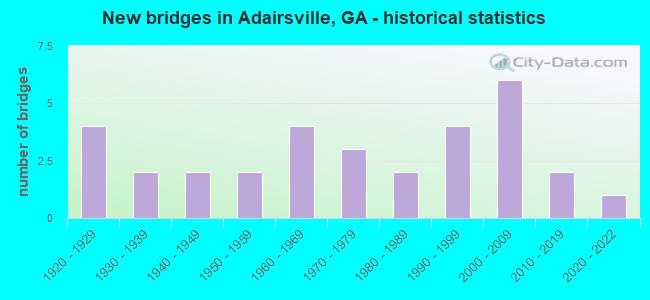
- New bridges - historical statistics
- 41920-1929
- 21930-1939
- 21940-1949
- 21950-1959
- 41960-1969
- 31970-1979
- 21980-1989
- 41990-1999
- 62000-2009
- 22010-2019
- 12020-2022

- Reconstructed bridges - Historical Statistics
- 31940-1949
- 01950-1959
- 01960-1969
- 01970-1979
- 31980-1989


- Bridge Condition - Deck
- 5.6%Very good
- 50.0%Good
- 33.3%Satisfactory
- 11.1%Fair

- Bridge Condition - Superstructure
- 27.8%Very good
- 38.9%Good
- 22.2%Satisfactory
- 11.1%Fair

- Bridge Condition - Substructure
- 5.6%Very good
- 61.1%Good
- 27.8%Satisfactory
- 5.6%Poor

- Bridge Condition - Channel
- 53.8%Very good
- 23.1%Good
- 19.2%Satisfactory
- 3.8%Fair

- Bridge Condition - Culverts
- 64.3%Good
- 28.6%Satisfactory
- 7.1%Poor
Find on map >> Show street view
Structure Number: 15005, Location: 1 MI SW OF BAXLEY (Lat: 31.756597, Lng: -82.379569), Route carried "on" structure: County highway 71, Year Built: 1963, Status: Posted for load, Structure Length: 2.74m (8.99ft), Average Daily Traffic: 1,400 (year 2011), Truck Traffic: 1%, Average Future Daily Traffic: 2,100 (year 2031), Design Load: H 15, Features Intersected: SWEETWATER CREEK, Facility Carried by Structure: COUNTY FARM ROAD
Minimum Vertical Clearance: 30+ m (98+ ft), Kilometerpoint: 0.000, Lanes on structure: 2, Base Highway Network: Yes, Owner: County Highway Agency, Approaching Roadway Width: 6.4m (21.0ft), Material/Design: Concrete, Design/Construction: Tee Beam, Number Of Spans In Main Unit: 3, Length of Maximum Span: 9.1m (29.9ft), Curb or Sidewalk Widths: Left: 0.6m (2.0ft), Right: 0.6m (2.0ft), Curb-To-Curb Width: 7.3m (24.0ft), Out-to-Out Width: 9.3m (30.5ft)
Condition: Deck: Satisfactory, Superstructure: Good, Substructure: Good, Channel: Good, Operating Rating: 30.8 metric tons, Method Used To Determine Operating Rating: Load Factor (LF), Inventory Rating: 18.1 metric tons, Method Used To Determine Inventory Rating: Load Factor (LF), Structural Evaluation: Somewhat better than minimum adequacy, Deck Geometry: Meets minimum limits, Waterway Adequacy: Better than present minimum criteria, Approach Roadway Alignment: Equal to present desirable criteria, Bridge Posting: Required (Relationship of Operating Rating to Maximum Legal Load: 10.0 - 19.9% below), Length Of Structure Improvement: 9.17m (30.09ft), Designated Inspection Frequency: Every 24 months, Inspection Date: January 2021, Bridge Improvement Cost: $352,000, Roadway Improvement Cost: $35,000, Total Project Cost: $527,000, Deck Structure Type: Concrete Cast-file-Place
Find on map >> Show street view
Structure Number: 15002, Location: 3.1 MI N OF CASSVILLE (Lat: 34.291428, Lng: -84.874778), Route carried "on" structure: US 41, Year Built: 1936, Year Reconstructed: 1949, Status: Open, Structure Length: 0.88m (2.89ft), Average Daily Traffic: 6,860 (year 2011), Truck Traffic: 1%, Average Future Daily Traffic: 10,290 (year 2031), Design Load: H 15, Features Intersected: CLEAR CREEK
Minimum Vertical Clearance: 30+ m (98+ ft), Kilometerpoint: 32.187, Lanes on structure: 2, Base Highway Network: Yes, Owner: State Highway Agency, Approaching Roadway Width: 12.2m (40.0ft), Material/Design: Concrete, Design/Construction: Culvert, Number Of Spans In Main Unit: 3, Length of Maximum Span: 2.7m (8.9ft)
Condition: Channel: Very good, Culverts: Good, Structural Evaluation: Better than present minimum criteria, Waterway Adequacy: Superior to present desirable criteria, Approach Roadway Alignment: Equal to present desirable criteria, Designated Inspection Frequency: Every 24 months, Inspection Date: August 2020, Bridge Improvement Cost: $113,000, Roadway Improvement Cost: $11,000, Total Project Cost: $170,000
Find on map >> Show street view
Structure Number: 150022, Location: 1 MI S OF ADAIRSVILLE (Lat: 34.358839, Lng: -84.923358), Route carried "on" structure: US 41, Year Built: 1949, Status: Open, Structure Length: 0.98m (3.22ft), Average Daily Traffic: 9,950 (year 2011), Truck Traffic: 5%, Average Future Daily Traffic: 14,925 (year 2031), Design Load: H 15, Features Intersected: OOTHKALOOGA CREEK TRIB.
Minimum Vertical Clearance: 30+ m (98+ ft), Kilometerpoint: 41.843, Lanes on structure: 2, Base Highway Network: Yes, Owner: State Highway Agency, Approaching Roadway Width: 8.5m (27.9ft), Material/Design: Concrete, Design/Construction: Culvert, Number Of Spans In Main Unit: 3, Length of Maximum Span: 3.0m (9.8ft)
Condition: Channel: Good, Culverts: Satisfactory, Operating Rating: 73.4 metric tons, Method Used To Determine Operating Rating: Load Factor (LF), Inventory Rating: 43.5 metric tons, Method Used To Determine Inventory Rating: Load Factor (LF), Structural Evaluation: Equal to present minimum criteria, Waterway Adequacy: Superior to present desirable criteria, Approach Roadway Alignment: Equal to present desirable criteria, Designated Inspection Frequency: Every 24 months, Inspection Date: September 2020, Bridge Improvement Cost: $125,000, Roadway Improvement Cost: $13,000, Total Project Cost: $188,000
Find on map >> Show street view
Structure Number: 150023, Location: 1.2 MI N OF ADAIRSVILLE (Lat: 34.385197, Lng: -84.935019), Route carried "on" structure: US 41, Year Built: 1949, Status: Open, Structure Length: 1.01m (3.31ft), Average Daily Traffic: 8,600 (year 2011), Truck Traffic: 1%, Average Future Daily Traffic: 12,900 (year 2031), Design Load: H 15, Features Intersected: CHAMLEE CREEK
Minimum Vertical Clearance: 30+ m (98+ ft), Kilometerpoint: 45.062, Lanes on structure: 2, Base Highway Network: Yes, Owner: State Highway Agency, Approaching Roadway Width: 8.8m (28.9ft), Skew: 2 degrees, Material/Design: Concrete, Design/Construction: Culvert, Number Of Spans In Main Unit: 3, Length of Maximum Span: 3.0m (9.8ft)
Condition: Channel: Very good, Culverts: Satisfactory, Operating Rating: 46.2 metric tons, Method Used To Determine Operating Rating: Load Factor (LF), Inventory Rating: 27.2 metric tons, Method Used To Determine Inventory Rating: Load Factor (LF), Structural Evaluation: Equal to present minimum criteria, Waterway Adequacy: Superior to present desirable criteria, Approach Roadway Alignment: Equal to present desirable criteria, Designated Inspection Frequency: Every 24 months, Inspection Date: July 2020, Bridge Improvement Cost: $129,000, Roadway Improvement Cost: $13,000, Total Project Cost: $193,000
Find on map >> Show street view
Structure Number: 15005, Location: IN EAST ADAIRSVILLE (Lat: 34.377189, Lng: -84.911119), Route carried "on" structure: State highway 140, Year Built: 1965, Year Reconstructed: 1991, Status: Open, Structure Length: 8.60m (28.22ft), Average Daily Traffic: 4,350 (year 2011), Truck Traffic: 1%, Average Future Daily Traffic: 6,525 (year 2031), Design Load: HS 20+Mod, Features Intersected: I-75
Minimum Vertical Clearance: 30+ m (98+ ft), Kilometerpoint: 9.656, Lanes on structure: 5, Lanes under structure: 6, Base Highway Network: Yes, Owner: State Highway Agency, Approaching Roadway Width: 23.2m (76.1ft), Skew: 2 degrees, Material/Design: Steel, Design/Construction: Stringer/Multi-beam, Number Of Spans In Main Unit: 4, Length of Maximum Span: 23.2m (76.1ft), Curb-To-Curb Width: 25.0m (82.0ft), Out-to-Out Width: 26.0m (85.3ft)
Condition: Deck: Good, Superstructure: Good, Substructure: Good, Operating Rating: 49.8 metric tons, Method Used To Determine Operating Rating: Load Factor (LF), Inventory Rating: 29.9 metric tons, Method Used To Determine Inventory Rating: Load Factor (LF), Structural Evaluation: Better than present minimum criteria, Deck Geometry: Superior to present desirable criteria, Underclear: Meets minimum limits, Approach Roadway Alignment: Equal to present desirable criteria, Designated Inspection Frequency: Every 24 months, Inspection Date: July 2020, Bridge Improvement Cost: $2,003,000, Roadway Improvement Cost: $200,000, Total Project Cost: $3,005,000, Deck Structure Type: Concrete Cast-file-Place, Wearing Surface/Protective System: Wearing Surface: Epoxy Overlay
Find on map >> Show street view
Structure Number: 150051, Location: 4.9 MI E OF ADAIRSVILLE (Lat: 34.387289, Lng: -84.854989), Route carried "on" structure: State highway 140, Year Built: 1973, Year Reconstructed: 1992, Status: Open, Structure Length: 1.01m (3.31ft), Average Daily Traffic: 4,350 (year 2011), Truck Traffic: 1%, Average Future Daily Traffic: 6,525 (year 2031), Design Load: HS 20+Mod, Features Intersected: DRY CREEK
Minimum Vertical Clearance: 30+ m (98+ ft), Kilometerpoint: 14.484, Lanes on structure: 2, Base Highway Network: Yes, Owner: State Highway Agency, Approaching Roadway Width: 8.5m (27.9ft), Skew: 1 degrees, Material/Design: Concrete, Design/Construction: Culvert, Number Of Spans In Main Unit: 3, Length of Maximum Span: 3.4m (11.2ft)
Condition: Channel: Satisfactory, Culverts: Good, Inventory Rating: 95.2 metric tons, Method Used To Determine Inventory Rating: Load Factor (LF), Structural Evaluation: Better than present minimum criteria, Waterway Adequacy: Superior to present desirable criteria, Approach Roadway Alignment: Equal to present desirable criteria, Designated Inspection Frequency: Every 24 months, Inspection Date: September 2020, Bridge Improvement Cost: $129,000, Roadway Improvement Cost: $13,000, Total Project Cost: $193,000
Find on map >> Show street view
Structure Number: 150056, Location: 4.7 MI SE OF ADAIRSVILLE (Lat: 34.335108, Lng: -84.864358), Route carried "on" structure: County highway 144, Year Built: 1970, Status: Open, Structure Length: 8.32m (27.30ft), Average Daily Traffic: 600 (year 2011), Truck Traffic: 1%, Average Future Daily Traffic: 900 (year 2031), Design Load: HS 15, Features Intersected: I-75, Facility Carried by Structure: PLEASANT VALLEY RD
Minimum Vertical Clearance: 30+ m (98+ ft), Kilometerpoint: 0.000, Lanes on structure: 2, Lanes under structure: 6, Base Highway Network: Yes, Owner: State Highway Agency, Approaching Roadway Width: 6.1m (20.0ft), Material/Design: Steel continuous, Design/Construction: Stringer/Multi-beam, Number Of Spans In Main Unit: 4, Length of Maximum Span: 26.8m (87.9ft), Curb or Sidewalk Widths: Left: 0.3m (1.0ft), Right: 0.3m (1.0ft), Curb-To-Curb Width: 8.1m (26.6ft), Out-to-Out Width: 9.4m (30.8ft)
Condition: Deck: Satisfactory, Superstructure: Good, Substructure: Good, Operating Rating: 24.4 metric tons, Method Used To Determine Operating Rating: Load Factor (LF), Inventory Rating: 14.5 metric tons, Method Used To Determine Inventory Rating: Load Factor (LF), Structural Evaluation: Meets minimum limits, Deck Geometry: Somewhat better than minimum adequacy, Underclear: Better than present minimum criteria, Approach Roadway Alignment: Equal to present desirable criteria, Designated Inspection Frequency: Every 24 months, Inspection Date: August 2020, Bridge Improvement Cost: $1,067,000, Roadway Improvement Cost: $107,000, Total Project Cost: $1,600,000, Deck Structure Type: Concrete Cast-file-Place
Find on map >> Show street view
Structure Number: 150104, Location: 2.7 MI E OF ADAIRSVILLE (Lat: 34.358239, Lng: -84.890308), Route carried "on" structure: Interstate 75, Year Built: 1970, Year Reconstructed: 1987, Status: Open, Structure Length: 6.00m (19.69ft), Average Daily Traffic: 58,100 (year 2011), Truck Traffic: 1%, Average Future Daily Traffic: 87,150 (year 2031), Design Load: HS 20+Mod, Features Intersected: CR 452 ADAIRSVL-PLEASANT
Minimum Vertical Clearance: 30+ m (98+ ft), Kilometerpoint: 489.241, Lanes on structure: 3, Lanes under structure: 2, Base Highway Network: Yes, Owner: State Highway Agency, Approaching Roadway Width: 17.1m (56.1ft), Skew: 12 degrees, Material/Design: Steel continuous, Design/Construction: Stringer/Multi-beam, Number Of Spans In Main Unit: 3, Length of Maximum Span: 20.7m (67.9ft), Curb-To-Curb Width: 17.7m (58.1ft), Out-to-Out Width: 18.5m (60.7ft)
Condition: Deck: Good, Superstructure: Good, Substructure: Good, Operating Rating: 34.4 metric tons, Method Used To Determine Operating Rating: Load Factor (LF), Inventory Rating: 20.8 metric tons, Method Used To Determine Inventory Rating: Load Factor (LF), Structural Evaluation: Somewhat better than minimum adequacy, Deck Geometry: Better than present minimum criteria, Underclear: Superior to present desirable criteria, Approach Roadway Alignment: Equal to present desirable criteria, Designated Inspection Frequency: Every 24 months, Inspection Date: October 2020, Bridge Improvement Cost: $980,000, Roadway Improvement Cost: $98,000, Total Project Cost: $1,469,000, Deck Structure Type: Concrete Cast-file-Place, Wearing Surface/Protective System: Wearing Surface: Epoxy Overlay
Find on map >> Show street view
Structure Number: 150113, Location: IN WEST ADAIRSVILLE (Lat: 34.367589, Lng: -84.942739), Route carried "on" structure: County highway 829, Year Built: 1959, Status: Posted for load, Structure Length: 3.90m (12.80ft), Average Daily Traffic: 2,130 (year 2011), Truck Traffic: 1%, Average Future Daily Traffic: 3,195 (year 2031), Design Load: H 15, Features Intersected: OOTHKALOOGA CREEK, Facility Carried by Structure: HALL STATION ROAD
Minimum Vertical Clearance: 30+ m (98+ ft), Kilometerpoint: 16.093, Lanes on structure: 2, Base Highway Network: Yes, Owner: County Highway Agency, Approaching Roadway Width: 6.7m (22.0ft), Skew: 3 degrees, Material/Design: Concrete, Design/Construction: Tee Beam, Number Of Spans In Main Unit: 4, Length of Maximum Span: 9.8m (32.2ft), Curb or Sidewalk Widths: Left: 0.7m (2.3ft), Right: 0.7m (2.3ft), Curb-To-Curb Width: 8.0m (26.2ft), Out-to-Out Width: 9.6m (31.5ft)
Condition: Deck: Satisfactory, Superstructure: Good, Substructure: Good, Channel: Good, Operating Rating: 27.2 metric tons, Method Used To Determine Operating Rating: Load Factor (LF), Inventory Rating: 16.3 metric tons, Method Used To Determine Inventory Rating: Load Factor (LF), Structural Evaluation: Meets minimum limits, Deck Geometry: High priority of corrective action, Waterway Adequacy: Equal to present desirable criteria, Approach Roadway Alignment: Equal to present desirable criteria, Bridge Posting: Required (Relationship of Operating Rating to Maximum Legal Load: 10.0 - 19.9% below), Designated Inspection Frequency: Every 24 months, Inspection Date: July 2020, Bridge Improvement Cost: $500,000, Roadway Improvement Cost: $50,000, Total Project Cost: $750,000, Deck Structure Type: Concrete Cast-file-Place
Find on map >> Show street view
Structure Number: 155024, Location: 2.6 MI SE OF ADAIRSVILLE (Lat: 34.323950, Lng: -84.924258), Route carried "on" structure: County highway 126, Year Built: 1928, Year Reconstructed: 1940, Status: Open, Structure Length: 1.25m (4.10ft), Average Daily Traffic: 600 (year 2011), Truck Traffic: 1%, Average Future Daily Traffic: 900 (year 2031), Features Intersected: OOTHKALOOGA CREEK TRIB, Facility Carried by Structure: WHITE ROAD
Minimum Vertical Clearance: 30+ m (98+ ft), Kilometerpoint: 8.047, Lanes on structure: 2, Base Highway Network: Yes, Owner: County Highway Agency, Approaching Roadway Width: 5.8m (19.0ft), Skew: 1 degrees, Material/Design: Steel continuous, Design/Construction: Stringer/Multi-beam, Number Of Spans In Main Unit: 2, Length of Maximum Span: 6.4m (21.0ft), Curb-To-Curb Width: 6.1m (20.0ft), Out-to-Out Width: 6.3m (20.7ft)
Condition: Deck: Satisfactory, Superstructure: Satisfactory, Substructure: Satisfactory, Channel: Satisfactory, Operating Rating: 41.7 metric tons, Method Used To Determine Operating Rating: Load Factor (LF), Inventory Rating: 25.4 metric tons, Method Used To Determine Inventory Rating: Load Factor (LF), Structural Evaluation: Equal to present minimum criteria, Deck Geometry: High priority of corrective action, Waterway Adequacy: Better than present minimum criteria, Approach Roadway Alignment: Equal to present minimum criteria, Length Of Structure Improvement: 41.48m (136.09ft), Designated Inspection Frequency: Every 24 months, Inspection Date: August 2020, Bridge Improvement Cost: $160,000, Roadway Improvement Cost: $16,000, Total Project Cost: $240,000, Deck Structure Type: Concrete Cast-file-Place, Wearing Surface/Protective System: Wearing Surface: Bituminous
Find on map >> Show street view
Structure Number: 155025, Location: 4.4 MI E OF ADAIRSVILLE (Lat: 34.361647, Lng: -84.863189), Route carried "on" structure: County highway 145, Year Built: 1928, Year Reconstructed: 1945, Status: Open, Structure Length: 0.76m (2.49ft), Average Daily Traffic: 230 (year 2011), Truck Traffic: 1%, Average Future Daily Traffic: 345 (year 2031), Features Intersected: DRY CREEK, Facility Carried by Structure: MOSTELLERS MILL RD
Minimum Vertical Clearance: 30+ m (98+ ft), Kilometerpoint: 3.219, Lanes on structure: 2, Base Highway Network: Yes, Owner: County Highway Agency, Approaching Roadway Width: 5.8m (19.0ft), Skew: 5 degrees, Material/Design: Steel, Design/Construction: Stringer/Multi-beam, Number Of Spans In Main Unit: 1, Length of Maximum Span: 7.6m (24.9ft), Curb-To-Curb Width: 6.1m (20.0ft), Out-to-Out Width: 6.1m (20.0ft)
Condition: Deck: Good, Superstructure: Satisfactory, Substructure: Satisfactory, Channel: Very good, Operating Rating: 40.8 metric tons, Method Used To Determine Operating Rating: Load Factor (LF), Inventory Rating: 25.4 metric tons, Method Used To Determine Inventory Rating: Load Factor (LF), Structural Evaluation: Equal to present minimum criteria, Deck Geometry: Meets minimum limits, Waterway Adequacy: Equal to present desirable criteria, Approach Roadway Alignment: Equal to present minimum criteria, Designated Inspection Frequency: Every 24 months, Inspection Date: September 2020, Bridge Improvement Cost: $98,000, Roadway Improvement Cost: $10,000, Total Project Cost: $147,000, Deck Structure Type: Concrete Cast-file-Place, Wearing Surface/Protective System: Wearing Surface: Bituminous
Find on map >> Show street view
Structure Number: 155055, Location: 1.8 MI N OF ADAIRSVILLE (Lat: 34.395578, Lng: -84.934628), Route carried "on" structure: County highway 315, Year Built: 1929, Status: Posted for load, Structure Length: 0.79m (2.59ft), Average Daily Traffic: 600 (year 2011), Truck Traffic: 1%, Average Future Daily Traffic: 900 (year 2031), Design Load: H 15, Features Intersected: OOTHKALOOGA CREEK TRIB, Facility Carried by Structure: OLD DIXIE HIGHWAY
Minimum Vertical Clearance: 30+ m (98+ ft), Kilometerpoint: 0.000, Lanes on structure: 2, Base Highway Network: Yes, Owner: County Highway Agency, Approaching Roadway Width: 5.5m (18.0ft), Material/Design: Concrete, Design/Construction: Tee Beam, Number Of Spans In Main Unit: 1, Length of Maximum Span: 7.9m (25.9ft), Curb or Sidewalk Widths: Left: 0.2m (0.7ft), Right: 0.2m (0.7ft), Curb-To-Curb Width: 5.5m (18.0ft), Out-to-Out Width: 6.4m (21.0ft)
Condition: Deck: Satisfactory, Superstructure: Satisfactory, Substructure: Satisfactory, Channel: Very good, Operating Rating: 39.0 metric tons, Method Used To Determine Operating Rating: Load Factor (LF), Inventory Rating: 23.5 metric tons, Method Used To Determine Inventory Rating: Load Factor (LF), Structural Evaluation: Equal to present minimum criteria, Deck Geometry: High priority of replacement, Waterway Adequacy: Superior to present desirable criteria, Approach Roadway Alignment: Equal to present minimum criteria, Length Of Structure Improvement: 41.03m (134.61ft), Designated Inspection Frequency: Every 24 months, Inspection Date: July 2020, Bridge Improvement Cost: $102,000, Roadway Improvement Cost: $10,000, Total Project Cost: $152,000, Deck Structure Type: Concrete Cast-file-Place, Wearing Surface/Protective System: Wearing Surface: Bituminous
Find on map >> Show street view
Structure Number: 155056, Location: 1.2 MI N OF ADAIRSVILLE (Lat: 34.385158, Lng: -84.935247), Route carried "on" structure: County highway 315, Year Built: 1929, Status: Open, Structure Length: 1.83m (6.00ft), Average Daily Traffic: 600 (year 2011), Truck Traffic: 1%, Average Future Daily Traffic: 900 (year 2031), Design Load: H 15, Features Intersected: CHAMLEE CREEK, Facility Carried by Structure: OLD DIXIE HIGHWAY
Minimum Vertical Clearance: 30+ m (98+ ft), Kilometerpoint: 1.609, Lanes on structure: 2, Base Highway Network: Yes, Owner: County Highway Agency, Approaching Roadway Width: 5.8m (19.0ft), Material/Design: Concrete, Design/Construction: Tee Beam, Number Of Spans In Main Unit: 3, Length of Maximum Span: 6.1m (20.0ft), Curb or Sidewalk Widths: Left: 0.2m (0.7ft), Right: 0.2m (0.7ft), Curb-To-Curb Width: 5.5m (18.0ft), Out-to-Out Width: 6.4m (21.0ft)
Condition: Deck: Fair, Superstructure: Fair, Substructure: Poor, Channel: Satisfactory, Operating Rating: 31.7 metric tons, Method Used To Determine Operating Rating: Allowable Stress (AS), Inventory Rating: 19.9 metric tons, Method Used To Determine Inventory Rating: Allowable Stress (AS), Structural Evaluation: Meets minimum limits, Deck Geometry: High priority of replacement, Waterway Adequacy: Superior to present desirable criteria, Approach Roadway Alignment: Equal to present minimum criteria, Length Of Structure Improvement: 42.06m (137.99ft), Designated Inspection Frequency: Every 24 months, Inspection Date: July 2020, Bridge Improvement Cost: $234,000, Roadway Improvement Cost: $23,000, Total Project Cost: $352,000, Deck Structure Type: Concrete Cast-file-Place, Wearing Surface/Protective System: Wearing Surface: Bituminous
Find on map >> Show street view
Structure Number: 155057, Location: 1.2 MI N OF ADAIRSVILLE (Lat: 34.384408, Lng: -84.943619), Route carried "on" structure: County highway 316, Year Built: 1989, Status: Open, Structure Length: 4.57m (14.99ft), Average Daily Traffic: 760 (year 2011), Truck Traffic: 1%, Average Future Daily Traffic: 1,140 (year 2031), Design Load: HS 20+Mod, Features Intersected: OOTHKALOOGA CREEK, Facility Carried by Structure: WOODY ROAD
Minimum Vertical Clearance: 30+ m (98+ ft), Kilometerpoint: 1.609, Lanes on structure: 2, Base Highway Network: Yes, Owner: County Highway Agency, Approaching Roadway Width: 6.4m (21.0ft), Material/Design: Prestressed concrete, Design/Construction: Stringer/Multi-beam, Number Of Spans In Main Unit: 2, Length of Maximum Span: 22.9m (75.1ft), Curb-To-Curb Width: 8.5m (27.9ft), Out-to-Out Width: 9.5m (31.2ft)
Condition: Deck: Good, Superstructure: Very good, Substructure: Good, Channel: Satisfactory, Operating Rating: 60.7 metric tons, Method Used To Determine Operating Rating: Load Factor (LF), Inventory Rating: 27.2 metric tons, Method Used To Determine Inventory Rating: Load Factor (LF), Structural Evaluation: Equal to present minimum criteria, Deck Geometry: Somewhat better than minimum adequacy, Waterway Adequacy: Equal to present desirable criteria, Approach Roadway Alignment: Equal to present desirable criteria, Designated Inspection Frequency: Every 24 months, Inspection Date: September 2020, Bridge Improvement Cost: $586,000, Roadway Improvement Cost: $59,000, Total Project Cost: $879,000, Deck Structure Type: Concrete Cast-file-Place
Find on map >> Show street view
Structure Number: 155065, Location: 0.5 MI W OF ADAIRSVILLE (Lat: 34.370697, Lng: -84.944558), Route carried "on" structure: County highway 410, Year Built: 1991, Status: Open, Structure Length: 6.10m (20.01ft), Average Daily Traffic: 600 (year 2011), Truck Traffic: 1%, Average Future Daily Traffic: 900 (year 2031), Design Load: HS 20+Mod, Features Intersected: OOTHKALOOGA CREEK, Facility Carried by Structure: TWIN BRIDGES ROAD
Minimum Vertical Clearance: 30+ m (98+ ft), Kilometerpoint: 3.219, Lanes on structure: 2, Base Highway Network: Yes, Owner: County Highway Agency, Approaching Roadway Width: 6.1m (20.0ft), Skew: 1 degrees, Material/Design: Prestressed concrete, Design/Construction: Stringer/Multi-beam, Number Of Spans In Main Unit: 5, Length of Maximum Span: 12.2m (40.0ft), Curb-To-Curb Width: 9.1m (29.9ft), Out-to-Out Width: 10.1m (33.1ft)
Condition: Deck: Very good, Superstructure: Very good, Substructure: Very good, Channel: Very good, Operating Rating: 64.4 metric tons, Method Used To Determine Operating Rating: Load Factor (LF), Inventory Rating: 37.1 metric tons, Method Used To Determine Inventory Rating: Load Factor (LF), Structural Evaluation: Equal to present desirable criteria, Deck Geometry: Equal to present minimum criteria, Waterway Adequacy: Equal to present desirable criteria, Approach Roadway Alignment: Equal to present desirable criteria, Designated Inspection Frequency: Every 24 months, Inspection Date: July 2020, Bridge Improvement Cost: $781,000, Roadway Improvement Cost: $78,000, Total Project Cost: $1,172,000, Deck Structure Type: Concrete Cast-file-Place
Find on map >> Show street view
Structure Number: 155094, Location: 1 MI S OF ADAIRSVILLE (Lat: 34.358269, Lng: -84.934758), Route carried "on" structure: County highway 114, Year Built: 1995, Status: Open, Structure Length: 1.58m (5.18ft), Average Daily Traffic: 660 (year 2011), Truck Traffic: 1%, Average Future Daily Traffic: 990 (year 2031), Design Load: HS 20+Mod, Features Intersected: OOTHKALOOGA CREEK TRIB, Facility Carried by Structure: RAILROAD STREET
Minimum Vertical Clearance: 30+ m (98+ ft), Kilometerpoint: 0.000, Lanes on structure: 2, Base Highway Network: Yes, Owner: County Highway Agency, Approaching Roadway Width: 7.3m (24.0ft), Skew: 1 degrees, Material/Design: Concrete, Design/Construction: Culvert, Number Of Spans In Main Unit: 5, Length of Maximum Span: 3.0m (9.8ft)
Condition: Channel: Very good, Culverts: Good, Operating Rating: 55.3 metric tons, Method Used To Determine Operating Rating: Field evaluation and documented engineering judgment, Inventory Rating: 32.6 metric tons, Method Used To Determine Inventory Rating: Field evaluation and documented engineering judgment, Structural Evaluation: Better than present minimum criteria, Waterway Adequacy: Equal to present desirable criteria, Approach Roadway Alignment: Equal to present desirable criteria, Designated Inspection Frequency: Every 24 months, Inspection Date: September 2020, Bridge Improvement Cost: $203,000, Roadway Improvement Cost: $20,000, Total Project Cost: $305,000
Find on map >> Show street view
Structure Number: 155098, Location: 1.9 MI W OF ADAIRSVILLE (Lat: 34.371358, Lng: -84.967478), Route carried "on" structure: County highway 410, Year Built: 1998, Status: Open, Structure Length: 1.01m (3.31ft), Average Daily Traffic: 370 (year 2011), Truck Traffic: 1%, Average Future Daily Traffic: 555 (year 2031), Design Load: H 15, Features Intersected: SWAMP CREEK TRIB, Facility Carried by Structure: TWIN BRIDGE ROAD
Minimum Vertical Clearance: 30+ m (98+ ft), Kilometerpoint: 0.000, Lanes on structure: 2, Base Highway Network: Yes, Owner: County Highway Agency, Approaching Roadway Width: 5.2m (17.1ft), Skew: 4 degrees, Material/Design: Steel, Design/Construction: Culvert, Number Of Spans In Main Unit: 3, Length of Maximum Span: 3.0m (9.8ft)
Condition: Channel: Good, Culverts: Poor, Operating Rating: 41.7 metric tons, Method Used To Determine Operating Rating: Field evaluation and documented engineering judgment, Inventory Rating: 24.4 metric tons, Method Used To Determine Inventory Rating: Field evaluation and documented engineering judgment, Structural Evaluation: Meets minimum limits, Waterway Adequacy: Equal to present desirable criteria, Approach Roadway Alignment: Equal to present minimum criteria, Designated Inspection Frequency: Every 24 months, Inspection Date: July 2020, Bridge Improvement Cost: $129,000, Roadway Improvement Cost: $13,000, Total Project Cost: $193,000
Find on map >> Show street view
Structure Number: 155102, Location: 0.5 MI SW OF ADAIRSVILLE (Lat: 34.359219, Lng: -84.922550), Route carried "on" structure: County highway 1204, Year Built: 1939, Status: Posted for load, Structure Length: 1.98m (6.50ft), Average Daily Traffic: 40 (year 2011), Truck Traffic: 1%, Average Future Daily Traffic: 60 (year 2031), Features Intersected: SPRING CREEK, Facility Carried by Structure: SPRING CREEK CIIR.
Minimum Vertical Clearance: 30+ m (98+ ft), Kilometerpoint: 0.000, Lanes on structure: 2, Base Highway Network: Yes, Owner: County Highway Agency, Approaching Roadway Width: 4.0m (13.1ft), Material/Design: Steel, Design/Construction: Stringer/Multi-beam, Number Of Spans In Main Unit: 2, Length of Maximum Span: 12.2m (40.0ft), Curb-To-Curb Width: 6.1m (20.0ft), Out-to-Out Width: 6.1m (20.0ft)
Condition: Deck: Fair, Superstructure: Fair, Substructure: Satisfactory, Channel: Very good, Operating Rating: 22.6 metric tons, Method Used To Determine Operating Rating: Allowable Stress (AS), Inventory Rating: 12.7 metric tons, Method Used To Determine Inventory Rating: Allowable Stress (AS), Structural Evaluation: Meets minimum limits, Deck Geometry: Somewhat better than minimum adequacy, Waterway Adequacy: Equal to present minimum criteria, Approach Roadway Alignment: Equal to present desirable criteria, Bridge Posting: Required (Relationship of Operating Rating to Maximum Legal Load: 10.0 - 19.9% below), Designated Inspection Frequency: Every 24 months, Inspection Date: September 2020, Bridge Improvement Cost: $254,000, Roadway Improvement Cost: $25,000, Total Project Cost: $381,000, Deck Structure Type: Concrete Cast-file-Place
Find on map >> Show street view
Structure Number: 155105, Location: 5 MI. N. OF KINGSTON (Lat: 34.306269, Lng: -84.950519), Route carried "on" structure: County highway 104, Year Built: 2000, Status: Open, Structure Length: 0.79m (2.59ft), Average Daily Traffic: 600 (year 2011), Truck Traffic: 1%, Average Future Daily Traffic: 900 (year 2031), Design Load: HS 20+Mod, Features Intersected: SIPSEY CREEK, Facility Carried by Structure: HORSESHOE LOOP RD
Minimum Vertical Clearance: 30+ m (98+ ft), Kilometerpoint: 0.000, Lanes on structure: 2, Base Highway Network: Yes, Owner: County Highway Agency, Approaching Roadway Width: 4.3m (14.1ft), Skew: 3 degrees, Material/Design: Concrete, Design/Construction: Culvert, Number Of Spans In Main Unit: 2, Length of Maximum Span: 4.0m (13.1ft)
Condition: Channel: Very good, Culverts: Good, Operating Rating: 55.3 metric tons, Method Used To Determine Operating Rating: Field evaluation and documented engineering judgment, Inventory Rating: 32.6 metric tons, Method Used To Determine Inventory Rating: Field evaluation and documented engineering judgment, Structural Evaluation: Better than present minimum criteria, Waterway Adequacy: Equal to present desirable criteria, Approach Roadway Alignment: Equal to present desirable criteria, Designated Inspection Frequency: Every 24 months, Inspection Date: July 2020, Bridge Improvement Cost: $102,000, Roadway Improvement Cost: $10,000, Total Project Cost: $152,000
Find on map >> Show street view
Structure Number: 155108, Location: 4.5 MI E OF ADAIRSVILLE (Lat: 34.391219, Lng: -84.860608), Route carried "on" structure: County highway 215, Year Built: 2001, Status: Open, Structure Length: 0.98m (3.22ft), Average Daily Traffic: 820 (year 2011), Truck Traffic: 1%, Average Future Daily Traffic: 1,230 (year 2031), Design Load: HS 20+Mod, Features Intersected: BEAMAN BRANCH, Facility Carried by Structure: GREEN LOOP RD.
Minimum Vertical Clearance: 30+ m (98+ ft), Kilometerpoint: 0.000, Lanes on structure: 2, Base Highway Network: Yes, Owner: County Highway Agency, Approaching Roadway Width: 5.5m (18.0ft), Material/Design: Concrete, Design/Construction: Culvert, Number Of Spans In Main Unit: 3, Length of Maximum Span: 3.0m (9.8ft)
Condition: Channel: Good, Culverts: Good, Operating Rating: 55.3 metric tons, Method Used To Determine Operating Rating: Field evaluation and documented engineering judgment, Inventory Rating: 32.6 metric tons, Method Used To Determine Inventory Rating: Field evaluation and documented engineering judgment, Structural Evaluation: Better than present minimum criteria, Waterway Adequacy: Equal to present desirable criteria, Approach Roadway Alignment: Equal to present desirable criteria, Designated Inspection Frequency: Every 24 months, Inspection Date: September 2020, Bridge Improvement Cost: $125,000, Roadway Improvement Cost: $13,000, Total Project Cost: $188,000
Find on map >> Show street view
Structure Number: 155109, Location: 2.0 MI S E OF ADAIRSVILLE (Lat: 34.336839, Lng: -84.924728), Route carried "on" structure: County highway 126, Year Built: 2001, Status: Open, Structure Length: 0.98m (3.22ft), Average Daily Traffic: 600 (year 2011), Truck Traffic: 1%, Average Future Daily Traffic: 900 (year 2031), Design Load: HS 20+Mod, Features Intersected: MANNING CREEK, Facility Carried by Structure: WHITE ROAD
Minimum Vertical Clearance: 30+ m (98+ ft), Kilometerpoint: 9.656, Lanes on structure: 2, Base Highway Network: Yes, Owner: County Highway Agency, Approaching Roadway Width: 5.8m (19.0ft), Material/Design: Concrete, Design/Construction: Culvert, Number Of Spans In Main Unit: 3, Length of Maximum Span: 3.0m (9.8ft)
Condition: Channel: Good, Culverts: Good, Operating Rating: 55.3 metric tons, Method Used To Determine Operating Rating: Field evaluation and documented engineering judgment, Inventory Rating: 32.6 metric tons, Method Used To Determine Inventory Rating: Field evaluation and documented engineering judgment, Structural Evaluation: Better than present minimum criteria, Waterway Adequacy: Equal to present desirable criteria, Approach Roadway Alignment: Equal to present desirable criteria, Designated Inspection Frequency: Every 24 months, Inspection Date: August 2020, Bridge Improvement Cost: $125,000, Roadway Improvement Cost: $13,000, Total Project Cost: $188,000
Find on map >> Show street view
Structure Number: 155121, Location: WEST OF ADAIRSVILLE (Lat: 34.375950, Lng: -84.974008), Route carried "on" structure: County highway 1302, Year Built: 2001, Status: Open, Structure Length: 0.67m (2.20ft), Average Daily Traffic: 590 (year 2011), Truck Traffic: 1%, Average Future Daily Traffic: 885 (year 2031), Design Load: H 15, Features Intersected: OOTHKALOOGA CREEK TRIB., Facility Carried by Structure: WESLEY MILL DRIVE
Minimum Vertical Clearance: 30+ m (98+ ft), Kilometerpoint: 0.000, Lanes on structure: 2, Base Highway Network: Yes, Owner: County Highway Agency, Approaching Roadway Width: 7.0m (23.0ft), Material/Design: Steel, Design/Construction: Culvert, Number Of Spans In Main Unit: 3, Length of Maximum Span: 1.8m (5.9ft)
Condition: Channel: Very good, Culverts: Satisfactory, Operating Rating: 43.5 metric tons, Method Used To Determine Operating Rating: Field evaluation and documented engineering judgment, Inventory Rating: 24.4 metric tons, Method Used To Determine Inventory Rating: Field evaluation and documented engineering judgment, Structural Evaluation: Equal to present minimum criteria, Waterway Adequacy: Superior to present desirable criteria, Approach Roadway Alignment: Equal to present desirable criteria, Designated Inspection Frequency: Every 24 months, Inspection Date: July 2020, Bridge Improvement Cost: $86,000, Roadway Improvement Cost: $9,000, Total Project Cost: $129,000
Find on map >> Show street view
Structure Number: 155122, Location: 2.6 MI SE OF ADAIRSVILLE (Lat: 34.337697, Lng: -84.912319), Route carried "on" structure: County highway 122, Year Built: 2006, Status: Open, Structure Length: 0.98m (3.22ft), Average Daily Traffic: 1,610 (year 2011), Truck Traffic: 1%, Average Future Daily Traffic: 2,415 (year 2031), Design Load: HS 20+Mod, Features Intersected: MANNING CREEK, Facility Carried by Structure: OLD DIXIE HIGHWAY
Minimum Vertical Clearance: 30+ m (98+ ft), Kilometerpoint: 3.219, Lanes on structure: 3, Base Highway Network: Yes, Owner: County Highway Agency, Approaching Roadway Width: 9.4m (30.8ft), Material/Design: Concrete, Design/Construction: Culvert, Number Of Spans In Main Unit: 3, Length of Maximum Span: 3.0m (9.8ft)
Condition: Channel: Very good, Culverts: Good, Operating Rating: 55.3 metric tons, Method Used To Determine Operating Rating: Field evaluation and documented engineering judgment, Inventory Rating: 32.6 metric tons, Method Used To Determine Inventory Rating: Field evaluation and documented engineering judgment, Structural Evaluation: Better than present minimum criteria, Waterway Adequacy: Equal to present minimum criteria, Approach Roadway Alignment: Equal to present desirable criteria, Designated Inspection Frequency: Every 24 months, Inspection Date: September 2020, Bridge Improvement Cost: $125,000, Roadway Improvement Cost: $13,000, Total Project Cost: $188,000
Find on map >> Show street view
Structure Number: 155124, Location: JUST S OF ADAIRSVILLE (Lat: 34.358289, Lng: -84.925169), Route carried "on" structure: County highway 122, Year Built: 2007, Status: Open, Structure Length: 1.16m (3.81ft), Average Daily Traffic: 1,470 (year 2011), Truck Traffic: 1%, Average Future Daily Traffic: 2,205 (year 2031), Design Load: HS 20+Mod, Features Intersected: OOTHKALOOGA CREEK, Facility Carried by Structure: OLD DIXIE HIGHWAY
Minimum Vertical Clearance: 30+ m (98+ ft), Kilometerpoint: 1.609, Lanes on structure: 2, Base Highway Network: Yes, Owner: County Highway Agency, Approaching Roadway Width: 5.5m (18.0ft), Skew: 2 degrees, Material/Design: Concrete, Design/Construction: Culvert, Number Of Spans In Main Unit: 4, Length of Maximum Span: 2.7m (8.9ft)
Condition: Channel: Satisfactory, Culverts: Good, Operating Rating: 55.3 metric tons, Method Used To Determine Operating Rating: Field evaluation and documented engineering judgment, Inventory Rating: 32.6 metric tons, Method Used To Determine Inventory Rating: Field evaluation and documented engineering judgment, Structural Evaluation: Better than present minimum criteria, Waterway Adequacy: Superior to present desirable criteria, Approach Roadway Alignment: Equal to present desirable criteria, Designated Inspection Frequency: Every 24 months, Inspection Date: September 2020, Bridge Improvement Cost: $148,000, Roadway Improvement Cost: $15,000, Total Project Cost: $223,000
Find on map >> Show street view
Structure Number: 155147, Location: IN WEST ADAIRSVILLE (Lat: 34.376569, Lng: -84.942997), Route carried "on" structure: State highway 140, Year Built: 2017, Status: Open, Structure Length: 6.71m (22.01ft), Average Daily Traffic: 27,270 (year 2015), Truck Traffic: 9%, Average Future Daily Traffic: 33,265 (year 2035), Design Load: HS 20+Mod, Features Intersected: OOTHKALOOGA CREEK
Minimum Vertical Clearance: 30+ m (98+ ft), Kilometerpoint: 6.437, Lanes on structure: 4, Base Highway Network: Yes, Owner: State Highway Agency, Approaching Roadway Width: 7.5m (24.6ft), Skew: 20 degrees, Material/Design: Concrete, Design/Construction: Stringer/Multi-beam, Number Of Spans In Main Unit: 3, Length of Maximum Span: 24.4m (80.1ft), Curb or Sidewalk Widths: Left: 1.7m (5.6ft), Right: 1.7m (5.6ft), Curb-To-Curb Width: 24.1m (79.1ft), Out-to-Out Width: 28.2m (92.5ft)
Condition: Deck: Good, Superstructure: Very good, Substructure: Good, Channel: Very good, Operating Rating: 72.5 metric tons, Method Used To Determine Operating Rating: Load Factor (LF), Inventory Rating: 43.5 metric tons, Method Used To Determine Inventory Rating: Load Factor (LF), Structural Evaluation: Better than present minimum criteria, Deck Geometry: Superior to present desirable criteria, Waterway Adequacy: Superior to present desirable criteria, Approach Roadway Alignment: Equal to present desirable criteria, Length Of Structure Improvement: 8.05m (26.41ft), Designated Inspection Frequency: Every 24 months, Inspection Date: September 2020, Bridge Improvement Cost: $19,536,000, Roadway Improvement Cost: $1,954,000, Total Project Cost: $29,304,000 ( Estimate for 2018), Deck Structure Type: Concrete Cast-file-Place
Find on map >> Show street view
Structure Number: 155148, Location: IN WEST ADAIRSVILLE (Lat: 34.376939, Lng: -84.936389), Route carried "on" structure: State highway 140, Year Built: 2017, Status: Open, Structure Length: 5.73m (18.80ft), Average Daily Traffic: 27,270 (year 2015), Truck Traffic: 9%, Average Future Daily Traffic: 33,265 (year 2035), Design Load: HS 20+Mod, Features Intersected: CSX RAILROAD (340492V)
Minimum Vertical Clearance: 30+ m (98+ ft), Kilometerpoint: 6.437, Lanes on structure: 6, Base Highway Network: Yes, Owner: State Highway Agency, Approaching Roadway Width: 7.5m (24.6ft), Material/Design: Concrete, Design/Construction: Stringer/Multi-beam, Number Of Spans In Main Unit: 3, Length of Maximum Span: 31.1m (102.0ft), Curb or Sidewalk Widths: Left: 1.7m (5.6ft), Right: 1.7m (5.6ft), Curb-To-Curb Width: 27.9m (91.5ft), Out-to-Out Width: 31.9m (104.7ft)
Condition: Deck: Good, Superstructure: Very good, Substructure: Good, Operating Rating: 66.2 metric tons, Method Used To Determine Operating Rating: Load Factor (LF), Inventory Rating: 39.0 metric tons, Method Used To Determine Inventory Rating: Load Factor (LF), Structural Evaluation: Better than present minimum criteria, Deck Geometry: Superior to present desirable criteria, Underclear: Superior to present desirable criteria, Approach Roadway Alignment: Equal to present desirable criteria, Length Of Structure Improvement: 6.89m (22.60ft), Designated Inspection Frequency: Every 24 months, Inspection Date: September 2020, Bridge Improvement Cost: $16,724,000, Roadway Improvement Cost: $1,673,000, Total Project Cost: $25,086,000 ( Estimate for 2018), Deck Structure Type: Concrete Cast-file-Place
Find on map >> Show street view
Structure Number: 155153, Location: 4 MI S OF ADAIRSVILLE (Lat: 34.320197, Lng: -84.899050), Route carried "on" structure: US 41, Year Built: 2020, Status: Open, Structure Length: 7.35m (24.11ft), Average Daily Traffic: 8,250 (year 2017), Truck Traffic: 5%, Average Future Daily Traffic: 13,500 (year 2037), Design Load: HL 93, Features Intersected: CR 122
Minimum Vertical Clearance: 30+ m (98+ ft), Kilometerpoint: 37.015, Lanes on structure: 2, Lanes under structure: 2, Base Highway Network: Yes, Owner: State Highway Agency, Approaching Roadway Width: 10.1m (33.1ft), Skew: 4 degrees, Material/Design: Prestressed concrete, Design/Construction: Stringer/Multi-beam, Number Of Spans In Main Unit: 3, Length of Maximum Span: 44.2m (145.0ft), Curb-To-Curb Width: 12.2m (40.0ft), Out-to-Out Width: 13.1m (43.0ft)
Condition: Deck: Good, Superstructure: Very good, Substructure: Good, Operating Rating: 76.2 metric tons, Method Used To Determine Operating Rating: Load Factor (LF), Inventory Rating: 45.3 metric tons, Method Used To Determine Inventory Rating: Load Factor (LF), Structural Evaluation: Better than present minimum criteria, Deck Geometry: Somewhat better than minimum adequacy, Underclear: Meets minimum limits, Approach Roadway Alignment: Equal to present desirable criteria, Length Of Structure Improvement: 8.81m (28.90ft), Designated Inspection Frequency: Every 24 months, Inspection Date: September 2020, Bridge Improvement Cost: $21,386,000, Roadway Improvement Cost: $2,139,000, Total Project Cost: $32,079,000 ( Estimate for 2020), Deck Structure Type: Concrete Cast-file-Place, Wearing Surface/Protective System: Deck Protection: Epoxy Coated Reinforcing
Find on map >> Show street view
Structure Number: 1155017, Location: 11.9 MI NE OF ROME (Lat: 34.355408, Lng: -85.009050), Route carried "on" structure: County highway 151, Year Built: 1950, Status: Posted for load, Structure Length: 0.88m (2.89ft), Average Daily Traffic: 490 (year 2012), Truck Traffic: 1%, Average Future Daily Traffic: 735 (year 2032), Features Intersected: WOODWARD CREEK TRIB, Facility Carried by Structure: BUTTRAM ROAD
Minimum Vertical Clearance: 30+ m (98+ ft), Kilometerpoint: 0.000, Lanes on structure: 2, Base Highway Network: Yes, Owner: County Highway Agency, Approaching Roadway Width: 4.0m (13.1ft), Skew: 3 degrees, Material/Design: Steel, Design/Construction: Stringer/Multi-beam, Number Of Spans In Main Unit: 1, Length of Maximum Span: 8.8m (28.9ft), Curb or Sidewalk Widths: Left: 0.2m (0.7ft), Right: 0.2m (0.7ft), Curb-To-Curb Width: 5.0m (16.4ft), Out-to-Out Width: 5.4m (17.7ft)
Condition: Deck: Good, Superstructure: Satisfactory, Substructure: Satisfactory, Channel: Fair, Operating Rating: 18.1 metric tons, Method Used To Determine Operating Rating: Load Factor (LF), Inventory Rating: 10.8 metric tons, Method Used To Determine Inventory Rating: Load Factor (LF), Structural Evaluation: Meets minimum limits, Deck Geometry: High priority of replacement, Waterway Adequacy: Superior to present desirable criteria, Approach Roadway Alignment: Better than present minimum criteria, Bridge Posting: Required (Relationship of Operating Rating to Maximum Legal Load: > 39.9% below), Length Of Structure Improvement: 7.32m (24.02ft), Designated Inspection Frequency: Every 24 months, Inspection Date: October 2021, Bridge Improvement Cost: $113,000, Roadway Improvement Cost: $11,000, Total Project Cost: $170,000, Deck Structure Type: Concrete Cast-file-Place, Wearing Surface/Protective System: Wearing Surface: Bituminous
Find on map >> Show street view
Structure Number: 129003, Location: 6 MI S OF CALHOUN (Lat: 34.402172, Lng: -84.919178), Route carried "on" structure: County highway 71, Year Built: 1965, Status: Open, Structure Length: 8.41m (27.59ft), Average Daily Traffic: 490 (year 2012), Truck Traffic: 1%, Average Future Daily Traffic: 735 (year 2032), Design Load: H 15, Features Intersected: I-75, Facility Carried by Structure: TRIMBLE HOLLOW RD
Minimum Vertical Clearance: 30+ m (98+ ft), Kilometerpoint: 4.828, Lanes on structure: 2, Lanes under structure: 6, Base Highway Network: Yes, Owner: State Highway Agency, Approaching Roadway Width: 6.1m (20.0ft), Skew: 1 degrees, Material/Design: Steel continuous, Design/Construction: Stringer/Multi-beam, Number Of Spans In Main Unit: 4, Length of Maximum Span: 23.2m (76.1ft), Curb or Sidewalk Widths: Left: 0.7m (2.3ft), Right: 0.7m (2.3ft), Curb-To-Curb Width: 7.9m (25.9ft), Out-to-Out Width: 9.7m (31.8ft)
Condition: Deck: Satisfactory, Superstructure: Good, Substructure: Good, Operating Rating: 36.2 metric tons, Method Used To Determine Operating Rating: Load Factor (LF), Inventory Rating: 21.7 metric tons, Method Used To Determine Inventory Rating: Load Factor (LF), Structural Evaluation: Equal to present minimum criteria, Deck Geometry: Somewhat better than minimum adequacy, Underclear: Equal to present minimum criteria, Approach Roadway Alignment: Equal to present desirable criteria, Designated Inspection Frequency: Every 24 months, Inspection Date: May 2021, Bridge Improvement Cost: $1,078,000, Roadway Improvement Cost: $108,000, Total Project Cost: $1,618,000, Deck Structure Type: Concrete Cast-file-Place
Find on map >> Show street view
Structure Number: 1295012, Location: 6 MI S OF CALHOUN (Lat: 34.399178, Lng: -84.919839), Route carried "on" structure: ServiceCounty highway 71, Year Built: 1963, Status: Open, Structure Length: 1.10m (3.61ft), Average Daily Traffic: 490 (year 2012), Truck Traffic: 1%, Average Future Daily Traffic: 735 (year 2032), Design Load: HS 20+Mod, Features Intersected: OOTHKALOOGA CREEK TRIB, Facility Carried by Structure: TRIMBLE HOLLOW RD
Minimum Vertical Clearance: 30+ m (98+ ft), Kilometerpoint: 6.437, Lanes on structure: 2, Base Highway Network: Yes, Owner: County Highway Agency, Approaching Roadway Width: 6.1m (20.0ft), Skew: 3 degrees, Material/Design: Concrete, Design/Construction: Culvert, Number Of Spans In Main Unit: 4, Length of Maximum Span: 2.4m (7.9ft)
Condition: Channel: Very good, Culverts: Good, Operating Rating: 55.3 metric tons, Method Used To Determine Operating Rating: Field evaluation and documented engineering judgment, Inventory Rating: 32.6 metric tons, Method Used To Determine Inventory Rating: Field evaluation and documented engineering judgment, Structural Evaluation: Better than present minimum criteria, Waterway Adequacy: Superior to present desirable criteria, Approach Roadway Alignment: Equal to present desirable criteria, Designated Inspection Frequency: Every 24 months, Inspection Date: May 2021, Bridge Improvement Cost: $141,000, Roadway Improvement Cost: $14,000, Total Project Cost: $211,000
Find on map >> Show street view
Structure Number: 1295015, Location: 7 MI S OF CALHOUN (Lat: 34.401328, Lng: -84.943278), Route carried "on" structure: County highway 106, Year Built: 1982, Status: Posted for load, Structure Length: 6.10m (20.01ft), Average Daily Traffic: 490 (year 2012), Truck Traffic: 1%, Average Future Daily Traffic: 735 (year 2032), Design Load: HS 15, Features Intersected: OOTHKALOOGA CREEK, Facility Carried by Structure: MILLER FERRY ROAD
Minimum Vertical Clearance: 30+ m (98+ ft), Kilometerpoint: 0.000, Lanes on structure: 2, Base Highway Network: Yes, Owner: County Highway Agency, Approaching Roadway Width: 6.4m (21.0ft), Material/Design: Concrete, Design/Construction: Tee Beam, Number Of Spans In Main Unit: 5, Length of Maximum Span: 12.2m (40.0ft), Curb-To-Curb Width: 9.3m (30.5ft), Out-to-Out Width: 10.3m (33.8ft)
Condition: Deck: Good, Superstructure: Good, Substructure: Good, Channel: Very good, Operating Rating: 36.2 metric tons, Method Used To Determine Operating Rating: Load Factor (LF), Inventory Rating: 18.1 metric tons, Method Used To Determine Inventory Rating: Load Factor (LF), Structural Evaluation: Somewhat better than minimum adequacy, Deck Geometry: Equal to present minimum criteria, Waterway Adequacy: Superior to present desirable criteria, Approach Roadway Alignment: Equal to present desirable criteria, Designated Inspection Frequency: Every 24 months, Inspection Date: May 2021, Bridge Improvement Cost: $781,000, Roadway Improvement Cost: $78,000, Total Project Cost: $1,172,000, Deck Structure Type: Concrete Cast-file-Place
Find on map >> Show street view
Structure Number: 1295079, Location: 9 MI SE OF CALHOUN (Lat: 34.401889, Lng: -84.854019), Route carried "on" structure: County highway 75, Year Built: 1996, Status: Open, Structure Length: 0.70m (2.30ft), Average Daily Traffic: 490 (year 2012), Truck Traffic: 1%, Average Future Daily Traffic: 735 (year 2032), Design Load: H 15, Features Intersected: SCOTT BRANCH, Facility Carried by Structure: PLAINVIEW ROAD
Minimum Vertical Clearance: 30+ m (98+ ft), Kilometerpoint: 1.609, Lanes on structure: 2, Base Highway Network: Yes, Owner: County Highway Agency, Approaching Roadway Width: 5.5m (18.0ft), Material/Design: Steel, Design/Construction: Culvert, Number Of Spans In Main Unit: 3, Length of Maximum Span: 1.8m (5.9ft)
Condition: Channel: Very good, Culverts: Satisfactory, Operating Rating: 41.7 metric tons, Method Used To Determine Operating Rating: Field evaluation and documented engineering judgment, Inventory Rating: 24.4 metric tons, Method Used To Determine Inventory Rating: Field evaluation and documented engineering judgment, Structural Evaluation: Equal to present minimum criteria, Waterway Adequacy: Better than present minimum criteria, Approach Roadway Alignment: Equal to present desirable criteria, Designated Inspection Frequency: Every 24 months, Inspection Date: June 2021, Bridge Improvement Cost: $90,000, Roadway Improvement Cost: $9,000, Total Project Cost: $135,000
Find on map >> Show street view
Structure Number: 15005, Location: IN EAST ADAIRSVILLE (Lat: 34.377189, Lng: -84.911119), Route carried "under" structure: Interstate 75, Structure Length: 0. m, Average Daily Traffic: 54,950 (year 1999), Truck Traffic: 12%, Features Intersected: SR 140, Facility Carried by Structure: SR 140
Minimum Vertical Clearance: 5.28m (17.32ft), Kilometerpoint: 492.459, Lanes on structure: 5, Length of Maximum Span: 0.0m
Find on map >> Show street view
Structure Number: 150056, Location: 4.7 MI SE OF ADAIRSVILLE (Lat: 34.335108, Lng: -84.864358), Route carried "under" structure: Interstate 75, Structure Length: 0. m, Average Daily Traffic: 54,370 (year 1999), Truck Traffic: 12%, Features Intersected: CR144 PLEASANT VALLEY RD, Facility Carried by Structure: PLEASANT VALLEY RD
Minimum Vertical Clearance: 5.18m (16.99ft), Kilometerpoint: 486.022, Lanes on structure: 2, Length of Maximum Span: 0.0m
Find on map >> Show street view
Structure Number: 150101, Location: 5.2 MI NW OF WHITE (Lat: 34.308950, Lng: -84.836406), Route carried "under" structure: County highway 179, Structure Length: 0. m, Average Daily Traffic: 480 (year 1999), Truck Traffic: 1%, Features Intersected: I-75, Facility Carried by Structure: I-75
Minimum Vertical Clearance: 5.15m (16.90ft), Kilometerpoint: 6.437, Lanes on structure: 6, Length of Maximum Span: 0.0m
Find on map >> Show street view
Structure Number: 150103, Location: 2.7 MI E OF ADAIRSVILLE (Lat: 34.358478, Lng: -84.889758), Route carried "under" structure: County highway 452, Structure Length: 0. m, Average Daily Traffic: 1,320 (year 1999), Truck Traffic: 1%, Features Intersected: I-75 NBL, Facility Carried by Structure: I-75 (NBL)
Minimum Vertical Clearance: 5.66m (18.57ft), Kilometerpoint: 11.265, Lanes on structure: 3, Length of Maximum Span: 0.0m
Find on map >> Show street view
Structure Number: 150104, Location: 2.7 MI E OF ADAIRSVILLE (Lat: 34.358239, Lng: -84.890308), Route carried "under" structure: County highway 452, Structure Length: 0. m, Average Daily Traffic: 1,320 (year 1999), Truck Traffic: 1%, Features Intersected: I-75 SBL, Facility Carried by Structure: I-75 (SBL)
Minimum Vertical Clearance: 9.22m (30.25ft), Kilometerpoint: 11.265, Lanes on structure: 3, Length of Maximum Span: 0.0m
Find on map >> Show street view
Structure Number: 155153, Location: 4 MI S OF ADAIRSVILLE (Lat: 34.320197, Lng: -84.899050), Route carried "under" structure: County highway 122, Structure Length: 0. m, Average Daily Traffic: 1,140 (year 1999), Truck Traffic: 1%, Features Intersected: SR 3 (US 41), Facility Carried by Structure: US 41
Minimum Vertical Clearance: 5.18m (16.99ft), Kilometerpoint: 6.437, Lanes on structure: 2, Length of Maximum Span: 0.0m
Find on map >> Show street view
Structure Number: 129003, Location: 6 MI S OF CALHOUN (Lat: 34.402172, Lng: -84.919178), Route carried "under" structure: Interstate 75, Structure Length: 0. m, Average Daily Traffic: 54,950 (year 1998), Truck Traffic: 15%, Features Intersected: CR 71 TRIMBLE HOLLOW RD, Facility Carried by Structure: TRIMBLE HOLLOW RD
Minimum Vertical Clearance: 5.79m (19.00ft), Kilometerpoint: 495.678, Lanes on structure: 2, Length of Maximum Span: 0.0m