Property valuation of Morrison Street, Boston, MA (tax assessments)

Listed properties vs overall distribution of properties in Boston, MA:
Advertisements
Morrison Street
Boston, MA 02131
Find on map >>
Owner: CITY OF BOSTON
Occupancy type: City Of Boston
Type of property usage: Tax Exempt
Total assessed land value: $1,300 (it was $1,000 in 2009)
Total assessed value for property: $1,300 (it was $1,000 in 2009)
Parcel's total lotsize: 11,742 square feet
Assessment for tax year: 2014
Morrison Street
Boston, MA 02131
Find on map >>
Owner: CITY OF BOSTON
Occupancy type: City Of Boston
Type of property usage: Tax Exempt
Total assessed land value: $15,000 (it was $15,500 in 2009)
Total assessed value for property: $15,000 (it was $15,500 in 2009)
Parcel's total lotsize: 5,155 square feet
Assessment for tax year: 2014
Morrison Street
Boston, MA 02131
Find on map >>
Owner: CITY OF BOSTON
Occupancy type: City Of Boston
Type of property usage: Tax Exempt
Total assessed land value: $100 (it was $100 in 2009)
Total assessed value for property: $100 (it was $100 in 2009)
Parcel's total lotsize: 5,095 square feet
Assessment for tax year: 2014
Morrison Street
Boston, MA 02131
Find on map >>
Owner: TROY T STROTHER
Occupancy type: Residential Land (Unusable)
Type of property usage: Residential Land
Total assessed land value: $28,700 (it was $28,800 in 2009)
Total assessed value for property: $28,700 (it was $28,800 in 2009)
Millage rate: 258
Parcel's total lotsize: 5,970 square feet
Assessment for tax year: 2014
Morrison Street
Boston, MA 02131
Find on map >>
Owner: ERIC M TS SHEA
Occupancy type: Residential Land (Unusable)
Type of property usage: Residential Land
Total assessed land value: $17,300 (it was $17,900 in 2009)
Total assessed value for property: $17,300 (it was $17,900 in 2009)
Millage rate: 257
Parcel's total lotsize: 5,970 square feet
Assessment for tax year: 2014
Morrison Street
Boston, MA 02131
Find on map >>
Owner: KAREN S GILMORE
Occupancy type: Residential Land (Unusable)
Type of property usage: Residential Land
Total assessed land value: $17,300 (it was $17,900 in 2009)
Total assessed value for property: $17,300 (it was $17,900 in 2009)
Millage rate: 257
Parcel's total lotsize: 5,970 square feet
Assessment for tax year: 2014
Morrison Street
Boston, MA 02131
Find on map >>
Owner: KAREN S GILMORE
Occupancy type: Residential Land (Unusable)
Type of property usage: Residential Land
Total assessed land value: $17,300 (it was $17,800 in 2009)
Total assessed value for property: $17,300 (it was $17,800 in 2009)
Millage rate: 257
Parcel's total lotsize: 5,970 square feet
Assessment for tax year: 2014
Morrison Street
Boston, MA 02131
Find on map >>
Owner: FABIAN * BARBARA A DURST
Occupancy type: Residential Land (Unusable)
Type of property usage: Residential Land
Total assessed land value: $17,300 (it was $17,800 in 2009)
Total assessed value for property: $17,300 (it was $17,800 in 2009)
Millage rate: 257
Parcel's total lotsize: 5,970 square feet
Assessment for tax year: 2014
Morrison Street
Boston, MA 02131
Find on map >>
Owner: CITY OF BOSTON
Occupancy type: Other Exempt Building
Type of property usage: Tax Exempt
Total assessed land value: $17,200 (it was $17,800 in 2009)
Total assessed value for property: $17,200 (it was $17,800 in 2009)
Parcel's total lotsize: 5,970 square feet
Assessment for tax year: 2014
Morrison Street
Boston, MA 02131
Find on map >>
Owner: CITY OF BOSTON
Occupancy type: City Of Boston
Type of property usage: Tax Exempt
Total assessed land value: $17,200 (it was $17,700 in 2009)
Total assessed value for property: $17,200 (it was $17,700 in 2009)
Parcel's total lotsize: 5,970 square feet
Assessment for tax year: 2014

Recent posts about Boston, Massachusetts on our local forum with over 2,400,000 registered users. Boston is mentioned 45,011 times on our forum:
 | Boston (the city) Has Lost Its Allure for Me (141 replies) |
| Is it time to just give up on Boston? (104 replies) |
| "All-Inclusive Boston" campaiagn (582 replies) |
| Boston Racial Stigma- is it "cool" to hate on Boston? (632 replies) |
| Are renters trapped in Boston? (72 replies) |
| How did Boston's Population Plateau According to the Census? (109 replies) |
Settings
X

Recently Added Photos

Boston, MA

Boston, MA

Boston, MA

Boston, MA

Boston, MA

Boston, MA

Boston, MA

Boston, MA
Boston, MA

Boston, MA
Boston, MA

Boston, MA
Request disassociating your name from street-level assessment address

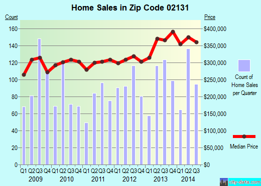
Recent home sales, price trends, and home value evaluator powered by Onboard Informatics
© 2024 Onboard Informatics. Information is deemed reliable but not guaranteed.
© 2024 Onboard Informatics. Information is deemed reliable but not guaranteed.
Some parts © 2024 Advameg, Inc.
Compilation, repackaging, or reproduction prohibited. Users are forewarned that it is incumbent upon them to verify information with the responsible state agency. Advameg, Inc. does not guarantee the data presented is up-to-date nor does it assume responsibility for updating it. Therefore any names, owners or addresses may have changed. Use of any information published here to contact the persons might be prohibited by the law.