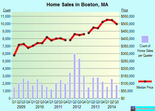
Property valuation of Maple Street, Boston, MA: 1, 2 (tax assessments)
Other nearby streets: Congreve Street (1)  Congreve Street (2)
Congreve Street (3)
Fletcher Street (1)
Fletcher Street (2)
Congreve Street (2)
Congreve Street (3)
Fletcher Street (1)
Fletcher Street (2)
Congreve Street (2)
Congreve Street (3)
Fletcher Street (1)
Fletcher Street (2)
Listed properties vs overall distribution of properties in Boston, MA:
Advertisements
Maple Street
Boston, MA 02132
Find on map >>
Owner: KEVIN P JOHNSON
Occupancy type: Residential Land (Unusable)
Type of property usage: Residential Land
Total assessed land value: $12,100 (it was $12,200 in 2009)
Total assessed value for property: $12,100 (it was $12,200 in 2009)
Millage rate: 258
Parcel's total lotsize: 1,735 square feet
Assessment for tax year: 2014
Maple Street
Boston, MA 02132
Find on map >>
Owner: MATTEO R SELLITTO
Occupancy type: Residential Ancillary Improvement
Type of property usage: Residential Land
Total assessed land value: $40,300 (it was $39,000 in 2009)
Total assessed value for property: $40,300 (it was $39,000 in 2009)
Millage rate: 257
Parcel's total lotsize: 4,312 square feet
Assessment for tax year: 2014
Maple Street
Boston, MA 02132
Find on map >>
Owner: KARIDOYANES STEVEN P
Occupancy type: Residential Land (Unusable)
Type of property usage: Residential Land
Total assessed land value: $6,800 (it was $6,900 in 2009)
Total assessed value for property: $6,800 (it was $6,900 in 2009)
Millage rate: 257
Parcel's total lotsize: 1,000 square feet
Assessment for tax year: 2014
Maple Street
Boston, MA 02132
Find on map >>
Owner: MARIANNE M LEBLANC
Occupancy type: Residential Land (Unusable)
Type of property usage: Residential Land
Total assessed land value: $9,700 (it was $9,800 in 2009)
Total assessed value for property: $9,700 (it was $9,800 in 2009)
Millage rate: 258
Parcel's total lotsize: 1,409 square feet
Assessment for tax year: 2014
Maple Street
Boston, MA 02136
Find on map >>
Owner: MIRLANDE BALAN BALAN
Occupancy type: Residential Land (Unusable)
Type of property usage: Residential Land
Total assessed land value: $19,600 (it was $24,400 in 2009)
Total assessed value for property: $19,600 (it was $24,400 in 2009)
Millage rate: 258
Parcel's total lotsize: 4,128 square feet
Assessment for tax year: 2014
Maple Street
Boston, MA 02132
Find on map >>
Owner: VINCENT BE BERTRAND
Occupancy type: Residential Land (Unusable)
Type of property usage: Residential Land
Total assessed land value: $30,500 (it was $30,700 in 2009)
Total assessed value for property: $30,500 (it was $30,700 in 2009)
Millage rate: 258
Parcel's total lotsize: 4,390 square feet
Assessment for tax year: 2014
Maple Street
Boston, MA 02132
Find on map >>
Owner: EVELYN P TS DOHERTY
Occupancy type: Residential Land (Unusable)
Type of property usage: Residential Land
Total assessed land value: $35,400 (it was $35,600 in 2009)
Total assessed value for property: $35,400 (it was $35,600 in 2009)
Millage rate: 257
Parcel's total lotsize: 5,100 square feet
Assessment for tax year: 2014
Maple Street
Boston, MA 02132
Find on map >>
Owner: CITY OF BOSTON
Occupancy type: City Of Boston
Type of property usage: Tax Exempt
Total assessed land value: $8,100 (it was $9,400 in 2009)
Total assessed value for property: $8,100 (it was $9,400 in 2009)
Parcel's total lotsize: 1,560 square feet
Assessment for tax year: 2014
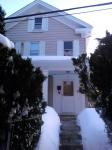
1 Maple Street
Boston, MA 02121
Find on map >>
Owner: KENYA MCDONALD
Occupancy type: Two-Family Dwelling
Type of property usage: Residential Two Family
Total assessed land value: $90,700 (it was $83,640 in 2009)
Total assessed building value: $146,900 (it was $230,435 in 2009)
Total assessed value for property: $237,600 (it was $314,075 in 2009)
Millage rate: 258
Parcel's total lotsize: 3,500 square feet
Year property was built: 1900
Gross floor area of property: 6,633 square feet
Living area of property: 4,305 square feet
Number of levels in a structure: 2.5
Residential building style: Two Family Stack
Roof type of structure: Hip
Exterior finish of structure: Frame/Clapboard
Total number of rooms in structure: 15
Total number of bedrooms in structure: 6
Total number of full bathrooms in structure: 3
Total number of kitchens in structure: 2
Type of heating in structure: Hot Water
Structure has air conditioning: no
Assessment for tax year: 2014
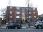
2 Maple Street
Boston, MA 02121
Find on map >>
Owner: PONDEROSA 3331 LLC
Occupancy type: Apt 4-6 Units
Total assessed land value: $122,300 (it was $114,200 in 2009)
Total assessed building value: $343,200 (it was $299,300 in 2009)
Total assessed value for property: $465,500 (it was $413,500 in 2009)
Millage rate: 258
Parcel's total lotsize: 9,477 square feet
Year property was built: 1935
Year property was last remodeled: 1989
Gross floor area of property: 5,887 square feet
Living area of property: 4,040 square feet
Number of levels in a structure: 3
Structural classification: Wood/Frame
Assessment for tax year: 2014
Other nearby streets: Congreve Street (1)
Congreve Street (2)
Congreve Street (3)
Fletcher Street (1)
Fletcher Street (2)
Congreve Street (2)
Congreve Street (3)
Fletcher Street (1)
Fletcher Street (2)

Recent posts about Boston, Massachusetts on our local forum with over 2,400,000 registered users. Boston is mentioned 45,011 times on our forum:
 | Boston (the city) Has Lost Its Allure for Me (141 replies) |
| Is it time to just give up on Boston? (104 replies) |
| "All-Inclusive Boston" campaiagn (582 replies) |
| Boston Racial Stigma- is it "cool" to hate on Boston? (632 replies) |
| Are renters trapped in Boston? (72 replies) |
| How did Boston's Population Plateau According to the Census? (109 replies) |
Settings
X

Recently Added Photos

Boston, MA

Boston, MA

Boston, MA
Boston, MA

Boston, MA

Boston, MA

Boston, MA

Boston, MA
Boston, MA

Boston, MA
Boston, MA

Boston, MA
Request disassociating your name from street-level assessment address

Recent home sales, price trends, and home value evaluator powered by Onboard Informatics
© 2024 Onboard Informatics. Information is deemed reliable but not guaranteed.
© 2024 Onboard Informatics. Information is deemed reliable but not guaranteed.
Some parts © 2024 Advameg, Inc.
Compilation, repackaging, or reproduction prohibited. Users are forewarned that it is incumbent upon them to verify information with the responsible state agency. Advameg, Inc. does not guarantee the data presented is up-to-date nor does it assume responsibility for updating it. Therefore any names, owners or addresses may have changed. Use of any information published here to contact the persons might be prohibited by the law.