Chant (Citrus Heights Association Number Three) neighborhood in Citrus Heights, California (CA), 95621 detailed profile
Settings
X


Business Search - 14 Million verified businesses
Area: 1.343 square miles
Population: 2,599
Population density:
| Chant (Citrus Heights Association Number Three): | 1,935 people per square mile |
| Citrus Heights: | 6,025 people per square mile |

- 1,90870.9%White
- 51519.1%Hispanic or Latino
- 1104.1%Two or more races
- 803.0%Some other race
- 331.2%Black
- 331.2%Asian
- 70.3%American Indian
- 40.1%Native Hawaiian and Other
Pacific Islander

Median household income in 2022:
| Chant (Citrus Heights Association Number Three): | $61,287 |
| Citrus Heights: | $73,923 |
Distribution of median household income
![Distribution of median household income]()
- 56Less than $10,000
- 190$10,000 to $19,999
- 128$20,000 to $29,999
- 117$30,000 to $39,999
- 178$40,000 to $49,999
- 87$50,000 to $59,999
- 131$60,000 to $74,999
- 172$75,000 to $99,999
- 76$100,000 to $124,999
- 169$125,000 to $149,999
- 175$150,000 to $199,999
- 74$200,000 or more

Distribution of owner-occupied house/condo value
![Distribution of owner-occupied house/condo value]()
- 326Less than $50,000
- 333$50,000 to $99,999
- 177$100,000 to $149,999
- 145$150,000 to $199,999
- 156$200,000 to $249,999
- 25$250,000 to $299,999
- 378$300,000 to $399,999
- 166$400,000 to $499,999
- 19$500,000 to $749,999
- 137$750,000 to $999,999
- 17$1,000,000 or more

Distribution of rent paid by renters
![Distribution of rent paid by renters]()
- 227$100 to $199
- 6$200 to $299
- 23$400 to $499
- 185$500 to $599
- 81$700 to $799
- 134$800 to $899
- 91$900 to $999
- 137$1,000 to $1,249
- 73$1,250 to $1,499
- 95$1,500 to $1,999
- 126$2,000 or more

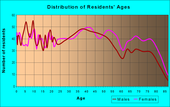
| Males: | 1,154 |
| Females: | 1,444 |
Males:
| This neighborhood: | |
| Whole city: |
| This neighborhood: | 40.3 years |
| Whole city: | 41.2 years |
Average household size:
| Chant (Citrus Heights Association Number Three): | 2.2 people |
| Citrus Heights: | 2.6 people |
Percentage of family households:
| Chant (Citrus Heights Association Number Three): | 34.1% |
| Citrus Heights: | 41.2% |
| Here: | 35.3% |
| Citrus Heights: | 40.8% |
Percentage of married-couple families with children (among all households):
| Chant (Citrus Heights Association Number Three): | 40.9% |
| Citrus Heights: | 28.7% |
Percentage of single-mother households (among all households):
| Chant (Citrus Heights Association Number Three): | 19.8% |
| Citrus Heights: | 6.5% |
Percentage of never married males 15 years old and over:
Percentage of never married females 15 years old and over:
| Chant (Citrus Heights Association Number Three): | 13.6% |
| Citrus Heights: | 19.7% |
Percentage of never married females 15 years old and over:
| Chant (Citrus Heights Association Number Three): | 21.3% |
| city: | 14.3% |
Percentage of people that speak English not well or not at all:
| Chant (Citrus Heights Association Number Three): | 0.8% |
| Citrus Heights: | 4.4% |
Percentage of people born in this state:
Percentage of people born in another U.S. state:
Percentage of native residents but born outside the U.S.:
Percentage of foreign born residents:
| Here: | 57.7% |
| Citrus Heights: | 64.2% |
Percentage of people born in another U.S. state:
| Chant (Citrus Heights Association Number Three): | 20.0% |
| Citrus Heights: | 16.6% |
Percentage of native residents but born outside the U.S.:
| Here: | 0.3% |
| city: | 1.6% |
Percentage of foreign born residents:
| Here: | 22.0% |
| Citrus Heights: | 17.6% |

Owner-occupied
Renter-occupied


- Rooms in owner-occupied houses and condos in Chant <
> - 231 room
- 292 rooms
- 363 rooms
- 2174 rooms
- 1655 rooms
- 4436 rooms
- 1527 rooms
- 668 rooms
- 319+ rooms

- Rooms in renter-occupied apartments in Chant <
> - 721 room
- 372 rooms
- 1533 rooms
- 1404 rooms
- 365 rooms
- 1056 rooms
- 937 rooms
- 688 rooms
- 179+ rooms
Owner-occupied
Renter-occupied

- Bedrooms in owner-occupied houses and condos in Chant <
> - 23no bedroom
- 2151 bedroom
- 4022 bedrooms
- 4363 bedrooms
- 1144 bedrooms
- 425+ bedrooms

- Bedrooms in renter-occupied apartments in Chant <
> - 72no bedroom
- 941 bedroom
- 662 bedrooms
- 1083 bedrooms
- 1944 bedrooms
- 05+ bedrooms
Average number of cars or other vehicles available in houses/condos:
Average number of cars or other vehicles available in apartments:
| This neighborhood: | |
| Citrus Heights: |
Average number of cars or other vehicles available in apartments:
| Here: | 1.5 |
| city: | 1.6 |
Percentage of units with a mortgage:
| Chant (Citrus Heights Association Number Three): | 35.2% |
| Citrus Heights: | 71.2% |

- Year house built in Chant <
> - 02020 or later
- 1282010 to 2019
- 672000 to 2009
- 1051990 to 1999
- 4111980 to 1989
- 4521970 to 1979
- 2891960 to 1969
- 301950 to 1959
- 1021940 to 1949
- 671939 or earlier

City-data.com crime index for city in 2020 (higher means more crime):
| City: | 219.9 |
| U.S. average: | 219.5 |
Travel time to work (commute)
![Travel time to work (commute)]()
- 29Less than 5 minutes
- 995 to 9 minutes
- 17110 to 14 minutes
- 19415 to 19 minutes
- 26720 to 24 minutes
- 12825 to 29 minutes
- 21730 to 34 minutes
- 635 to 39 minutes
- 3940 to 44 minutes
- 10445 to 59 minutes
- 4160 to 89 minutes
- 2290 or more minutes

Means of transportation to work
![Means of transportation to work]()
- 63.0%630Drove a car alone
- 7.3%73Carpooled
- 3.2%32Bus
- 5.4%54Light rail, streetcar or trolley
- 5.0%50Motorcycle
- 11.8%118Bicycle
- 3.5%35Walked
- 4.0%40Other means
- 23.5%235Worked at home

Time leaving home to go to work
![Time leaving home to go to work]()
- 7512:00 a.m. to 4:59 a.m.
- 45:00 a.m. to 5:29 a.m.
- 555:30 a.m. to 5:59 a.m.
- 666:00 a.m. to 6:29 a.m.
- 926:30 a.m. to 6:59 a.m.
- 1987:00 a.m. to 7:29 a.m.
- 1297:30 a.m. to 7:59 a.m.
- 1828:00 a.m. to 8:29 a.m.
- 448:30 a.m. to 8:59 a.m.
- 1569:00 a.m. to 9:59 a.m.
- 7210:00 a.m. to 10:59 a.m.
- 911:00 a.m. to 11:59 a.m.
- 9812:00 p.m. to 3:59 p.m.
- 784:00 p.m. to 11:59 p.m.

Occupations of males:
- Percentage of males in management occupations (except farmers):
Here: 2.1% city: 7.2%
- Percentage of males in arts, design, entertainment, sports, and media occupations:
Here: 1.0% city: 2.0%
- Percentage of males in healthcare practitioners and technical occupations:
Here: 7.8% city: 2.0%
- Percentage of males in service occupations:
Here: 27.2% city: 17.8%
- Percentage of males in sales and office occupations:
Here: 32.0% city: 21.3%
- Percentage of males in production occupations:
Here: 4.6% city: 5.8%
- Percentage of males in transportation occupations:
Here: 6.5% city: 4.8%
- Percentage of males in material moving occupations:
Here: 1.8% city: 5.6%
Occupations of females:
- Percentage of females in management occupations (except farmers):
Here: 8.7% city: 7.3%
- Percentage of females in business and financial operations occupations:
Here: 1.5% city: 7.6%
- Percentage of females in computer and mathematical occupations:
Here: 2.3% city: 1.3%
- Percentage of females in life, physical, and social science occupations:
Here: 2.3% city: 0.9%
- Percentage of females in legal occupations:
Here: 1.6% city: 2.0%
- Percentage of females in education, training, and library occupations:
Here: 4.1% city: 7.8%
- Percentage of females in healthcare practitioners and technical occupations:
Here: 8.4% city: 7.5%
- Percentage of females in service occupations:
Here: 35.1% city: 23.1%
- Percentage of females in sales and office occupations:
Here: 28.9% city: 31.5%
- Percentage of females in production occupations:
Here: 6.7% city: 2.0%
- Percentage of females in transportation occupations:
Here: 1.7% city: 0.8%
Percentage of people 16-64 in Armed Forces:
| Chant (Citrus Heights Association Number Three): | 0.2% |
| Citrus Heights: | 0.2% |
Education in this neighborhood (subdivision or community):
- Percentage of people 3 years and older in K-12 schools:
Chant (Citrus Heights Association Number Three): 25.4% Citrus Heights: 14.7%
- Percentage of people 3 years and older in undergraduate colleges:
Chant (Citrus Heights Association Number Three): 6.0% Citrus Heights: 6.1%
- Percentage of people 3 years and older in grad. or professional schools:
Chant (Citrus Heights Association Number Three): 8.6% Citrus Heights: 1.1%
- Percentage of students K-12 enrolled in private schools:
Chant (Citrus Heights Association Number Three): 78.6% Citrus Heights: 9.0%
Percentage of population below poverty level:
| Chant (Citrus Heights Association Number Three): | 11.7% |
| Citrus Heights: | 10.5% |
Percentage of married-couple families with both working:
| Chant (Citrus Heights Association Number Three): | 85.6% |
| Citrus Heights: | 58.0% |

- 55.8%Utility gas
- 41.0%Electricity
- 1.2%Wood
- 1.2%No fuel used
- 0.9%Bottled, tank, or LP gas
Roads and streets:
Oak Lakes Ln
Length: 1.20 miles
Directions: E-W, N-S, SE-NW, SW-NE
Address range: 6100 to 6499
Directions: E-W, N-S, SE-NW, SW-NE
Address range: 6100 to 6499
Auburn Blvd
Length: 1.13 miles
Direction: SW-NE
Address range: 5900 to 6637
Direction: SW-NE
Address range: 5900 to 6637
Westbrook Dr
Length: 1.05 miles
Directions: E-W, N-S, SE-NW, SW-NE
Address range: 6000 to 6699
Directions: E-W, N-S, SE-NW, SW-NE
Address range: 6000 to 6699
Navion Dr
Length: 0.90 miles
Directions: E-W, N-S, SW-NE
Address range: 6266 to 6799
Directions: E-W, N-S, SW-NE
Address range: 6266 to 6799
Daisy Ln
Length: 0.82 miles
Directions: E-W, N-S, SE-NW, SW-NE
Address range: 6900 to 7199
Directions: E-W, N-S, SE-NW, SW-NE
Address range: 6900 to 7199
Indian River Dr
Length: 0.63 miles
Directions: E-W, N-S, SE-NW, SW-NE
Address range: 6413 to 6744
Directions: E-W, N-S, SE-NW, SW-NE
Address range: 6413 to 6744
Misty Creek Dr
Length: 0.56 miles
Directions: E-W, N-S, SE-NW
Address range: 6500 to 6712
Directions: E-W, N-S, SE-NW
Address range: 6500 to 6712
Willowleaf Dr
Length: 0.48 miles
Directions: E-W, N-S
Address range: 6500 to 6699
Directions: E-W, N-S
Address range: 6500 to 6699
Trailride Way
Length: 0.47 miles
Directions: E-W, N-S, SW-NE
Address range: 6500 to 6999
Directions: E-W, N-S, SW-NE
Address range: 6500 to 6999
Sunburst Way
Length: 0.45 miles
Directions: E-W, N-S, SE-NW
Address range: 6261 to 7079
Directions: E-W, N-S, SE-NW
Address range: 6261 to 7079
Greenback Ln
Length: 0.44 miles
Directions: E-W, SE-NW
Address range: 5959 to 6298
Directions: E-W, SE-NW
Address range: 5959 to 6298
Flaming Arrow Dr
Length: 0.44 miles
Directions: E-W, N-S, SE-NW, SW-NE
Address range: 6600 to 6818
Directions: E-W, N-S, SE-NW, SW-NE
Address range: 6600 to 6818
Skylane Dr
Length: 0.43 miles
Directions: E-W, SE-NW
Address range: 6500 to 6799
Directions: E-W, SE-NW
Address range: 6500 to 6799
Astronaut Ln
Length: 0.43 miles
Direction: E-W
Address range: 6201 to 6299
Direction: E-W
Address range: 6201 to 6299
Shadow Hawk Dr
Length: 0.42 miles
Directions: E-W, N-S, SE-NW, SW-NE
Address range: 6335 to 6599
Directions: E-W, N-S, SE-NW, SW-NE
Address range: 6335 to 6599
Country Ln
Length: 0.42 miles
Directions: E-W, SW-NE
Address range: 5901 to 6299
Directions: E-W, SW-NE
Address range: 5901 to 6299
Summerset Ln
Length: 0.40 miles
Directions: E-W, SE-NW
Address range: 6100 to 6263
Directions: E-W, SE-NW
Address range: 6100 to 6263
Declaration Cir
Length: 0.38 miles
Directions: E-W, SE-NW, SW-NE
Address range: 6000 to 6071
Directions: E-W, SE-NW, SW-NE
Address range: 6000 to 6071
Campfire Way
Length: 0.33 miles
Directions: E-W, SW-NE
Address range: 6501 to 6589
Directions: E-W, SW-NE
Address range: 6501 to 6589
Creekmont Way
Length: 0.33 miles
Directions: E-W, N-S, SW-NE
Address range: 6152 to 6663
Directions: E-W, N-S, SW-NE
Address range: 6152 to 6663
Goldenwood Cir
Length: 0.33 miles
Directions: E-W, N-S, SE-NW, SW-NE
Address range: 6610 to 6739
Directions: E-W, N-S, SE-NW, SW-NE
Address range: 6610 to 6739
Matheny Way
Length: 0.32 miles
Directions: E-W, N-S, SW-NE
Address range: 6200 to 6499
Directions: E-W, N-S, SW-NE
Address range: 6200 to 6499
Trenton Way
Length: 0.31 miles
Directions: E-W, SW-NE
Address range: 6300 to 6499
Directions: E-W, SW-NE
Address range: 6300 to 6499
Cheltenham Way
Length: 0.30 miles
Directions: E-W, N-S, SE-NW
Address range: 6300 to 6499
Directions: E-W, N-S, SE-NW
Address range: 6300 to 6499
Convair Way
Length: 0.30 miles
Directions: N-S, SE-NW
Address range: 7400 to 7499
Directions: N-S, SE-NW
Address range: 7400 to 7499
Radiance Cir
Length: 0.29 miles
Directions: E-W, N-S
Address range: 6901 to 6999
Directions: E-W, N-S
Address range: 6901 to 6999
Melbourne Way
Length: 0.28 miles
Directions: E-W, N-S, SW-NE
Address range: 6500 to 6699
Directions: E-W, N-S, SW-NE
Address range: 6500 to 6699
Sunmist Way
Length: 0.28 miles
Directions: E-W, N-S, SW-NE
Address range: 6211 to 6329
Directions: E-W, N-S, SW-NE
Address range: 6211 to 6329
Hidden Brook Ln
Length: 0.28 miles
Direction: N-S
Address range: 6800 to 6999
Direction: N-S
Address range: 6800 to 6999
Misty Wood Way
Length: 0.25 miles
Direction: E-W
Address range: 6300 to 6375
Direction: E-W
Address range: 6300 to 6375
Shady Springs Way
Length: 0.25 miles
Direction: E-W
Address range: 6324 to 6447
Direction: E-W
Address range: 6324 to 6447
Apache Way
Length: 0.24 miles
Directions: N-S, SE-NW
Address range: 7400 to 7499
Directions: N-S, SE-NW
Address range: 7400 to 7499
Sunwood Way
Length: 0.24 miles
Directions: E-W, N-S, SW-NE
Address range: 7200 to 7322
Directions: E-W, N-S, SW-NE
Address range: 7200 to 7322
Lake Cove Ln
Length: 0.24 miles
Directions: E-W, N-S
Address range: 6800 to 6899
Directions: E-W, N-S
Address range: 6800 to 6899
Tin Wood Way (Twin Wood Way)
Length: 0.23 miles
Direction: E-W
Address range: 6313 to 6427
Direction: E-W
Address range: 6313 to 6427
Pebblebrook Way
Length: 0.22 miles
Directions: E-W, N-S, SE-NW
Address range: 6260 to 7071
Directions: E-W, N-S, SE-NW
Address range: 6260 to 7071
Silkwood Way
Length: 0.22 miles
Directions: E-W, N-S
Address range: 6400 to 6467
Directions: E-W, N-S
Address range: 6400 to 6467
Halifax St
Length: 0.21 miles
Directions: N-S, SE-NW
Address range: 6513 to 6699
Directions: N-S, SE-NW
Address range: 6513 to 6699
Cowboy Way
Length: 0.21 miles
Directions: E-W, SE-NW
Address range: 6500 to 6699
Directions: E-W, SE-NW
Address range: 6500 to 6699
Ranch House Way
Length: 0.21 miles
Directions: N-S, SE-NW
Address range: 6800 to 6999
Directions: N-S, SE-NW
Address range: 6800 to 6999
Imperial Ln
Length: 0.21 miles
Directions: E-W, N-S, SE-NW, SW-NE
Directions: E-W, N-S, SE-NW, SW-NE
Blowing Wind Way
Length: 0.20 miles
Directions: SE-NW, SW-NE
Address range: 6800 to 6899
Directions: SE-NW, SW-NE
Address range: 6800 to 6899
Mossview Way
Length: 0.20 miles
Directions: E-W, N-S, SE-NW
Address range: 6500 to 6558
Directions: E-W, N-S, SE-NW
Address range: 6500 to 6558
Tall Tree Ct (Tall Tree Cir)
Length: 0.20 miles
Directions: E-W, N-S, SW-NE
Address range: 6400 to 6451
Directions: E-W, N-S, SW-NE
Address range: 6400 to 6451
Alden Ln
Length: 0.19 miles
Directions: E-W, N-S, SE-NW
Address range: 6700 to 6799
Directions: E-W, N-S, SE-NW
Address range: 6700 to 6799
Stearman Way
Length: 0.19 miles
Directions: N-S, SE-NW
Address range: 7400 to 7599
Directions: N-S, SE-NW
Address range: 7400 to 7599
Starflower Dr
Length: 0.19 miles
Direction: SE-NW
Address range: 7215 to 7273
Direction: SE-NW
Address range: 7215 to 7273
Twin Park Dr
Length: 0.18 miles
Direction: E-W
Address range: 6500 to 6549
Direction: E-W
Address range: 6500 to 6549
Rock Crest Ln
Length: 0.18 miles
Directions: E-W, N-S, SE-NW, SW-NE
Address range: 6800 to 6899
Directions: E-W, N-S, SE-NW, SW-NE
Address range: 6800 to 6899
Wellsboro Way
Length: 0.18 miles
Directions: N-S, SE-NW, SW-NE
Address range: 6600 to 6699
Directions: N-S, SE-NW, SW-NE
Address range: 6600 to 6699
Saddle Horse Way
Length: 0.18 miles
Direction: N-S
Address range: 6800 to 6999
Direction: N-S
Address range: 6800 to 6999
Blucher Ln
Length: 0.17 miles
Directions: E-W, N-S, SW-NE
Address range: 6100 to 6153
Directions: E-W, N-S, SW-NE
Address range: 6100 to 6153
Freedom Ln
Length: 0.17 miles
Direction: N-S
Address range: 6210 to 6252
Direction: N-S
Address range: 6210 to 6252
Gettysburg Ln
Length: 0.16 miles
Direction: N-S
Address range: 6200 to 6243
Direction: N-S
Address range: 6200 to 6243
Clay Basket Dr
Length: 0.16 miles
Direction: E-W
Address range: 5915 to 6013
Direction: E-W
Address range: 5915 to 6013
Little River Ct
Length: 0.16 miles
Directions: E-W, N-S, SW-NE
Address range: 6400 to 6454
Directions: E-W, N-S, SW-NE
Address range: 6400 to 6454
Grand Tree Ln
Length: 0.15 miles
Directions: N-S, SE-NW, SW-NE
Address range: 6900 to 6999
Directions: N-S, SE-NW, SW-NE
Address range: 6900 to 6999
Devecchi Ave
Length: 0.15 miles
Directions: E-W, SE-NW
Address range: 5920 to 5999
Directions: E-W, SE-NW
Address range: 5920 to 5999
New Creek Ln
Length: 0.15 miles
Directions: N-S, SE-NW, SW-NE
Address range: 6900 to 6999
Directions: N-S, SE-NW, SW-NE
Address range: 6900 to 6999
Gold Oak Ln
Length: 0.15 miles
Directions: E-W, N-S
Address range: 6900 to 6953
Directions: E-W, N-S
Address range: 6900 to 6953
Plymouth Rock Ln
Length: 0.15 miles
Direction: N-S
Address range: 6000 to 6275
Direction: N-S
Address range: 6000 to 6275
Wake Forest Ln
Length: 0.14 miles
Directions: E-W, N-S, SE-NW, SW-NE
Address range: 6923 to 6965
Directions: E-W, N-S, SE-NW, SW-NE
Address range: 6923 to 6965
Broken Bow Dr
Length: 0.14 miles
Directions: E-W, SE-NW
Address range: 5925 to 6029
Directions: E-W, SE-NW
Address range: 5925 to 6029
Bridgemont Way
Length: 0.13 miles
Direction: E-W
Address range: 6600 to 6639
Direction: E-W
Address range: 6600 to 6639
Tandy Ln
Length: 0.13 miles
Directions: N-S, SE-NW
Address range: 6800 to 6899
Directions: N-S, SE-NW
Address range: 6800 to 6899
Ranch Hand Way
Length: 0.13 miles
Directions: E-W, SE-NW
Address range: 6500 to 6599
Directions: E-W, SE-NW
Address range: 6500 to 6599
Grosse Point Ct
Length: 0.12 miles
Direction: N-S
Address range: 6600 to 6654
Direction: N-S
Address range: 6600 to 6654
Silver Springs Ln (Silver Springs Ct)
Length: 0.12 miles
Direction: N-S
Address range: 6600 to 6699
Direction: N-S
Address range: 6600 to 6699
Lake Tree Ln
Length: 0.12 miles
Directions: E-W, N-S, SW-NE
Address range: 6900 to 6955
Directions: E-W, N-S, SW-NE
Address range: 6900 to 6955
Voyager Way
Length: 0.11 miles
Directions: N-S, SE-NW
Address range: 7400 to 7499
Directions: N-S, SE-NW
Address range: 7400 to 7499
Oak Branch Ct
Length: 0.11 miles
Directions: E-W, SW-NE
Address range: 6600 to 6699
Directions: E-W, SW-NE
Address range: 6600 to 6699
Mame Ct
Length: 0.10 miles
Direction: E-W
Address range: 6100 to 6137
Direction: E-W
Address range: 6100 to 6137
Big Arrow Ct
Length: 0.10 miles
Directions: E-W, SW-NE
Address range: 6900 to 6947
Directions: E-W, SW-NE
Address range: 6900 to 6947
Meiggs Ct
Length: 0.09 miles
Direction: E-W
Address range: 6100 to 6132
Direction: E-W
Address range: 6100 to 6132
Silversaddle Way
Length: 0.09 miles
Directions: N-S, SW-NE
Directions: N-S, SW-NE
Panorama Dr
Length: 0.09 miles
Directions: E-W, N-S, SE-NW
Directions: E-W, N-S, SE-NW
Small Hill Ct
Length: 0.09 miles
Directions: E-W, SW-NE
Address range: 5900 to 5924
Directions: E-W, SW-NE
Address range: 5900 to 5924
Wonner Way
Length: 0.09 miles
Direction: N-S
Address range: 7000 to 7117
Direction: N-S
Address range: 7000 to 7117
Oak Bend Way
Length: 0.09 miles
Direction: E-W
Address range: 6500 to 6549
Direction: E-W
Address range: 6500 to 6549
Imperial Way
Length: 0.09 miles
Direction: SE-NW
Address range: 5800 to 5999
Direction: SE-NW
Address range: 5800 to 5999
Kate Ln
Length: 0.09 miles
Direction: SE-NW
Address range: 6700 to 6736
Direction: SE-NW
Address range: 6700 to 6736
Revolution Ln
Length: 0.08 miles
Direction: E-W
Direction: E-W
Foxwood Ct
Length: 0.08 miles
Direction: N-S
Address range: 6648 to 6682
Direction: N-S
Address range: 6648 to 6682
Webster Ln
Length: 0.08 miles
Directions: E-W, N-S, SW-NE
Address range: 6200 to 6294
Directions: E-W, N-S, SW-NE
Address range: 6200 to 6294
Chatham Way
Length: 0.08 miles
Directions: E-W, SE-NW
Address range: 6600 to 6699
Directions: E-W, SE-NW
Address range: 6600 to 6699
Walking Stick Ct
Length: 0.08 miles
Directions: E-W, SE-NW, SW-NE
Address range: 5900 to 5943
Directions: E-W, SE-NW, SW-NE
Address range: 5900 to 5943
Broken Arrow Ct
Length: 0.08 miles
Direction: E-W
Address range: 6000 to 6801
Direction: E-W
Address range: 6000 to 6801
Shamus Ct
Length: 0.07 miles
Direction: N-S
Address range: 6600 to 6635
Direction: N-S
Address range: 6600 to 6635
Galaxy Ct
Length: 0.07 miles
Direction: N-S
Address range: 6600 to 6635
Direction: N-S
Address range: 6600 to 6635
Dawn View Ct
Length: 0.07 miles
Directions: E-W, N-S, SE-NW
Address range: 7100 to 7133
Directions: E-W, N-S, SE-NW
Address range: 7100 to 7133
Piper Ct
Length: 0.07 miles
Direction: SW-NE
Address range: 6700 to 6799
Direction: SW-NE
Address range: 6700 to 6799
Tall Brave Ct
Length: 0.07 miles
Directions: E-W, SE-NW
Address range: 6000 to 6038
Directions: E-W, SE-NW
Address range: 6000 to 6038
Moon Rock Way
Length: 0.06 miles
Direction: E-W
Address range: 5900 to 5999
Direction: E-W
Address range: 5900 to 5999
Stinson Way
Length: 0.06 miles
Direction: N-S
Address range: 7300 to 7399
Direction: N-S
Address range: 7300 to 7399
Brokenfeather Way (Broken Feather Way)
Length: 0.06 miles
Direction: E-W
Address range: 6000 to 6099
Direction: E-W
Address range: 6000 to 6099
Appleby Way
Length: 0.06 miles
Directions: E-W, SW-NE
Address range: 6200 to 6299
Directions: E-W, SW-NE
Address range: 6200 to 6299
Horseman Way
Length: 0.06 miles
Direction: E-W
Direction: E-W
Cardigan Ct
Length: 0.06 miles
Directions: E-W, SE-NW
Address range: 6200 to 6299
Directions: E-W, SE-NW
Address range: 6200 to 6299
Fire Water Ct
Length: 0.05 miles
Directions: E-W, SE-NW
Address range: 5900 to 5929
Directions: E-W, SE-NW
Address range: 5900 to 5929
Fire Stick Ct
Length: 0.05 miles
Direction: E-W
Address range: 5900 to 5917
Direction: E-W
Address range: 5900 to 5917
Van Maren Ln
Length: 0.05 miles
Direction: N-S
Address range: 7601 to 7699
Direction: N-S
Address range: 7601 to 7699
Dewdrop Way
Length: 0.05 miles
Direction: N-S
Address range: 7300 to 7334
Direction: N-S
Address range: 7300 to 7334
Barnwood Ct
Length: 0.05 miles
Directions: E-W, SE-NW
Address range: 6500 to 6599
Directions: E-W, SE-NW
Address range: 6500 to 6599
Pretty Girl Ct
Length: 0.05 miles
Directions: N-S, SE-NW
Address range: 6400 to 6499
Directions: N-S, SE-NW
Address range: 6400 to 6499
Papoose Ct
Length: 0.05 miles
Direction: E-W
Address range: 5900 to 5918
Direction: E-W
Address range: 5900 to 5918
Little Squaw Ct
Length: 0.05 miles
Directions: E-W, N-S, SE-NW
Address range: 5925 to 5999
Directions: E-W, N-S, SE-NW
Address range: 5925 to 5999
Pretty Bush Ct
Length: 0.05 miles
Direction: E-W
Address range: 5900 to 5999
Direction: E-W
Address range: 5900 to 5999
Springleaf Ct
Length: 0.05 miles
Directions: N-S, SW-NE
Address range: 6244 to 7221
Directions: N-S, SW-NE
Address range: 6244 to 7221
Mi Ct
Length: 0.05 miles
Directions: N-S, SE-NW
Address range: 6500 to 6518
Directions: N-S, SE-NW
Address range: 6500 to 6518
Running Water Ct
Length: 0.05 miles
Directions: E-W, SE-NW
Address range: 5916 to 5939
Directions: E-W, SE-NW
Address range: 5916 to 5939
White Cloud Ct
Length: 0.04 miles
Directions: E-W, SE-NW
Address range: 6019 to 6087
Directions: E-W, SE-NW
Address range: 6019 to 6087
High Sun Ct
Length: 0.04 miles
Direction: SW-NE
Address range: 6800 to 6833
Direction: SW-NE
Address range: 6800 to 6833
Hillspire Ct
Length: 0.04 miles
Direction: SW-NE
Address range: 6445 to 6465
Direction: SW-NE
Address range: 6445 to 6465
Caywood Ct
Length: 0.04 miles
Direction: N-S
Address range: 6826 to 6852
Direction: N-S
Address range: 6826 to 6852
Tanbark Ct
Length: 0.04 miles
Directions: E-W, SE-NW
Address range: 6300 to 6321
Directions: E-W, SE-NW
Address range: 6300 to 6321
Oak Valley Ln
Length: 0.04 miles
Directions: N-S, SW-NE
Directions: N-S, SW-NE
Lasso Ct
Length: 0.04 miles
Direction: SE-NW
Address range: 6700 to 6799
Direction: SE-NW
Address range: 6700 to 6799
Woodenfield Ct
Length: 0.04 miles
Directions: N-S, SW-NE
Address range: 6600 to 6699
Directions: N-S, SW-NE
Address range: 6600 to 6699
Dancing Creek Ct
Length: 0.04 miles
Direction: N-S
Address range: 7100 to 7119
Direction: N-S
Address range: 7100 to 7119
Hill Shade Ct
Length: 0.04 miles
Direction: SE-NW
Address range: 5800 to 5899
Direction: SE-NW
Address range: 5800 to 5899
Little Beaver Way
Length: 0.03 miles
Direction: E-W
Direction: E-W
Derby Ct
Length: 0.03 miles
Direction: SE-NW
Address range: 6600 to 6699
Direction: SE-NW
Address range: 6600 to 6699
Woodendale Ct
Length: 0.03 miles
Direction: SW-NE
Address range: 6600 to 6699
Direction: SW-NE
Address range: 6600 to 6699
Treetop Ct
Length: 0.03 miles
Direction: N-S
Address range: 7100 to 7115
Direction: N-S
Address range: 7100 to 7115
Brantford Way
Length: 0.03 miles
Direction: E-W
Address range: 6200 to 6299
Direction: E-W
Address range: 6200 to 6299
Sudden Wind Ct
Length: 0.03 miles
Direction: SW-NE
Address range: 6500 to 6599
Direction: SW-NE
Address range: 6500 to 6599
Redskin Ct
Length: 0.03 miles
Direction: SE-NW
Address range: 6000 to 6099
Direction: SE-NW
Address range: 6000 to 6099
Hidden Stream Ln (Hidden Stream Ct)
Length: 0.03 miles
Direction: E-W
Address range: 6310 to 6319
Direction: E-W
Address range: 6310 to 6319
Glen Hollow Ct
Length: 0.03 miles
Direction: N-S
Address range: 6638 to 6660
Direction: N-S
Address range: 6638 to 6660
Little Arrow Ct
Length: 0.03 miles
Direction: E-W
Address range: 5900 to 5999
Direction: E-W
Address range: 5900 to 5999
Fast Water Ct
Length: 0.03 miles
Direction: SW-NE
Address range: 6514 to 6532
Direction: SW-NE
Address range: 6514 to 6532
Twin Brook Ct
Length: 0.03 miles
Direction: N-S
Address range: 7126 to 7145
Direction: N-S
Address range: 7126 to 7145
Mugho Ct
Length: 0.03 miles
Direction: E-W
Address range: 6300 to 6315
Direction: E-W
Address range: 6300 to 6315
Woodbrook Ct
Length: 0.03 miles
Direction: SW-NE
Address range: 5800 to 5829
Direction: SW-NE
Address range: 5800 to 5829
Rebel Cir
Length: 0.03 miles
Directions: E-W, SW-NE
Directions: E-W, SW-NE
Silk Oak Ct
Length: 0.03 miles
Directions: E-W, SE-NW
Address range: 6400 to 6421
Directions: E-W, SE-NW
Address range: 6400 to 6421
Ironback Ct (Ironbark Ct)
Length: 0.03 miles
Direction: E-W
Address range: 6200 to 6311
Direction: E-W
Address range: 6200 to 6311
Maranta Ct
Length: 0.02 miles
Direction: E-W
Address range: 6300 to 6312
Direction: E-W
Address range: 6300 to 6312
Rollingside Ct
Length: 0.02 miles
Direction: N-S
Address range: 7124 to 7145
Direction: N-S
Address range: 7124 to 7145
Tree Hill Ct
Length: 0.02 miles
Direction: SW-NE
Address range: 5800 to 5899
Direction: SW-NE
Address range: 5800 to 5899
Other features:
Cripple Crk
Length: 2.79 miles
Directions: E-W, N-S, SE-NW, SW-NE
Directions: E-W, N-S, SE-NW, SW-NE
Arcade Crk
Length: 1.00 miles
Directions: E-W, N-S, SE-NW, SW-NE
Directions: E-W, N-S, SE-NW, SW-NE