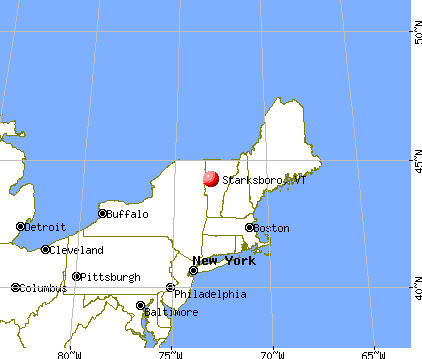
Starksboro, Vermont
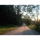
Submit your own pictures of this town and show them to the world
- OSM Map
- General Map
- Google Map
- MSN Map

Population change since 2000: -6.4%
 |
| Males: 912 | |
| Females: 865 |
| Median resident age: | 40.2 years |
| Vermont median age: | 45.8 years |
Zip codes: 05487.
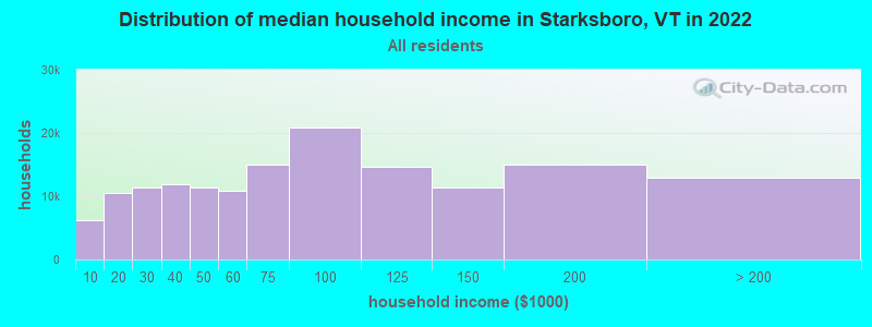
| Starksboro: | $88,663 |
| VT: | $73,991 |
Estimated per capita income in 2022: $38,791 (it was $17,688 in 2000)
Starksboro town income, earnings, and wages data
Estimated median house or condo value in 2022: $309,756 (it was $103,400 in 2000)
| Starksboro: | $309,756 |
| VT: | $304,700 |
Mean prices in 2022: all housing units: $400,302; detached houses: $427,258; townhouses or other attached units: $389,241; in 2-unit structures: $373,341; in 3-to-4-unit structures: $633,103; in 5-or-more-unit structures: $292,995; mobile homes: $101,709
Detailed information about poverty and poor residents in Starksboro, VT

Compare current foreclosures near Starksboro, VT:
| Photo | Address | Area | Beds / Baths | Price | Details |
|---|---|---|---|---|---|

|
#1
Vt Route 116
Starksboro, VT 05487
|
- sq. feet
|
- baths - beds |
show details | |

|
#2
Route 116
Starksboro, VT 05487
|
- sq. feet
|
- baths - beds |
show details | |

|
#3
Lazy Brook Dr
Starksboro, VT 05487
|
- sq. feet
|
- baths - beds |
show details | |

|
#4
Jourdan St
Hinesburg, VT 05461
|
- sq. feet
|
- baths - beds |
show details | |

|
#5
Crossett Hl Unit 3
Waterbury, VT 05676
|
- sq. feet
|
- baths - beds |
show details | |

|
#6
Rabbit Hollow Rd
Northfield, VT 05663
|
- sq. feet
|
- baths - beds |
show details | |

|
#7
Armory Ln Apt 201
Vergennes, VT 05491
|
- sq. feet
|
- baths - beds |
show details | |

|
#8
Pine St # 4
Bristol, VT 05443
|
- sq. feet
|
- baths - beds |
show details | |

|
#9
N Meadow Dr
Bristol, VT 05443
|
- sq. feet
|
- baths - beds |
show details | |

|
#10
Eagles Rd
Waitsfield, VT 05673
|
- sq. feet
|
- baths - beds |
show details |
| Photo | Address | Area | Beds / Baths | Price | Details |
|---|---|---|---|---|---|

|
#11
Plank Rd
Vergennes, VT 05491
|
- sq. feet
|
- baths - beds |
show details | |

|
#12
Henrys Way
Ferrisburg, VT 05456
|
- sq. feet
|
- baths - beds |
show details | |

|
#13
S Maple St
Vergennes, VT 05491
|
- sq. feet
|
- baths - beds |
show details | |

|
#14
Willowbrook Ln
Williston, VT 05495
|
- sq. feet
|
- baths - beds |
show details | |

|
#15
Esplanade
Richmond, VT 05477
|
- sq. feet
|
- baths - beds |
show details | |

|
#16
Hardscrabble Rd
Bristol, VT 05443
|
- sq. feet
|
- baths - beds |
show details | |

|
#17
Duxfarm Ests
Waterbury, VT 05676
|
- sq. feet
|
- baths - beds |
show details | |

|
#18
Stage Rd
Jericho, VT 05465
|
- sq. feet
|
- baths - beds |
show details | |

|
#19
Village Grv
Williston, VT 05495
|
- sq. feet
|
- baths - beds |
show details | |

|
Check over 1 million property listings on Foreclosure.com!
|
browse all offers | |||

- 1,72397.0%White alone
- 231.3%Two or more races
- 140.8%Asian alone
- 100.6%Hispanic
- 40.2%Other race alone
- 20.1%Black alone
- 10.06%American Indian alone

Races in Starksboro detailed stats: ancestries, foreign born residents, place of birth
According to our research of Vermont and other state lists, there were 4 registered sex offenders living in Starksboro, Vermont as of June 01, 2024.
The ratio of all residents to sex offenders in Starksboro is 444 to 1.
The ratio of registered sex offenders to all residents in this city is near the state average.
 Recent articles from our blog. Our writers, many of them Ph.D. graduates or candidates, create easy-to-read articles on a wide variety of topics.

 | Vermont Retirement Planning: Tell me what I DON'T know about Vermont (95 replies) |
| Yet another moving to Vermont thread - Burlington or Montpelier area (27 replies) |
| Areas of Vermont for a single male who wants to be alone? (27 replies) |
| Need Advice. May move to Burlington for a Job (9 replies) |
| Accessing nature (22 replies) |
| Winter Road Conditions (relocating to Burlington) (4 replies) |
Latest news from Starksboro, VT collected exclusively by city-data.com from local newspapers, TV, and radio stations
Ancestries: Irish (18.0%), English (15.3%), French (13.7%), German (11.3%), United States (11.2%), French Canadian (6.0%).
Current Local Time: EST time zone
Elevation: 615 feet
Land area: 45.5 square miles.
Population density: 39 people per square mile (very low).
35 residents are foreign born
| This town: | 1.8% |
| Vermont: | 3.8% |
| Starksboro town: | 1.8% ($1,889) |
| Vermont: | 2.0% ($2,196) |
Nearest city with pop. 50,000+: Schenectady, NY  (107.2 miles , pop. 61,821).
Nearest city with pop. 200,000+: Boston, MA (162.6 miles , pop. 589,141).
Nearest city with pop. 1,000,000+: Bronx, NY (236.4 miles , pop. 1,332,650).
Nearest cities:
), ), ), Latitude: 44.21 N, Longitude: 73.02 W
Area code commonly used in this area: 802

Single-family new house construction building permits:
- 2022: 4 buildings, average cost: $279,200
- 2021: 10 buildings, average cost: $282,200
- 2020: 8 buildings, average cost: $282,200
- 2019: 7 buildings, average cost: $282,200
- 2018: 5 buildings, average cost: $249,800
- 2017: 2 buildings, average cost: $267,800
- 2016: 5 buildings, average cost: $246,000
- 2015: 7 buildings, average cost: $257,200
- 2014: 5 buildings, average cost: $211,200
- 2013: 4 buildings, average cost: $193,300
- 2012: 1 building, cost: $184,000
- 2011: 1 building, cost: $220,300
- 2010: 7 buildings, average cost: $165,900
- 2009: 2 buildings, average cost: $178,900
- 2008: 9 buildings, average cost: $182,400
- 2007: 5 buildings, average cost: $181,200
- 2006: 6 buildings, average cost: $171,000
- 2005: 14 buildings, average cost: $150,200
- 2004: 6 buildings, average cost: $138,800
- 2003: 3 buildings, average cost: $132,800
- 2002: 9 buildings, average cost: $130,700
- 2001: 1 building, cost: $121,400
- 2000: 9 buildings, average cost: $118,000
- 1999: 13 buildings, average cost: $109,200
- 1998: 8 buildings, average cost: $82,800
- 1997: 7 buildings, average cost: $82,800


| Here: | 1.7% |
| Vermont: | 2.0% |


- Educational services (13.5%)
- Construction (9.8%)
- Health care (8.6%)
- Professional, scientific, technical services (5.1%)
- Computer & electronic products (3.9%)
- Food & beverage stores (3.6%)
- Public administration (3.3%)

- Construction (17.9%)
- Educational services (6.8%)
- Computer & electronic products (6.7%)
- Professional, scientific, technical services (5.2%)
- Agriculture, forestry, fishing & hunting (3.9%)
- Building material & garden equipment & supplies dealers (3.9%)
- Accommodation & food services (3.5%)

- Educational services (20.8%)
- Health care (14.6%)
- Food & beverage stores (5.2%)
- Professional, scientific, technical services (4.9%)
- Social assistance (4.9%)
- Public administration (3.9%)
- Religious, grantmaking, civic, professional, similar organizations (3.3%)

- Other production occupations, including supervisors (4.8%)
- Other sales and related occupations, including supervisors (4.8%)
- Material recording, scheduling, dispatching, and distributing workers (4.7%)
- Building and grounds cleaning and maintenance occupations (3.5%)
- Other management occupations, except farmers and farm managers (3.3%)
- Retail sales workers, except cashiers (3.2%)
- Registered nurses (2.9%)

- Other production occupations, including supervisors (6.1%)
- Driver/sales workers and truck drivers (5.4%)
- Carpenters (4.4%)
- Material recording, scheduling, dispatching, and distributing workers (4.4%)
- Other management occupations, except farmers and farm managers (4.1%)
- Other sales and related occupations, including supervisors (4.1%)
- Engineers (3.9%)

- Registered nurses (6.2%)
- Other sales and related occupations, including supervisors (5.6%)
- Material recording, scheduling, dispatching, and distributing workers (4.9%)
- Preschool, kindergarten, elementary, and middle school teachers (4.7%)
- Other office and administrative support workers, including supervisors (4.3%)
- Child care workers (4.3%)
- Other teachers, instructors, education, training, and library occupations (4.3%)
Average climate in Starksboro, Vermont
Based on data reported by over 4,000 weather stations


(lower is better)

Air Quality Index (AQI) level in 2022 was 56.4. This is better than average.
| City: | 56.4 |
| U.S.: | 72.6 |

Carbon Monoxide (CO) [ppm] level in 2022 was 0.00585. This is significantly better than average. Closest monitor was 21.0 miles away from the city center.
| City: | 0.00585 |
| U.S.: | 0.25132 |

Nitrogen Dioxide (NO2) [ppb] level in 2021 was 4.81. This is about average. Closest monitor was 21.0 miles away from the city center.
| City: | 4.81 |
| U.S.: | 5.11 |

Sulfur Dioxide (SO2) [ppb] level in 2022 was 0.0619. This is significantly better than average. Closest monitor was 21.0 miles away from the city center.
| City: | 0.0619 |
| U.S.: | 1.5147 |

Ozone [ppb] level in 2022 was 34.8. This is about average. Closest monitor was 18.9 miles away from the city center.
| City: | 34.8 |
| U.S.: | 33.3 |

Particulate Matter (PM2.5) [µg/m3] level in 2022 was 5.83. This is better than average. Closest monitor was 21.0 miles away from the city center.
| City: | 5.83 |
| U.S.: | 8.11 |
Earthquake activity:
Starksboro-area historical earthquake activity is significantly above Vermont state average. It is 71% smaller than the overall U.S. average.On 4/20/2002 at 10:50:47, a magnitude 5.3 (5.3 ML, Depth: 3.0 mi, Class: Moderate, Intensity: VI - VII) earthquake occurred 39.7 miles away from the city center
On 4/20/2002 at 10:50:47, a magnitude 5.2 (5.2 MB, 4.2 MS, 5.2 MW, 5.0 MW) earthquake occurred 39.7 miles away from Starksboro center
On 10/7/1983 at 10:18:46, a magnitude 5.3 (5.1 MB, 5.3 LG, 5.1 ML) earthquake occurred 68.1 miles away from the city center
On 1/19/1982 at 00:14:42, a magnitude 4.7 (4.5 MB, 4.7 MD, 4.5 LG, Class: Light, Intensity: IV - V) earthquake occurred 85.9 miles away from the city center
On 10/16/2012 at 23:12:25, a magnitude 4.7 (4.7 ML, Depth: 10.0 mi) earthquake occurred 125.0 miles away from Starksboro center
On 6/16/1995 at 12:13:11, a magnitude 3.8 (3.8 LG, Depth: 3.1 mi, Class: Light, Intensity: II - III) earthquake occurred 54.9 miles away from Starksboro center
Magnitude types: regional Lg-wave magnitude (LG), body-wave magnitude (MB), duration magnitude (MD), local magnitude (ML), surface-wave magnitude (MS), moment magnitude (MW)
Natural disasters:
The number of natural disasters in Addison County (23) is greater than the US average (15).Major Disasters (Presidential) Declared: 16
Emergencies Declared: 3
Causes of natural disasters: Floods: 16, Storms: 15, Drought: 1, Heavy Rain: 1, Hurricane: 1, Ice Storm: 1, Landslide: 1, Snow: 1, Snowstorm: 1, Tornado: 1, Tropical Storm: 1, Wind: 1, Winter Storm: 1, Other: 1 (Note: some incidents may be assigned to more than one category).

Hospitals and medical centers near Starksboro:
- CLARK NURSING HOME (Nursing Home, about 12 miles away; VERGENNES, VT)
- WAKE ROBIN-LINDEN NURSING HOME (Nursing Home, about 16 miles away; SHELBURNE, VT)
- VERMONT STATE HOSP (Hospital, about 16 miles away; WATERBURY, VT)
- VERMONT STATE HOSP DISTINCT PART UNIT (Hospital, about 16 miles away; WATERBURY, VT)
- VERMONT STATE NURSING HOME (Nursing Home, about 16 miles away; WATERBURY, VT)
Colleges/universities with over 2000 students nearest to Starksboro:
- Middlebury College (about 16 miles; Middlebury, VT; Full-time enrollment: 3,077)
- Norwich University (about 19 miles; Northfield, VT; FT enrollment: 4,221)
- Champlain College (about 21 miles; Burlington, VT; FT enrollment: 2,623)
- University of Vermont (about 21 miles; Burlington, VT; FT enrollment: 11,566)
- Saint Michael's College (about 22 miles; Colchester, VT; FT enrollment: 2,336)
- Community College of Vermont (about 22 miles; Winooski, VT; FT enrollment: 3,394)
- SUNY College at Plattsburgh (about 41 miles; Plattsburgh, NY; FT enrollment: 5,934)
Public elementary/middle school in Starksboro:
- ROBINSON SCHOOL (Students: 147, Location: 41 PARSONAGE ROAD, Grades: PK-6)
Points of interest:
Notable locations in Starksboro: Starksboro Volunteer Fire Department Station 2 (A), Starksboro Volunteer Fire Department Station 1 (B). Display/hide their locations on the map
Churches in Starksboro include: Starksboro Village Meeting House (A), Friends Church (B). Display/hide their locations on the map
Cemeteries: Jerusalem Cemetery (1), Little Ireland Cemetery (2), South Starksboro Friends Cemetery (3), Butler Cemetery (4), Taft Cemetery (5), Village Cemetery (6), Green Mount Cemetery (7). Display/hide their locations on the map
Lake: Baldwin Pond (A). Display/hide its location on the map
Streams, rivers, and creeks: Stave Brook (A), Hollow Brook (B), Beaver Meadow Brook (C), Bakers Brook (D), Hallock Brook (E). Display/hide their locations on the map
Drinking water stations with addresses in Starksboro and their reported violations in the past:
CAMP COMMON GROUND (Address: 473 TATRO ROAD , Population served: 154, Groundwater):Past health violations:STARKSBORO VILLAGE WATER COOP (Address: 102 BIG HOLLOW RD , Population served: 150, Groundwater):
- MCL, Monthly (TCR) - In OCT-2011, Contaminant: Coliform. Follow-up actions: St Tech Assistance Visit (OCT-17-2011), St Formal NOV issued (OCT-17-2011), St Public Notif requested (OCT-17-2011), St Boil Water Order (OCT-17-2011), St Compliance achieved (FEB-11-2013)
Past monitoring violations:WILCOX COVE GOLF COURSE CABINS (Address: 6686 VT RTE 116 , Population served: 53, Groundwater):
- One regular monitoring violation
Past monitoring violations:
- One regular monitoring violation
| This town: | 2.5 people |
| Vermont: | 2.3 people |
| This town: | 68.5% |
| Whole state: | 62.5% |
| This town: | 10.0% |
| Whole state: | 9.2% |
Likely homosexual households (counted as self-reported same-sex unmarried-partner households)
- Lesbian couples: 0.6% of all households
- Gay men: 0.3% of all households
| This town: | 9.8% |
| Whole state: | 9.4% |
| This town: | 4.4% |
| Whole state: | 3.6% |
For population 15 years and over in Starksboro:

- Never married: 25.5%
- Now married: 59.3%
- Separated: 1.1%
- Widowed: 3.1%
- Divorced: 11.0%
For population 25 years and over in Starksboro:
- High school or higher: 85.1%
- Bachelor's degree or higher: 31.4%
- Graduate or professional degree: 9.6%
- Unemployed: 2.7%
- Mean travel time to work (commute): 32.1 minutes


| Here: | 11.8 |
| Vermont average: | 11.7 |
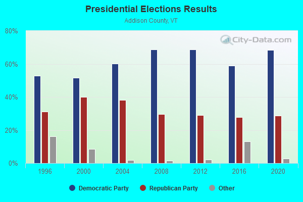
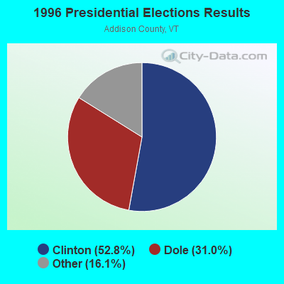

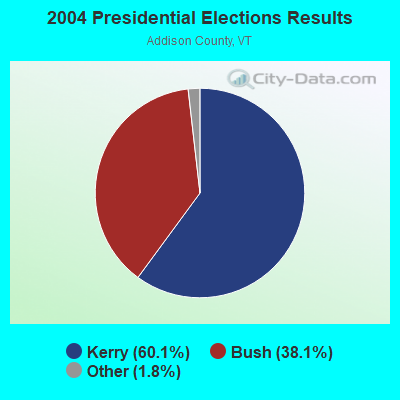
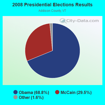
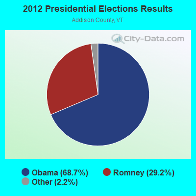
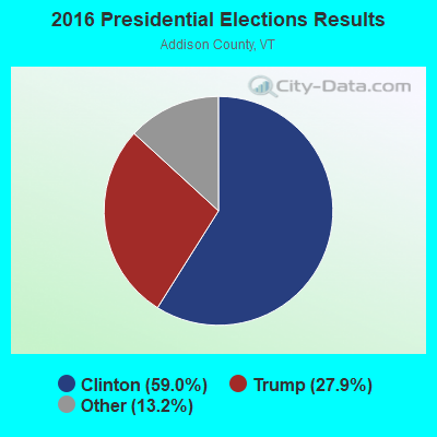
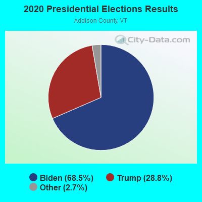
Graphs represent county-level data. Detailed 2008 Election Results
Religion statistics for Starksboro, VT (based on Addison County data)
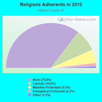
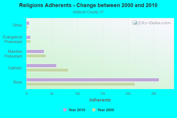
| Religion | Adherents | Congregations |
|---|---|---|
| Catholic | 5,892 | 6 |
| Mainline Protestant | 3,491 | 27 |
| Evangelical Protestant | 801 | 13 |
| Other | 560 | 6 |
| None | 26,077 | - |
Food Environment Statistics:
| Addison County: | 4.64 / 10,000 pop. |
| Vermont: | 3.84 / 10,000 pop. |
| Addison County: | 1.36 / 10,000 pop. |
| Vermont: | 1.95 / 10,000 pop. |
| Addison County: | 6.55 / 10,000 pop. |
| State: | 6.40 / 10,000 pop. |
| This county: | 8.45 / 10,000 pop. |
| Vermont: | 11.52 / 10,000 pop. |
| This county: | 5.8% |
| Vermont: | 6.8% |
| Addison County: | 20.9% |
| Vermont: | 22.3% |
| Here: | 9.1% |
| Vermont: | 13.3% |
Strongest AM radio stations in Starksboro:
- WDEV (550 AM; 5 kW; WATERBURY, VT; Owner: RADIO VERMONT, INC.)
- WCHP (760 AM; 35 kW; CHAMPLAIN, NY; Owner: CHAMPLAIN RADIO, INC.)
- WVMT (620 AM; 5 kW; BURLINGTON, VT; Owner: SISON BROADCASTING, INC.)
- WVAA (1390 AM; 5 kW; BURLINGTON, VT; Owner: RADIO VERMONT, KDR, LLC)
- WICY (1490 AM; 50 kW; MALONE, NY; Owner: CARTIER COMMUNICATIONS INC.)
- WGY (810 AM; 50 kW; SCHENECTADY, NY; Owner: CLEAR CHANNEL BROADCASTING LICENSES, INC.)
- WEAV (960 AM; 5 kW; PLATTSBURGH, NY; Owner: CLEAR CHANNEL BROADCASTING LICENSES, INC.)
- WTWK (1070 AM; daytime; 5 kW; PLATTSBURGH, NY; Owner: CHAMPLAIN COMMUNICATIONS CORPORATION)
- WNNZ (640 AM; 50 kW; WESTFIELD, MA; Owner: CLEAR CHANNEL BROADCASTING LICENSES, INC.)
- WRKO (680 AM; 50 kW; BOSTON, MA; Owner: ENTERCOM BOSTON LICENSE, LLC)
- WCRN (830 AM; 50 kW; WORCESTER, MA; Owner: CARTER BROADCASTING CORPORATION)
- WPTR (1540 AM; 50 kW; ALBANY, NY; Owner: KIMTRON, INC.)
- WFAD (1490 AM; 1 kW; MIDDLEBURY, VT; Owner: ADDISON BROADCASTING COMPANY, INC.)
Strongest FM radio stations in Starksboro:
- WDEV-FM (96.1 FM; WARREN, VT; Owner: RADIO VERMONT, INC.)
- WCVT (101.7 FM; STOWE, VT; Owner: RADIO VERMONT CLASSICS, L.L.C.)
- WNCS (104.7 FM; MONTPELIER, VT; Owner: MONTPELIER BROADCASTING, INC.)
- WVPS (107.9 FM; BURLINGTON, VT; Owner: VERMONT PUBLIC RADIO)
- WEZF (92.9 FM; BURLINGTON, VT; Owner: CAPSTAR TX LIMITED PARTNERSHIP)
- WLKC (103.3 FM; WATERBURY, VT; Owner: RADIO BROADCASTING SERVICES, INC.)
- WGLY-FM (91.5 FM; BOLTON, VT; Owner: CHRISTIAN MINISTRIES, INC.)
- WIZN (106.7 FM; VERGENNES, VT; Owner: BURLINGTON BROADCASTERS, INC.)
- WXZO (96.7 FM; WILLSBORO, NY; Owner: CAPSTAR TX LIMITED PARTNERSHIP)
- WWFY (100.9 FM; BERLIN, VT; Owner: VOX ALLEGANY, LLC)
- WEBK (105.3 FM; KILLINGTON, VT; Owner: 6 JOHNSON ROAD LICENSES, INC.)
- WJJR (98.1 FM; RUTLAND, VT; Owner: 6 JOHNSON ROAD LICENSES, INC.)
- WZRT (97.1 FM; RUTLAND, VT; Owner: CAPSTAR TX LIMITED PARTNERSHIP)
- WGLV (91.7 FM; WOODSTOCK, VT; Owner: CHRISTIAN MINISTRIES INC)
- WHDQ-FM1 (106.1 FM; RUTLAND, VT; Owner: GREAT NORTHERN RADIO, L.L.C.)
- WEXP (101.5 FM; BRANDON, VT; Owner: VOX VERMONT, L.L.C.)
- WJEN (94.5 FM; RUTLAND, VT; Owner: 6 JOHNSON ROAD LICENSES, INC.)
- WCPV (101.3 FM; ESSEX, NY; Owner: CAPSTAR TX LIMITED PARTNERSHIP)
- WCEL (91.9 FM; PLATTSBURGH, NY; Owner: WAMC)
- WPKQ (103.7 FM; NORTH CONWAY, NH; Owner: CITADEL BROADCASTING COMPANY)
TV broadcast stations around Starksboro:
- W25BT (Channel 25; MONKTON, VT; Owner: MOUNTAIN LAKES PUB.TELECOMM.COUNCIL)
- W19BR (Channel 19; MONKTON, VT; Owner: PLATTSBURGH PARTNERS)
- W62BY (Channel 62; MONKTON, VT; Owner: VERMONT WIRELESS COOPERATIVE)
- W64BP (Channel 64; MONKTON, VT; Owner: VERMONT WIRELESS COOPERATIVE)
- W66BX (Channel 66; MONKTON, VT; Owner: VERMONT WIRELESS COOPERATIVE)
- W68CK (Channel 68; MONKTON, VT; Owner: VERMONT WIRELESS COOPERATIVE)
- W16AL (Channel 16; BURLINGTON, VT; Owner: TRINITY BROADCASTING NETWORK)
- Starksboro, Vermont
- Fatal accident count9
- Vehicles involved in fatal accidents12
- Fatal accidents involving drunk persons:1
- Fatalities10
- Persons involved in fatal accidents18
- Pedestrians involved in fatal accidents0
- Vermont average
- Fatal accident count785
- Vehicles involved in fatal accidents1075
- Fatal accidents involving drunk persons283
- Fatalities885
- Persons involved in fatal accidents1872
- Pedestrians involved in fatal accidents45
- National Bridge Inventory (NBI) Statistics
- 10Number of bridges
- 39ft / 12.3mTotal length
- $2,343,000Total costs
- 4,895Total average daily traffic
- 360Total average daily truck traffic
- 5,142Total future (year 2027) average daily traffic
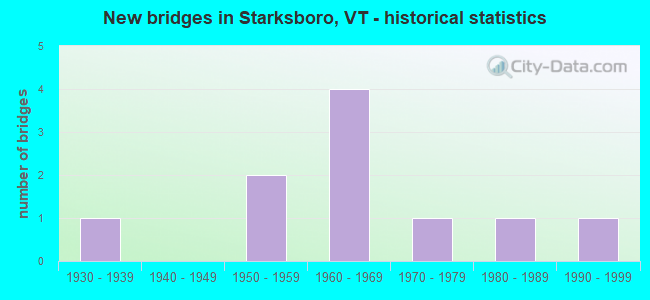
- New bridges - historical statistics
- 11930-1939
- 21950-1959
- 41960-1969
- 11970-1979
- 11980-1989
- 11990-1999
2002 - 2018 National Fire Incident Reporting System (NFIRS) incidents
- Fire incident types reported to NFIRS in Starksboro, VT
- 9179.1%Structure Fires
- 1513.0%Outside Fires
- 65.2%Other
- 32.6%Mobile Property/Vehicle Fires
 According to the data from the years 2002 - 2018 the average number of fire incidents per year is 7. The highest number of fires - 13 took place in 2002, and the least - 0 in 2011. The data has a decreasing trend.
 When looking into fire subcategories, the most incidents belonged to: Structure Fires (79.1%), and Outside Fires (13.0%).
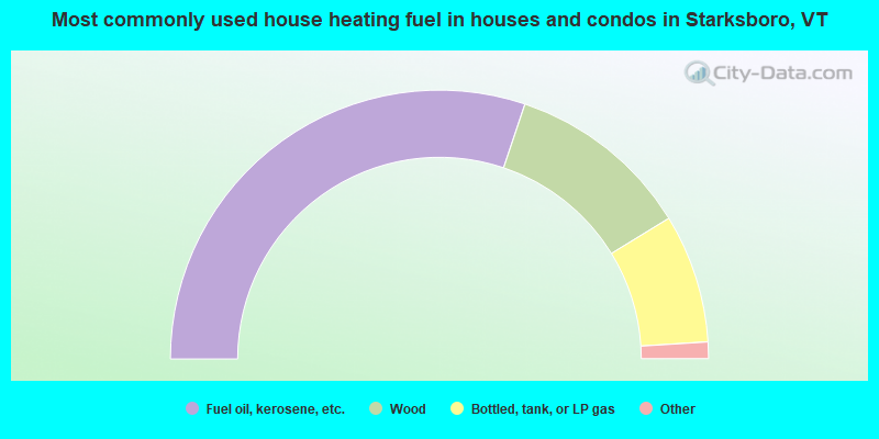
- 60.3%Fuel oil, kerosene, etc.
- 22.2%Wood
- 15.5%Bottled, tank, or LP gas
- 0.9%Utility gas
- 0.7%Coal or coke
- 0.4%Solar energy
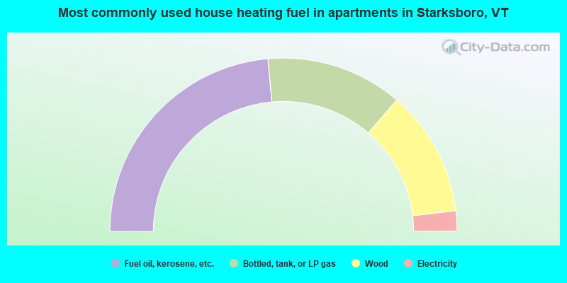
- 47.2%Fuel oil, kerosene, etc.
- 25.5%Bottled, tank, or LP gas
- 23.6%Wood
- 3.8%Electricity
Starksboro compared to Vermont state average:
- Unemployed percentage significantly below state average.
- Black race population percentage significantly below state average.
- Hispanic race population percentage significantly below state average.
- Median age below state average.
- Foreign-born population percentage significantly below state average.
- Renting percentage significantly below state average.
- Length of stay since moving in significantly above state average.
- Number of rooms per house significantly below state average.
- House age significantly below state average.
- Number of college students below state average.

|
|
Total of 14 patent applications in 2008-2024.