Royalton, Vermont
Submit your own pictures of this town and show them to the world
- OSM Map
- General Map
- Google Map
- MSN Map
Population change since 2000: +6.5%
 |
| Males: 1,389 | |
| Females: 1,384 |
| Median resident age: | 36.0 years |
| Vermont median age: | 45.8 years |
Zip codes: 05068.
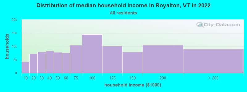
| Royalton: | $52,832 |
| VT: | $73,991 |
Estimated per capita income in 2022: $32,786 (it was $16,755 in 2000)
Royalton town income, earnings, and wages data
Estimated median house or condo value in 2022: $245,921 (it was $98,700 in 2000)
| Royalton: | $245,921 |
| VT: | $304,700 |
Mean prices in 2022: all housing units: $358,264; detached houses: $381,996; townhouses or other attached units: $340,107; in 2-unit structures: $283,645; in 3-to-4-unit structures: $498,076; in 5-or-more-unit structures: $190,965; mobile homes: $75,013
Detailed information about poverty and poor residents in Royalton, VT
Compare current foreclosures near Royalton, VT:
| Photo | Address | Area | Beds / Baths | Price | Details |
|---|---|---|---|---|---|

|
#1
Doe Hill Way
Woodstock, VT 05091
|
1,264 sq. feet
|
1 baths 1 beds |
$262,900
|
show details |

|
#2
Winter St W
West Lebanon, NH 03784
|
894 sq. feet
|
1 baths 2 beds |
show details | |

|
#3
Dartt Hill Rd, # Po122
Bethel, VT 05032
|
- sq. feet
|
- baths - beds |
show details | |

|
#4
Monarch Hill Rd
Tunbridge, VT 05077
|
- sq. feet
|
- baths - beds |
show details | |

|
#5
Dawn Dr
White River Junction, VT 05001
|
- sq. feet
|
- baths - beds |
show details | |

|
#6
Bugbee St Apt 31
White River Junction, VT 05001
|
- sq. feet
|
- baths - beds |
show details | |

|
#7
Gates St Apt 7
White River Junction, VT 05001
|
- sq. feet
|
- baths - beds |
show details | |

|
#8
S Main St Apt 2
White River Junction, VT 05001
|
- sq. feet
|
- baths - beds |
show details | |

|
#9
Downing Rd
Hanover, NH 03755
|
- sq. feet
|
- baths - beds |
show details | |

|
#10
Geno Rd
Bridgewater Corners, VT 05035
|
- sq. feet
|
- baths - beds |
show details |
| Photo | Address | Area | Beds / Baths | Price | Details |
|---|---|---|---|---|---|

|
#11
Horseshoe Ave
Wilder, VT 05088
|
- sq. feet
|
- baths - beds |
show details | |

|
Check over 1 million property listings on Foreclosure.com!
|
browse all offers | |||

- 2,61894.4%White alone
- 431.6%Two or more races
- 411.5%Hispanic
- 311.1%Asian alone
- 250.9%Black alone
- 110.4%American Indian alone
- 20.07%Native Hawaiian and Other
Pacific Islander alone - 20.07%Other race alone

Races in Royalton detailed stats: ancestries, foreign born residents, place of birth
Type |
2013 |
2014 |
2015 |
2016 |
2017 |
2018 |
2019 |
2020 |
2021 |
2022 |
|---|---|---|---|---|---|---|---|---|---|---|
| Murders (per 100,000) | 0 (0.0) | 0 (0.0) | 0 (0.0) | 0 (0.0) | 0 (0.0) | 0 (0.0) | 0 (0.0) | 0 (0.0) | 0 (0.0) | 0 (0.0) |
| Rapes (per 100,000) | 0 (0.0) | 0 (0.0) | 0 (0.0) | 0 (0.0) | 0 (0.0) | 0 (0.0) | 0 (0.0) | 1 (34.7) | 1 (34.6) | 1 (35.8) |
| Robberies (per 100,000) | 0 (0.0) | 0 (0.0) | 0 (0.0) | 0 (0.0) | 0 (0.0) | 0 (0.0) | 0 (0.0) | 0 (0.0) | 0 (0.0) | 0 (0.0) |
| Assaults (per 100,000) | 0 (0.0) | 0 (0.0) | 2 (72.4) | 5 (182.4) | 0 (0.0) | 0 (0.0) | 0 (0.0) | 0 (0.0) | 1 (34.6) | 0 (0.0) |
| Burglaries (per 100,000) | 1 (36.1) | 2 (72.3) | 0 (0.0) | 5 (182.4) | 4 (142.1) | 1 (35.3) | 0 (0.0) | 3 (104.1) | 4 (138.3) | 2 (71.6) |
| Thefts (per 100,000) | 1 (36.1) | 2 (72.3) | 12 (434.6) | 19 (693.2) | 10 (355.2) | 9 (317.5) | 10 (349.2) | 12 (416.5) | 14 (484.1) | 19 (680.0) |
| Auto thefts (per 100,000) | 0 (0.0) | 1 (36.2) | 1 (36.2) | 2 (73.0) | 1 (35.5) | 1 (35.3) | 1 (34.9) | 1 (34.7) | 0 (0.0) | 0 (0.0) |
| Arson (per 100,000) | 0 (0.0) | 0 (0.0) | 0 (0.0) | 0 (0.0) | 0 (0.0) | 0 (0.0) | 0 (0.0) | 0 (0.0) | 0 (0.0) | 0 (0.0) |
| City-Data.com crime index | 4.0 | 10.8 | 34.8 | 82.8 | 27.0 | 18.0 | 16.8 | 54.5 | 63.6 | 60.8 |
The City-Data.com crime index weighs serious crimes and violent crimes more heavily. Higher means more crime, U.S. average is 246.1. It adjusts for the number of visitors and daily workers commuting into cities.
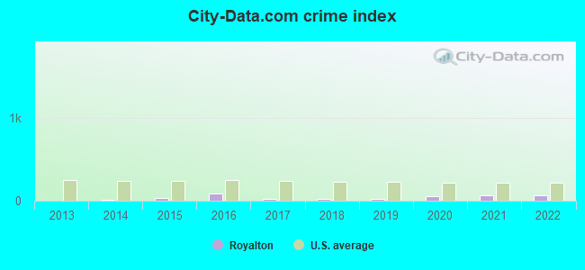
Crime rate in Royalton detailed stats: murders, rapes, robberies, assaults, burglaries, thefts, arson
Full-time law enforcement employees in 2021, including police officers: 3 (3 officers - 2 male; 1 female).
| Officers per 1,000 residents here: | 1.04 |
| Vermont average: | 1.69 |
 Recent articles from our blog. Our writers, many of them Ph.D. graduates or candidates, create easy-to-read articles on a wide variety of topics.

 | Question About old AMC / Dodge Dealership near Randolph - South Royalton?? (2 replies) |
| Driving Thru Vermont-Mountain Recommendation(s) (12 replies) |
| Vermont property taxes: beyond ridiculous! (422 replies) |
| Renting in VT/NH area for grad school (7 replies) |
| Skiing near South Royalton or south of that. Some background. (4 replies) |
| Vermont least religious again - why? (44 replies) |
Latest news from Royalton, VT collected exclusively by city-data.com from local newspapers, TV, and radio stations
Ancestries: English (19.9%), Irish (11.9%), French (10.1%), United States (8.0%), German (7.5%), French Canadian (6.6%).
Current Local Time: EST time zone
Elevation: 516 feet
Land area: 40.4 square miles.
Population density: 69 people per square mile (very low).
47 residents are foreign born
| This town: | 1.8% |
| Vermont: | 3.8% |
| Royalton town: | 1.4% ($1,431) |
| Vermont: | 2.0% ($2,196) |
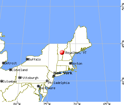
Nearest city with pop. 50,000+: Manchester, NH  (79.5 miles , pop. 107,006).
Nearest city with pop. 200,000+: Boston, MA (126.9 miles , pop. 589,141).
Nearest city with pop. 1,000,000+: Bronx, NY (216.3 miles , pop. 1,332,650).
Nearest cities:
), ), ), ), ), Latitude: 43.82 N, Longitude: 72.55 W
Area code commonly used in this area: 802

| Here: | 1.6% |
| Vermont: | 2.0% |
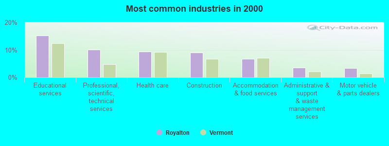
- Educational services (15.3%)
- Professional, scientific, technical services (10.1%)
- Health care (9.4%)
- Construction (9.1%)
- Accommodation & food services (6.7%)
- Administrative & support & waste management services (3.6%)
- Motor vehicle & parts dealers (3.3%)
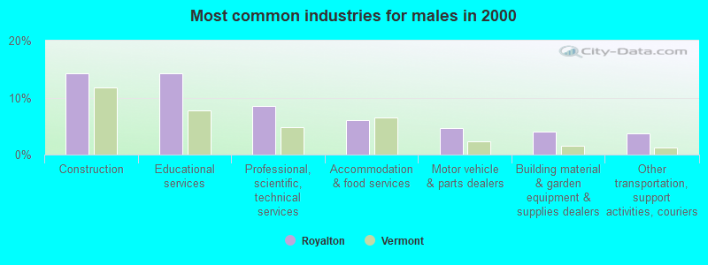
- Construction (14.3%)
- Educational services (14.3%)
- Professional, scientific, technical services (8.5%)
- Accommodation & food services (6.1%)
- Motor vehicle & parts dealers (4.6%)
- Building material & garden equipment & supplies dealers (4.0%)
- Other transportation, support activities, couriers (3.7%)
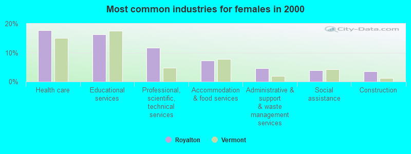
- Health care (17.6%)
- Educational services (16.2%)
- Professional, scientific, technical services (11.7%)
- Accommodation & food services (7.3%)
- Administrative & support & waste management services (4.5%)
- Social assistance (3.9%)
- Construction (3.6%)
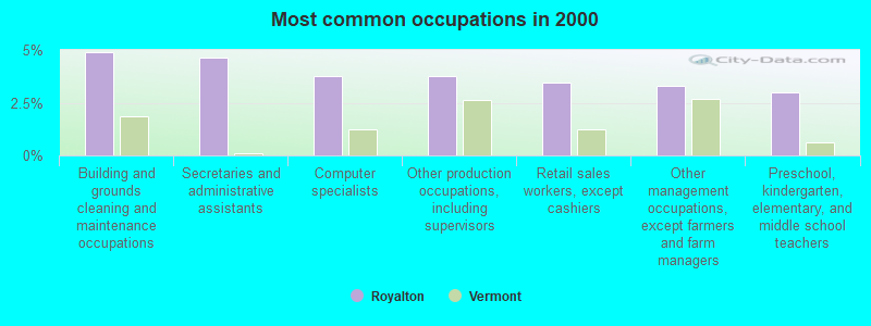
- Building and grounds cleaning and maintenance occupations (4.9%)
- Secretaries and administrative assistants (4.7%)
- Computer specialists (3.7%)
- Other production occupations, including supervisors (3.7%)
- Retail sales workers, except cashiers (3.4%)
- Other management occupations, except farmers and farm managers (3.3%)
- Preschool, kindergarten, elementary, and middle school teachers (3.0%)
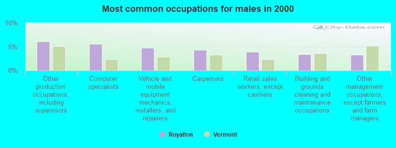
- Other production occupations, including supervisors (6.1%)
- Computer specialists (5.5%)
- Vehicle and mobile equipment mechanics, installers, and repairers (4.8%)
- Carpenters (4.3%)
- Retail sales workers, except cashiers (3.9%)
- Building and grounds cleaning and maintenance occupations (3.4%)
- Other management occupations, except farmers and farm managers (3.3%)
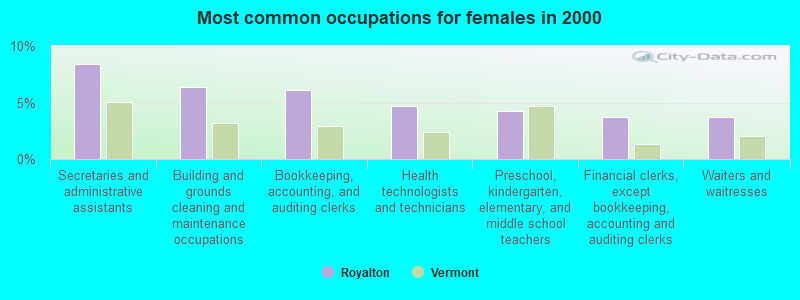
- Secretaries and administrative assistants (8.4%)
- Building and grounds cleaning and maintenance occupations (6.4%)
- Bookkeeping, accounting, and auditing clerks (6.1%)
- Health technologists and technicians (4.7%)
- Preschool, kindergarten, elementary, and middle school teachers (4.2%)
- Financial clerks, except bookkeeping, accounting and auditing clerks (3.7%)
- Waiters and waitresses (3.7%)
Average climate in Royalton, Vermont
Based on data reported by over 4,000 weather stations


(lower is better)
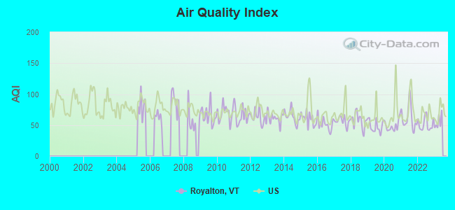
Air Quality Index (AQI) level in 2022 was 51.4. This is significantly better than average.
| City: | 51.4 |
| U.S.: | 72.6 |
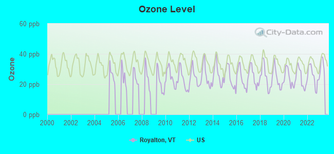
Ozone [ppb] level in 2022 was 25.3. This is better than average. Closest monitor was 16.2 miles away from the city center.
| City: | 25.3 |
| U.S.: | 33.3 |
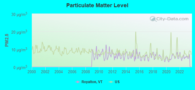
Particulate Matter (PM2.5) [µg/m3] level in 2022 was 5.54. This is significantly better than average. Closest monitor was 17.5 miles away from the city center.
| City: | 5.54 |
| U.S.: | 8.11 |
Tornado activity:
Royalton-area historical tornado activity is near Vermont state average. It is 75% smaller than the overall U.S. average.
On 8/11/1966, a category F2 (max. wind speeds 113-157 mph) tornado 25.7 miles away from the Royalton town center caused between $50,000 and $500,000 in damages.
On 8/20/1968, a category F3 (max. wind speeds 158-206 mph) tornado 51.1 miles away from the town center injured one person and caused between $5000 and $50,000 in damages.
Earthquake activity:
Royalton-area historical earthquake activity is significantly above Vermont state average. It is 70% smaller than the overall U.S. average.On 4/20/2002 at 10:50:47, a magnitude 5.3 (5.3 ML, Depth: 3.0 mi, Class: Moderate, Intensity: VI - VII) earthquake occurred 74.7 miles away from Royalton center
On 10/7/1983 at 10:18:46, a magnitude 5.3 (5.1 MB, 5.3 LG, 5.1 ML) earthquake occurred 90.0 miles away from the city center
On 4/20/2002 at 10:50:47, a magnitude 5.2 (5.2 MB, 4.2 MS, 5.2 MW, 5.0 MW) earthquake occurred 74.4 miles away from Royalton center
On 1/19/1982 at 00:14:42, a magnitude 4.7 (4.5 MB, 4.7 MD, 4.5 LG, Class: Light, Intensity: IV - V) earthquake occurred 52.2 miles away from Royalton center
On 10/16/2012 at 23:12:25, a magnitude 4.7 (4.7 ML, Depth: 10.0 mi) earthquake occurred 95.8 miles away from the city center
On 6/16/1995 at 12:13:11, a magnitude 3.8 (3.8 LG, Depth: 3.1 mi, Class: Light, Intensity: II - III) earthquake occurred 45.2 miles away from the city center
Magnitude types: regional Lg-wave magnitude (LG), body-wave magnitude (MB), duration magnitude (MD), local magnitude (ML), surface-wave magnitude (MS), moment magnitude (MW)
Natural disasters:
The number of natural disasters in Windsor County (20) is greater than the US average (15).Major Disasters (Presidential) Declared: 16
Emergencies Declared: 2
Causes of natural disasters: Floods: 14, Storms: 13, Tropical Storms: 2, Heavy Rain: 1, Hurricane: 1, Ice Storm: 1, Landslide: 1, Snowstorm: 1, Wind: 1, Winter Storm: 1 (Note: some incidents may be assigned to more than one category).
Hospitals and medical centers near Royalton:
- GIFFORD MEDICAL CENTER Critical Access Hospitals (about 10 miles away; RANDOLPH, VT)
- MENIG EXTENDED CARE (Nursing Home, about 10 miles away; RANDOLPH, VT)
- GIFFORD ELDERLY CARE INC (Nursing Home, about 10 miles away; RANDOLPH, VT)
- VNA AND HOSPICE OF VERMONT AND NH (Hospital, about 15 miles away; WHITE RIVER JUNCTION, VT)
- BROOKSIDE HEALTH AND REHABILITATION (Nursing Home, about 16 miles away; WHITE RIVER JUNCTION, VT)
- KENDAL AT HANOVER (Nursing Home, about 16 miles away; HANOVER, NH)
- HANOVER TERRACE HEALTHCARE (Nursing Home, about 16 miles away; HANOVER, NH)
Amtrak stations near Royalton:
- 10 miles: RANDOLPH (DEPOT SQ.) . Services: enclosed waiting area, public restrooms, public payphones, snack bar, ATM, free short-term parking, free long-term parking, public transit connection.
- 17 miles: WHITE RIVER JUNCTION (RAILROAD ROW) . Services: ticket office, fully wheelchair accessible, enclosed waiting area, public restrooms, public payphones, free short-term parking, paid long-term parking, call for car rental service, call for taxi service, public transit connection.
- 17 miles: KILLINGTON (RTE 4) - Seasonal Bus Station . Services: fully wheelchair accessible, enclosed waiting area, public payphones, snack bar, free short-term parking, call for car rental service, call for taxi service, public transit connection.
Colleges/universities with over 2000 students nearest to Royalton:
- Dartmouth College (about 16 miles; Hanover, NH; Full-time enrollment: 6,030)
- Norwich University (about 24 miles; Northfield, VT; FT enrollment: 4,221)
- Middlebury College (about 35 miles; Middlebury, VT; FT enrollment: 3,077)
- Castleton State College (about 35 miles; Castleton, VT; FT enrollment: 2,079)
- Plymouth State University (about 43 miles; Plymouth, NH; FT enrollment: 4,838)
- Champlain College (about 56 miles; Burlington, VT; FT enrollment: 2,623)
- Saint Michael's College (about 56 miles; Colchester, VT; FT enrollment: 2,336)
Points of interest:
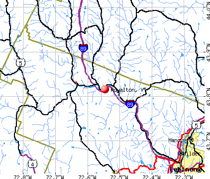
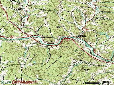
Notable locations in Royalton: Lone Oak Farm (A), Julian and Virginia Cornell Library (B), South Royal Fire Department (C). Display/hide their locations on the map
Cemeteries: Haven Cemetery (1), Hickey Cemetery (2), South Royalton Village Cemetery (3), Pleasant Hill Cemetery (4), North Royalton Cemetery (5), Branchview Cemetery (6), Dewey Cemetery (7). Display/hide their locations on the map
Reservoir: McIntosh Pond (A). Display/hide its location on the map
Streams, rivers, and creeks: Sewall Brook (A), Second Branch White River (B), Russell Brook (C), First Branch White River (D). Display/hide their locations on the map
Park in Royalton: Joseph Smith Monument (1). Display/hide its location on the map
Birthplace of: Frederick H. Billings - Railroad executive, Charles Durkee - Politician, Dudley Chase Denison - Politician.
Drinking water stations with addresses in Royalton and their reported violations in the past:
EATONS SUGARHOUSE (Address: 5894 VT RTE 14 , Population served: 70, Groundwater):Past monitoring violations:
- 5 routine major monitoring violations
| This town: | 2.1 people |
| Vermont: | 2.3 people |
| This town: | 51.7% |
| Whole state: | 62.5% |
| This town: | 9.5% |
| Whole state: | 9.2% |
Likely homosexual households (counted as self-reported same-sex unmarried-partner households)
- Lesbian couples: 0.6% of all households
- Gay men: 0.3% of all households
| This town: | 15.0% |
| Whole state: | 9.4% |
| This town: | 7.5% |
| Whole state: | 3.6% |
Banks with branches in Royalton (2011 data):
- The Randolph National Bank: Royalton Route 107 Branch at Route 107 And Interstate 89, branch established on 1997/03/03. Info updated 2010/06/02: Bank assets: $171.5 mil, Deposits: $151.6 mil, headquarters in Randolph, VT, positive income, Commercial Lending Specialization, 9 total offices, Holding Company: Central Financial Corporation
For population 15 years and over in Royalton:
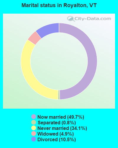
- Never married: 34.1%
- Now married: 49.7%
- Separated: 0.8%
- Widowed: 4.9%
- Divorced: 10.5%
For population 25 years and over in Royalton:
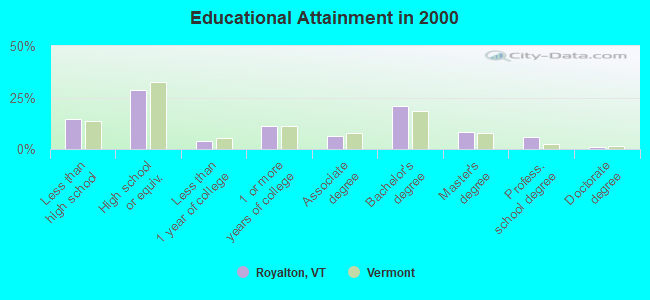
- High school or higher: 85.4%
- Bachelor's degree or higher: 35.5%
- Graduate or professional degree: 14.7%
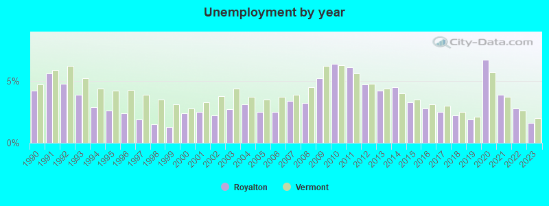
- Unemployed: 2.3%
- Mean travel time to work (commute): 25.9 minutes
| Here: | 12.5 |
| Vermont average: | 11.7 |
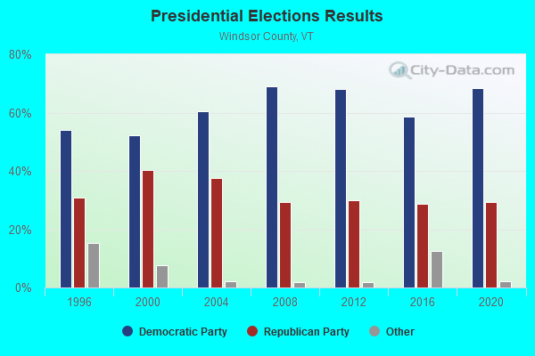
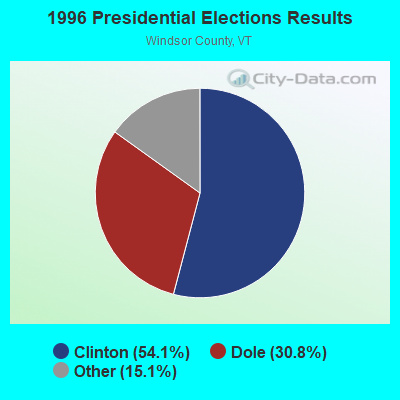
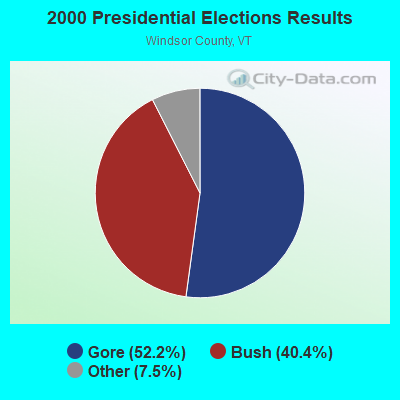
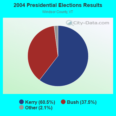
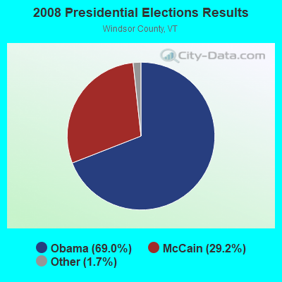
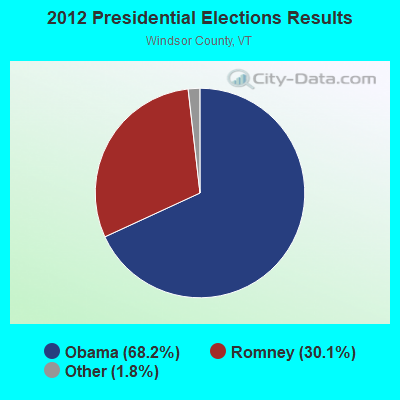
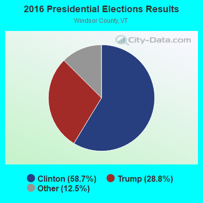
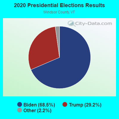
Graphs represent county-level data. Detailed 2008 Election Results
Religion statistics for Royalton, VT (based on Windsor County data)
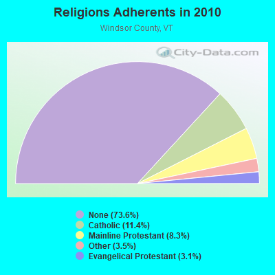
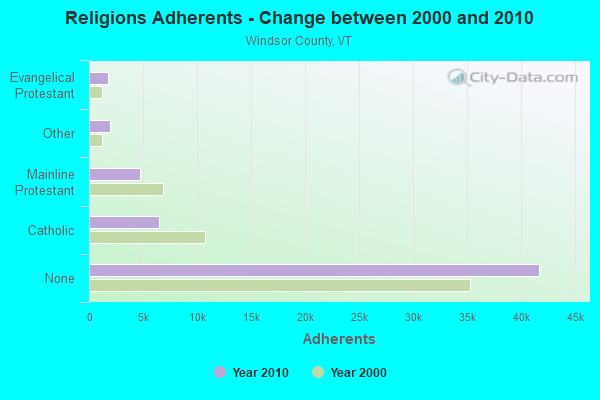
| Religion | Adherents | Congregations |
|---|---|---|
| Catholic | 6,485 | 10 |
| Mainline Protestant | 4,700 | 45 |
| Other | 1,964 | 17 |
| Evangelical Protestant | 1,750 | 21 |
| Orthodox | 55 | 1 |
| None | 41,716 | - |
Food Environment Statistics:
| This county: | 4.93 / 10,000 pop. |
| Vermont: | 3.84 / 10,000 pop. |
| This county: | 1.23 / 10,000 pop. |
| State: | 1.95 / 10,000 pop. |
| Windsor County: | 7.93 / 10,000 pop. |
| Vermont: | 6.40 / 10,000 pop. |
| Here: | 14.97 / 10,000 pop. |
| Vermont: | 11.52 / 10,000 pop. |
| Windsor County: | 7.1% |
| State: | 6.8% |
| Windsor County: | 22.8% |
| Vermont: | 22.3% |
| This county: | 9.7% |
| Vermont: | 13.3% |
Strongest AM radio stations in Royalton:
- WWWT (1320 AM; 1 kW; RANDOLPH, VT; Owner: CAPSTAR TX LIMITED PARTNERSHIP)
- WNTK (1020 AM; 10 kW; NEWPORT, NH; Owner: KOOR COMMUNICATIONS, INC.)
- WGY (810 AM; 50 kW; SCHENECTADY, NY; Owner: CLEAR CHANNEL BROADCASTING LICENSES, INC.)
- WNNZ (640 AM; 50 kW; WESTFIELD, MA; Owner: CLEAR CHANNEL BROADCASTING LICENSES, INC.)
- WDEV (550 AM; 5 kW; WATERBURY, VT; Owner: RADIO VERMONT, INC.)
- WCHP (760 AM; 35 kW; CHAMPLAIN, NY; Owner: CHAMPLAIN RADIO, INC.)
- WRKO (680 AM; 50 kW; BOSTON, MA; Owner: ENTERCOM BOSTON LICENSE, LLC)
- WSYB (1380 AM; 5 kW; RUTLAND, VT; Owner: CAPSTAR TX LIMITED PARTNERSHIP)
- WCRN (830 AM; 50 kW; WORCESTER, MA; Owner: CARTER BROADCASTING CORPORATION)
- WTWN (1100 AM; daytime; 5 kW; WELLS RIVER, VT; Owner: PUFFER BROADCASTING, INC.)
- WNHV (910 AM; 1 kW; WHITE RIVER JUNCTION, VT)
- WEEI (850 AM; 50 kW; BOSTON, MA; Owner: ENTERCOM BOSTON LICENSE, LLC)
- WPTR (1540 AM; 50 kW; ALBANY, NY; Owner: KIMTRON, INC.)
Strongest FM radio stations in Royalton:
- WEBK (105.3 FM; KILLINGTON, VT; Owner: 6 JOHNSON ROAD LICENSES, INC.)
- WJJR (98.1 FM; RUTLAND, VT; Owner: 6 JOHNSON ROAD LICENSES, INC.)
- WZRT (97.1 FM; RUTLAND, VT; Owner: CAPSTAR TX LIMITED PARTNERSHIP)
- WGLV (91.7 FM; WOODSTOCK, VT; Owner: CHRISTIAN MINISTRIES INC)
- WHDQ-FM1 (106.1 FM; RUTLAND, VT; Owner: GREAT NORTHERN RADIO, L.L.C.)
- WRJT (103.1 FM; ROYALTON, VT; Owner: LISBON COMMUNICATIONS, INC.)
- WVPR (89.5 FM; WINDSOR, VT; Owner: VERMONT PUBLIC RADIO)
- WDEV-FM (96.1 FM; WARREN, VT; Owner: RADIO VERMONT, INC.)
- WJEN (94.5 FM; RUTLAND, VT; Owner: 6 JOHNSON ROAD LICENSES, INC.)
- WHDQ (106.1 FM; CLAREMONT, NH; Owner: GREAT NORTHERN RADIO, L.L.C.)
- WEVH (91.3 FM; HANOVER, NH; Owner: NEW HAMPSHIRE PUBLIC RADIO INC)
- WCVR-FM (102.1 FM; RANDOLPH, VT; Owner: CAPSTAR TX LIMITED PARTNERSHIP)
- WMXR (93.9 FM; WOODSTOCK, VT; Owner: CLEAR CHANNEL BROADCASTING LICENSES, INC.)
- WCVT (101.7 FM; STOWE, VT; Owner: RADIO VERMONT CLASSICS, L.L.C.)
- WXXK (100.5 FM; LEBANON, NH; Owner: CAPSTAR TX LIMITED PARTNERSHIP)
- WEXP (101.5 FM; BRANDON, VT; Owner: VOX VERMONT, L.L.C.)
- WVPS (107.9 FM; BURLINGTON, VT; Owner: VERMONT PUBLIC RADIO)
- WEZF (92.9 FM; BURLINGTON, VT; Owner: CAPSTAR TX LIMITED PARTNERSHIP)
- WLKC (103.3 FM; WATERBURY, VT; Owner: RADIO BROADCASTING SERVICES, INC.)
- WWOD (104.3 FM; HARTFORD, VT; Owner: FAMILY BROADCASTING, INC.)
TV broadcast stations around Royalton:
- W15BK (Channel 15; HANOVER, NH; Owner: UNIVERSITY OF NEW HAMPSHIRE)
- WVTA (Channel 41; WINDSOR, VT; Owner: VERMONT ETV, INC.)
- National Bridge Inventory (NBI) Statistics
- 26Number of bridges
- 387ft / 118mTotal length
- $31,411,000Total costs
- 141,760Total average daily traffic
- 15,706Total average daily truck traffic
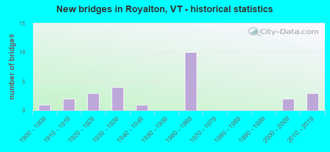
- New bridges - historical statistics
- 11900-1909
- 21910-1919
- 31920-1929
- 41930-1939
- 11940-1949
- 101960-1969
- 22000-2009
- 32010-2019
FCC Registered Broadcast Land Mobile Towers:
6- Rt 107 District Highway Garage (Lat: 43.822833 Lon: -72.604000), Call Sign: KEW92,
Assigned Frequencies: 151.040 MHz, Grant Date: 08/25/2022, Expiration Date: 09/14/2032, Registrant: State Of Vermont, 45 State Drive, Watterbury, VT 05671, Phone: (802) 229-0882, Fax: (802) 241-5615, Email:
- Summit Of Russ Hill (Lat: 43.856444 Lon: -72.553722), Call Sign: KFG729,
Assigned Frequencies: 159.195 MHz, 159.195 MHz, Grant Date: 03/03/2015, Expiration Date: 04/09/2025, Registrant: State Of Vermont, 45 State Drive, Watterbury, VT 05671, Phone: (802) 229-0882, Fax: (802) 241-5553, Email:
- 1.5 Mi From Rt 107 & 12 (Lat: 43.807278 Lon: -72.500083), Call Sign: KNBF260,
Assigned Frequencies: 45.0800 MHz, Grant Date: 02/02/2001, Expiration Date: 01/17/2011, Cancellation Date: 03/19/2011, Registrant: R&r Communications, Inc., Swanzey, NH 03446, Phone: (603) 352-1825, Email:
- RUSS HILL, Summit Of Russ Hill (Lat: 43.855056 Lon: -72.554833), Type: Tower, Structure height: 36.4 m, Call Sign: WQHD216,
Assigned Frequencies: 453.212 MHz, 453.212 MHz, 453.462 MHz, 453.462 MHz, 453.712 MHz, 453.712 MHz, 453.862 MHz, 453.862 MHz, Grant Date: 04/28/2017, Expiration Date: 07/02/2027, Certifier: Terry Lavalley, Registrant: State Of Vermont, 45 State Drive, Watterbury, VT 05671, Phone: (802) 229-0882, Fax: (802) 241-5557, Email:
- RUSS HILL, Summit Of Russ Hill (Lat: 43.855056 Lon: -72.554833), Type: Tower, Structure height: 36.4 m, Call Sign: WQHD220,
Assigned Frequencies: 154.452 MHz, 154.452 MHz, 155.752 MHz, 155.752 MHz, 158.737 MHz, 158.737 MHz, 159.472 MHz, 159.472 MHz, 151.137 MHz, 151.137 MHz, Grant Date: 04/28/2017, Expiration Date: 07/02/2027, Certifier: Terry Lavalley, Registrant: State Of Vermont, 45 State Drive, Watterbury, VT 05671, Phone: (802) 229-0882, Fax: (802) 241-5557, Email:
- RUSS HILL, 432 Falcon Ridge Ln (Lat: 43.855194 Lon: -72.554861), Type: Ltower, Structure height: 42.7 m, Call Sign: WRUE407,
Assigned Frequencies: 460.387 MHz, Grant Date: 08/17/2022, Expiration Date: 08/17/2032, Certifier: Loretta Stalnaker, Registrant: Burlington Communications, 4735 Williston Rd. Ste 30, Williston, VT 05495, Phone: (802) 862-7092, Email:
FCC Registered Microwave Towers:
4- SOUTH ROYALTON, 27024 Church Hill Road (Lat: 43.835806 Lon: -72.546833), Type: Mast, Structure height: 36.6 m, Overall height: 37.5 m, Call Sign: WMQ854,
Assigned Frequencies: 6585.00 MHz, Grant Date: 03/08/2011, Expiration Date: 02/01/2021, Cancellation Date: 02/16/2017, Certifier: Michael P Goggin, Registrant: At&t Mobility LLC, 1120 20th Street, Nw - Suite 1000, Washington, DC 20036, Phone: (202) 457-2055, Fax: (202) 457-3073, Email:
- 4LN0727C, 5 Gee Hill Rd (Lat: 43.835833 Lon: -72.546778), Type: Ltower, Structure height: 36.6 m, Call Sign: WQWW736,
Assigned Frequencies: 11385.0 MHz, 11385.0 MHz, 11385.0 MHz, 11385.0 MHz, 11385.0 MHz, 11385.0 MHz, 11385.0 MHz, 11385.0 MHz, Grant Date: 12/10/2015, Expiration Date: 12/10/2025, Cancellation Date: 05/05/2022, Certifier: David Werblow, Registrant: T-Mobile Usa, Inc., 12920 Se 38th Street, Bellevue, WA 98006, Phone: (425) 383-8401, Fax: (425) 383-4040, Email:
- BETHEL SUB, State Police Substation Us Route 107 (Lat: 43.822889 Lon: -72.604389), Type: Mast, Structure height: 10.7 m, Overall height: 15.2 m, Call Sign: WIS88,
Assigned Frequencies: 6830.00 MHz, Grant Date: 01/04/2018, Expiration Date: 03/04/2028, Registrant: State Of Vermont, 45 State Drive, Watterbury, VT 05671, Phone: (802) 229-0882, Fax: (802) 241-5557, Email:
- RUSS HILL, Summit Of Russ Hill (Lat: 43.855056 Lon: -72.554833), Type: Tower, Structure height: 4.3 m, Overall height: 6.4 m, Call Sign: WIS89,
Assigned Frequencies: 6600.62 MHz, 6670.00 MHz, 6600.00 MHz, Grant Date: 01/04/2018, Expiration Date: 03/04/2028, Registrant: State Of Vermont, 45 State Drive, Watterbury, VT 05671, Phone: (802) 229-0882, Fax: (802) 251-5557, Email:
FCC Registered Amateur Radio Licenses:
2- Call Sign: KC1SGA, Licensee ID: L02622517, Grant Date: 12/16/2022, Expiration Date: 12/16/2032, Certifier: Seth Hisman, Registrant: Seth Hisman, 1632 Moore Rd, S Royalton, VT 05068-9582
- Call Sign: KC1SGO, Licensee ID: L02622518, Grant Date: 12/20/2022, Expiration Date: 12/20/2032, Certifier: Melissa R Sharkis, Registrant: Melissa R Sharkis, S Royalton, VT 05068-0510
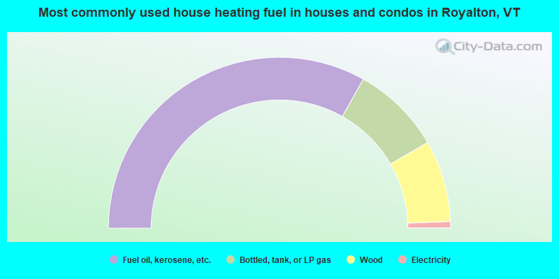
- 66.4%Fuel oil, kerosene, etc.
- 17.0%Bottled, tank, or LP gas
- 15.5%Wood
- 1.2%Electricity
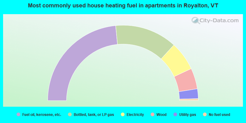
- 46.9%Fuel oil, kerosene, etc.
- 26.7%Bottled, tank, or LP gas
- 12.5%Electricity
- 8.9%Wood
- 4.2%Utility gas
- 0.8%No fuel used
Royalton compared to Vermont state average:
- Unemployed percentage significantly below state average.
- Median age significantly below state average.
- Foreign-born population percentage significantly below state average.
- Length of stay since moving in significantly above state average.
- Number of rooms per house significantly below state average.
- House age significantly below state average.

|
Total of 3 patent applications in 2008-2024.