Mason, New Hampshire
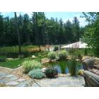
Submit your own pictures of this town and show them to the world
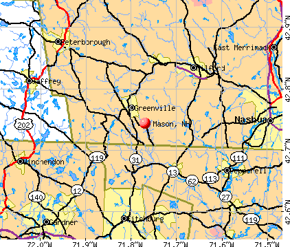
- OSM Map
- General Map
- Google Map
- MSN Map
Population change since 2000: +20.5%
| Males: 703 | |
| Females: 679 |
| Median resident age: | 44.7 years |
| New Hampshire median age: | 43.9 years |
Zip codes: 03048.
| Mason: | $109,719 |
| NH: | $89,992 |
Estimated per capita income in 2022: $56,843 (it was $28,503 in 2000)
Mason town income, earnings, and wages data
Estimated median house or condo value in 2022: $427,349 (it was $142,100 in 2000)
| Mason: | $427,349 |
| NH: | $384,700 |
Mean prices in 2022: all housing units: $411,252; detached houses: $441,251; townhouses or other attached units: $283,002; in 2-unit structures: $347,377; in 3-to-4-unit structures: $666,663; in 5-or-more-unit structures: $275,798; mobile homes: $132,093
Detailed information about poverty and poor residents in Mason, NH
Compare current foreclosures near Mason, NH:
| Photo | Address | Area | Beds / Baths | Price | Details |
|---|---|---|---|---|---|

|
#1
Sylvan Ave
Leominster, MA 01453
|
720 sq. feet
|
1 baths 2 beds |
$375,000
|
show details |

|
#2
Great Rd
Shirley, MA 01464
|
1,672 sq. feet
|
1 baths 2 beds |
$464,900
|
show details |

|
#3
Parker St
Gardner, MA 01440
|
1,980 sq. feet
|
2 baths 4 beds |
$469,900
|
show details |

|
#4
Iriquois Dr
Ashburnham, MA 01430
|
2,016 sq. feet
|
2 baths 3 beds |
$369,000
|
show details |

|
#5
Pearl Hill Rd
Fitchburg, MA 01420
|
2,152 sq. feet
|
2 baths 3 beds |
$529,900
|
show details |

|
#6
Amherst St
Amherst, NH 03031
|
- sq. feet
|
4 baths 3 beds |
show details | |

|
#7
Chapman Park
Gardner, MA 01440
|
1,296 sq. feet
|
3 baths 3 beds |
show details | |

|
#8
Park Ave
Leominster, MA 01453
|
1,008 sq. feet
|
1 baths 3 beds |
show details | |

|
#9
Green St
Gardner, MA 01440
|
2,231 sq. feet
|
2 baths 3 beds |
show details | |

|
#10
Hemlock Dr
Lunenburg, MA 01462
|
696 sq. feet
|
1 baths 2 beds |
show details |
| Photo | Address | Area | Beds / Baths | Price | Details |
|---|---|---|---|---|---|

|
#11
E Main St
Ayer, MA 01432
|
1,404 sq. feet
|
2 baths 3 beds |
show details | |

|
#12
Leominster St
Westminster, MA 01473
|
3,120 sq. feet
|
3 baths 4 beds |
show details | |

|
#13
Taggart Cir
Rindge, NH 03461
|
1,870 sq. feet
|
1 baths 3 beds |
show details | |

|
#14
Martel St
Fitchburg, MA 01420
|
1,064 sq. feet
|
1 baths 3 beds |
show details | |

|
#15
Cedar Ter
Winchendon, MA 01475
|
1,475 sq. feet
|
2 baths 3 beds |
show details | |

|
#16
Grove Ave
Leominster, MA 01453
|
3,097 sq. feet
|
1 baths 4 beds |
show details | |

|
#17
Goodrich St
Lunenburg, MA 01462
|
2,976 sq. feet
|
4 baths 6 beds |
show details | |

|
#18
Chestnut St
Leominster, MA 01453
|
2,430 sq. feet
|
2 baths 5 beds |
show details | |

|
#19
Colony Rd
Westminster, MA 01473
|
2,579 sq. feet
|
3 baths 4 beds |
show details | |

|
#20
Pine Ave
Ashburnham, MA 01430
|
714 sq. feet
|
1 baths 2 beds |
show details |
| Photo | Address | Area | Beds / Baths | Price | Details |
|---|---|---|---|---|---|

|
#21
Cedar St
Winchendon, MA 01475
|
2,300 sq. feet
|
2 baths 4 beds |
show details | |

|
#22
Leo Dr
Gardner, MA 01440
|
1,206 sq. feet
|
1 baths 3 beds |
show details | |

|
#23
Valley Rd
Lunenburg, MA 01462
|
2,620 sq. feet
|
3 baths 4 beds |
show details | |

|
#24
Lincoln St
Leominster, MA 01453
|
1,600 sq. feet
|
2 baths 3 beds |
show details | |

|
#25
Norma Dr
Nashua, NH 03062
|
1,361 sq. feet
|
3 baths 3 beds |
show details | |

|
#26
West Rd
Ashby, MA 01431
|
7,000 sq. feet
|
3 baths 10 beds |
show details | |

|
#27
Fitchburg State Rd
Ashby, MA 01431
|
1,277 sq. feet
|
2 baths 4 beds |
show details | |

|
#28
West St
Gardner, MA 01440
|
1,130 sq. feet
|
3 baths 3 beds |
show details | |

|
#29
Fordway Rd
Townsend, MA 01469
|
2,596 sq. feet
|
3 baths 4 beds |
show details | |

|
#30
Newtonville Ave
Fitchburg, MA 01420
|
952 sq. feet
|
1 baths 3 beds |
show details |
| Photo | Address | Area | Beds / Baths | Price | Details |
|---|---|---|---|---|---|

|
#31
Weston Hill Rd
Mont Vernon, NH 03057
|
2,116 sq. feet
|
1 baths 2 beds |
show details | |

|
#32
Bernard Dr
Fitchburg, MA 01420
|
1,461 sq. feet
|
1 baths 4 beds |
show details | |

|
#33
Greenwich Ave
Leominster, MA 01453
|
966 sq. feet
|
1 baths 2 beds |
show details | |

|
#34
Maple St
Pepperell, MA 01463
|
2,852 sq. feet
|
3 baths 4 beds |
show details | |

|
#35
Mont Vernon Rd
New Boston, NH 03070
|
3,854 sq. feet
|
2 baths 3 beds |
show details | |

|
#36
W End Ave
Gardner, MA 01440
|
1,384 sq. feet
|
2 baths 3 beds |
show details | |

|
#37
Main St
West Townsend, MA 01474
|
840 sq. feet
|
1 baths 2 beds |
show details | |

|
#38
Hall St
Leominster, MA 01453
|
3,724 sq. feet
|
3 baths 5 beds |
show details | |

|
#39
Stone St
Gardner, MA 01440
|
1,908 sq. feet
|
2 baths 3 beds |
show details | |

|
#40
View St
Leominster, MA 01453
|
2,401 sq. feet
|
2 baths 4 beds |
show details |
| Photo | Address | Area | Beds / Baths | Price | Details |
|---|---|---|---|---|---|

|
#41
Sunrise Ave
Leominster, MA 01453
|
3,321 sq. feet
|
2 baths 4 beds |
show details | |

|
#42
Grove Ave
Leominster, MA 01453
|
3,097 sq. feet
|
1 baths 4 beds |
show details | |

|
#43
Pearly Ln
Gardner, MA 01440
|
1,728 sq. feet
|
2 baths 4 beds |
show details | |

|
#44
Hartford St
Fitchburg, MA 01420
|
2,484 sq. feet
|
2 baths 6 beds |
show details | |

|
#45
Lancaster Rd
Shirley, MA 01464
|
1,704 sq. feet
|
1 baths 4 beds |
show details | |

|
#46
Prospect St
Leominster, MA 01453
|
4,884 sq. feet
|
2 baths 4 beds |
show details | |

|
#47
Ayer Rd
Shirley, MA 01464
|
1,134 sq. feet
|
1 baths 2 beds |
show details | |

|
#48
Walnut Ct
Leominster, MA 01453
|
2,880 sq. feet
|
2 baths 4 beds |
show details | |

|
#49
High St
Leominster, MA 01453
|
1,555 sq. feet
|
3 baths 4 beds |
show details | |

|
Check over 1 million property listings on Foreclosure.com!
|
browse all offers | |||

- 1,34797.5%White alone
- 151.1%Hispanic
- 90.7%Asian alone
- 80.6%Two or more races
- 20.1%Other race alone
- 10.07%Black alone

Races in Mason detailed stats: ancestries, foreign born residents, place of birth
According to our research of New Hampshire and other state lists, there were 5 registered sex offenders living in Mason, New Hampshire as of June 01, 2024.
The ratio of all residents to sex offenders in Mason is 276 to 1.
Type |
2017 |
2018 |
2019 |
2020 |
2021 |
2022 |
|---|---|---|---|---|---|---|
| Murders (per 100,000) | 0 (0.0) | 0 (0.0) | 0 (0.0) | 0 (0.0) | 0 (0.0) | 0 (0.0) |
| Rapes (per 100,000) | 0 (0.0) | 0 (0.0) | 0 (0.0) | 0 (0.0) | 0 (0.0) | 0 (0.0) |
| Robberies (per 100,000) | 0 (0.0) | 0 (0.0) | 0 (0.0) | 0 (0.0) | 0 (0.0) | 0 (0.0) |
| Assaults (per 100,000) | 0 (0.0) | 0 (0.0) | 1 (69.4) | 0 (0.0) | 3 (208.6) | 1 (69.0) |
| Burglaries (per 100,000) | 6 (423.4) | 2 (140.6) | 1 (69.4) | 0 (0.0) | 0 (0.0) | 3 (206.9) |
| Thefts (per 100,000) | 1 (70.6) | 2 (140.6) | 4 (277.6) | 4 (278.2) | 4 (278.2) | 2 (137.9) |
| Auto thefts (per 100,000) | 0 (0.0) | 0 (0.0) | 0 (0.0) | 0 (0.0) | 2 (139.1) | 0 (0.0) |
| Arson (per 100,000) | 0 (0.0) | 0 (0.0) | 0 (0.0) | 0 (0.0) | 0 (0.0) | 0 (0.0) |
| City-Data.com crime index | 32.5 | 15.5 | 29.8 | 11.1 | 64.0 | 33.8 |
The City-Data.com crime index weighs serious crimes and violent crimes more heavily. Higher means more crime, U.S. average is 246.1. It adjusts for the number of visitors and daily workers commuting into cities.

Crime rate in Mason detailed stats: murders, rapes, robberies, assaults, burglaries, thefts, arson
Full-time law enforcement employees in 2021, including police officers: 2 (2 officers - 2 male; 0 female).
| Officers per 1,000 residents here: | 1.39 |
| New Hampshire average: | 2.14 |
 Recent articles from our blog. Our writers, many of them Ph.D. graduates or candidates, create easy-to-read articles on a wide variety of topics.

 | New Hampshire Farm Stands or Farm Stores (9 replies) |
| Communities of Color: Possibly moving to NH for a job (42 replies) |
| What do Bode, Uncle Sam and Little Red Riding Hood have in common? (0 replies) |
| Making it work in Mason area (4 replies) |
| Looking at Southern NH...Where would you recommend searching? (15 replies) |
| Has Anyone Moved to New Hampshire and Regretted It? (337 replies) |
Latest news from Mason, NH collected exclusively by city-data.com from local newspapers, TV, and radio stations
Ancestries: Irish (23.2%), English (18.6%), French (12.3%), French Canadian (9.4%), German (9.4%), Italian (8.8%).
Current Local Time: EST time zone
Incorporated in 1768
Elevation: 760 feet
Land area: 23.9 square miles.
Population density: 58 people per square mile (very low).
43 residents are foreign born (1.7% Europe, 1.3% North America, 0.7% Asia).
| This town: | 3.7% |
| New Hampshire: | 4.4% |
| Mason town: | 1.9% ($2,746) |
| New Hampshire: | 2.3% ($2,946) |
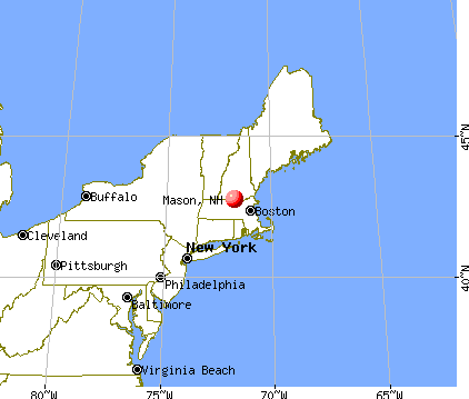
Nearest city with pop. 50,000+: Nashua, NH  (14.1 miles , pop. 86,605).
Nearest city with pop. 200,000+: Boston, MA (44.8 miles , pop. 589,141).
Nearest city with pop. 1,000,000+: Bronx, NY (170.5 miles , pop. 1,332,650).
Nearest cities:
), ), ), Latitude: 42.74 N, Longitude: 71.76 W
Area code commonly used in this area: 603


Single-family new house construction building permits:
- 2022: 4 buildings, average cost: $262,500
- 2021: 3 buildings, average cost: $262,500
- 2020: 2 buildings, average cost: $262,500
- 2019: 2 buildings, average cost: $261,800
- 2018: 2 buildings, average cost: $261,800
- 2017: 2 buildings, average cost: $261,800
- 2016: 2 buildings, average cost: $261,800
- 2015: 3 buildings, average cost: $266,700
- 2014: 4 buildings, average cost: $130,000
- 2013: 1 building, cost: $146,600
- 2012: 1 building, cost: $146,600
- 2011: 5 buildings, average cost: $66,200
- 2010: 4 buildings, average cost: $103,200
- 2009: 3 buildings, average cost: $71,400
- 2008: 6 buildings, average cost: $110,000
- 2007: 10 buildings, average cost: $105,700
- 2006: 13 buildings, average cost: $129,600
- 2005: 18 buildings, average cost: $106,900
- 2004: 18 buildings, average cost: $106,900
- 2003: 18 buildings, average cost: $110,600
- 2002: 15 buildings, average cost: $88,700
- 2001: 9 buildings, average cost: $65,400
- 2000: 11 buildings, average cost: $65,500
- 1999: 12 buildings, average cost: $65,400
- 1998: 9 buildings, average cost: $65,700
- 1997: 11 buildings, average cost: $64,300


| Here: | 2.7% |
| New Hampshire: | 2.5% |


- Professional, scientific, technical services (10.2%)
- Computer & electronic products (10.1%)
- Construction (8.4%)
- Educational services (7.3%)
- Health care (7.0%)
- Accommodation & food services (6.0%)
- Food & beverage stores (3.7%)

- Construction (14.0%)
- Computer & electronic products (13.2%)
- Professional, scientific, technical services (12.3%)
- Accommodation & food services (4.7%)
- Metal & metal products (4.7%)
- Educational services (3.6%)
- Agriculture, forestry, fishing & hunting (3.0%)

- Health care (14.2%)
- Educational services (12.1%)
- Accommodation & food services (7.8%)
- Professional, scientific, technical services (7.5%)
- Computer & electronic products (6.0%)
- Food & beverage stores (5.3%)
- Arts, entertainment, recreation (4.3%)

- Other sales and related occupations, including supervisors (7.0%)
- Engineers (5.7%)
- Material recording, scheduling, dispatching, and distributing workers (4.3%)
- Metal workers and plastic workers (4.3%)
- Computer specialists (4.2%)
- Other production occupations, including supervisors (3.9%)
- Other management occupations, except farmers and farm managers (3.9%)

- Engineers (9.6%)
- Metal workers and plastic workers (7.1%)
- Other sales and related occupations, including supervisors (6.6%)
- Computer specialists (5.2%)
- Operations specialties managers, except financial managers (4.7%)
- Other production occupations, including supervisors (4.7%)
- Other management occupations, except farmers and farm managers (3.8%)

- Other sales and related occupations, including supervisors (7.5%)
- Material recording, scheduling, dispatching, and distributing workers (6.4%)
- Other office and administrative support workers, including supervisors (5.3%)
- Preschool, kindergarten, elementary, and middle school teachers (5.0%)
- Information and record clerks, except customer service representatives (5.0%)
- Secretaries and administrative assistants (4.6%)
- Other management occupations, except farmers and farm managers (3.9%)
Average climate in Mason, New Hampshire
Based on data reported by over 4,000 weather stations


(lower is better)

Air Quality Index (AQI) level in 2022 was 62.9. This is about average.
| City: | 62.9 |
| U.S.: | 72.6 |

Carbon Monoxide (CO) [ppm] level in 2022 was 0.138. This is significantly better than average. Closest monitor was 10.3 miles away from the city center.
| City: | 0.138 |
| U.S.: | 0.251 |

Nitrogen Dioxide (NO2) [ppb] level in 2022 was 6.91. This is worse than average. Closest monitor was 10.3 miles away from the city center.
| City: | 6.91 |
| U.S.: | 5.11 |

Sulfur Dioxide (SO2) [ppb] level in 2022 was 0.376. This is significantly better than average. Closest monitor was 10.3 miles away from the city center.
| City: | 0.376 |
| U.S.: | 1.515 |

Ozone [ppb] level in 2022 was 32.3. This is about average. Closest monitor was 10.3 miles away from the city center.
| City: | 32.3 |
| U.S.: | 33.3 |

Particulate Matter (PM10) [µg/m3] level in 2022 was 10.6. This is significantly better than average. Closest monitor was 8.3 miles away from the city center.
| City: | 10.6 |
| U.S.: | 19.2 |

Particulate Matter (PM2.5) [µg/m3] level in 2022 was 4.70. This is significantly better than average. Closest monitor was 10.3 miles away from the city center.
| City: | 4.70 |
| U.S.: | 8.11 |
Tornado activity:
Mason-area historical tornado activity is above New Hampshire state average. It is 24% smaller than the overall U.S. average.
On 6/9/1953, a category F4 (max. wind speeds 207-260 mph) tornado 28.2 miles away from the Mason town center killed 90 people and injured 1228 people and caused between $50,000,000 and $500,000,000 in damages.
On 6/22/1981, a category F3 (max. wind speeds 158-206 mph) tornado 15.1 miles away from the town center injured 3 people and caused between $5000 and $50,000 in damages.
Earthquake activity:
Mason-area historical earthquake activity is significantly above New Hampshire state average. It is 71% smaller than the overall U.S. average.On 10/7/1983 at 10:18:46, a magnitude 5.3 (5.1 MB, 5.3 LG, 5.1 ML, Class: Moderate, Intensity: VI - VII) earthquake occurred 154.6 miles away from Mason center
On 4/20/2002 at 10:50:47, a magnitude 5.3 (5.3 ML, Depth: 3.0 mi) earthquake occurred 156.3 miles away from the city center
On 4/20/2002 at 10:50:47, a magnitude 5.2 (5.2 MB, 4.2 MS, 5.2 MW, 5.0 MW) earthquake occurred 155.6 miles away from Mason center
On 1/19/1982 at 00:14:42, a magnitude 4.7 (4.5 MB, 4.7 MD, 4.5 LG, Class: Light, Intensity: IV - V) earthquake occurred 53.0 miles away from the city center
On 10/16/2012 at 23:12:25, a magnitude 4.7 (4.7 ML, Depth: 10.0 mi) earthquake occurred 81.2 miles away from the city center
On 10/2/1994 at 11:27:22, a magnitude 3.7 (3.5 LG, 3.7 LG, Depth: 6.2 mi, Class: Light, Intensity: II - III) earthquake occurred 38.0 miles away from Mason center
Magnitude types: regional Lg-wave magnitude (LG), body-wave magnitude (MB), duration magnitude (MD), local magnitude (ML), surface-wave magnitude (MS), moment magnitude (MW)
Natural disasters:
The number of natural disasters in Hillsborough County (27) is a lot greater than the US average (15).Major Disasters (Presidential) Declared: 17
Emergencies Declared: 10
Causes of natural disasters: Storms: 13, Floods: 11, Winter Storms: 5, Snowstorms: 4, Hurricanes: 3, Snows: 3, Blizzard: 1, Ice Storm: 1, Snowfall: 1, Wind: 1 (Note: some incidents may be assigned to more than one category).
Hospitals and medical centers near Mason:
- CRESTWOOD CARE AND REHABILITATION CENTER (Nursing Home, about 9 miles away; MILFORD, NH)
- ELM'S NURSING AND REHAB CENTER (THE) (Nursing Home, about 9 miles away; MILFORD, NH)
- ST JOSEPH HOME AND HOSPICE CARE (Home Health Center, about 9 miles away; MILFORD, NH)
- PARK MANOR NURSING HOME (Nursing Home, about 10 miles away; PEPPERELL, MA)
- FREEMAN NURSING HOME (Nursing Home, about 10 miles away; PEPPERELL, MA)
- BIRCHWOOD MANOR NURS HOME (Nursing Home, about 11 miles away; FITCHBURG, MA)
- GOLDEN LIVING CENTER-FITCHBURG (Nursing Home, about 11 miles away; FITCHBURG, MA)
Airports located in Mason:
- Mason Airfield Airport (NH76) (Runways: 1)
- Zim Airport (NH17) (Runways: 1)
Colleges/universities with over 2000 students nearest to Mason:
- Fitchburg State University (about 11 miles; Fitchburg, MA; Full-time enrollment: 5,010)
- Mount Wachusett Community College (about 16 miles; Gardner, MA; FT enrollment: 3,143)
- Franklin Pierce University (about 16 miles; Rindge, NH; FT enrollment: 2,139)
- Saint Anselm College (about 22 miles; Manchester, NH; FT enrollment: 2,059)
- Mount Washington College (about 22 miles; Manchester, NH; FT enrollment: 2,187)
- University of Massachusetts-Lowell (about 23 miles; Lowell, MA; FT enrollment: 12,341)
- Southern New Hampshire University (about 26 miles; Manchester, NH; FT enrollment: 16,552)
Public elementary/middle school in Mason:
- MASON ELEMENTARY SCHOOL (Students: 71, Location: 13 DARLING HILL RD., Grades: PK-5)
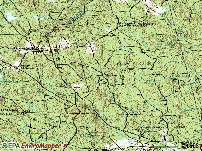
Points of interest:
Notable locations in Mason: Barrett Hill Farm (A), Mason Fire and Rescue (B). Display/hide their locations on the map
Church in Mason: Mason Congregational Church (A). Display/hide its location on the map
Cemeteries: Pratt Cemetery (1), Pleasant View Cemetery (2), Prospect Hill Cemetery (3). Display/hide their locations on the map
Reservoirs and swamps: Pratt Pond (A), Babb Swamp (B). Display/hide their locations on the map
Streams, rivers, and creeks: Rocky Brook (A), Black Brook (B). Display/hide their locations on the map
| This town: | 2.6 people |
| New Hampshire: | 2.5 people |
| This town: | 76.2% |
| Whole state: | 66.3% |
| This town: | 8.1% |
| Whole state: | 8.3% |
Likely homosexual households (counted as self-reported same-sex unmarried-partner households)
- Lesbian couples: 0.8% of all households
- Gay men: 0.0% of all households
| This town: | 3.4% |
| Whole state: | 6.5% |
| This town: | 2.3% |
| Whole state: | 2.8% |
For population 15 years and over in Mason:

- Never married: 20.5%
- Now married: 62.9%
- Separated: 2.5%
- Widowed: 6.0%
- Divorced: 8.2%
For population 25 years and over in Mason:
- High school or higher: 89.5%
- Bachelor's degree or higher: 30.9%
- Graduate or professional degree: 9.4%
- Unemployed: 5.4%
- Mean travel time to work (commute): 36.1 minutes


| Here: | 9.9 |
| New Hampshire average: | 10.9 |


Graphs represent county-level data. Detailed 2008 Election Results
Religion statistics for Mason, NH (based on Hillsborough County data)


| Religion | Adherents | Congregations |
|---|---|---|
| Catholic | 124,993 | 40 |
| Evangelical Protestant | 20,588 | 103 |
| Mainline Protestant | 17,794 | 60 |
| Other | 7,365 | 35 |
| Orthodox | 2,990 | 7 |
| Black Protestant | - | 1 |
| None | 226,991 | - |
Food Environment Statistics:
| This county: | 1.82 / 10,000 pop. |
| New Hampshire: | 2.14 / 10,000 pop. |
| This county: | 0.12 / 10,000 pop. |
| New Hampshire: | 0.15 / 10,000 pop. |
| Hillsborough County: | 1.65 / 10,000 pop. |
| State: | 1.78 / 10,000 pop. |
| This county: | 2.67 / 10,000 pop. |
| State: | 4.02 / 10,000 pop. |
| This county: | 8.23 / 10,000 pop. |
| New Hampshire: | 9.70 / 10,000 pop. |
| Hillsborough County: | 6.9% |
| New Hampshire: | 7.6% |
| This county: | 24.5% |
| New Hampshire: | 24.4% |
| Hillsborough County: | 15.1% |
| New Hampshire: | 15.9% |
6.73% of this county's 2021 resident taxpayers lived in other counties in 2020 ($92,767 average adjusted gross income)
| Here: | 6.73% |
| New Hampshire average: | 7.66% |
0.01% of residents moved from foreign countries ($183 average AGI)
Hillsborough County: 0.01% New Hampshire average: 0.01%
Top counties from which taxpayers relocated into this county between 2020 and 2021:
| from Middlesex County, MA | |
| from Rockingham County, NH | |
| from Merrimack County, NH |
6.49% of this county's 2020 resident taxpayers moved to other counties in 2021 ($81,100 average adjusted gross income)
| Here: | 6.49% |
| New Hampshire average: | 6.80% |
0.02% of residents moved to foreign countries ($105 average AGI)
Hillsborough County: 0.02% New Hampshire average: 0.01%
Top counties to which taxpayers relocated from this county between 2020 and 2021:
| to Rockingham County, NH | |
| to Merrimack County, NH | |
| to Middlesex County, MA |
Businesses in Mason, NH
- U-Haul: 1
Strongest AM radio stations in Mason:
- WRKO (680 AM; 50 kW; BOSTON, MA; Owner: ENTERCOM BOSTON LICENSE, LLC)
- WCRN (830 AM; 50 kW; WORCESTER, MA; Owner: CARTER BROADCASTING CORPORATION)
- WEEI (850 AM; 50 kW; BOSTON, MA; Owner: ENTERCOM BOSTON LICENSE, LLC)
- WKOX (1200 AM; 50 kW; FRAMINGHAM, MA; Owner: CAPSTAR TX LIMITED PARTNERSHIP)
- WEIM (1280 AM; 5 kW; FITCHBURG, MA; Owner: LIVEAIR COMMUNICATIONS, INC.)
- WBIX (1060 AM; 40 kW; NATICK, MA; Owner: LANGER BROADCASTING CORPORATION)
- WWZN (1510 AM; 50 kW; BOSTON, MA; Owner: ROSE CITY RADIO CORPORATION)
- WVNE (760 AM; daytime; 25 kW; LEICESTER, MA; Owner: BLOUNT MASSCOM, INC.)
- WFGL (960 AM; 2 kW; FITCHBURG, MA; Owner: CSN INTERNATIONAL)
- WAMG (890 AM; 25 kW; DEDHAM, MA; Owner: MEGA COMMUNICATIONS OF DEDHAM LICENSEE, LLC)
- WSMN (1590 AM; 5 kW; NASHUA, NH; Owner: 1590 BROADCASTING CORP.)
- WNNZ (640 AM; 50 kW; WESTFIELD, MA; Owner: CLEAR CHANNEL BROADCASTING LICENSES, INC.)
- WALE (990 AM; 50 kW; GREENVILLE, RI; Owner: NORTH AMERICAN BROADCASTING CO., INC.)
Strongest FM radio stations in Mason:
- WFEX (92.1 FM; PETERBOROUGH, NH; Owner: FNX BROADCASTING OF NEW HAMPSHIRE LLC)
- WGIR-FM (101.1 FM; MANCHESTER, NH; Owner: CAPSTAR TX LIMITED PARTNERSHIP)
- WQLL (96.5 FM; BEDFORD, NH; Owner: SAGA COMMUNICATIONS OF NEW ENGLAND, LLC)
- WLMW (90.7 FM; MANCHESTER, NH; Owner: KNOWLEDGE FOR LIFE)
- WZID (95.7 FM; MANCHESTER, NH; Owner: SAGA COMMUNICATIONS OF NEW ENGLAND, LLC)
- WXLO (104.5 FM; FITCHBURG, MA; Owner: CITADEL BROADCASTING COMPANY)
- WINQ (97.7 FM; WINCHENDON, MA; Owner: SAGA COMMUNICATIONS OF NEW ENGLAND, LLC)
- WHDQ (106.1 FM; CLAREMONT, NH; Owner: GREAT NORTHERN RADIO, L.L.C.)
- WAAF (107.3 FM; WORCESTER, MA; Owner: ENTERCOM BOSTON LICENSE, LLC)
- WHOB (106.3 FM; NASHUA, NH; Owner: TELE-MEDIA COMPANY OF NEW HAMPSHIRE, L.L.C.)
- WVPR (89.5 FM; WINDSOR, VT; Owner: VERMONT PUBLIC RADIO)
- WTPL (107.7 FM; HILLSBORO, NH; Owner: CONCORD BROADCASTING, L.L.C.)
- WSRS (96.1 FM; WORCESTER, MA; Owner: CAPSTAR TX LIMITED PARTNERSHIP)
- WBMX (98.5 FM; BOSTON, MA; Owner: INFINITY RADIO OPERATIONS INC.)
- WJMN (94.5 FM; BOSTON, MA; Owner: AMFM RADIO LICENSES, L.L.C.)
- WCRB (102.5 FM; WALTHAM, MA; Owner: CHARLES RIVER BROADCASTING WCRB LICE)
- WTKK (96.9 FM; BOSTON, MA; Owner: GREATER BOSTON RADIO, INC.)
- WROR-FM (105.7 FM; FRAMINGHAM, MA; Owner: GREATER BOSTON RADIO, INC.)
- WBOS (92.9 FM; BROOKLINE, MA; Owner: GREATER BOSTON RADIO, INC.)
- WKNE (103.7 FM; KEENE, NH; Owner: SAGA COMMUNICATIONS OF NEW ENGLAND, LLC)
TV broadcast stations around Mason:
- WUNI (Channel 27; WORCESTER, MA; Owner: ENTRAVISION HOLDINGS, LLC)
- WUTF (Channel 66; MARLBOROUGH, MA; Owner: TELEFUTURA BOSTON LLC)
- WCVB-TV (Channel 5; BOSTON, MA; Owner: WCVB HEARST-ARGYLE TV, INC.)
- WGBH-TV (Channel 2; BOSTON, MA; Owner: WGBH EDUCATIONAL FOUNDATION)
- WHDH-TV (Channel 7; BOSTON, MA; Owner: WHDH-TV)
- WNDS (Channel 50; DERRY, NH; Owner: CTV OF DERRY, INC)
- WMFP (Channel 62; LAWRENCE, MA; Owner: WSAH LICENSE, INC.)
- WBZ-TV (Channel 4; BOSTON, MA; Owner: VIACOM INC.)
- WGBX-TV (Channel 44; BOSTON, MA; Owner: WGBH EDUCATIONAL FOUNDATION)
- WFXZ-CA (Channel 24; BOSTON, MA; Owner: BOSTON BROADCASTING CORP.)
- WSBK-TV (Channel 38; BOSTON, MA; Owner: VIACOM INC.)
- WLVI-TV (Channel 56; CAMBRIDGE, MA; Owner: WLVI, INC.)
- WFXT (Channel 25; BOSTON, MA; Owner: FOX TELEVISION STATIONS INC.)
- WYDN (Channel 48; WORCESTER, MA; Owner: EDUCATIONAL PUBLIC TV CORPORATION)
- WBPX (Channel 68; BOSTON, MA; Owner: PAXSON BOSTON-68 LICENSE, INC.)
- W40BO (Channel 40; BOSTON, MA; Owner: PAXSON COMMUNICATIONS LPTV, INC.)
- WMUR-TV (Channel 9; MANCHESTER, NH; Owner: HEARST-ARGYLE PROPERTIES, INC.)
- W33AK (Channel 33; NASHUA, NH; Owner: CENTER B/CING CORPORATION OF NEW HAMPSHIRE)
- WYCN-LP (Channel 13; NASHUA, NH; Owner: CENTER BROADCASTING CORP. OF NEW HAMPSHIRE)
- Mason, New Hampshire
- Fatal accident count8
- Vehicles involved in fatal accidents10
- Fatal accidents involving drunk persons:2
- Fatalities9
- Persons involved in fatal accidents18
- Pedestrians involved in fatal accidents1
- New Hampshire average
- Fatal accident count1046
- Vehicles involved in fatal accidents1527
- Fatal accidents involving drunk persons470
- Fatalities1129
- Persons involved in fatal accidents2492
- Pedestrians involved in fatal accidents64
FCC Registered Broadcast Land Mobile Towers:
3- 7 Meetinghouse Hill Rd (Lat: 42.743417 Lon: -71.768694), Call Sign: WNBK693,
Assigned Frequencies: 155.565 MHz, Grant Date: 12/10/2014, Expiration Date: 01/16/2025, Registrant: Beltronics, Inc., 19 Proctor Hill Rd, Hollis, NH 03049, Phone: (603) 465-2422, Fax: (603) 465-3320, Email:
- Lat: 42.744444 Lon: -71.769167, Call Sign: WNDM753,
Assigned Frequencies: 153.747 MHz, Grant Date: 06/21/2022, Expiration Date: 07/18/2032, Certifier: Robert L Malboeuf, Registrant: Modular Communications, 932 Fitchburg Rd, Greenville, NH 03048, Phone: (603) 217-8946, Fax: (603) 878-0859, Email:
- Police Department (Lat: 42.840917 Lon: -71.733972), Call Sign: WXP331,
Assigned Frequencies: 155.475 MHz, 156.090 MHz, Grant Date: 02/10/2023, Expiration Date: 04/15/2033, Registrant: Nh Dept. Of Safety/Emergency Services And Communications, 33 Hazen Dr (Mailing), Concord, NH 03305, Phone: (603) 528-7541, Fax: (603) 271-6629, Email:
FCC Registered Amateur Radio Licenses:
41 (See the full list of FCC Registered Amateur Radio Licenses in Mason)FAA Registered Aircraft:
13 (See the full list of FAA Registered Aircraft in Mason)2002 - 2018 National Fire Incident Reporting System (NFIRS) incidents
- Fire incident types reported to NFIRS in Mason, NH
- 5445.4%Structure Fires
- 4840.3%Outside Fires
- 1210.1%Mobile Property/Vehicle Fires
- 54.2%Other
 According to the data from the years 2002 - 2018 the average number of fire incidents per year is 7. The highest number of reported fires - 16 took place in 2008, and the least - 0 in 2013. The data has a rising trend.
 When looking into fire subcategories, the most reports belonged to: Structure Fires (45.4%), and Outside Fires (40.3%).
- 64.5%Fuel oil, kerosene, etc.
- 17.3%Bottled, tank, or LP gas
- 13.1%Wood
- 2.4%Electricity
- 1.7%Coal or coke
- 0.5%Utility gas
- 0.5%Solar energy

- 90.9%Fuel oil, kerosene, etc.
- 9.1%Wood
Mason compared to New Hampshire state average:
- Unemployed percentage below state average.
- Black race population percentage significantly below state average.
- Hispanic race population percentage significantly below state average.
- Foreign-born population percentage below state average.
- Renting percentage significantly below state average.
- Length of stay since moving in significantly above state average.
- Number of rooms per house significantly below state average.
- House age significantly below state average.

|
|
Total of 73 patent applications in 2008-2024.