Clarendon, Vermont
Submit your own pictures of this town and show them to the world
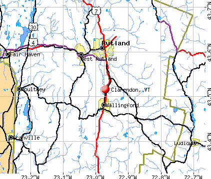
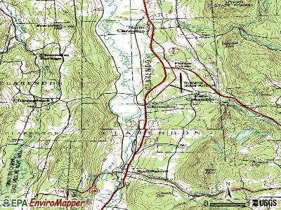
- OSM Map
- General Map
- Google Map
- MSN Map
Population change since 2000: -8.5%
 |
| Males: 1,291 | |
| Females: 1,280 |
| Median resident age: | 46.2 years |
| Vermont median age: | 45.8 years |
Zip codes: 05759.
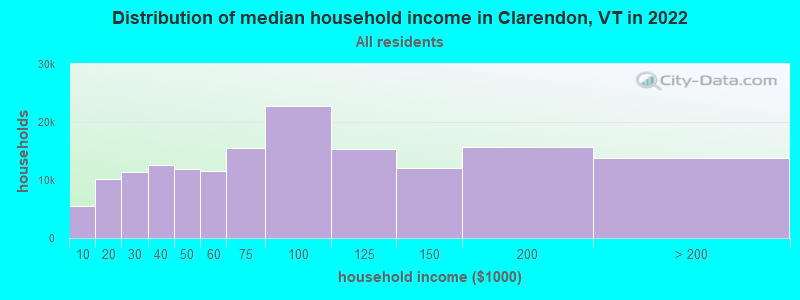
| Clarendon: | $70,894 |
| VT: | $73,991 |
Estimated per capita income in 2022: $39,184 (it was $19,801 in 2000)
Clarendon town income, earnings, and wages data
Estimated median house or condo value in 2022: $225,991 (it was $96,500 in 2000)
| Clarendon: | $225,991 |
| VT: | $304,700 |
Mean prices in 2022: all housing units: $254,868; detached houses: $264,391; townhouses or other attached units: $230,842; in 2-unit structures: $224,848; in 3-to-4-unit structures: $273,008; in 5-or-more-unit structures: $159,824; mobile homes: $117,051
Detailed information about poverty and poor residents in Clarendon, VT


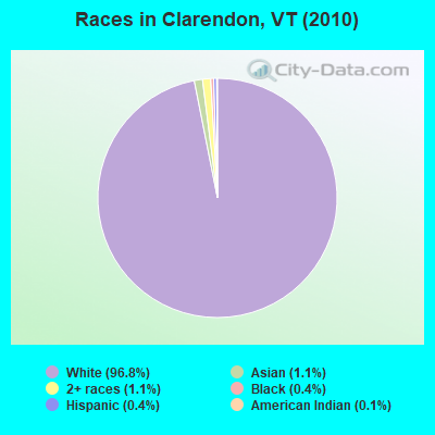
- 2,49096.8%White alone
- 291.1%Asian alone
- 281.1%Two or more races
- 100.4%Black alone
- 100.4%Hispanic
- 30.1%American Indian alone
- 10.04%Other race alone
Races in Clarendon detailed stats: ancestries, foreign born residents, place of birth
According to our research of Vermont and other state lists, there were 5 registered sex offenders living in Clarendon, Vermont as of June 08, 2024.
The ratio of all residents to sex offenders in Clarendon is 514 to 1.
The ratio of registered sex offenders to all residents in this city is near the state average.
 Recent articles from our blog. Our writers, many of them Ph.D. graduates or candidates, create easy-to-read articles on a wide variety of topics.

 | Official Vermont Picture Thread (966 replies) |
| What Are Your Thoughts on Proposed H.911? (28 replies) |
| Best Schools and towns around Rutland ? (7 replies) |
| Career move? to VT (Rutland area) from CT (34 replies) |
| Vermont Rail Ideas (125 replies) |
| Vermont Weather (3779 replies) |
Latest news from Clarendon, VT collected exclusively by city-data.com from local newspapers, TV, and radio stations
Ancestries: Irish (20.7%), English (18.5%), French (18.3%), United States (9.6%), German (8.3%), Italian (6.3%).
Current Local Time: EST time zone
Elevation: 556 feet
Land area: 31.6 square miles.
Population density: 81 people per square mile (very low).
45 residents are foreign born
| This town: | 1.6% |
| Vermont: | 3.8% |
| Clarendon town: | 1.9% ($1,866) |
| Vermont: | 2.0% ($2,196) |
Nearest city with pop. 50,000+: Schenectady, NY  (70.1 miles , pop. 61,821).
Nearest city with pop. 200,000+: Boston, MA (127.2 miles , pop. 589,141).
Nearest city with pop. 1,000,000+: Bronx, NY (191.8 miles , pop. 1,332,650).
Nearest cities:
), ), ), ), )Latitude: 43.54 N, Longitude: 72.97 W
Area code commonly used in this area: 802

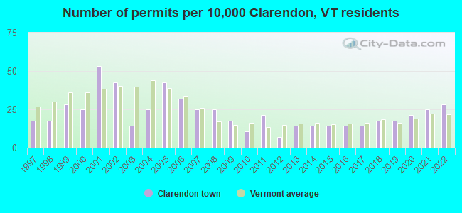
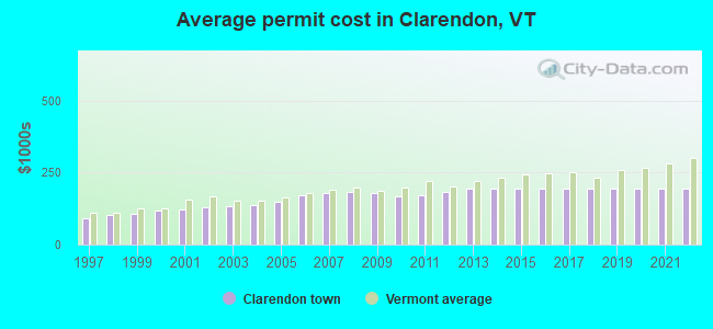
Single-family new house construction building permits:
- 2022: 8 buildings, average cost: $193,300
- 2021: 7 buildings, average cost: $193,300
- 2020: 6 buildings, average cost: $193,300
- 2019: 5 buildings, average cost: $193,300
- 2018: 5 buildings, average cost: $193,300
- 2017: 4 buildings, average cost: $193,300
- 2016: 4 buildings, average cost: $193,300
- 2015: 4 buildings, average cost: $193,300
- 2014: 4 buildings, average cost: $193,300
- 2013: 4 buildings, average cost: $193,300
- 2012: 2 buildings, average cost: $184,000
- 2011: 6 buildings, average cost: $172,800
- 2010: 3 buildings, average cost: $165,900
- 2009: 5 buildings, average cost: $178,900
- 2008: 7 buildings, average cost: $182,400
- 2007: 7 buildings, average cost: $181,200
- 2006: 9 buildings, average cost: $171,000
- 2005: 12 buildings, average cost: $150,200
- 2004: 7 buildings, average cost: $138,800
- 2003: 4 buildings, average cost: $132,800
- 2002: 12 buildings, average cost: $131,100
- 2001: 15 buildings, average cost: $121,400
- 2000: 7 buildings, average cost: $119,600
- 1999: 8 buildings, average cost: $107,300
- 1998: 5 buildings, average cost: $101,700
- 1997: 5 buildings, average cost: $90,800
| Here: | 2.5% |
| Vermont: | 2.0% |
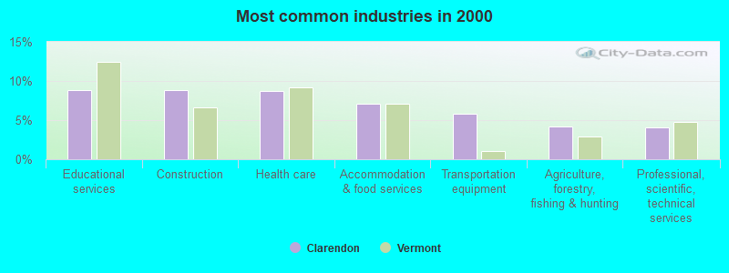
- Educational services (8.9%)
- Construction (8.8%)
- Health care (8.7%)
- Accommodation & food services (7.1%)
- Transportation equipment (5.8%)
- Agriculture, forestry, fishing & hunting (4.2%)
- Professional, scientific, technical services (4.1%)
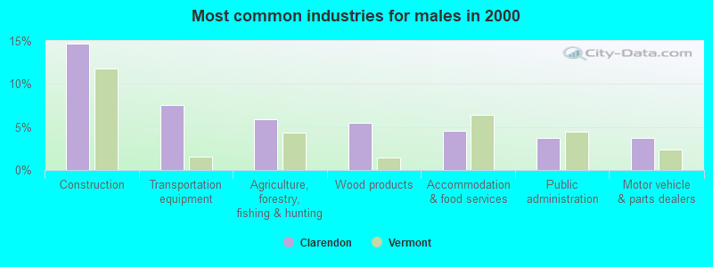
- Construction (14.7%)
- Transportation equipment (7.6%)
- Agriculture, forestry, fishing & hunting (5.9%)
- Wood products (5.5%)
- Accommodation & food services (4.5%)
- Public administration (3.7%)
- Motor vehicle & parts dealers (3.7%)
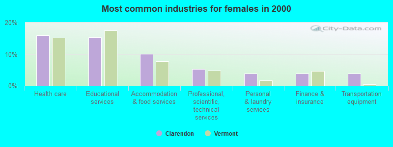
- Health care (15.9%)
- Educational services (15.4%)
- Accommodation & food services (10.1%)
- Professional, scientific, technical services (5.3%)
- Personal & laundry services (3.9%)
- Finance & insurance (3.8%)
- Transportation equipment (3.8%)
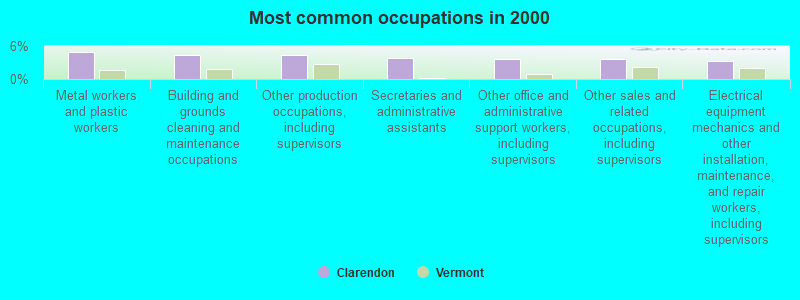
- Metal workers and plastic workers (4.9%)
- Building and grounds cleaning and maintenance occupations (4.3%)
- Other production occupations, including supervisors (4.3%)
- Secretaries and administrative assistants (3.7%)
- Other office and administrative support workers, including supervisors (3.6%)
- Other sales and related occupations, including supervisors (3.6%)
- Electrical equipment mechanics and other installation, maintenance, and repair workers, including supervisors (3.3%)
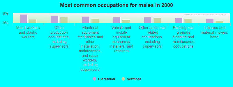
- Metal workers and plastic workers (7.2%)
- Other production occupations, including supervisors (6.0%)
- Electrical equipment mechanics and other installation, maintenance, and repair workers, including supervisors (5.7%)
- Vehicle and mobile equipment mechanics, installers, and repairers (4.9%)
- Other sales and related occupations, including supervisors (4.9%)
- Building and grounds cleaning and maintenance occupations (4.3%)
- Laborers and material movers, hand (3.8%)
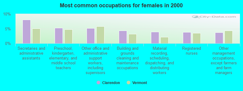
- Secretaries and administrative assistants (8.0%)
- Preschool, kindergarten, elementary, and middle school teachers (5.3%)
- Other office and administrative support workers, including supervisors (5.2%)
- Building and grounds cleaning and maintenance occupations (4.4%)
- Material recording, scheduling, dispatching, and distributing workers (3.9%)
- Registered nurses (3.8%)
- Other management occupations, except farmers and farm managers (3.7%)
Average climate in Clarendon, Vermont
Based on data reported by over 4,000 weather stations


(lower is better)
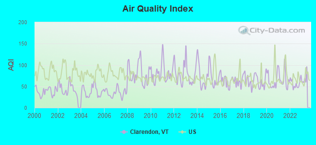
Air Quality Index (AQI) level in 2022 was 56.9. This is better than average.
| City: | 56.9 |
| U.S.: | 72.6 |
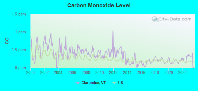
Carbon Monoxide (CO) [ppm] level in 2022 was 0.251. This is about average. Closest monitor was 4.8 miles away from the city center.
| City: | 0.251 |
| U.S.: | 0.251 |
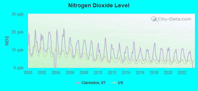
Nitrogen Dioxide (NO2) [ppb] level in 2022 was 6.51. This is worse than average. Closest monitor was 4.8 miles away from the city center.
| City: | 6.51 |
| U.S.: | 5.11 |
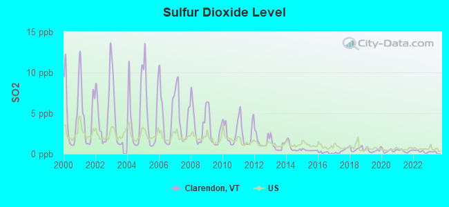
Sulfur Dioxide (SO2) [ppb] level in 2022 was 0.299. This is significantly better than average. Closest monitor was 4.5 miles away from the city center.
| City: | 0.299 |
| U.S.: | 1.515 |
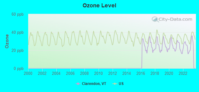
Ozone [ppb] level in 2022 was 23.5. This is significantly better than average. Closest monitor was 4.8 miles away from the city center.
| City: | 23.5 |
| U.S.: | 33.3 |
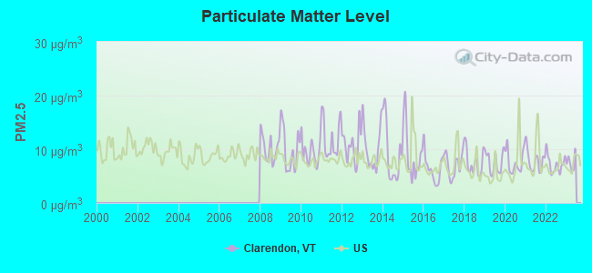
Particulate Matter (PM2.5) [µg/m3] level in 2022 was 7.23. This is about average. Closest monitor was 4.8 miles away from the city center.
| City: | 7.23 |
| U.S.: | 8.11 |
Tornado activity:
Clarendon-area historical tornado activity is slightly above Vermont state average. It is 68% smaller than the overall U.S. average.
On 8/20/1968, a category F3 (max. wind speeds 158-206 mph) tornado 31.5 miles away from the Clarendon town center injured one person and caused between $5000 and $50,000 in damages.
On 5/31/1998, a category F3 tornado 43.4 miles away from the town center injured 68 people and caused $71 million in damages.
Earthquake activity:
Clarendon-area historical earthquake activity is significantly above Vermont state average. It is 69% smaller than the overall U.S. average.On 10/7/1983 at 10:18:46, a magnitude 5.3 (5.1 MB, 5.3 LG, 5.1 ML, Class: Moderate, Intensity: VI - VII) earthquake occurred 74.2 miles away from the city center
On 4/20/2002 at 10:50:47, a magnitude 5.3 (5.3 ML, Depth: 3.0 mi) earthquake occurred 76.4 miles away from the city center
On 4/20/2002 at 10:50:47, a magnitude 5.2 (5.2 MB, 4.2 MS, 5.2 MW, 5.0 MW) earthquake occurred 75.4 miles away from the city center
On 1/19/1982 at 00:14:42, a magnitude 4.7 (4.5 MB, 4.7 MD, 4.5 LG, Class: Light, Intensity: IV - V) earthquake occurred 68.9 miles away from the city center
On 10/16/2012 at 23:12:25, a magnitude 4.7 (4.7 ML, Depth: 10.0 mi) earthquake occurred 116.1 miles away from the city center
On 6/17/1991 at 08:53:16, a magnitude 4.1 (4.0 MB, 4.0 LG, Depth: 3.1 mi) earthquake occurred 106.7 miles away from the city center
Magnitude types: regional Lg-wave magnitude (LG), body-wave magnitude (MB), duration magnitude (MD), local magnitude (ML), surface-wave magnitude (MS), moment magnitude (MW)
Natural disasters:
The number of natural disasters in Rutland County (16) is near the US average (15).Major Disasters (Presidential) Declared: 11
Emergencies Declared: 2
Causes of natural disasters: Floods: 9, Storms: 9, Tropical Storms: 2, Winter Storms: 2, Hurricane: 1, Landslide: 1, Snowstorm: 1, Wind: 1, Other: 1 (Note: some incidents may be assigned to more than one category).
Hospitals and medical centers near Clarendon:
- VERMONT ACHIEVEMENT CENTER (Nursing Home, about 4 miles away; RUTLAND, VT)
- MOUNTAIN VIEW CENTER GENESIS HEALTHCARE (Nursing Home, about 4 miles away; RUTLAND, VT)
- THE PINES AT RUTLAND CENTER FOR NURSING AND REHABI (Nursing Home, about 5 miles away; RUTLAND, VT)
- FLETCHER ALLEN HEALTHCARE - RRMC SATELLITE (Dialysis Facility, about 5 miles away; RUTLAND, VT)
- RUTLAND REGIONAL MEDICAL CENTER Acute Care Hospitals (about 5 miles away; RUTLAND, VT)
- RUTLAND AREA VNA (Home Health Center, about 5 miles away; RUTLAND, VT)
- RUTLAND HEALTHCARE AND REHABILITATION CENTER (Nursing Home, about 6 miles away; RUTLAND, VT)
Amtrak stations near Clarendon:
- 5 miles: RUTLAND (MERCHANTS ROW) . Services: ticket office, fully wheelchair accessible, enclosed waiting area, public restrooms, public payphones, vending machines, free short-term parking, free long-term parking, call for car rental service, call for taxi service, intercity bus service, public transit connection.
- 13 miles: KILLINGTON (RTE 4) - Seasonal Bus Station . Services: fully wheelchair accessible, enclosed waiting area, public payphones, snack bar, free short-term parking, call for car rental service, call for taxi service, public transit connection.
- 15 miles: FAIR HAVEN (DEPOT & WATER STS.)
Colleges/universities with over 2000 students nearest to Clarendon:
- Castleton State College (about 12 miles; Castleton, VT; Full-time enrollment: 2,079)
- Middlebury College (about 35 miles; Middlebury, VT; FT enrollment: 3,077)
- Dartmouth College (about 37 miles; Hanover, NH; FT enrollment: 6,030)
- Adirondack Community College (about 37 miles; Queensbury, NY; FT enrollment: 2,826)
- Norwich University (about 45 miles; Northfield, VT; FT enrollment: 4,221)
- Skidmore College (about 52 miles; Saratoga Springs, NY; FT enrollment: 2,753)
- SUNY Empire State College (about 52 miles; Saratoga Springs, NY; FT enrollment: 9,473)
Public high school in Clarendon:
- MILL RIVER USD #40 (Students: 715, Location: 2321 MIDDLE ROAD, Grades: 7-12)
Public elementary/middle school in Clarendon:
- CLARENDON ELEMENTARY SCHOOL (Students: 242, Location: 84 GRANGE HALL ROAD, Grades: PK-6)
Points of interest:
Notable locations in Clarendon: Iroquois Land Family Campground (A), Clarendon Town Hall (B), Clarendon Volunteer Fire Association Station 2 (C), Clarendon Volunteer Fire Association Station 1 (D). Display/hide their locations on the map
Churches in Clarendon include: Union Chapel (A), Clarendon Congregational Church (B). Display/hide their locations on the map
Cemeteries: Potter Cemetery (1), Joseph Wait Cemetery (2), East Clarenden Cemetery (3), Clarendon Flats Cemetery (4), Edmunds Cemetery (5), Old Marsh Cemetery (6), Parker Cemetery (7). Display/hide their locations on the map
Streams, rivers, and creeks: Mill River (A), Ira Brook (B). Display/hide their locations on the map
Birthplace of: Charles V. Dyer - Abolitionist, George F. Emmons - Navy admiral.
| This town: | 2.4 people |
| Vermont: | 2.3 people |
| This town: | 65.5% |
| Whole state: | 62.5% |
| This town: | 9.9% |
| Whole state: | 9.2% |
Likely homosexual households (counted as self-reported same-sex unmarried-partner households)
- Lesbian couples: 0.7% of all households
- Gay men: 0.4% of all households
| This town: | 7.7% |
| Whole state: | 9.4% |
| This town: | 2.3% |
| Whole state: | 3.6% |
For population 15 years and over in Clarendon:
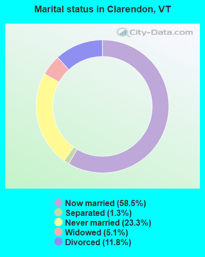
- Never married: 23.3%
- Now married: 58.5%
- Separated: 1.3%
- Widowed: 5.1%
- Divorced: 11.8%
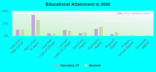
For population 25 years and over in Clarendon:
- High school or higher: 87.0%
- Bachelor's degree or higher: 20.0%
- Graduate or professional degree: 5.2%
- Unemployed: 3.3%
- Mean travel time to work (commute): 18.2 minutes

| Here: | 9.7 |
| Vermont average: | 11.7 |
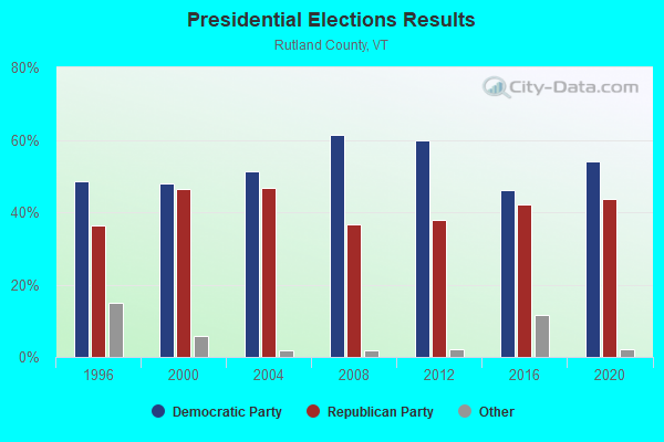
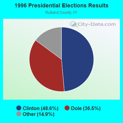
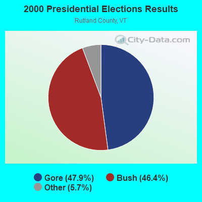
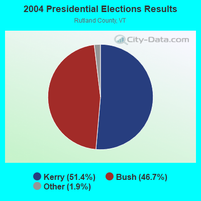
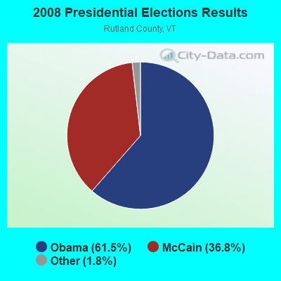
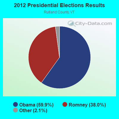
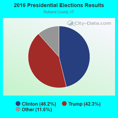
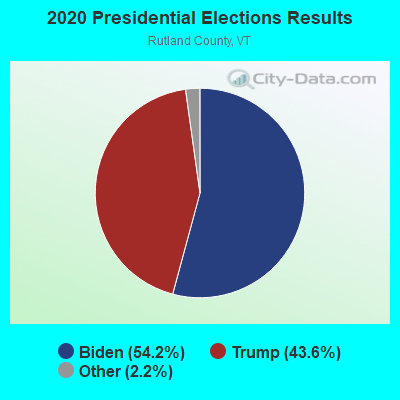
Graphs represent county-level data. Detailed 2008 Election Results
Religion statistics for Clarendon, VT (based on Rutland County data)

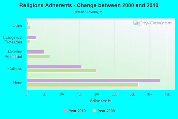
| Religion | Adherents | Congregations |
|---|---|---|
| Catholic | 15,500 | 17 |
| Mainline Protestant | 4,944 | 38 |
| Evangelical Protestant | 2,587 | 36 |
| Other | 520 | 5 |
| Orthodox | 85 | 1 |
| None | 38,006 | - |
Food Environment Statistics:
| Rutland County: | 3.78 / 10,000 pop. |
| State: | 3.84 / 10,000 pop. |
| This county: | 2.05 / 10,000 pop. |
| Vermont: | 1.95 / 10,000 pop. |
| Here: | 7.56 / 10,000 pop. |
| Vermont: | 6.40 / 10,000 pop. |
| Rutland County: | 12.77 / 10,000 pop. |
| Vermont: | 11.52 / 10,000 pop. |
| Rutland County: | 7.8% |
| Vermont: | 6.8% |
| Rutland County: | 24.1% |
| Vermont: | 22.3% |
| This county: | 18.5% |
| Vermont: | 13.3% |
Strongest AM radio stations in Clarendon:
- WSYB (1380 AM; 5 kW; RUTLAND, VT; Owner: CAPSTAR TX LIMITED PARTNERSHIP)
- WGY (810 AM; 50 kW; SCHENECTADY, NY; Owner: CLEAR CHANNEL BROADCASTING LICENSES, INC.)
- WNNZ (640 AM; 50 kW; WESTFIELD, MA; Owner: CLEAR CHANNEL BROADCASTING LICENSES, INC.)
- WPTR (1540 AM; 50 kW; ALBANY, NY; Owner: KIMTRON, INC.)
- WNTK (1020 AM; 10 kW; NEWPORT, NH; Owner: KOOR COMMUNICATIONS, INC.)
- WCRN (830 AM; 50 kW; WORCESTER, MA; Owner: CARTER BROADCASTING CORPORATION)
- WVNR (1340 AM; 1 kW; POULTNEY, VT; Owner: PINE TREE BROADCASTING COMPANY)
- WRKO (680 AM; 50 kW; BOSTON, MA; Owner: ENTERCOM BOSTON LICENSE, LLC)
- WCHP (760 AM; 35 kW; CHAMPLAIN, NY; Owner: CHAMPLAIN RADIO, INC.)
- WNBX (1480 AM; 5 kW; SPRINGFIELD, VT)
- WEEI (850 AM; 50 kW; BOSTON, MA; Owner: ENTERCOM BOSTON LICENSE, LLC)
- WVNE (760 AM; daytime; 25 kW; LEICESTER, MA; Owner: BLOUNT MASSCOM, INC.)
- WTIC (1080 AM; 50 kW; HARTFORD, CT; Owner: INFINITY RADIO OPERATIONS INC.)
Strongest FM radio stations in Clarendon:
- WJJR (98.1 FM; RUTLAND, VT; Owner: 6 JOHNSON ROAD LICENSES, INC.)
- WZRT (97.1 FM; RUTLAND, VT; Owner: CAPSTAR TX LIMITED PARTNERSHIP)
- WEBK (105.3 FM; KILLINGTON, VT; Owner: 6 JOHNSON ROAD LICENSES, INC.)
- WGLV (91.7 FM; WOODSTOCK, VT; Owner: CHRISTIAN MINISTRIES INC)
- WHDQ-FM1 (106.1 FM; RUTLAND, VT; Owner: GREAT NORTHERN RADIO, L.L.C.)
- WEQX (102.7 FM; MANCHESTER, VT; Owner: NORTHSHIRE COMMUNICATIONS, INC.)
- WJEN (94.5 FM; RUTLAND, VT; Owner: 6 JOHNSON ROAD LICENSES, INC.)
- WJAN (95.1 FM; SUNDERLAND, VT; Owner: 6 JOHNSON ROAD LICENSES, INC.)
- WVPR (89.5 FM; WINDSOR, VT; Owner: VERMONT PUBLIC RADIO)
- WEXP (101.5 FM; BRANDON, VT; Owner: VOX VERMONT, L.L.C.)
- WHDQ (106.1 FM; CLAREMONT, NH; Owner: GREAT NORTHERN RADIO, L.L.C.)
- WDEV-FM (96.1 FM; WARREN, VT; Owner: RADIO VERMONT, INC.)
- WNGN (91.9 FM; ARGYLE, NY; Owner: NORTHEAST GOSPEL BROADCASTING INC)
- WCVT (101.7 FM; STOWE, VT; Owner: RADIO VERMONT CLASSICS, L.L.C.)
- WVAY (100.7 FM; WILMINGTON, VT; Owner: GREAT NORTHERN RADIO, L.L.C.)
- WLJH (90.9 FM; GLENS FALLS, NY; Owner: SOUND OF LIFE INC)
- WMXR (93.9 FM; WOODSTOCK, VT; Owner: CLEAR CHANNEL BROADCASTING LICENSES, INC.)
- WVPS (107.9 FM; BURLINGTON, VT; Owner: VERMONT PUBLIC RADIO)
- WVRR (101.7 FM; NEWPORT, NH; Owner: CAPSTAR TX LIMITED PARTNERSHIP)
- WXLG (89.9 FM; NORTH CREEK, NY; Owner: THE ST. LAWRENCE UNIVERSITY)
TV broadcast stations around Clarendon:
- W69AR (Channel 69; RUTLAND, VT; Owner: MT. MANSFIELD TELEVISION, INC.)
- W07AG (Channel 7; RUTLAND, VT; Owner: WNYT INC.)
- WVER (Channel 28; RUTLAND, VT; Owner: VERMONT ETV, INC.)
- W61CE (Channel 61; RUTLAND, VT; Owner: MARGARET SANGUINETTI (ADMINISTRATRIX OF THE ESTATE))
- WVTA (Channel 41; WINDSOR, VT; Owner: VERMONT ETV, INC.)
- W18AE (Channel 18; KILLINGTON, VT; Owner: KILLINGTON, LTD.)
- National Bridge Inventory (NBI) Statistics
- 16Number of bridges
- 177ft / 54.1mTotal length
- $11,505,000Total costs
- 38,649Total average daily traffic
- 3,287Total average daily truck traffic
- 40,583Total future (year 2027) average daily traffic
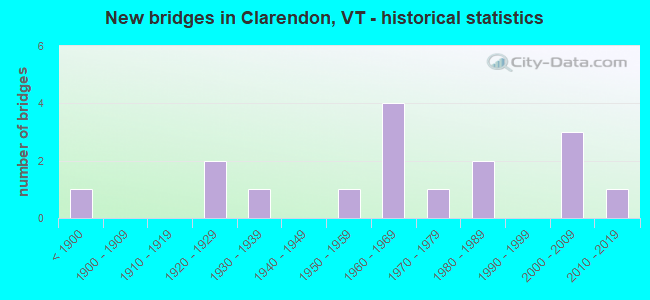
- New bridges - historical statistics
- 1Before 1900
- 21920-1929
- 11930-1939
- 11950-1959
- 41960-1969
- 11970-1979
- 21980-1989
- 32000-2009
- 12010-2019
FCC Registered Broadcast Land Mobile Towers:
2- Lat: 43.564139 Lon: -72.968000, Call Sign: WQUK590,
Assigned Frequencies: 156.172 MHz, Grant Date: 08/04/2014, Expiration Date: 08/04/2024, Certifier: Norm Flanders, Registrant: Cara Enterprises Inc, Las Vegas, NV 89140-0124, Phone: (702) 838-9728, Fax: (702) 363-4607, Email:
- Lat: 43.564139 Lon: -72.968000, Call Sign: WQUS920,
Assigned Frequencies: 173.225 MHz, Grant Date: 10/01/2014, Expiration Date: 10/01/2024, Certifier: Norm Flanders, Registrant: Cara Enterprises Inc, Las Vegas, NV 89140-0124, Phone: (702) 838-9728, Fax: (702) 363-4607, Email:
FCC Registered Microwave Towers:
1- Raiche Hill 1.5 Mi Se Of (Lat: 43.505056 Lon: -72.996750), Structure height: 18.6 m, Overall height: 13.7 m, Call Sign: WFD468,
Assigned Frequencies: 6900.00 MHz, Grant Date: 02/14/1979, Expiration Date: 04/01/1984, Cancellation Date: 06/11/2000, Registrant: Taft Broadcasting Corporation, Pines Motel, White River Junction, VT 05001
FCC Registered Amateur Radio Licenses:
2- Call Sign: N1WUD, Licensee ID: L00238655, Grant Date: 06/14/2016, Expiration Date: 03/13/2026, Certifier: Jeffrey M Priest, Registrant: Jeffrey M Priest, 795 Walker Mnt Rd, N Clarendon, VT 05759
- Call Sign: KB1LKT, Licensee ID: L00880475, Grant Date: 06/18/2004, Expiration Date: 06/18/2014, Cancellation Date: 06/21/2016, Certifier: Thomas L May, Registrant: Thomas L May, Clarendon, VT 05759
FAA Registered Aircraft:
1- Aircraft: MOONEY AIRCRAFT CORP. M20K (Category: Land, Seats: 4, Weight: Up to 12,499 Pounds), Engine: CONT MOTOR TSIO-360 SER (225 HP) (Reciprocating)
N-Number: 1167J, N1167J, N-1167J, Serial Number: 25-0690, Year manufactured: 1982, Airworthiness Date: 12/10/1982, Certificate Issue Date: 05/11/2012
Registrant (Co-Owned): Curtis W Mcmillion, 63 Sunny Hill Dr, Clarendon, VT 05759, Other Owners: Kimber R Mcmillion
Deregistered: Cancel Date: 02/08/2018
2002 - 2018 National Fire Incident Reporting System (NFIRS) incidents
- Fire incident types reported to NFIRS in Clarendon, VT
- 7862.9%Structure Fires
- 2923.4%Outside Fires
- 108.1%Other
- 75.6%Mobile Property/Vehicle Fires
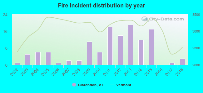 According to the data from the years 2002 - 2018 the average number of fire incidents per year is 7. The highest number of fires - 19 took place in 2013, and the least - 0 in 2016. The data has an increasing trend.
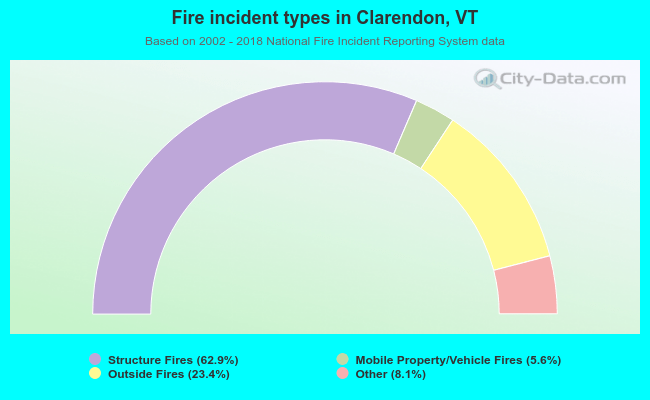 When looking into fire subcategories, the most reports belonged to: Structure Fires (62.9%), and Outside Fires (23.4%).
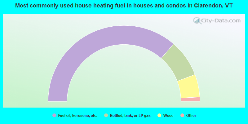
- 72.7%Fuel oil, kerosene, etc.
- 15.8%Bottled, tank, or LP gas
- 9.7%Wood
- 1.2%Electricity
- 0.4%Coal or coke
- 0.2%Other fuel
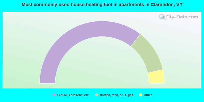
- 71.0%Fuel oil, kerosene, etc.
- 21.9%Bottled, tank, or LP gas
- 2.9%Wood
- 2.4%Utility gas
- 1.9%Electricity
Clarendon compared to Vermont state average:
- Unemployed percentage significantly below state average.
- Black race population percentage below state average.
- Hispanic race population percentage significantly below state average.
- Foreign-born population percentage significantly below state average.
- Renting percentage below state average.
- Length of stay since moving in significantly above state average.
- Number of rooms per house significantly below state average.
- House age significantly below state average.
- Number of college students below state average.
- Percentage of population with a bachelor's degree or higher below state average.

|
Total of 1 patent application in 2008-2024.