Bridge Statistics for Urbana, Maryland (MD)
Condition, Traffic, Stress, Structural Evaluation, Project Costs
- National Bridge Inventory (NBI) Statistics
- 32Number of bridges
- 180ft / 54.8mTotal length
- $2,127,000Total costs
- 953,726Total average daily traffic
- 64,143Total average daily truck traffic
- National Bridge Inventory (NBI) Registered Bridges for Urbana
- No street view available for this location
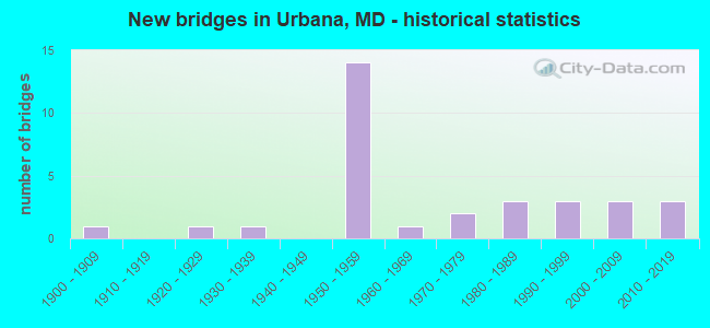
- New bridges - historical statistics
- 11900-1909
- 11920-1929
- 11930-1939
- 141950-1959
- 11960-1969
- 21970-1979
- 31980-1989
- 31990-1999
- 32000-2009
- 32010-2019

- Reconstructed bridges - Historical Statistics
- 51990-1999
- 62000-2009
- 22010-2019
- 12020-2022


- Bridge Condition - Deck
- 15.0%Very good
- 75.0%Good
- 10.0%Satisfactory

- Bridge Condition - Superstructure
- 15.0%Very good
- 60.0%Good
- 25.0%Satisfactory

- Bridge Condition - Substructure
- 30.0%Very good
- 25.0%Good
- 45.0%Satisfactory

- Bridge Condition - Channel
- 8.7%Very good
- 43.5%Good
- 43.5%Satisfactory
- 4.3%Fair

- Bridge Condition - Culverts
- 66.7%Good
- 33.3%Satisfactory
Find on map >> Show street view
Structure Number: 10000010004701, Location: 1.62 MILES N OF MD 355 (Lat: 39.308972, Lng: -77.298550), Route carried "on" structure: State highway 75, Year Built: 1974, Status: Open, Structure Length: 2.26m (7.41ft), Average Daily Traffic: 7,952 (year 2009), Truck Traffic: 8%, Average Future Daily Traffic: 9,653 (year 2026), Design Load: HS 20, Features Intersected: BENNETT CREEK
Minimum Vertical Clearance: 30+ m (98+ ft), Kilometerpoint: 2.607, Lanes on structure: 2, Owner: State Highway Agency, Approaching Roadway Width: 11.0m (36.1ft), Material/Design: Steel, Design/Construction: Stringer/Multi-beam, Number Of Spans In Main Unit: 1, Length of Maximum Span: 21.3m (69.9ft), Curb-To-Curb Width: 11.4m (37.4ft), Out-to-Out Width: 12.3m (40.4ft)
Condition: Deck: Satisfactory, Superstructure: Satisfactory, Substructure: Satisfactory, Channel: Satisfactory, Operating Rating: 89.3 metric tons, Method Used To Determine Operating Rating: Load Factor (LF), Inventory Rating: 53.5 metric tons, Method Used To Determine Inventory Rating: Load Factor (LF), Structural Evaluation: Equal to present minimum criteria, Deck Geometry: Meets minimum limits, Waterway Adequacy: Equal to present desirable criteria, Approach Roadway Alignment: Equal to present desirable criteria, Designated Inspection Frequency: Every 24 months, Inspection Date: July 2021, Deck Structure Type: Concrete Cast-file-Place, Wearing Surface/Protective System: Wearing Surface: Monolithic Concrete
Find on map >> Show street view
Structure Number: 100000100078011, Location: 3.52 MILES N OF MONT CO (Lat: 39.323539, Lng: -77.356800), Route carried "on" structure: Interstate 270, Year Built: 1950, Year Reconstructed: 2012, Status: Open, Structure Length: 1.95m (6.40ft), Average Daily Traffic: 81,890 (year 2011), Truck Traffic: 9%, Average Future Daily Traffic: 110,800 (year 2029), Design Load: HS 20, Features Intersected: MD 80
Minimum Vertical Clearance: 30+ m (98+ ft), Kilometerpoint: 5.654, Lanes on structure: 3, Lanes under structure: 4, Base Highway Network: Yes, Owner: State Highway Agency, Approaching Roadway Width: 13.1m (43.0ft), Skew: 3 degrees, Material/Design: Steel, Design/Construction: Stringer/Multi-beam, Number Of Spans In Main Unit: 1, Length of Maximum Span: 18.0m (59.1ft), Curb-To-Curb Width: 13.3m (43.6ft), Out-to-Out Width: 14.2m (46.6ft)
Condition: Deck: Good, Superstructure: Satisfactory, Substructure: Satisfactory, Inventory Rating: 65.8 metric tons, Method Used To Determine Inventory Rating: Load Factor (LF), Structural Evaluation: Equal to present minimum criteria, Deck Geometry: High priority of replacement, Underclear: High priority of corrective action, Approach Roadway Alignment: Equal to present desirable criteria, Length Of Structure Improvement: 1.92m (6.30ft), Designated Inspection Frequency: Every 24 months, Inspection Date: January 2021, Bridge Improvement Cost: $161,000, Roadway Improvement Cost: $16,000, Total Project Cost: $177,000, Deck Structure Type: Concrete Cast-file-Place, Wearing Surface/Protective System: Wearing Surface: Integral Concrete
Find on map >> Show street view
Structure Number: 100000100078012, Location: 3.52 MILES N OF MONT CO (Lat: 39.323492, Lng: -77.357250), Route carried "on" structure: Interstate 270, Year Built: 1950, Year Reconstructed: 2012, Status: Open, Structure Length: 1.95m (6.40ft), Average Daily Traffic: 81,890 (year 2011), Truck Traffic: 9%, Average Future Daily Traffic: 110,800 (year 2029), Features Intersected: MD 80
Minimum Vertical Clearance: 30+ m (98+ ft), Kilometerpoint: 5.664, Lanes on structure: 3, Lanes under structure: 4, Base Highway Network: Yes, Owner: State Highway Agency, Approaching Roadway Width: 12.8m (42.0ft), Skew: 3 degrees, Material/Design: Steel, Design/Construction: Stringer/Multi-beam, Number Of Spans In Main Unit: 1, Length of Maximum Span: 18.0m (59.1ft), Curb-To-Curb Width: 13.3m (43.6ft), Out-to-Out Width: 14.2m (46.6ft)
Condition: Deck: Good, Superstructure: Good, Substructure: Satisfactory, Inventory Rating: 59.9 metric tons, Method Used To Determine Inventory Rating: Load Factor (LF), Structural Evaluation: Equal to present minimum criteria, Deck Geometry: High priority of replacement, Underclear: High priority of corrective action, Approach Roadway Alignment: Equal to present desirable criteria, Length Of Structure Improvement: 1.92m (6.30ft), Designated Inspection Frequency: Every 24 months, Inspection Date: January 2021, Bridge Improvement Cost: $161,000, Roadway Improvement Cost: $16,000, Total Project Cost: $177,000, Deck Structure Type: Concrete Cast-file-Place, Wearing Surface/Protective System: Wearing Surface: Integral Concrete
Find on map >> Show street view
Structure Number: 100000100079011, Location: 1.26 MI. N. OF MD 80 (Lat: 39.308289, Lng: -77.345381), Route carried "on" structure: Interstate 270, Year Built: 1950, Year Reconstructed: 2012, Status: Open, Structure Length: 2.41m (7.91ft), Average Daily Traffic: 88,192 (year 2019), Truck Traffic: 9%, Average Future Daily Traffic: 48,623 (year 2039), Design Load: HS 20, Features Intersected: BENNETT CREEK
Minimum Vertical Clearance: 30+ m (98+ ft), Kilometerpoint: 3.636, Lanes on structure: 2, Base Highway Network: Yes, Owner: State Highway Agency, Approaching Roadway Width: 11.9m (39.0ft), Material/Design: Steel, Design/Construction: Stringer/Multi-beam, Number Of Spans In Main Unit: 1, Length of Maximum Span: 22.9m (75.1ft), Curb-To-Curb Width: 11.7m (38.4ft), Out-to-Out Width: 13.0m (42.7ft)
Condition: Deck: Good, Superstructure: Satisfactory, Substructure: Satisfactory, Channel: Satisfactory, Operating Rating: 84.8 metric tons, Method Used To Determine Operating Rating: Load Factor (LF), Inventory Rating: 50.8 metric tons, Method Used To Determine Inventory Rating: Load Factor (LF), Structural Evaluation: Equal to present minimum criteria, Deck Geometry: Equal to present minimum criteria, Waterway Adequacy: Superior to present desirable criteria, Approach Roadway Alignment: Equal to present desirable criteria, Designated Inspection Frequency: Every 24 months, Inspection Date: March 2021, Deck Structure Type: Concrete Cast-file-Place, Wearing Surface/Protective System: Wearing Surface: Integral Concrete
Find on map >> Show street view
Structure Number: 100000100079012, Location: 1.26 MI. N. OF MD 80 (Lat: 39.308175, Lng: -77.345894), Route carried "on" structure: Interstate 270, Year Built: 1950, Year Reconstructed: 2012, Status: Open, Structure Length: 2.41m (7.91ft), Average Daily Traffic: 88,192 (year 2019), Truck Traffic: 9%, Average Future Daily Traffic: 48,623 (year 2039), Design Load: HS 20, Features Intersected: BENNETT CREEK
Minimum Vertical Clearance: 30+ m (98+ ft), Kilometerpoint: 3.636, Lanes on structure: 2, Base Highway Network: Yes, Owner: State Highway Agency, Approaching Roadway Width: 11.9m (39.0ft), Material/Design: Steel, Design/Construction: Stringer/Multi-beam, Number Of Spans In Main Unit: 1, Length of Maximum Span: 22.9m (75.1ft), Curb-To-Curb Width: 11.7m (38.4ft), Out-to-Out Width: 13.0m (42.7ft)
Condition: Deck: Good, Superstructure: Satisfactory, Substructure: Satisfactory, Channel: Satisfactory, Operating Rating: 84.8 metric tons, Method Used To Determine Operating Rating: Load Factor (LF), Inventory Rating: 50.8 metric tons, Method Used To Determine Inventory Rating: Load Factor (LF), Structural Evaluation: Equal to present minimum criteria, Deck Geometry: Equal to present minimum criteria, Waterway Adequacy: Superior to present desirable criteria, Approach Roadway Alignment: Equal to present desirable criteria, Designated Inspection Frequency: Every 24 months, Inspection Date: March 2021, Deck Structure Type: Concrete Cast-file-Place, Wearing Surface/Protective System: Wearing Surface: Integral Concrete
Find on map >> Show street view
Structure Number: 10000010008001, Location: 1.18 MILES N OF MONT CO (Lat: 39.295839, Lng: -77.333858), Route carried "on" structure: Interstate 270, Year Built: 2010, Status: Open, Structure Length: 2.44m (8.01ft), Average Daily Traffic: 87,230 (year 2009), Truck Traffic: 9%, Average Future Daily Traffic: 119,700 (year 2025), Features Intersected: DR PERRY RD
Minimum Vertical Clearance: 30+ m (98+ ft), Kilometerpoint: 1.899, Lanes on structure: 4, Lanes under structure: 2, Base Highway Network: Yes, Owner: State Highway Agency, Approaching Roadway Width: 10.4m (34.1ft), Skew: 12 degrees, Material/Design: Steel, Design/Construction: Stringer/Multi-beam, Number Of Spans In Main Unit: 1, Length of Maximum Span: 22.9m (75.1ft), Curb-To-Curb Width: 36.6m (120.1ft), Out-to-Out Width: 38.8m (127.3ft)
Condition: Deck: Good, Superstructure: Very good, Substructure: Very good, Inventory Rating: 67.1 metric tons, Method Used To Determine Inventory Rating: Load Factor (LF), Structural Evaluation: Equal to present desirable criteria, Deck Geometry: Superior to present desirable criteria, Underclear: Meets minimum limits, Approach Roadway Alignment: Equal to present desirable criteria, Designated Inspection Frequency: Every 24 months, Inspection Date: March 2020, Deck Structure Type: Concrete Cast-file-Place, Wearing Surface/Protective System: Wearing Surface: Integral Concrete, Deck Protection: Epoxy Coated Reinforcing
Find on map >> Show street view
Structure Number: 10000010017402, Location: 0.21 M S OF BR NO 1017900 (Lat: 39.306275, Lng: -77.342569), Route carried "on" structure: Interstate 270, Year Built: 1951, Status: Open, Structure Length: 0.63m (2.07ft), Average Daily Traffic: 86,751 (year 2013), Average Future Daily Traffic: 48,623 (year 2026), Design Load: HS 20+Mod, Features Intersected: BRANCH OF BENNETT CREEK
Minimum Vertical Clearance: 30+ m (98+ ft), Kilometerpoint: 3.298, Lanes on structure: 4, Base Highway Network: Yes, Owner: State Highway Agency, Approaching Roadway Width: 36.6m (120.1ft), Skew: 3 degrees, Material/Design: Concrete, Design/Construction: Culvert, Length of Maximum Span: 3.0m (9.8ft)
Condition: Channel: Satisfactory, Culverts: Satisfactory, Operating Rating: 85.3 metric tons, Method Used To Determine Operating Rating: Load Factor (LF), Inventory Rating: 51.2 metric tons, Method Used To Determine Inventory Rating: Load Factor (LF), Structural Evaluation: Equal to present minimum criteria, Waterway Adequacy: Better than present minimum criteria, Approach Roadway Alignment: Equal to present desirable criteria, Designated Inspection Frequency: Every 24 months, Inspection Date: August 2021
Find on map >> Show street view
Structure Number: 100000150036011, Location: 0.22 MI S OF FREDERICK CO (Lat: 39.277667, Lng: -77.323278), Route carried "on" structure: Interstate 270, Year Built: 1950, Year Reconstructed: 2001, Status: Open, Structure Length: 5.12m (16.80ft), Average Daily Traffic: 87,230 (year 2009), Truck Traffic: 9%, Average Future Daily Traffic: 129,790 (year 2029), Design Load: HS 25 or greater, Features Intersected: MD 109, LITTLE BENNETT C
Minimum Vertical Clearance: 30+ m (98+ ft), Kilometerpoint: 35.849, Lanes on structure: 2, Lanes under structure: 2, Base Highway Network: Yes, Owner: State Highway Agency, Approaching Roadway Width: 14.0m (45.9ft), Material/Design: Steel continuous, Design/Construction: Stringer/Multi-beam, Number Of Spans In Main Unit: 4, Length of Maximum Span: 16.5m (54.1ft), Curb-To-Curb Width: 14.3m (46.9ft), Out-to-Out Width: 15.5m (50.9ft)
Condition: Deck: Good, Superstructure: Good, Substructure: Good, Channel: Satisfactory, Inventory Rating: 65.3 metric tons, Method Used To Determine Inventory Rating: Load Factor (LF), Structural Evaluation: Better than present minimum criteria, Deck Geometry: Superior to present desirable criteria, Underclear: High priority of replacement, Waterway Adequacy: Superior to present desirable criteria, Approach Roadway Alignment: Equal to present desirable criteria, Length Of Structure Improvement: 5.33m (17.49ft), Designated Inspection Frequency: Every 24 months, Inspection Date: May 2021, Bridge Improvement Cost: $771,000, Roadway Improvement Cost: $77,000, Total Project Cost: $848,000, Deck Structure Type: Concrete Cast-file-Place, Wearing Surface/Protective System: Wearing Surface: Monolithic Concrete, Deck Protection: Epoxy Coated Reinforcing
Find on map >> Show street view
Structure Number: 100000150036012, Location: 0.22 MI S OF FREDERICK CO (Lat: 39.277978, Lng: -77.323778), Route carried "on" structure: Interstate 270, Year Built: 1950, Year Reconstructed: 2001, Status: Open, Structure Length: 5.12m (16.80ft), Average Daily Traffic: 87,230 (year 2009), Truck Traffic: 9%, Average Future Daily Traffic: 129,790 (year 2029), Design Load: HS 25 or greater, Features Intersected: MD 109, LITTLE BENNETT C
Minimum Vertical Clearance: 30+ m (98+ ft), Kilometerpoint: 35.849, Lanes on structure: 2, Lanes under structure: 2, Base Highway Network: Yes, Owner: State Highway Agency, Approaching Roadway Width: 14.0m (45.9ft), Material/Design: Steel continuous, Design/Construction: Stringer/Multi-beam, Number Of Spans In Main Unit: 4, Length of Maximum Span: 16.5m (54.1ft), Curb-To-Curb Width: 14.3m (46.9ft), Out-to-Out Width: 15.5m (50.9ft)
Condition: Deck: Good, Superstructure: Good, Substructure: Good, Channel: Satisfactory, Inventory Rating: 63.5 metric tons, Method Used To Determine Inventory Rating: Load Factor (LF), Structural Evaluation: Better than present minimum criteria, Deck Geometry: Superior to present desirable criteria, Underclear: High priority of replacement, Waterway Adequacy: Superior to present desirable criteria, Approach Roadway Alignment: Equal to present desirable criteria, Length Of Structure Improvement: 5.33m (17.49ft), Designated Inspection Frequency: Every 24 months, Inspection Date: May 2021, Bridge Improvement Cost: $771,000, Roadway Improvement Cost: $77,000, Total Project Cost: $848,000, Deck Structure Type: Concrete Cast-file-Place, Wearing Surface/Protective System: Wearing Surface: Monolithic Concrete, Deck Protection: Epoxy Coated Reinforcing
Find on map >> Show street view
Structure Number: 10000015005301, Location: 0.10 MILE SOUTH OF MD 109 (Lat: 39.279500, Lng: -77.314858), Route carried "on" structure: State highway 355, Year Built: 1925, Year Reconstructed: 2020, Status: Open, Structure Length: 3.43m (11.25ft), Average Daily Traffic: 7,540 (year 2009), Truck Traffic: 8%, Average Future Daily Traffic: 9,339 (year 2026), Features Intersected: LITTLE BENNETT CREEK
Minimum Vertical Clearance: 30+ m (98+ ft), Kilometerpoint: 42.407, Lanes on structure: 2, Owner: State Highway Agency, Approaching Roadway Width: 7.6m (24.9ft), Material/Design: Prestressed concrete, Design/Construction: Box Beam or Girders - Multiple, Number Of Spans In Main Unit: 2, Length of Maximum Span: 17.1m (56.1ft), Curb-To-Curb Width: 11.8m (38.7ft), Out-to-Out Width: 13.1m (43.0ft)
Condition: Deck: Very good, Superstructure: Very good, Substructure: Very good, Channel: Very good, Operating Rating: 56.7 metric tons, Method Used To Determine Operating Rating: Load Factor (LF), Inventory Rating: 34.0 metric tons, Method Used To Determine Inventory Rating: Load Factor (LF), Structural Evaluation: Equal to present desirable criteria, Deck Geometry: Somewhat better than minimum adequacy, Waterway Adequacy: Equal to present desirable criteria, Approach Roadway Alignment: Equal to present desirable criteria, Length Of Structure Improvement: 1.34m (4.40ft), Designated Inspection Frequency: Every 24 months, Inspection Date: March 2021, Bridge Improvement Cost: $70,000, Roadway Improvement Cost: $7,000, Total Project Cost: $77,000, Deck Structure Type: Concrete Cast-file-Place, Wearing Surface/Protective System: Wearing Surface: Bituminous
Find on map >> Show street view
Structure Number: 10000015007202, Location: 0.32 MILE SOUTH OF MD 109 (Lat: 39.274333, Lng: -77.319572), Route carried "on" structure: Interstate 270, Year Built: 1952, Status: Open, Structure Length: 0.85m (2.79ft), Average Daily Traffic: 94,940 (year 2009), Truck Traffic: 8%, Average Future Daily Traffic: 105,333 (year 2026), Design Load: H 20, Features Intersected: BR OF LITTLE BENNETT CRK
Minimum Vertical Clearance: 30+ m (98+ ft), Kilometerpoint: 35.350, Lanes on structure: 2, Base Highway Network: Yes, Owner: State Highway Agency, Approaching Roadway Width: 11.6m (38.1ft), Skew: 2 degrees, Material/Design: Concrete, Design/Construction: Culvert, Length of Maximum Span: 3.7m (12.1ft)
Condition: Channel: Good, Culverts: Satisfactory, Operating Rating: 80.7 metric tons, Method Used To Determine Operating Rating: Load Factor (LF), Inventory Rating: 48.1 metric tons, Method Used To Determine Inventory Rating: Load Factor (LF), Structural Evaluation: Equal to present minimum criteria, Waterway Adequacy: Superior to present desirable criteria, Approach Roadway Alignment: Equal to present desirable criteria, Designated Inspection Frequency: Every 24 months, Inspection Date: August 2020
Find on map >> Show street view
Structure Number: 10000015009901, Location: UNDER IS 270 OVERPASS (Lat: 39.277844, Lng: -77.323225), Route carried "on" structure: State highway 109, Year Built: 1951, Year Reconstructed: 2009, Status: Open, Structure Length: 1.98m (6.50ft), Average Daily Traffic: 7,232 (year 2009), Truck Traffic: 8%, Average Future Daily Traffic: 10,848 (year 2029), Features Intersected: LITTLE BENNETT CREEK
Minimum Vertical Clearance: 4.57m (14.99ft), Kilometerpoint: 18.299, Lanes on structure: 2, Owner: State Highway Agency, Approaching Roadway Width: 9.8m (32.2ft), Skew: 3 degrees, Material/Design: Steel, Design/Construction: Stringer/Multi-beam, Number Of Spans In Main Unit: 1, Length of Maximum Span: 18.3m (60.0ft), Curb-To-Curb Width: 10.7m (35.1ft), Out-to-Out Width: 11.6m (38.1ft)
Condition: Deck: Good, Superstructure: Satisfactory, Substructure: Satisfactory, Channel: Satisfactory, Inventory Rating: 63.5 metric tons, Method Used To Determine Inventory Rating: Load Factor (LF), Structural Evaluation: Equal to present minimum criteria, Deck Geometry: Meets minimum limits, Waterway Adequacy: Equal to present desirable criteria, Approach Roadway Alignment: Equal to present desirable criteria, Designated Inspection Frequency: Every 24 months, Inspection Date: April 2020, Deck Structure Type: Concrete Cast-file-Place, Wearing Surface/Protective System: Wearing Surface: Integral Concrete, Deck Protection: Epoxy Coated Reinforcing
Find on map >> Show street view
Structure Number: 200000F-070201, Location: 0.75 MI S OF PETERS RD (Lat: 39.294247, Lng: -77.362603), Route carried "on" structure: County highway 349, Year Built: 1964, Year Reconstructed: 2018, Status: Open, Structure Length: 1.55m (5.09ft), Average Daily Traffic: 1,632 (year 2016), Truck Traffic: 5%, Average Future Daily Traffic: 1,991 (year 2036), Design Load: HS 25 or greater, Features Intersected: BENNETT CREEK, Facility Carried by Structure: THURSTON ROAD
Minimum Vertical Clearance: 30+ m (98+ ft), Kilometerpoint: 3.540, Lanes on structure: 2, Owner: County Highway Agency, Approaching Roadway Width: 5.8m (19.0ft), Skew: 1 degrees, Material/Design: Steel, Design/Construction: Stringer/Multi-beam, Number Of Spans In Main Unit: 1, Length of Maximum Span: 14.0m (45.9ft), Curb-To-Curb Width: 7.3m (24.0ft), Out-to-Out Width: 8.4m (27.6ft)
Condition: Deck: Good, Superstructure: Good, Substructure: Satisfactory, Channel: Satisfactory, Inventory Rating: 63.0 metric tons, Method Used To Determine Inventory Rating: Load Factor (LF), Structural Evaluation: Equal to present minimum criteria, Deck Geometry: Meets minimum limits, Waterway Adequacy: Equal to present minimum criteria, Approach Roadway Alignment: Equal to present desirable criteria, Length Of Structure Improvement: 1.55m (5.09ft), Designated Inspection Frequency: Every 24 months, Inspection Date: October 2020, Deck Structure Type: Concrete Cast-file-Place
Find on map >> Show street view
Structure Number: 200000F-070301, Location: 1.8 MI S OF PETERS RD (Lat: 39.280608, Lng: -77.358464), Route carried "on" structure: County highway 349, Year Built: 1986, Status: Open, Structure Length: 1.74m (5.71ft), Average Daily Traffic: 478 (year 2009), Truck Traffic: 5%, Average Future Daily Traffic: 574 (year 2032), Design Load: HS 20, Features Intersected: LITTLE BENNETT CREEK, Facility Carried by Structure: THURSTON ROAD
Minimum Vertical Clearance: 30+ m (98+ ft), Kilometerpoint: 1.802, Lanes on structure: 2, Owner: County Highway Agency, Approaching Roadway Width: 7.3m (24.0ft), Material/Design: Steel, Design/Construction: Stringer/Multi-beam, Number Of Spans In Main Unit: 1, Length of Maximum Span: 15.9m (52.2ft), Curb-To-Curb Width: 7.3m (24.0ft), Out-to-Out Width: 8.3m (27.2ft)
Condition: Deck: Very good, Superstructure: Good, Substructure: Very good, Channel: Very good, Inventory Rating: 64.9 metric tons, Method Used To Determine Inventory Rating: Load Factor (LF), Structural Evaluation: Better than present minimum criteria, Deck Geometry: Meets minimum limits, Waterway Adequacy: Equal to present desirable criteria, Approach Roadway Alignment: Equal to present desirable criteria, Designated Inspection Frequency: Every 24 months, Inspection Date: June 2021, Deck Structure Type: Concrete Cast-file-Place, Wearing Surface/Protective System: Wearing Surface: Integral Concrete, Deck Protection: Epoxy Coated Reinforcing
Find on map >> Show street view
Structure Number: 200000F-070401, Location: 0.12 MI S OF THURSTON RD (Lat: 39.272561, Lng: -77.359958), Route carried "on" structure: County highway 350, Year Built: 1981, Year Reconstructed: 2001, Status: Open, Structure Length: 0.82m (2.69ft), Average Daily Traffic: 102 (year 2009), Truck Traffic: 2%, Average Future Daily Traffic: 122 (year 2032), Features Intersected: BR OF BENNETT CREEK, Facility Carried by Structure: SUGARLOAF MTN RD
Minimum Vertical Clearance: 30+ m (98+ ft), Kilometerpoint: 4.714, Lanes on structure: 2, Owner: County Highway Agency, Approaching Roadway Width: 4.3m (14.1ft), Skew: 3 degrees, Material/Design: Steel, Design/Construction: Stringer/Multi-beam, Number Of Spans In Main Unit: 1, Length of Maximum Span: 7.3m (24.0ft), Curb-To-Curb Width: 6.1m (20.0ft), Out-to-Out Width: 6.1m (20.0ft)
Condition: Deck: Good, Superstructure: Good, Substructure: Satisfactory, Channel: Fair, Inventory Rating: 61.7 metric tons, Method Used To Determine Inventory Rating: Load Factor (LF), Structural Evaluation: Equal to present minimum criteria, Deck Geometry: Meets minimum limits, Waterway Adequacy: Equal to present desirable criteria, Approach Roadway Alignment: Equal to present desirable criteria, Designated Inspection Frequency: Every 24 months, Inspection Date: June 2021, Deck Structure Type: Wood or Timber, Wearing Surface/Protective System: Wearing Surface: Bituminous
Find on map >> Show street view
Structure Number: 200000F-070501, Location: 1.2 MI N OF MD RTE 80 (Lat: 39.359250, Lng: -77.322528), Route carried "on" structure: County highway 368, Year Built: 2016, Status: Open, Structure Length: 6.19m (20.31ft), Average Daily Traffic: 3,667 (year 2020), Truck Traffic: 5%, Average Future Daily Traffic: 5,450 (year 2040), Design Load: HS 25 or greater, Features Intersected: BUSH CREEK, Facility Carried by Structure: IJAMSVILLE ROAD
Minimum Vertical Clearance: 30+ m (98+ ft), Kilometerpoint: 4.071, Lanes on structure: 2, Owner: County Highway Agency, Approaching Roadway Width: 9.8m (32.2ft), Material/Design: Prestressed concrete, Design/Construction: Slab, Number Of Spans In Main Unit: 4, Length of Maximum Span: 15.2m (49.9ft), Curb-To-Curb Width: 9.8m (32.2ft), Out-to-Out Width: 11.0m (36.1ft)
Condition: Deck: Satisfactory, Superstructure: Good, Substructure: Satisfactory, Channel: Good, Inventory Rating: 51.7 metric tons, Method Used To Determine Inventory Rating: Load Factor (LF), Structural Evaluation: Equal to present minimum criteria, Deck Geometry: Meets minimum limits, Waterway Adequacy: Better than present minimum criteria, Approach Roadway Alignment: Equal to present desirable criteria, Designated Inspection Frequency: Every 24 months, Inspection Date: December 2020, Deck Structure Type: Concrete Precast Panels, Wearing Surface/Protective System: Wearing Surface: Monolithic Concrete
Find on map >> Show street view
Structure Number: 200000F-070901, Location: 0.4 MI S OF THURSTON RD (Lat: 39.301175, Lng: -77.359053), Route carried "on" structure: County highway 354, Year Built: 1904, Year Reconstructed: 1995, Status: Posted for load, Structure Length: 1.34m (4.40ft), Average Daily Traffic: 200 (year 2008), Truck Traffic: 2%, Average Future Daily Traffic: 240 (year 2032), Features Intersected: BENNETT CREEK, Facility Carried by Structure: DIXON ROAD
Minimum Vertical Clearance: 30+ m (98+ ft), Kilometerpoint: 0.756, Lanes on structure: 1, Owner: County Highway Agency, Approaching Roadway Width: 3.0m (9.8ft), Material/Design: Steel, Design/Construction: Truss - Thru, Number Of Spans In Main Unit: 1, Length of Maximum Span: 13.4m (44.0ft), Curb-To-Curb Width: 3.7m (12.1ft), Out-to-Out Width: 4.2m (13.8ft)
Condition: Deck: Good, Superstructure: Good, Substructure: Good, Channel: Good, Operating Rating: 20.9 metric tons, Method Used To Determine Operating Rating: Load Factor (LF), Inventory Rating: 12.7 metric tons, Method Used To Determine Inventory Rating: Load Factor (LF), Structural Evaluation: Meets minimum limits, Deck Geometry: High priority of replacement, Waterway Adequacy: Better than present minimum criteria, Approach Roadway Alignment: Equal to present desirable criteria, Bridge Posting: Required (Relationship of Operating Rating to Maximum Legal Load: > 39.9% below), Designated Inspection Frequency: Every 12 months, Critical Feature Inspection Frequency: Every 12 months, Inspection Date: September 2021, Critical Feature Inspection Date: September 2021, Deck Structure Type: Wood or Timber
Find on map >> Show street view
Structure Number: 200000F-071001, Location: WEST OF THURSTON ROAD INT (Lat: 39.280619, Lng: -77.359003), Route carried "on" structure: County highway 352, Year Built: 1930, Year Reconstructed: 2004, Status: Posted for load, Structure Length: 2.01m (6.59ft), Average Daily Traffic: 36 (year 2007), Average Future Daily Traffic: 42 (year 2027), Features Intersected: LITTLE BENNETT CREEK, Facility Carried by Structure: COVELL ROAD
Minimum Vertical Clearance: 30+ m (98+ ft), Kilometerpoint: 0.048, Lanes on structure: 1, Owner: County Highway Agency, Approaching Roadway Width: 3.4m (11.2ft), Skew: 2 degrees, Material/Design: Steel, Design/Construction: Truss - Thru, Number Of Spans In Main Unit: 1, Length of Maximum Span: 18.9m (62.0ft), Curb-To-Curb Width: 3.7m (12.1ft), Out-to-Out Width: 4.4m (14.4ft)
Condition: Deck: Good, Superstructure: Good, Substructure: Good, Channel: Good, Operating Rating: 17.7 metric tons, Method Used To Determine Operating Rating: Load Factor (LF), Inventory Rating: 10.4 metric tons, Method Used To Determine Inventory Rating: Load Factor (LF), Structural Evaluation: High priority of corrective action, Deck Geometry: Meets minimum limits, Waterway Adequacy: Equal to present minimum criteria, Approach Roadway Alignment: Equal to present minimum criteria, Designated Inspection Frequency: Every 12 months, Critical Feature Inspection Frequency: Every 12 months, Inspection Date: September 2021, Critical Feature Inspection Date: September 2021, Deck Structure Type: Wood or Timber
Find on map >> Show street view
Structure Number: 200000F-072203, Location: 1.7 MI W OF IJAMSVILLE RD (Lat: 39.354444, Lng: -77.352222), Route carried "on" structure: County highway 361, Year Built: 1970, Year Reconstructed: 2018, Status: Open, Structure Length: 0.66m (2.17ft), Average Daily Traffic: 906 (year 2009), Truck Traffic: 5%, Average Future Daily Traffic: 1,087 (year 2032), Features Intersected: PETER PAN RUN, Facility Carried by Structure: BALL ROAD
Minimum Vertical Clearance: 30+ m (98+ ft), Kilometerpoint: 3.266, Lanes on structure: 2, Owner: County Highway Agency, Approaching Roadway Width: 7.3m (24.0ft), Skew: 2 degrees, Material/Design: Concrete, Design/Construction: Culvert, Length of Maximum Span: 2.7m (8.9ft), Curb-To-Curb Width: 9.3m (30.5ft), Out-to-Out Width: 10.3m (33.8ft)
Condition: Channel: Satisfactory, Culverts: Good, Operating Rating: 44.7 metric tons, Method Used To Determine Operating Rating: Load and Resistance Factor Rating (LRFR) rating reported by rating factor(RF) method using HL-93 loadings, Inventory Rating: 34.7 metric tons, Method Used To Determine Inventory Rating: Load and Resistance Factor Rating (LRFR) rating reported by rating factor(RF) method using HL-93 loadings, Structural Evaluation: Better than present minimum criteria, Deck Geometry: Equal to present minimum criteria, Waterway Adequacy: Equal to present minimum criteria, Approach Roadway Alignment: Equal to present minimum criteria, Length Of Structure Improvement: 0.70m (2.30ft), Designated Inspection Frequency: Every 24 months, Inspection Date: November 2020
Find on map >> Show street view
Structure Number: 200000F-072303, Location: 1.0 MI S OF MD RTE. 80 (Lat: 39.331692, Lng: -77.304939), Route carried "on" structure: County highway 369, Year Built: 1983, Year Reconstructed: 2006, Status: Open, Structure Length: 1.31m (4.30ft), Average Daily Traffic: 820 (year 2009), Truck Traffic: 5%, Average Future Daily Traffic: 984 (year 2032), Design Load: HS 20+Mod, Features Intersected: FAHRNEY BRANCH, Facility Carried by Structure: PRICES DISTILLERY
Minimum Vertical Clearance: 30+ m (98+ ft), Kilometerpoint: 1.689, Lanes on structure: 2, Owner: County Highway Agency, Approaching Roadway Width: 11.0m (36.1ft), Material/Design: Steel, Design/Construction: Culvert, Length of Maximum Span: 0.0m
Condition: Channel: Good, Culverts: Good, Structural Evaluation: Better than present minimum criteria, Waterway Adequacy: Better than present minimum criteria, Approach Roadway Alignment: Equal to present desirable criteria, Designated Inspection Frequency: Every 24 months, Inspection Date: May 2021
Find on map >> Show street view
Structure Number: 200000F-072401, Location: 0.35 MI N OF MD RTE 355 (Lat: 39.318056, Lng: -77.326569), Route carried "on" structure: County highway 357, Year Built: 2007, Status: Open, Structure Length: 3.02m (9.91ft), Average Daily Traffic: 2,120 (year 2020), Truck Traffic: 6%, Average Future Daily Traffic: 3,155 (year 2040), Design Load: HS 25 or greater, Features Intersected: BENNETT CREEK, Facility Carried by Structure: BIG WOODS ROAD
Minimum Vertical Clearance: 30+ m (98+ ft), Kilometerpoint: 3.057, Lanes on structure: 2, Owner: County Highway Agency, Approaching Roadway Width: 6.7m (22.0ft), Skew: 1 degrees, Material/Design: Steel, Design/Construction: Truss - Thru, Number Of Spans In Main Unit: 1, Length of Maximum Span: 29.0m (95.1ft), Curb or Sidewalk Widths: Left: 0.5m (1.6ft), Right: 0.5m (1.6ft), Curb-To-Curb Width: 0.9m (3.0ft), Out-to-Out Width: 10.9m (35.8ft)
Condition: Deck: Good, Superstructure: Good, Substructure: Good, Channel: Good, Operating Rating: 56.7 metric tons, Method Used To Determine Operating Rating: Load Factor (LF), Inventory Rating: 34.0 metric tons, Method Used To Determine Inventory Rating: Load Factor (LF), Structural Evaluation: Better than present minimum criteria, Deck Geometry: High priority of replacement, Waterway Adequacy: Equal to present minimum criteria, Approach Roadway Alignment: Equal to present desirable criteria, Designated Inspection Frequency: Every 24 months, Critical Feature Inspection Frequency: Every 24 months, Inspection Date: September 2021, Critical Feature Inspection Date: September 2021, Deck Structure Type: Concrete Cast-file-Place, Wearing Surface/Protective System: Wearing Surface: Integral Concrete
Find on map >> Show street view
Structure Number: 200000F-073001, Location: EAST OF ADDISON WOODS RD (Lat: 39.331569, Lng: -77.337189), Route carried "on" structure: County highway 2053, Year Built: 1999, Status: Open, Structure Length: 1.28m (4.20ft), Average Daily Traffic: 500 (year 2005), Truck Traffic: 2%, Average Future Daily Traffic: 500 (year 2025), Design Load: HS 20, Features Intersected: TRIB OF PETER PAN RUN, Facility Carried by Structure: SINGLETON DRIVE
Minimum Vertical Clearance: 30+ m (98+ ft), Kilometerpoint: 0.000, Lanes on structure: 2, Owner: County Highway Agency, Approaching Roadway Width: 8.2m (26.9ft), Skew: 20 degrees, Material/Design: Concrete, Design/Construction: Arch - Deck, Number Of Spans In Main Unit: 1, Length of Maximum Span: 12.8m (42.0ft), Curb or Sidewalk Widths: Left: 0.0m, Right: 1.2m (3.9ft), Curb-To-Curb Width: 8.2m (26.9ft), Out-to-Out Width: 23.8m (78.1ft)
Condition: Deck: Very good, Superstructure: Very good, Substructure: Very good, Channel: Good, Inventory Rating: 58.5 metric tons, Method Used To Determine Inventory Rating: Load Factor (LF), Structural Evaluation: Equal to present desirable criteria, Deck Geometry: Somewhat better than minimum adequacy, Waterway Adequacy: Better than present minimum criteria, Approach Roadway Alignment: Equal to present desirable criteria, Designated Inspection Frequency: Every 24 months, Inspection Date: June 2021, Wearing Surface/Protective System: Wearing Surface: Bituminous
Find on map >> Show street view
Structure Number: 200000F-073101, Location: S OF BUSH CREEK DRIVE (Lat: 39.324897, Lng: -77.349789), Route carried "on" structure: County highway 1852, Year Built: 1999, Status: Open, Structure Length: 1.10m (3.61ft), Average Daily Traffic: 900 (year 2005), Truck Traffic: 2%, Average Future Daily Traffic: 1,800 (year 2025), Design Load: HS 20, Features Intersected: TRIB OF PETER PAN RUN, Facility Carried by Structure: SUGARLOAF PARKWAY
Minimum Vertical Clearance: 30+ m (98+ ft), Kilometerpoint: 0.000, Lanes on structure: 3, Owner: County Highway Agency, Approaching Roadway Width: 14.3m (46.9ft), Skew: 12 degrees, Material/Design: Concrete, Design/Construction: Arch - Deck, Number Of Spans In Main Unit: 1, Length of Maximum Span: 11.0m (36.1ft), Curb or Sidewalk Widths: Left: 2.4m (7.9ft), Right: 1.6m (5.2ft), Curb-To-Curb Width: 5.2m (17.1ft), Out-to-Out Width: 54.9m (180.1ft)
Condition: Deck: Good, Superstructure: Good, Substructure: Very good, Channel: Good, Operating Rating: 88.4 metric tons, Method Used To Determine Operating Rating: Load Factor (LF), Inventory Rating: 68.0 metric tons, Method Used To Determine Inventory Rating: Load Factor (LF), Structural Evaluation: Better than present minimum criteria, Deck Geometry: High priority of replacement, Waterway Adequacy: Equal to present desirable criteria, Approach Roadway Alignment: Equal to present desirable criteria, Designated Inspection Frequency: Every 24 months, Inspection Date: June 2021, Wearing Surface/Protective System: Wearing Surface: Bituminous
Find on map >> Show street view
Structure Number: 200000F-073201, Location: 0.1 MI N OF BUSH CREEK DR (Lat: 39.324897, Lng: -77.349789), Route carried "on" structure: County highway 1852, Year Built: 1999, Status: Open, Structure Length: 1.28m (4.20ft), Average Daily Traffic: 900 (year 2005), Truck Traffic: 2%, Average Future Daily Traffic: 1,800 (year 2025), Design Load: HS 20, Features Intersected: PETER PAN RUN, Facility Carried by Structure: SUGARLOAF PARKWAY
Minimum Vertical Clearance: 30+ m (98+ ft), Kilometerpoint: 0.000, Lanes on structure: 2, Owner: County Highway Agency, Approaching Roadway Width: 8.5m (27.9ft), Material/Design: Concrete, Design/Construction: Arch - Deck, Number Of Spans In Main Unit: 1, Length of Maximum Span: 12.8m (42.0ft), Curb or Sidewalk Widths: Left: 2.6m (8.5ft), Right: 0.0m, Curb-To-Curb Width: 8.6m (28.2ft), Out-to-Out Width: 20.2m (66.3ft)
Condition: Deck: Good, Superstructure: Good, Substructure: Very good, Channel: Good, Inventory Rating: 75.7 metric tons, Method Used To Determine Inventory Rating: Load Factor (LF), Structural Evaluation: Better than present minimum criteria, Deck Geometry: Somewhat better than minimum adequacy, Waterway Adequacy: Equal to present desirable criteria, Approach Roadway Alignment: Equal to present desirable criteria, Designated Inspection Frequency: Every 24 months, Inspection Date: June 2021, Wearing Surface/Protective System: Wearing Surface: Bituminous
Find on map >> Show street view
Structure Number: 200000F-073402, Location: 0.8 Mi N of Fingerboard R (Lat: 39.343056, Lng: -77.340833), Route carried "on" structure: County highway 2069, Year Built: 2004, Status: Open, Structure Length: 0.73m (2.40ft), Average Daily Traffic: 500 (year 2009), Truck Traffic: 3%, Average Future Daily Traffic: 1,500 (year 2032), Design Load: HS 20, Features Intersected: TRIBUTARY OF PETER PAN R, Facility Carried by Structure: CARRIAGE HILL DRIV
Minimum Vertical Clearance: 30+ m (98+ ft), Kilometerpoint: 0.000, Lanes on structure: 2, Owner: County Highway Agency, Approaching Roadway Width: 9.8m (32.2ft), Skew: 20 degrees, Material/Design: Concrete, Design/Construction: Culvert, Number Of Spans In Main Unit: 2, Length of Maximum Span: 3.0m (9.8ft), Curb or Sidewalk Widths: Left: 1.1m (3.6ft), Right: 3.4m (11.2ft), Curb-To-Curb Width: 9.8m (32.2ft), Out-to-Out Width: 14.3m (46.9ft)
Condition: Channel: Good, Culverts: Good, Operating Rating: 54.4 metric tons, Method Used To Determine Operating Rating: Load Factor (LF), Inventory Rating: 32.7 metric tons, Method Used To Determine Inventory Rating: Load Factor (LF), Structural Evaluation: Better than present minimum criteria, Deck Geometry: Equal to present minimum criteria, Waterway Adequacy: Equal to present minimum criteria, Approach Roadway Alignment: Equal to present desirable criteria, Designated Inspection Frequency: Every 24 months, Inspection Date: June 2021
Find on map >> Show street view
Structure Number: 200000HO020701, Location: 800 FT S OF MD 175 (Lat: 39.303769, Lng: -77.338861), Route carried "on" structure: County highway , Year Built: 2000, Status: Open, Structure Length: 1.23m (4.04ft), Average Daily Traffic: 10 (year 2000), Average Future Daily Traffic: 10 (year 2028), Design Load: HS 25 or greater, Features Intersected: DORSEY BRANCH, Facility Carried by Structure: JOHN MCADAM DR
Minimum Vertical Clearance: 30+ m (98+ ft), Kilometerpoint: 0.000, Lanes on structure: 2, Owner: County Highway Agency, Approaching Roadway Width: 11.6m (38.1ft), Skew: 2 degrees, Material/Design: Concrete, Design/Construction: Culvert, Length of Maximum Span: 11.6m (38.1ft), Curb or Sidewalk Widths: Left: 0.2m (0.7ft), Right: 1.2m (3.9ft)
Condition: Channel: Satisfactory, Culverts: Good, Inventory Rating: 66.7 metric tons, Method Used To Determine Inventory Rating: Load Factor (LF), Structural Evaluation: Better than present minimum criteria, Waterway Adequacy: Superior to present desirable criteria, Approach Roadway Alignment: Equal to present desirable criteria, Designated Inspection Frequency: Every 24 months, Inspection Date: December 2021
Find on map >> Show street view
Structure Number: 10000010007701, Location: 1.44 MILES NORTH OF MD 80 (Lat: 39.335661, Lng: -77.377436), Route carried "under" structure: Interstate 270, Year Built: 1950, Structure Length: 0. m, Average Daily Traffic: 80,340 (year 2009), Features Intersected: IS 270, Facility Carried by Structure: PARK MILLS ROAD
Minimum Vertical Clearance: 4.88m (16.01ft), Kilometerpoint: 7.981, Lanes on structure: 2, Lanes under structure: 4, Material/Design: Steel, Design/Construction: Stringer/Multi-beam, Length of Maximum Span: 21.0m (68.9ft)
Find on map >> Show street view
Structure Number: 100000100078011, Location: 0.54 MILEWEST OF MD 355 (Lat: 39.323539, Lng: -77.356800), Route carried "under" structure: State highway 80, Year Built: 1950, Structure Length: 0. m, Average Daily Traffic: 19,691 (year 2011), Features Intersected: MD 80, Facility Carried by Structure: IS 270 NBR
Minimum Vertical Clearance: 4.88m (16.01ft), Kilometerpoint: 8.013, Lanes on structure: 3, Lanes under structure: 4, Material/Design: Steel, Design/Construction: Stringer/Multi-beam, Length of Maximum Span: 18.0m (59.1ft)
Find on map >> Show street view
Structure Number: 100000100078012, Location: 0.54 MILEWEST OF MD 355 (Lat: 39.323492, Lng: -77.357250), Route carried "under" structure: State highway 80, Year Built: 1950, Structure Length: 0. m, Average Daily Traffic: 19,691 (year 2011), Features Intersected: MD 80, Facility Carried by Structure: IS 270 SBR
Minimum Vertical Clearance: 5.18m (16.99ft), Kilometerpoint: 8.013, Lanes on structure: 3, Lanes under structure: 4, Material/Design: Steel, Design/Construction: Stringer/Multi-beam, Length of Maximum Span: 18.0m (59.1ft)
Find on map >> Show street view
Structure Number: 10000010008001, Location: 1.15 MILES W OF MONT CO (Lat: 39.295839, Lng: -77.333858), Route carried "under" structure: County highway 353, Year Built: 2010, Structure Length: 0. m, Average Daily Traffic: 500 (year 0000), Features Intersected: DR. PERRY ROAD, Facility Carried by Structure: IS 270
Minimum Vertical Clearance: 4.57m (14.99ft), Kilometerpoint: 3.041, Lanes on structure: 4, Lanes under structure: 2, Material/Design: Steel, Design/Construction: Stringer/Multi-beam, Length of Maximum Span: 22.9m (75.1ft)
Find on map >> Show street view
Structure Number: 100000150036011, Location: 0.52 MI E OF FREDERICK CO (Lat: 39.277667, Lng: -77.323278), Route carried "under" structure: State highway 109, Year Built: 1951, Structure Length: 0. m, Average Daily Traffic: 7,232 (year 2009), Features Intersected: MD 109 & LI BENNETT CR, Facility Carried by Structure: IS 270 NBR
Minimum Vertical Clearance: 4.27m (14.01ft), Kilometerpoint: 18.262, Lanes on structure: 2, Lanes under structure: 2, Material/Design: Steel continuous, Design/Construction: Stringer/Multi-beam, Length of Maximum Span: 16.5m (54.1ft)
Find on map >> Show street view
Structure Number: 100000150036012, Location: 0.52 MI E OF FREDERICK CO (Lat: 39.277978, Lng: -77.323778), Route carried "under" structure: State highway 109, Year Built: 1951, Structure Length: 0. m, Average Daily Traffic: 7,232 (year 2009), Features Intersected: MD 109 & LI BENNETT CR, Facility Carried by Structure: IS 270SBR
Minimum Vertical Clearance: 4.27m (14.01ft), Kilometerpoint: 18.262, Lanes on structure: 2, Lanes under structure: 2, Material/Design: Steel continuous, Design/Construction: Stringer/Multi-beam, Length of Maximum Span: 16.5m (54.1ft)