Bridge Statistics for Shelton, Connecticut (CT)
Condition, Traffic, Stress, Structural Evaluation, Project Costs
- National Bridge Inventory (NBI) Statistics
- 35Number of bridges
- 541ft / 165mTotal length
- $4,100,000Total costs
- 771,727Total average daily traffic
- 45,806Total average daily truck traffic
- National Bridge Inventory (NBI) Registered Bridges for Shelton
- No street view available for this location
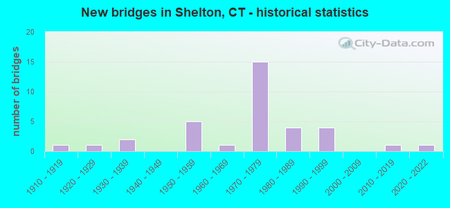
- New bridges - historical statistics
- 11910-1919
- 11920-1929
- 21930-1939
- 51950-1959
- 11960-1969
- 151970-1979
- 41980-1989
- 41990-1999
- 12010-2019
- 12020-2022

- Reconstructed bridges - Historical Statistics
- 11980-1989
- 11990-1999
- 02000-2009
- 12010-2019


- Bridge Condition - Deck
- 5.0%Very good
- 55.0%Good
- 40.0%Satisfactory

- Bridge Condition - Superstructure
- 4.3%Very good
- 30.4%Good
- 52.2%Satisfactory
- 13.0%Fair

- Bridge Condition - Substructure
- 4.3%Very good
- 30.4%Good
- 52.2%Satisfactory
- 13.0%Fair

- Bridge Condition - Channel
- 17.6%Good
- 58.8%Satisfactory
- 23.5%Fair

- Bridge Condition - Culverts
- 20.0%Very good
- 60.0%Satisfactory
- 20.0%Fair
Find on map >> Show street view
Structure Number: 57, Location: 300 FT S OF ROUTE 110 (Lat: 41.312078, Lng: -73.089908), Route carried "on" structure: City street , Year Built: 1950, Year Reconstructed: 1991, Status: Open, Structure Length: 3.08m (10.10ft), Average Daily Traffic: 5,801 (year 2021), Truck Traffic: 5%, Average Future Daily Traffic: 8,620 (year 2041), Design Load: HS 20, Features Intersected: ROUTE 8, Facility Carried by Structure: CORAM AVENUE
Minimum Vertical Clearance: 30+ m (98+ ft), Kilometerpoint: 1.014, Lanes on structure: 2, Lanes under structure: 5, Owner: State Highway Agency, Approaching Roadway Width: 11.9m (39.0ft), Material/Design: Steel, Design/Construction: Stringer/Multi-beam, Number Of Spans In Main Unit: 1, Length of Maximum Span: 29.3m (96.1ft), Curb or Sidewalk Widths: Left: 1.7m (5.6ft), Right: 1.7m (5.6ft), Curb-To-Curb Width: 11.9m (39.0ft), Out-to-Out Width: 16.1m (52.8ft)
Condition: Deck: Good, Superstructure: Satisfactory, Substructure: Satisfactory, Operating Rating: 73.1 metric tons, Method Used To Determine Operating Rating: Load Factor (LF), Inventory Rating: 43.9 metric tons, Method Used To Determine Inventory Rating: Load Factor (LF), Structural Evaluation: Equal to present minimum criteria, Deck Geometry: Somewhat better than minimum adequacy, Underclear: High priority of corrective action, Approach Roadway Alignment: Equal to present desirable criteria, Designated Inspection Frequency: Every 24 months, Inspection Date: November 2021, Deck Structure Type: Concrete Cast-file-Place, Wearing Surface/Protective System: Wearing Surface: Bituminous, Membrane: Preformed Fabric, Deck Protection: Epoxy Coated Reinforcing
Find on map >> Show street view
Structure Number: 571A, Location: ROUTE 8, EXIT 14 (Lat: 41.314025, Lng: -73.086975), Route carried "on" structure: State highway 8, Year Built: 1951, Year Reconstructed: 2019, Status: Open, Structure Length: 48.10m (157.81ft), Average Daily Traffic: 83,900 (year 2018), Truck Traffic: 6%, Average Future Daily Traffic: 124,667 (year 2038), Design Load: HS 20, Features Intersected: HOUSATONIC RIVER, RT 110
Minimum Vertical Clearance: 6.45m (21.16ft), Kilometerpoint: 19.763, Lanes on structure: 6, Lanes under structure: 7, Base Highway Network: Yes, Owner: State Highway Agency, Approaching Roadway Width: 26.8m (87.9ft), Skew: 30 degrees, Navigation Control: Yes ( Vertical Clearance: 10.4m (34.1ft), Horizontal Clearance: 30.5m (100.1ft)), Material/Design: Steel, Design/Construction: Truss - Deck, Number Of Spans In Main Unit: 3, Number Of Approach Spans: 9, Length of Maximum Span: 77.4m (253.9ft), Curb or Sidewalk Widths: Left: 1.5m (4.9ft), Right: 0.0m, Curb-To-Curb Width: 26.8m (87.9ft), Out-to-Out Width: 30.4m (99.7ft)
Condition: Deck: Satisfactory, Superstructure: Satisfactory, Substructure: Fair, Channel: Fair, Operating Rating: 42.4 metric tons, Method Used To Determine Operating Rating: Load and Resistance Factor Rating (LRFR) rating reported by rating factor(RF) method using HL-93 loadings, Inventory Rating: 32.7 metric tons, Method Used To Determine Inventory Rating: Load and Resistance Factor Rating (LRFR) rating reported by rating factor(RF) method using HL-93 loadings, Structural Evaluation: Somewhat better than minimum adequacy, Deck Geometry: Somewhat better than minimum adequacy, Underclear: High priority of corrective action, Waterway Adequacy: Superior to present desirable criteria, Approach Roadway Alignment: Equal to present desirable criteria, Designated Inspection Frequency: Every 24 months, Critical Feature Inspection Frequency: Every 24 months, Underwater Inspection Frequency: Every 24 months, Inspection Date: September 2021, Critical Feature Inspection Date: September 2021, Underwater Inspection Date: September 2021, Deck Structure Type: Concrete Cast-file-Place, Wearing Surface/Protective System: Wearing Surface: Bituminous, Membrane: Preformed Fabric, Deck Protection: Epoxy Coated Reinforcing
Find on map >> Show street view
Structure Number: 571B, Location: RT 8, EX 14 (JCT RT 110) (Lat: 41.312869, Lng: -73.087875), Route carried "on" structure: Ramp State highway 8, Year Built: 1990, Status: Open, Structure Length: 11.19m (36.71ft), Average Daily Traffic: 4,000 (year 2018), Truck Traffic: 6%, Average Future Daily Traffic: 5,944 (year 2038), Design Load: HS 20, Features Intersected: HULL AVE & PRIVATE DRIVE
Minimum Vertical Clearance: 30+ m (98+ ft), Kilometerpoint: 20.374, Lanes on structure: 1, Lanes under structure: 2, Owner: State Highway Agency, Approaching Roadway Width: 8.5m (27.9ft), Material/Design: Steel continuous, Design/Construction: Stringer/Multi-beam, Number Of Spans In Main Unit: 4, Length of Maximum Span: 31.4m (103.0ft), Curb-To-Curb Width: 8.5m (27.9ft), Out-to-Out Width: 9.7m (31.8ft)
Condition: Deck: Good, Superstructure: Satisfactory, Substructure: Satisfactory, Operating Rating: 58.0 metric tons, Method Used To Determine Operating Rating: Load and Resistance Factor Rating (LRFR) rating reported by rating factor(RF) method using HL-93 loadings, Inventory Rating: 44.7 metric tons, Method Used To Determine Inventory Rating: Load and Resistance Factor Rating (LRFR) rating reported by rating factor(RF) method using HL-93 loadings, Structural Evaluation: Equal to present minimum criteria, Deck Geometry: Superior to present desirable criteria, Underclear: Somewhat better than minimum adequacy, Approach Roadway Alignment: Meets minimum limits, Designated Inspection Frequency: Every 24 months, Inspection Date: September 2021, Deck Structure Type: Concrete Cast-file-Place, Wearing Surface/Protective System: Wearing Surface: Bituminous, Membrane: Preformed Fabric, Deck Protection: Epoxy Coated Reinforcing
Find on map >> Show street view
Structure Number: 571C, Location: RT 8,EXT 14 (JCT RTE 110) (Lat: 41.313364, Lng: -73.088103), Route carried "on" structure: Ramp State highway 8, Year Built: 1990, Status: Open, Structure Length: 16.09m (52.79ft), Average Daily Traffic: 9,000 (year 2018), Truck Traffic: 6%, Average Future Daily Traffic: 13,373 (year 2038), Design Load: HS 20, Features Intersected: HULL AVE & RIVERDALE AVE
Minimum Vertical Clearance: 30+ m (98+ ft), Kilometerpoint: 20.584, Lanes on structure: 2, Lanes under structure: 4, Owner: State Highway Agency, Approaching Roadway Width: 8.5m (27.9ft), Material/Design: Steel continuous, Design/Construction: Stringer/Multi-beam, Number Of Spans In Main Unit: 4, Length of Maximum Span: 57.6m (189.0ft), Curb or Sidewalk Widths: Left: 1.5m (4.9ft), Right: 0.0m, Curb-To-Curb Width: 8.5m (27.9ft), Out-to-Out Width: 11.5m (37.7ft)
Condition: Deck: Good, Superstructure: Satisfactory, Substructure: Satisfactory, Operating Rating: 30.5 metric tons, Method Used To Determine Operating Rating: Load and Resistance Factor Rating (LRFR) rating reported by rating factor(RF) method using HL-93 loadings, Inventory Rating: 23.3 metric tons, Method Used To Determine Inventory Rating: Load and Resistance Factor Rating (LRFR) rating reported by rating factor(RF) method using HL-93 loadings, Structural Evaluation: Somewhat better than minimum adequacy, Deck Geometry: High priority of corrective action, Underclear: High priority of corrective action, Approach Roadway Alignment: Equal to present minimum criteria, Designated Inspection Frequency: Every 24 months, Inspection Date: September 2021, Deck Structure Type: Concrete Cast-file-Place, Wearing Surface/Protective System: Wearing Surface: Bituminous, Membrane: Preformed Fabric, Deck Protection: Epoxy Coated Reinforcing
Find on map >> Show street view
Structure Number: 1306, Location: 3.4 MI N. OF ROUTE 15 (Lat: 41.283828, Lng: -73.155494), Route carried "on" structure: State highway 108, Year Built: 1932, Status: Open, Structure Length: 0.73m (2.40ft), Average Daily Traffic: 3,000 (year 2016), Truck Traffic: 3%, Average Future Daily Traffic: 4,458 (year 2036), Design Load: H 20, Features Intersected: FARMILL RIVER
Minimum Vertical Clearance: 30+ m (98+ ft), Kilometerpoint: 10.461, Lanes on structure: 2, Owner: State Highway Agency, Approaching Roadway Width: 6.1m (20.0ft), Skew: 2 degrees, Material/Design: Concrete, Design/Construction: Slab, Number Of Spans In Main Unit: 1, Length of Maximum Span: 6.1m (20.0ft), Curb-To-Curb Width: 6.1m (20.0ft), Out-to-Out Width: 7.0m (23.0ft)
Condition: Deck: Satisfactory, Superstructure: Fair, Substructure: Satisfactory, Channel: Satisfactory, Operating Rating: 53.5 metric tons, Method Used To Determine Operating Rating: Load Factor (LF), Inventory Rating: 32.1 metric tons, Method Used To Determine Inventory Rating: Load Factor (LF), Structural Evaluation: Somewhat better than minimum adequacy, Deck Geometry: High priority of replacement, Waterway Adequacy: Equal to present minimum criteria, Approach Roadway Alignment: Equal to present minimum criteria, Designated Inspection Frequency: Every 24 months, Inspection Date: June 2020, Deck Structure Type: Concrete Cast-file-Place, Wearing Surface/Protective System: Wearing Surface: Bituminous
Find on map >> Show street view
Structure Number: 1307, Location: 3.5 MI S OF ROUTE 110 (Lat: 41.296808, Lng: -73.146042), Route carried "on" structure: State highway 108, Year Built: 1925, Status: Open, Structure Length: 1.46m (4.79ft), Average Daily Traffic: 16,400 (year 2016), Truck Traffic: 3%, Average Future Daily Traffic: 24,369 (year 2036), Design Load: HS 20, Features Intersected: MEANS BROOK
Minimum Vertical Clearance: 30+ m (98+ ft), Kilometerpoint: 12.167, Lanes on structure: 2, Owner: State Highway Agency, Approaching Roadway Width: 8.5m (27.9ft), Skew: 4 degrees, Material/Design: Concrete, Design/Construction: Tee Beam, Number Of Spans In Main Unit: 1, Length of Maximum Span: 13.1m (43.0ft), Curb-To-Curb Width: 8.5m (27.9ft), Out-to-Out Width: 9.3m (30.5ft)
Condition: Deck: Satisfactory, Superstructure: Satisfactory, Substructure: Satisfactory, Channel: Satisfactory, Operating Rating: 36.6 metric tons, Method Used To Determine Operating Rating: Load and Resistance Factor Rating (LRFR) rating reported by rating factor(RF) method using HL-93 loadings, Inventory Rating: 28.2 metric tons, Method Used To Determine Inventory Rating: Load and Resistance Factor Rating (LRFR) rating reported by rating factor(RF) method using HL-93 loadings, Structural Evaluation: Equal to present minimum criteria, Deck Geometry: High priority of replacement, Waterway Adequacy: Equal to present minimum criteria, Approach Roadway Alignment: Better than present minimum criteria, Designated Inspection Frequency: Every 24 months, Inspection Date: June 2020, Deck Structure Type: Concrete Cast-file-Place, Wearing Surface/Protective System: Wearing Surface: Bituminous
Find on map >> Show street view
Structure Number: 1602, Location: 0.5 MILE N OF RT 110 (Lat: 41.338925, Lng: -73.124564), Route carried "on" structure: ServiceState highway 454, Year Built: 1910, Status: Open, Structure Length: 0.73m (2.40ft), Average Daily Traffic: 550 (year 2015), Truck Traffic: 2%, Average Future Daily Traffic: 817 (year 2035), Features Intersected: INDIAN HOLE BROOK
Minimum Vertical Clearance: 30+ m (98+ ft), Kilometerpoint: 0.724, Lanes on structure: 2, Owner: State Highway Agency, Approaching Roadway Width: 7.6m (24.9ft), Material/Design: Masonry, Design/Construction: Arch - Deck, Number Of Spans In Main Unit: 1, Length of Maximum Span: 7.3m (24.0ft), Curb-To-Curb Width: 7.2m (23.6ft), Out-to-Out Width: 9.1m (29.9ft)
Condition: Superstructure: Satisfactory, Substructure: Satisfactory, Channel: Satisfactory, Operating Rating: 89.8 metric tons, Method Used To Determine Operating Rating: Field evaluation and documented engineering judgment, Inventory Rating: 32.7 metric tons, Method Used To Determine Inventory Rating: Field evaluation and documented engineering judgment, Structural Evaluation: Equal to present minimum criteria, Deck Geometry: Meets minimum limits, Waterway Adequacy: Equal to present desirable criteria, Approach Roadway Alignment: Equal to present minimum criteria, Designated Inspection Frequency: Every 24 months, Inspection Date: July 2020, Total Project Cost: $2,400,000 ( Estimate for 2015)
Find on map >> Show street view
Structure Number: 1842, Location: AT THE MONROE NEWTOWN TL. (Lat: 41.388547, Lng: -73.188964), Route carried "on" structure: State highway 34, Year Built: 1963, Status: Open, Structure Length: 1.19m (3.90ft), Average Daily Traffic: 8,100 (year 2016), Truck Traffic: 4%, Average Future Daily Traffic: 12,036 (year 2036), Features Intersected: HALFWAY RIVER
Minimum Vertical Clearance: 30+ m (98+ ft), Kilometerpoint: 9.270, Lanes on structure: 2, Base Highway Network: Yes, Owner: State Highway Agency, Approaching Roadway Width: 12.5m (41.0ft), Skew: 4 degrees, Material/Design: Concrete continuous, Design/Construction: Frame, Number Of Spans In Main Unit: 2, Length of Maximum Span: 5.8m (19.0ft), Curb-To-Curb Width: 12.5m (41.0ft), Out-to-Out Width: 65.8m (215.9ft)
Condition: Superstructure: Satisfactory, Substructure: Satisfactory, Channel: Satisfactory, Structural Evaluation: Equal to present minimum criteria, Deck Geometry: Somewhat better than minimum adequacy, Waterway Adequacy: Superior to present desirable criteria, Approach Roadway Alignment: Equal to present desirable criteria, Designated Inspection Frequency: Every 24 months, Inspection Date: August 2021
Find on map >> Show street view
Structure Number: 272, Location: 2.5 MI N OF ROUTE 15 (Lat: 41.265706, Lng: -73.127019), Route carried "on" structure: State highway 8, Year Built: 1975, Status: Open, Structure Length: 3.38m (11.09ft), Average Daily Traffic: 32,550 (year 2018), Truck Traffic: 5%, Average Future Daily Traffic: 48,366 (year 2038), Design Load: HS 20, Features Intersected: ARMSTRONG ROAD
Minimum Vertical Clearance: 30+ m (98+ ft), Kilometerpoint: 13.486, Lanes on structure: 2, Lanes under structure: 2, Base Highway Network: Yes, Owner: State Highway Agency, Approaching Roadway Width: 13.7m (44.9ft), Skew: 13 degrees, Material/Design: Prestressed concrete, Design/Construction: Stringer/Multi-beam, Number Of Spans In Main Unit: 1, Length of Maximum Span: 32.0m (105.0ft), Curb or Sidewalk Widths: Left: 0.2m (0.7ft), Right: 0.2m (0.7ft), Curb-To-Curb Width: 13.7m (44.9ft), Out-to-Out Width: 14.8m (48.6ft)
Condition: Deck: Good, Superstructure: Satisfactory, Substructure: Satisfactory, Operating Rating: 66.7 metric tons, Method Used To Determine Operating Rating: Load Factor (LF), Inventory Rating: 39.9 metric tons, Method Used To Determine Inventory Rating: Load Factor (LF), Structural Evaluation: Equal to present minimum criteria, Deck Geometry: Superior to present desirable criteria, Underclear: Equal to present desirable criteria, Approach Roadway Alignment: Equal to present desirable criteria, Designated Inspection Frequency: Every 24 months, Inspection Date: March 2020, Deck Structure Type: Concrete Cast-file-Place, Wearing Surface/Protective System: Wearing Surface: Bituminous, Membrane: Built-up
Find on map >> Show street view
Structure Number: 2734, Location: 2.5 NORTH OF ROUTE 15 (Lat: 41.265617, Lng: -73.126508), Route carried "on" structure: State highway 8, Year Built: 1975, Status: Open, Structure Length: 3.38m (11.09ft), Average Daily Traffic: 32,550 (year 2018), Truck Traffic: 5%, Average Future Daily Traffic: 48,366 (year 2038), Design Load: HS 20, Features Intersected: ARMSTRONG ROAD
Minimum Vertical Clearance: 30+ m (98+ ft), Kilometerpoint: 13.502, Lanes on structure: 2, Lanes under structure: 2, Base Highway Network: Yes, Owner: State Highway Agency, Approaching Roadway Width: 12.2m (40.0ft), Skew: 12 degrees, Material/Design: Prestressed concrete, Design/Construction: Stringer/Multi-beam, Number Of Spans In Main Unit: 1, Length of Maximum Span: 32.0m (105.0ft), Curb or Sidewalk Widths: Left: 0.2m (0.7ft), Right: 0.2m (0.7ft), Curb-To-Curb Width: 12.2m (40.0ft), Out-to-Out Width: 13.3m (43.6ft)
Condition: Deck: Good, Superstructure: Good, Substructure: Good, Operating Rating: 45.7 metric tons, Method Used To Determine Operating Rating: Load and Resistance Factor Rating (LRFR) rating reported by rating factor(RF) method using HL-93 loadings, Inventory Rating: 34.0 metric tons, Method Used To Determine Inventory Rating: Load and Resistance Factor Rating (LRFR) rating reported by rating factor(RF) method using HL-93 loadings, Structural Evaluation: Better than present minimum criteria, Deck Geometry: Better than present minimum criteria, Underclear: Better than present minimum criteria, Approach Roadway Alignment: Equal to present desirable criteria, Designated Inspection Frequency: Every 24 months, Inspection Date: March 2020, Deck Structure Type: Concrete Cast-file-Place, Wearing Surface/Protective System: Wearing Surface: Bituminous, Membrane: Built-up
Find on map >> Show street view
Structure Number: 276, Location: 3.3 MI N OF ROUTE 15 (Lat: 41.274661, Lng: -73.117264), Route carried "on" structure: State highway 8, Year Built: 1975, Status: Open, Structure Length: 4.27m (14.01ft), Average Daily Traffic: 26,550 (year 2018), Truck Traffic: 5%, Average Future Daily Traffic: 39,451 (year 2038), Design Load: HS 20, Features Intersected: OLD STRATFORD ROAD
Minimum Vertical Clearance: 30+ m (98+ ft), Kilometerpoint: 14.774, Lanes on structure: 2, Lanes under structure: 6, Base Highway Network: Yes, Owner: State Highway Agency, Approaching Roadway Width: 12.2m (40.0ft), Skew: 10 degrees, Material/Design: Steel, Design/Construction: Stringer/Multi-beam, Number Of Spans In Main Unit: 1, Length of Maximum Span: 41.1m (134.8ft), Curb or Sidewalk Widths: Left: 0.2m (0.7ft), Right: 0.2m (0.7ft), Curb-To-Curb Width: 12.2m (40.0ft), Out-to-Out Width: 13.3m (43.6ft)
Condition: Deck: Good, Superstructure: Good, Substructure: Good, Operating Rating: 80.6 metric tons, Method Used To Determine Operating Rating: Load Factor (LF), Inventory Rating: 44.8 metric tons, Method Used To Determine Inventory Rating: Load Factor (LF), Structural Evaluation: Better than present minimum criteria, Deck Geometry: Better than present minimum criteria, Underclear: Meets minimum limits, Approach Roadway Alignment: Equal to present desirable criteria, Designated Inspection Frequency: Every 24 months, Inspection Date: September 2020, Deck Structure Type: Concrete Cast-file-Place, Wearing Surface/Protective System: Wearing Surface: Bituminous, Membrane: Built-up
Find on map >> Show street view
Structure Number: 2761, Location: 3.3 MI N OF ROUTE 15 (Lat: 41.274497, Lng: -73.116939), Route carried "on" structure: State highway 8, Year Built: 1975, Status: Open, Structure Length: 4.27m (14.01ft), Average Daily Traffic: 26,550 (year 2018), Truck Traffic: 5%, Average Future Daily Traffic: 39,451 (year 2038), Design Load: HS 20, Features Intersected: OLD STRATFORD ROAD
Minimum Vertical Clearance: 30+ m (98+ ft), Kilometerpoint: 14.774, Lanes on structure: 2, Lanes under structure: 6, Base Highway Network: Yes, Owner: State Highway Agency, Approaching Roadway Width: 12.2m (40.0ft), Skew: 10 degrees, Material/Design: Steel, Design/Construction: Stringer/Multi-beam, Number Of Spans In Main Unit: 1, Length of Maximum Span: 41.1m (134.8ft), Curb or Sidewalk Widths: Left: 0.2m (0.7ft), Right: 0.2m (0.7ft), Curb-To-Curb Width: 12.2m (40.0ft), Out-to-Out Width: 13.3m (43.6ft)
Condition: Deck: Good, Superstructure: Good, Substructure: Good, Inventory Rating: 63.0 metric tons, Method Used To Determine Inventory Rating: Load Factor (LF), Structural Evaluation: Better than present minimum criteria, Deck Geometry: Better than present minimum criteria, Underclear: Meets minimum limits, Approach Roadway Alignment: Equal to present desirable criteria, Designated Inspection Frequency: Every 24 months, Inspection Date: September 2020, Deck Structure Type: Concrete Cast-file-Place, Wearing Surface/Protective System: Wearing Surface: Bituminous, Membrane: Built-up
Find on map >> Show street view
Structure Number: 2787, Location: N OF ROUTE 8 EXIT 12 (Lat: 41.276386, Lng: -73.115003), Route carried "on" structure: State highway 8, Year Built: 1975, Status: Open, Structure Length: 8.38m (27.49ft), Average Daily Traffic: 26,550 (year 2018), Truck Traffic: 6%, Average Future Daily Traffic: 39,451 (year 2038), Design Load: HS 20, Features Intersected: FARMILL RV & BEARD SAWM
Minimum Vertical Clearance: 30+ m (98+ ft), Kilometerpoint: 15.015, Lanes on structure: 4, Lanes under structure: 2, Base Highway Network: Yes, Owner: State Highway Agency, Approaching Roadway Width: 17.7m (58.1ft), Skew: 11 degrees, Material/Design: Steel continuous, Design/Construction: Stringer/Multi-beam, Number Of Spans In Main Unit: 2, Length of Maximum Span: 41.1m (134.8ft), Curb or Sidewalk Widths: Left: 0.2m (0.7ft), Right: 0.2m (0.7ft), Curb-To-Curb Width: 17.9m (58.7ft), Out-to-Out Width: 18.9m (62.0ft)
Condition: Deck: Satisfactory, Superstructure: Satisfactory, Substructure: Satisfactory, Channel: Satisfactory, Operating Rating: 44.1 metric tons, Method Used To Determine Operating Rating: Load and Resistance Factor Rating (LRFR) rating reported by rating factor(RF) method using HL-93 loadings, Inventory Rating: 34.0 metric tons, Method Used To Determine Inventory Rating: Load and Resistance Factor Rating (LRFR) rating reported by rating factor(RF) method using HL-93 loadings, Structural Evaluation: Equal to present minimum criteria, Deck Geometry: Meets minimum limits, Underclear: Superior to present desirable criteria, Waterway Adequacy: Equal to present desirable criteria, Approach Roadway Alignment: Equal to present desirable criteria, Designated Inspection Frequency: Every 24 months, Inspection Date: May 2021, Deck Structure Type: Concrete Cast-file-Place, Wearing Surface/Protective System: Wearing Surface: Bituminous, Membrane: Built-up
Find on map >> Show street view
Structure Number: 2799, Location: N OF ROUTE 8 EXIT 12 (Lat: 41.276672, Lng: -73.115306), Route carried "on" structure: State highway 8, Year Built: 1975, Status: Open, Structure Length: 8.38m (27.49ft), Average Daily Traffic: 26,550 (year 2018), Truck Traffic: 6%, Average Future Daily Traffic: 39,451 (year 2038), Design Load: HS 20, Features Intersected: FARMILL RV & BEARD SAWM
Minimum Vertical Clearance: 30+ m (98+ ft), Kilometerpoint: 15.015, Lanes on structure: 3, Lanes under structure: 2, Base Highway Network: Yes, Owner: State Highway Agency, Approaching Roadway Width: 15.2m (49.9ft), Skew: 11 degrees, Material/Design: Steel continuous, Design/Construction: Stringer/Multi-beam, Number Of Spans In Main Unit: 2, Length of Maximum Span: 41.1m (134.8ft), Curb or Sidewalk Widths: Left: 0.2m (0.7ft), Right: 0.2m (0.7ft), Curb-To-Curb Width: 15.2m (49.9ft), Out-to-Out Width: 16.3m (53.5ft)
Condition: Deck: Good, Superstructure: Satisfactory, Substructure: Fair, Channel: Good, Operating Rating: 79.0 metric tons, Method Used To Determine Operating Rating: Load Factor (LF), Inventory Rating: 47.3 metric tons, Method Used To Determine Inventory Rating: Load Factor (LF), Structural Evaluation: Somewhat better than minimum adequacy, Deck Geometry: Meets minimum limits, Underclear: High priority of corrective action, Waterway Adequacy: Superior to present desirable criteria, Approach Roadway Alignment: Equal to present desirable criteria, Designated Inspection Frequency: Every 24 months, Inspection Date: May 2021, Deck Structure Type: Concrete Cast-file-Place, Wearing Surface/Protective System: Wearing Surface: Bituminous, Membrane: Built-up
Find on map >> Show street view
Structure Number: 2809, Location: .6 MI NORTH OF EXIT 12 (Lat: 41.284014, Lng: -73.111067), Route carried "on" structure: City street , Year Built: 1975, Status: Open, Structure Length: 6.98m (22.90ft), Average Daily Traffic: 5,096 (year 2020), Truck Traffic: 6%, Average Future Daily Traffic: 7,572 (year 2040), Design Load: HS 20, Features Intersected: ROUTE 8, Facility Carried by Structure: LONG HILL CROSS RD
Minimum Vertical Clearance: 30+ m (98+ ft), Kilometerpoint: 31.881, Lanes on structure: 2, Lanes under structure: 6, Owner: State Highway Agency, Approaching Roadway Width: 9.1m (29.9ft), Material/Design: Prestressed concrete continuous, Design/Construction: Box Beam or Girders - Single/Spread, Number Of Spans In Main Unit: 2, Length of Maximum Span: 34.7m (113.8ft), Curb or Sidewalk Widths: Left: 0.2m (0.7ft), Right: 1.7m (5.6ft), Curb-To-Curb Width: 9.1m (29.9ft), Out-to-Out Width: 11.7m (38.4ft)
Condition: Deck: Good, Superstructure: Satisfactory, Substructure: Satisfactory, Operating Rating: 70.6 metric tons, Method Used To Determine Operating Rating: Load and Resistance Factor Rating (LRFR) rating reported by rating factor(RF) method using HL-93 loadings, Inventory Rating: 54.4 metric tons, Method Used To Determine Inventory Rating: Load and Resistance Factor Rating (LRFR) rating reported by rating factor(RF) method using HL-93 loadings, Structural Evaluation: Equal to present minimum criteria, Deck Geometry: Meets minimum limits, Underclear: Meets minimum limits, Approach Roadway Alignment: Better than present minimum criteria, Designated Inspection Frequency: Every 24 months, Inspection Date: March 2020, Deck Structure Type: Concrete Cast-file-Place, Wearing Surface/Protective System: Wearing Surface: Bituminous, Membrane: Built-up
Find on map >> Show street view
Structure Number: 2815, Location: 1.5 MI SOUTH OF ROUTE 110 (Lat: 41.294394, Lng: -73.105653), Route carried "on" structure: City street , Year Built: 1975, Status: Open, Structure Length: 7.99m (26.21ft), Average Daily Traffic: 5,628 (year 2018), Truck Traffic: 5%, Average Future Daily Traffic: 8,363 (year 2038), Design Load: HS 20, Features Intersected: ROUTE 8, Facility Carried by Structure: PLATT ROAD
Minimum Vertical Clearance: 30+ m (98+ ft), Kilometerpoint: 0.274, Lanes on structure: 2, Lanes under structure: 6, Owner: State Highway Agency, Approaching Roadway Width: 9.1m (29.9ft), Material/Design: Prestressed concrete continuous, Design/Construction: Box Beam or Girders - Multiple, Number Of Spans In Main Unit: 2, Length of Maximum Span: 39.6m (129.9ft), Curb or Sidewalk Widths: Left: 0.2m (0.7ft), Right: 1.7m (5.6ft), Curb-To-Curb Width: 9.1m (29.9ft), Out-to-Out Width: 11.7m (38.4ft)
Condition: Deck: Satisfactory, Superstructure: Fair, Substructure: Good, Inventory Rating: 50.4 metric tons, Method Used To Determine Inventory Rating: Load Factor (LF), Structural Evaluation: Somewhat better than minimum adequacy, Deck Geometry: Meets minimum limits, Underclear: Equal to present minimum criteria, Approach Roadway Alignment: Equal to present minimum criteria, Designated Inspection Frequency: Every 24 months, Inspection Date: March 2020, Deck Structure Type: Concrete Cast-file-Place, Wearing Surface/Protective System: Wearing Surface: Bituminous, Membrane: Built-up
Find on map >> Show street view
Structure Number: 2831, Location: .1 MI N OF EXT 13 RTE 8 S (Lat: 41.304517, Lng: -73.099544), Route carried "on" structure: City street , Year Built: 1975, Status: Open, Structure Length: 5.52m (18.11ft), Average Daily Traffic: 14,805 (year 2021), Truck Traffic: 5%, Average Future Daily Traffic: 21,999 (year 2041), Design Load: HS 20, Features Intersected: ROUTE 8, Facility Carried by Structure: CONSTITUTION BLVD
Minimum Vertical Clearance: 30+ m (98+ ft), Kilometerpoint: 0.274, Lanes on structure: 4, Lanes under structure: 5, Owner: State Highway Agency, Approaching Roadway Width: 13.4m (44.0ft), Material/Design: Steel, Design/Construction: Box Beam or Girders - Single/Spread, Number Of Spans In Main Unit: 1, Length of Maximum Span: 53.3m (174.9ft), Curb or Sidewalk Widths: Left: 0.0m, Right: 1.7m (5.6ft), Curb-To-Curb Width: 13.4m (44.0ft), Out-to-Out Width: 16.3m (53.5ft)
Condition: Deck: Satisfactory, Superstructure: Good, Substructure: Good, Operating Rating: 78.7 metric tons, Method Used To Determine Operating Rating: Load and Resistance Factor Rating (LRFR) rating reported by rating factor(RF) method using HL-93 loadings, Inventory Rating: 60.6 metric tons, Method Used To Determine Inventory Rating: Load and Resistance Factor Rating (LRFR) rating reported by rating factor(RF) method using HL-93 loadings, Structural Evaluation: Better than present minimum criteria, Deck Geometry: High priority of replacement, Underclear: Equal to present minimum criteria, Approach Roadway Alignment: Somewhat better than minimum adequacy, Designated Inspection Frequency: Every 24 months, Inspection Date: May 2021, Deck Structure Type: Concrete Cast-file-Place, Wearing Surface/Protective System: Wearing Surface: Bituminous, Membrane: Built-up
Find on map >> Show street view
Structure Number: 2921, Location: 50' EAST FROM ROUTE 110 (Lat: 41.318061, Lng: -73.092725), Route carried "on" structure: State highway 712, Year Built: 1973, Status: Open, Structure Length: 7.59m (24.90ft), Average Daily Traffic: 12,800 (year 2016), Truck Traffic: 3%, Average Future Daily Traffic: 19,020 (year 2036), Design Load: HL 93, Features Intersected: HOUSATONIC RR & LOCAL RD
Minimum Vertical Clearance: 30+ m (98+ ft), Kilometerpoint: 0.016, Lanes on structure: 2, Lanes under structure: 4, Owner: State Highway Agency, Approaching Roadway Width: 10.7m (35.1ft), Material/Design: Prestressed concrete, Design/Construction: Box Beam or Girders - Multiple, Number Of Spans In Main Unit: 4, Length of Maximum Span: 19.2m (63.0ft), Curb or Sidewalk Widths: Left: 0.0m, Right: 1.7m (5.6ft), Curb-To-Curb Width: 10.7m (35.1ft), Out-to-Out Width: 13.3m (43.6ft)
Condition: Deck: Satisfactory, Superstructure: Fair, Substructure: Fair, Operating Rating: 48.0 metric tons, Method Used To Determine Operating Rating: Load and Resistance Factor Rating (LRFR) rating reported by rating factor(RF) method using HL-93 loadings, Inventory Rating: 36.0 metric tons, Method Used To Determine Inventory Rating: Load and Resistance Factor Rating (LRFR) rating reported by rating factor(RF) method using HL-93 loadings, Structural Evaluation: Somewhat better than minimum adequacy, Deck Geometry: Meets minimum limits, Underclear: High priority of corrective action, Approach Roadway Alignment: Equal to present minimum criteria, Designated Inspection Frequency: Every 24 months, Inspection Date: Febuary 2020, Deck Structure Type: Other, Wearing Surface/Protective System: Wearing Surface: Bituminous, Membrane: Built-up
Find on map >> Show street view
Structure Number: 4159, Location: 0.5 MI S OF RPUTE 108 (Lat: 41.288442, Lng: -73.140875), Route carried "on" structure: City street , Year Built: 1934, Year Reconstructed: 1990, Status: Open, Structure Length: 0.85m (2.79ft), Average Daily Traffic: 14,974 (year 2010), Truck Traffic: 4%, Average Future Daily Traffic: 22,250 (year 2030), Design Load: HS 20, Features Intersected: FARMILL RIVER, Facility Carried by Structure: HUNTINGTON STREET
Minimum Vertical Clearance: 30+ m (98+ ft), Kilometerpoint: 3.879, Lanes on structure: 2, Owner: City or Municipal Highway Agency, Approaching Roadway Width: 7.6m (24.9ft), Material/Design: Prestressed concrete, Design/Construction: Slab, Number Of Spans In Main Unit: 1, Length of Maximum Span: 7.9m (25.9ft), Curb or Sidewalk Widths: Left: 0.0m, Right: 1.7m (5.6ft), Curb-To-Curb Width: 8.5m (27.9ft), Out-to-Out Width: 11.2m (36.7ft)
Condition: Deck: Good, Superstructure: Good, Substructure: Satisfactory, Channel: Fair, Operating Rating: 35.3 metric tons, Method Used To Determine Operating Rating: Load and Resistance Factor Rating (LRFR) rating reported by rating factor(RF) method using HL-93 loadings, Inventory Rating: 27.2 metric tons, Method Used To Determine Inventory Rating: Load and Resistance Factor Rating (LRFR) rating reported by rating factor(RF) method using HL-93 loadings, Structural Evaluation: Equal to present minimum criteria, Deck Geometry: High priority of replacement, Waterway Adequacy: Equal to present desirable criteria, Approach Roadway Alignment: Equal to present desirable criteria, Designated Inspection Frequency: Every 24 months, Inspection Date: July 2020, Deck Structure Type: Other, Wearing Surface/Protective System: Wearing Surface: Bituminous, Membrane: Built-up, Deck Protection: Epoxy Coated Reinforcing
Find on map >> Show street view
Structure Number: 4927, Location: 1.1 MI WEST OF ROUTE 108 (Lat: 41.313242, Lng: -73.154294), Route carried "on" structure: City street , Year Built: 1978, Status: Open, Structure Length: 0.88m (2.89ft), Average Daily Traffic: 700 (year 2014), Truck Traffic: 2%, Average Future Daily Traffic: 1,040 (year 2034), Features Intersected: MEANS BROOK, Facility Carried by Structure: CHAMBERLAIN DRIVE
Minimum Vertical Clearance: 30+ m (98+ ft), Kilometerpoint: 0.612, Lanes on structure: 2, Owner: City or Municipal Highway Agency, Approaching Roadway Width: 9.1m (29.9ft), Material/Design: Steel, Design/Construction: Culvert, Number Of Spans In Main Unit: 2, Length of Maximum Span: 3.7m (12.1ft), Curb or Sidewalk Widths: Left: 1.1m (3.6ft), Right: 1.3m (4.3ft), Curb-To-Curb Width: 9.1m (29.9ft), Out-to-Out Width: 12.4m (40.7ft)
Condition: Channel: Satisfactory, Culverts: Fair, Operating Rating: 97.2 metric tons, Method Used To Determine Operating Rating: Load and Resistance Factor Rating (LRFR) rating reported by rating factor(RF) method using HL-93 loadings, Inventory Rating: 96.6 metric tons, Method Used To Determine Inventory Rating: Load and Resistance Factor Rating (LRFR) rating reported by rating factor(RF) method using HL-93 loadings, Structural Evaluation: Somewhat better than minimum adequacy, Deck Geometry: Equal to present minimum criteria, Waterway Adequacy: Better than present minimum criteria, Approach Roadway Alignment: Better than present minimum criteria, Designated Inspection Frequency: Every 24 months, Inspection Date: July 2020
Find on map >> Show street view
Structure Number: 5277, Location: 0.5 MI N OF ROUTE 108 (Lat: 41.288667, Lng: -73.156736), Route carried "on" structure: City street , Year Built: 2019, Status: Open, Structure Length: 1.19m (3.90ft), Average Daily Traffic: 3,270 (year 2011), Truck Traffic: 4%, Average Future Daily Traffic: 4,859 (year 2031), Design Load: HL 93, Features Intersected: FARMILL RIVER, Facility Carried by Structure: WAVERLY ROAD
Minimum Vertical Clearance: 30+ m (98+ ft), Kilometerpoint: 4.538, Lanes on structure: 2, Owner: City or Municipal Highway Agency, Approaching Roadway Width: 7.3m (24.0ft), Material/Design: Concrete, Design/Construction: Culvert, Number Of Spans In Main Unit: 3, Length of Maximum Span: 3.4m (11.2ft), Curb-To-Curb Width: 8.5m (27.9ft), Out-to-Out Width: 9.6m (31.5ft)
Condition: Channel: Good, Culverts: Very good, Inventory Rating: 46.7 metric tons, Method Used To Determine Inventory Rating: Load and Resistance Factor Rating (LRFR) rating reported by rating factor(RF) method using HL-93 loadings, Structural Evaluation: Equal to present desirable criteria, Deck Geometry: Meets minimum limits, Waterway Adequacy: Better than present minimum criteria, Approach Roadway Alignment: Equal to present minimum criteria, Designated Inspection Frequency: Every 24 months, Inspection Date: July 2020, Wearing Surface/Protective System: Wearing Surface: Bituminous
Find on map >> Show street view
Structure Number: 5278, Location: 0.3 MI N OF WAVERLY ROAD (Lat: 41.291039, Lng: -73.175000), Route carried "on" structure: City street , Year Built: 1996, Status: Open, Structure Length: 1.04m (3.41ft), Average Daily Traffic: 960 (year 2020), Truck Traffic: 2%, Average Future Daily Traffic: 1,426 (year 2040), Features Intersected: FARMILL RIVER, Facility Carried by Structure: FARMILL STREET
Minimum Vertical Clearance: 30+ m (98+ ft), Kilometerpoint: 0.402, Lanes on structure: 2, Owner: City or Municipal Highway Agency, Approaching Roadway Width: 6.7m (22.0ft), Skew: 3 degrees, Material/Design: Concrete, Design/Construction: Culvert, Number Of Spans In Main Unit: 2, Length of Maximum Span: 4.9m (16.1ft), Curb or Sidewalk Widths: Left: 0.3m (1.0ft), Right: 0.3m (1.0ft), Curb-To-Curb Width: 9.2m (30.2ft), Out-to-Out Width: 14.9m (48.9ft)
Condition: Channel: Satisfactory, Culverts: Satisfactory, Operating Rating: 42.6 metric tons, Method Used To Determine Operating Rating: Field evaluation and documented engineering judgment, Inventory Rating: 32.7 metric tons, Method Used To Determine Inventory Rating: Field evaluation and documented engineering judgment, Structural Evaluation: Equal to present minimum criteria, Deck Geometry: Equal to present minimum criteria, Waterway Adequacy: Better than present minimum criteria, Approach Roadway Alignment: Equal to present minimum criteria, Designated Inspection Frequency: Every 24 months, Inspection Date: September 2020, Deck Structure Type: Other, Wearing Surface/Protective System: Wearing Surface: Bituminous
Find on map >> Show street view
Structure Number: 5279, Location: 0.1 MI E OF RTE 8 EXIT 12 (Lat: 41.274342, Lng: -73.114322), Route carried "on" structure: City street , Year Built: 1982, Status: Open, Structure Length: 12.19m (39.99ft), Average Daily Traffic: 1,158 (year 2020), Truck Traffic: 4%, Average Future Daily Traffic: 1,721 (year 2040), Design Load: HS 20, Features Intersected: FARMILL RIVER, Facility Carried by Structure: FARMILL CROSSING
Minimum Vertical Clearance: 30+ m (98+ ft), Kilometerpoint: 0.048, Lanes on structure: 2, Owner: City or Municipal Highway Agency, Approaching Roadway Width: 9.8m (32.2ft), Material/Design: Steel, Design/Construction: Stringer/Multi-beam, Number Of Spans In Main Unit: 4, Length of Maximum Span: 31.7m (104.0ft), Curb or Sidewalk Widths: Left: 1.2m (3.9ft), Right: 0.0m, Curb-To-Curb Width: 9.8m (32.2ft), Out-to-Out Width: 11.9m (39.0ft)
Condition: Deck: Satisfactory, Superstructure: Satisfactory, Substructure: Good, Channel: Satisfactory, Operating Rating: 60.3 metric tons, Method Used To Determine Operating Rating: Load and Resistance Factor Rating (LRFR) rating reported by rating factor(RF) method using HL-93 loadings, Inventory Rating: 46.3 metric tons, Method Used To Determine Inventory Rating: Load and Resistance Factor Rating (LRFR) rating reported by rating factor(RF) method using HL-93 loadings, Structural Evaluation: Equal to present minimum criteria, Deck Geometry: Somewhat better than minimum adequacy, Waterway Adequacy: Equal to present desirable criteria, Approach Roadway Alignment: Better than present minimum criteria, Designated Inspection Frequency: Every 24 months, Inspection Date: August 2020, Deck Structure Type: Concrete Cast-file-Place, Wearing Surface/Protective System: Wearing Surface: Bituminous, Deck Protection: Epoxy Coated Reinforcing
Find on map >> Show street view
Structure Number: 528, Location: 0.1 MI E OF ROUTE 108 (Lat: 41.296997, Lng: -73.144392), Route carried "on" structure: City street , Year Built: 1982, Status: Open, Structure Length: 0.64m (2.10ft), Average Daily Traffic: 660 (year 2014), Truck Traffic: 2%, Average Future Daily Traffic: 981 (year 2034), Features Intersected: BROOK, Facility Carried by Structure: OLD SHELTON ROAD
Minimum Vertical Clearance: 30+ m (98+ ft), Kilometerpoint: 0.064, Lanes on structure: 2, Owner: City or Municipal Highway Agency, Approaching Roadway Width: 6.7m (22.0ft), Material/Design: Concrete, Design/Construction: Culvert, Number Of Spans In Main Unit: 2, Length of Maximum Span: 3.0m (9.8ft)
Condition: Channel: Fair, Culverts: Satisfactory, Operating Rating: 42.6 metric tons, Method Used To Determine Operating Rating: Field evaluation and documented engineering judgment, Inventory Rating: 32.7 metric tons, Method Used To Determine Inventory Rating: Field evaluation and documented engineering judgment, Structural Evaluation: Equal to present minimum criteria, Waterway Adequacy: Meets minimum limits, Approach Roadway Alignment: Equal to present desirable criteria, Designated Inspection Frequency: Every 24 months, Inspection Date: July 2020
Find on map >> Show street view
Structure Number: 5313, Location: 0.1 MI E OF HUNTINGTON RD (Lat: 41.282733, Lng: -73.137236), Route carried "on" structure: City street , Year Built: 1981, Status: Open, Structure Length: 1.95m (6.40ft), Average Daily Traffic: 1,100 (year 2010), Truck Traffic: 2%, Average Future Daily Traffic: 1,634 (year 2030), Features Intersected: FARMILL RIVER, Facility Carried by Structure: BUDDINGTON ROAD
Minimum Vertical Clearance: 30+ m (98+ ft), Kilometerpoint: 0.097, Lanes on structure: 2, Owner: City or Municipal Highway Agency, Approaching Roadway Width: 8.5m (27.9ft), Material/Design: Concrete, Design/Construction: Arch - Deck, Number Of Spans In Main Unit: 2, Length of Maximum Span: 9.1m (29.9ft), Curb or Sidewalk Widths: Left: 0.0m, Right: 1.6m (5.2ft), Curb-To-Curb Width: 8.5m (27.9ft), Out-to-Out Width: 11.0m (36.1ft)
Condition: Superstructure: Good, Substructure: Satisfactory, Channel: Fair, Operating Rating: 42.6 metric tons, Method Used To Determine Operating Rating: Field evaluation and documented engineering judgment, Inventory Rating: 32.7 metric tons, Method Used To Determine Inventory Rating: Field evaluation and documented engineering judgment, Structural Evaluation: Equal to present minimum criteria, Deck Geometry: Somewhat better than minimum adequacy, Waterway Adequacy: Better than present minimum criteria, Approach Roadway Alignment: Equal to present minimum criteria, Designated Inspection Frequency: Every 24 months, Inspection Date: September 2020
Find on map >> Show street view
Structure Number: 5949, Location: 0.1 MI E OF HUNTINGTON RD (Lat: 41.292928, Lng: -73.144069), Route carried "on" structure: City street , Year Built: 2020, Status: Open, Structure Length: 1.37m (4.49ft), Average Daily Traffic: 120 (year 2020), Truck Traffic: 2%, Average Future Daily Traffic: 178 (year 2040), Design Load: H 20, Features Intersected: MEANS BROOK, Facility Carried by Structure: LANE STREET
Minimum Vertical Clearance: 30+ m (98+ ft), Kilometerpoint: 0.209, Lanes on structure: 2, Owner: City or Municipal Highway Agency, Approaching Roadway Width: 7.3m (24.0ft), Skew: 1 degrees, Material/Design: Prestressed concrete, Design/Construction: Slab, Number Of Spans In Main Unit: 1, Length of Maximum Span: 12.6m (41.3ft), Curb or Sidewalk Widths: Left: 1.5m (4.9ft), Right: 0.0m, Curb-To-Curb Width: 7.4m (24.3ft), Out-to-Out Width: 9.9m (32.5ft)
Condition: Deck: Very good, Superstructure: Very good, Substructure: Very good, Channel: Good, Operating Rating: 54.6 metric tons, Method Used To Determine Operating Rating: Load Factor (LF), Inventory Rating: 32.7 metric tons, Method Used To Determine Inventory Rating: Load Factor (LF), Structural Evaluation: Equal to present desirable criteria, Deck Geometry: Somewhat better than minimum adequacy, Waterway Adequacy: Somewhat better than minimum adequacy, Approach Roadway Alignment: Equal to present desirable criteria, Designated Inspection Frequency: Every 24 months, Inspection Date: July 2020, Total Project Cost: $1,700,000 ( Estimate for 2014), Wearing Surface/Protective System: Wearing Surface: Bituminous, Membrane: Built-up, Deck Protection: Epoxy Coated Reinforcing
Find on map >> Show street view
Structure Number: 6138, Location: 1 MI WEST OF ROUTE 108 (Lat: 41.292847, Lng: -73.173353), Route carried "on" structure: City street , Year Built: 1983, Status: Open, Structure Length: 0.64m (2.10ft), Average Daily Traffic: 105 (year 2014), Truck Traffic: 2%, Average Future Daily Traffic: 156 (year 2034), Features Intersected: FARMILL RIVER, Facility Carried by Structure: CORN HILL ROAD
Minimum Vertical Clearance: 30+ m (98+ ft), Kilometerpoint: 0.129, Lanes on structure: 2, Owner: City or Municipal Highway Agency, Approaching Roadway Width: 9.1m (29.9ft), Material/Design: Concrete, Design/Construction: Culvert, Number Of Spans In Main Unit: 2, Length of Maximum Span: 3.0m (9.8ft)
Condition: Channel: Satisfactory, Culverts: Satisfactory, Operating Rating: 42.6 metric tons, Method Used To Determine Operating Rating: Field evaluation and documented engineering judgment, Inventory Rating: 32.7 metric tons, Method Used To Determine Inventory Rating: Field evaluation and documented engineering judgment, Structural Evaluation: Equal to present minimum criteria, Waterway Adequacy: Equal to present desirable criteria, Approach Roadway Alignment: Equal to present desirable criteria, Designated Inspection Frequency: Every 24 months, Inspection Date: July 2020
Find on map >> Show street view
Structure Number: 6215, Location: 2.0 MI N OF ROUTE 108 (Lat: 41.277739, Lng: -73.121186), Route carried "on" structure: State highway 714, Year Built: 1993, Status: Open, Structure Length: 1.80m (5.91ft), Average Daily Traffic: 17,400 (year 2016), Truck Traffic: 3%, Average Future Daily Traffic: 25,855 (year 2036), Design Load: HS 20, Features Intersected: FARMILL RIVER
Minimum Vertical Clearance: 30+ m (98+ ft), Kilometerpoint: 3.170, Lanes on structure: 5, Owner: State Highway Agency, Approaching Roadway Width: 13.1m (43.0ft), Skew: 1 degrees, Material/Design: Prestressed concrete, Design/Construction: Box Beam or Girders - Multiple, Number Of Spans In Main Unit: 1, Length of Maximum Span: 17.1m (56.1ft), Curb-To-Curb Width: 22.1m (72.5ft), Out-to-Out Width: 23.4m (76.8ft)
Condition: Deck: Good, Superstructure: Good, Substructure: Good, Channel: Satisfactory, Operating Rating: 33.0 metric tons, Method Used To Determine Operating Rating: Load and Resistance Factor Rating (LRFR) rating reported by rating factor(RF) method using HL-93 loadings, Inventory Rating: 25.3 metric tons, Method Used To Determine Inventory Rating: Load and Resistance Factor Rating (LRFR) rating reported by rating factor(RF) method using HL-93 loadings, Structural Evaluation: Equal to present minimum criteria, Deck Geometry: Somewhat better than minimum adequacy, Waterway Adequacy: Equal to present minimum criteria, Approach Roadway Alignment: Equal to present desirable criteria, Designated Inspection Frequency: Every 24 months, Inspection Date: July 2021, Deck Structure Type: Other, Wearing Surface/Protective System: Wearing Surface: Bituminous, Membrane: Built-up, Deck Protection: Epoxy Coated Reinforcing
Find on map >> Show street view
Structure Number: 569, Location: 0.1 MI S OF ROUTE 110 (Lat: 41.311628, Lng: -73.090953), Route carried "under" structure: State highway 8, Year Built: 1950, Structure Length: 0. m, Average Daily Traffic: 64,400 (year 2018), Truck Traffic: 6%, Features Intersected: ROUTE 8, Facility Carried by Structure: PROSPECT AVENUE
Minimum Vertical Clearance: 4.65m (15.26ft), Kilometerpoint: 19.570, Lanes on structure: 2, Lanes under structure: 4, Material/Design: Steel, Design/Construction: Stringer/Multi-beam, Length of Maximum Span: 25.6m (84.0ft)
Find on map >> Show street view
Structure Number: 57, Location: 300 FT S OF ROUTE 110 (Lat: 41.312078, Lng: -73.089908), Route carried "under" structure: State highway 8, Year Built: 1950, Structure Length: 0. m, Average Daily Traffic: 66,000 (year 2018), Truck Traffic: 6%, Features Intersected: ROUTE 8, Facility Carried by Structure: CORAM AVENUE
Minimum Vertical Clearance: 4.88m (16.01ft), Kilometerpoint: 19.666, Lanes on structure: 2, Lanes under structure: 5, Material/Design: Steel, Design/Construction: Stringer/Multi-beam, Length of Maximum Span: 29.3m (96.1ft)
Find on map >> Show street view
Structure Number: 571A, Location: ROUTE 8, EXIT 14 (Lat: 41.314025, Lng: -73.086975), Route carried "under" structure: State highway 110, Year Built: 1951, Structure Length: 0. m, Average Daily Traffic: 9,800 (year 2020), Truck Traffic: 6%, Features Intersected: HOUSATONIC RIVER, RT 110, Facility Carried by Structure: ROUTE 8
Minimum Vertical Clearance: 4.62m (15.16ft), Kilometerpoint: 14.162, Lanes on structure: 6, Lanes under structure: 3, Material/Design: Steel, Design/Construction: Truss - Deck, Length of Maximum Span: 77.4m (253.9ft)
Find on map >> Show street view
Structure Number: 2809, Location: .6 MI NORTH OF EXIT 12 (Lat: 41.284014, Lng: -73.111067), Route carried "under" structure: State highway 8, Year Built: 1975, Structure Length: 0. m, Average Daily Traffic: 65,100 (year 2018), Truck Traffic: 9%, Features Intersected: ROUTE 8, Facility Carried by Structure: LONG HILL CROSS RD
Minimum Vertical Clearance: 6.66m (21.85ft), Kilometerpoint: 15.933, Lanes on structure: 2, Lanes under structure: 6, Material/Design: Prestressed concrete continuous, Design/Construction: Box Beam or Girders - Single/Spread, Length of Maximum Span: 34.7m (113.8ft)
Find on map >> Show street view
Structure Number: 2815, Location: 1.5 MI SOUTH OF ROUTE 110 (Lat: 41.294394, Lng: -73.105653), Route carried "under" structure: State highway 8, Year Built: 1975, Structure Length: 0. m, Average Daily Traffic: 65,100 (year 2018), Truck Traffic: 6%, Features Intersected: ROUTE 8, Facility Carried by Structure: PLATT ROAD
Minimum Vertical Clearance: 6.81m (22.34ft), Kilometerpoint: 17.188, Lanes on structure: 2, Lanes under structure: 6, Material/Design: Prestressed concrete continuous, Design/Construction: Box Beam or Girders - Multiple, Length of Maximum Span: 39.6m (129.9ft)
Find on map >> Show street view
Structure Number: 2831, Location: .1 MI N OF EXT 13 RTE 8 S (Lat: 41.304517, Lng: -73.099544), Route carried "under" structure: State highway 8, Year Built: 1975, Structure Length: 0. m, Average Daily Traffic: 60,200 (year 2018), Truck Traffic: 6%, Features Intersected: ROUTE 8, Facility Carried by Structure: CONSTITUTION BLVD
Minimum Vertical Clearance: 5.77m (18.93ft), Kilometerpoint: 18.427, Lanes on structure: 4, Lanes under structure: 5, Material/Design: Steel, Design/Construction: Box Beam or Girders - Single/Spread, Length of Maximum Span: 53.3m (174.9ft)
Find on map >> Show street view
Structure Number: 2936, Location: 1.3 MI N OF ROUTE 15 (Lat: 41.255572, Lng: -73.145947), Route carried "under" structure: Interstate 8, Year Built: 1975, Structure Length: 0. m, Average Daily Traffic: 60,300 (year 2018), Truck Traffic: 8%, Features Intersected: ROUTE 8, Facility Carried by Structure: HUNTINGTON ROAD
Minimum Vertical Clearance: 5.26m (17.26ft), Kilometerpoint: 11.523, Lanes on structure: 4, Lanes under structure: 4, Material/Design: Steel continuous, Design/Construction: Stringer/Multi-beam, Length of Maximum Span: 45.1m (148.0ft)