Bridge Statistics for Shelby, Michigan (MI)
Condition, Traffic, Stress, Structural Evaluation, Project Costs
- National Bridge Inventory (NBI) Statistics
- 29Number of bridges
- 174ft / 53.2mTotal length
- $405,000Total costs
- 662,870Total average daily traffic
- 25,933Total average daily truck traffic
- National Bridge Inventory (NBI) Registered Bridges for Shelby
- No street view available for this location
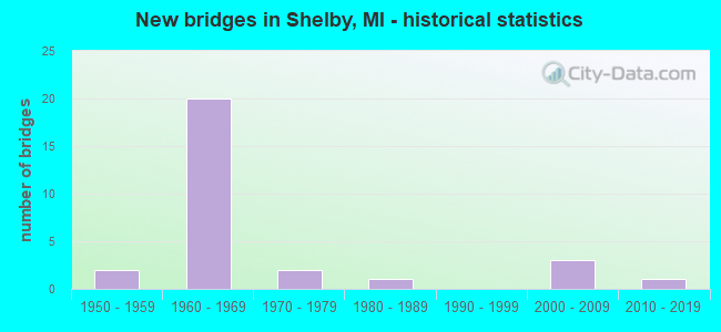
- New bridges - historical statistics
- 21950-1959
- 201960-1969
- 21970-1979
- 11980-1989
- 32000-2009
- 12010-2019

- Reconstructed bridges - Historical Statistics
- 21990-1999
- 12000-2009


- Bridge Condition - Deck
- 7.1%Excellent
- 7.1%Very good
- 57.1%Good
- 21.4%Satisfactory
- 7.1%Fair

- Bridge Condition - Superstructure
- 14.3%Very good
- 42.9%Good
- 28.6%Satisfactory
- 14.3%Fair

- Bridge Condition - Substructure
- 14.3%Very good
- 78.6%Good
- 7.1%Satisfactory

- Bridge Condition - Channel
- 38.5%Good
- 30.8%Satisfactory
- 23.1%Fair
- 7.7%Poor

- Bridge Condition - Culverts
- 16.7%Very good
- 16.7%Good
- 33.3%Satisfactory
- 16.7%Fair
- 16.7%Serious
Find on map >> Show street view
Structure Number: 6024, Location: 5.6 MI N OF M-59 (Lat: 42.705889, Lng: -83.026058), Route carried "on" structure: State highway 53, Year Built: 1966, Year Reconstructed: 2001, Status: Open, Structure Length: 3.18m (10.43ft), Average Daily Traffic: 29,646 (year 2015), Truck Traffic: 4%, Average Future Daily Traffic: 34,093 (year 2035), Design Load: HS 25 or greater, Features Intersected: MIDDLE BR CLINTON RIVER
Minimum Vertical Clearance: 30.48m (100.00ft), Kilometerpoint: 18.344, Lanes on structure: 2, Base Highway Network: Yes (Inventory Route: 81, Subroute: 6), Owner: State Highway Agency, Approaching Roadway Width: 13.5m (44.3ft), Skew: 2 degrees, Material/Design: Prestressed concrete, Design/Construction: Stringer/Multi-beam, Number Of Spans In Main Unit: 3, Length of Maximum Span: 11.2m (36.7ft), Curb-To-Curb Width: 12.9m (42.3ft), Out-to-Out Width: 13.9m (45.6ft)
Condition: Deck: Very good, Superstructure: Very good, Substructure: Good, Channel: Fair, Operating Rating: 56.7 metric tons, Method Used To Determine Operating Rating: Load Factor (LF) rating reported by rating factor (RF) method using MS18 loading, Inventory Rating: 29.8 metric tons, Method Used To Determine Inventory Rating: Load Factor (LF) rating reported by rating factor (RF) method using MS18 loading, Structural Evaluation: Better than present minimum criteria, Deck Geometry: Superior to present desirable criteria, Waterway Adequacy: Better than present minimum criteria, Approach Roadway Alignment: Equal to present desirable criteria, Designated Inspection Frequency: Every 24 months, Inspection Date: July 2021, Deck Structure Type: Concrete Cast-file-Place, Wearing Surface/Protective System: Wearing Surface: Monolithic Concrete, Deck Protection: Epoxy Coated Reinforcing
Find on map >> Show street view
Structure Number: 6025, Location: 5.6 MI N OF M-59 (Lat: 42.706058, Lng: -83.025703), Route carried "on" structure: State highway 53, Year Built: 1966, Status: Open, Structure Length: 3.20m (10.50ft), Average Daily Traffic: 27,631 (year 2007), Truck Traffic: 4%, Average Future Daily Traffic: 30,568 (year 2018), Design Load: HS 20, Features Intersected: MIDDLE BR CLINTON RIVER
Minimum Vertical Clearance: 30.48m (100.00ft), Kilometerpoint: 18.342, Lanes on structure: 2, Base Highway Network: Yes (Inventory Route: 421, Subroute: 8), Owner: State Highway Agency, Approaching Roadway Width: 14.0m (45.9ft), Skew: 2 degrees, Material/Design: Steel, Design/Construction: Stringer/Multi-beam, Number Of Spans In Main Unit: 3, Length of Maximum Span: 11.2m (36.7ft), Curb-To-Curb Width: 12.2m (40.0ft), Out-to-Out Width: 13.0m (42.7ft)
Condition: Deck: Good, Superstructure: Good, Substructure: Good, Channel: Satisfactory, Operating Rating: 97.2 metric tons, Method Used To Determine Operating Rating: Load Factor (LF) rating reported by rating factor (RF) method using MS18 loading, Inventory Rating: 64.5 metric tons, Method Used To Determine Inventory Rating: Load Factor (LF) rating reported by rating factor (RF) method using MS18 loading, Structural Evaluation: Better than present minimum criteria, Deck Geometry: Better than present minimum criteria, Waterway Adequacy: Equal to present minimum criteria, Approach Roadway Alignment: Equal to present desirable criteria, Length Of Structure Improvement: 3.20m (10.50ft), Designated Inspection Frequency: Every 24 months, Inspection Date: July 2021, Bridge Improvement Cost: $660,000, Roadway Improvement Cost: $5,000, Total Project Cost: $57,000, Deck Structure Type: Concrete Cast-file-Place, Wearing Surface/Protective System: Wearing Surface: Latex Concrete
Find on map >> Show street view
Structure Number: 6027, Location: 3.0 MI N OF M-59 (Lat: 42.669711, Lng: -83.014631), Route carried "on" structure: County highway 5050, Year Built: 1965, Year Reconstructed: 2013, Status: Open, Structure Length: 6.93m (22.74ft), Average Daily Traffic: 38,258 (year 2010), Truck Traffic: 3%, Average Future Daily Traffic: 7,080 (year 1977), Design Load: H 20, Features Intersected: M-53, Facility Carried by Structure: 23 MI RD
Minimum Vertical Clearance: 30.48m (100.00ft), Kilometerpoint: 6.779, Lanes on structure: 4, Lanes under structure: 6, Base Highway Network: Yes (Inventory Route: 80, Subroute: 6), Owner: State Highway Agency, Approaching Roadway Width: 22.2m (72.8ft), Material/Design: Steel, Design/Construction: Stringer/Multi-beam, Number Of Spans In Main Unit: 4, Length of Maximum Span: 24.8m (81.4ft), Curb or Sidewalk Widths: Left: 0.2m (0.7ft), Right: 0.2m (0.7ft), Curb-To-Curb Width: 17.0m (55.8ft), Out-to-Out Width: 18.0m (59.1ft)
Condition: Deck: Satisfactory, Superstructure: Satisfactory, Substructure: Good, Operating Rating: 74.8 metric tons, Method Used To Determine Operating Rating: Load Factor (LF) rating reported by rating factor (RF) method using MS18 loading, Inventory Rating: 44.7 metric tons, Method Used To Determine Inventory Rating: Load Factor (LF) rating reported by rating factor (RF) method using MS18 loading, Structural Evaluation: Equal to present minimum criteria, Deck Geometry: Somewhat better than minimum adequacy, Underclear: High priority of corrective action, Approach Roadway Alignment: Equal to present desirable criteria, Designated Inspection Frequency: Every 24 months, Inspection Date: December 2021, Deck Structure Type: Concrete Cast-file-Place, Wearing Surface/Protective System: Wearing Surface: Latex Concrete
Find on map >> Show street view
Structure Number: 6028, Location: 4.0 MI N OF M-59 (Lat: 42.684128, Lng: -83.016347), Route carried "on" structure: State highway 53, Year Built: 1965, Status: Open, Structure Length: 3.29m (10.79ft), Average Daily Traffic: 27,631 (year 2007), Truck Traffic: 4%, Average Future Daily Traffic: 30,568 (year 2018), Design Load: HS 20, Features Intersected: 24 MILE RD
Minimum Vertical Clearance: 30.48m (100.00ft), Kilometerpoint: 15.779, Lanes on structure: 2, Lanes under structure: 2, Base Highway Network: Yes (Inventory Route: 81, Subroute: 6), Owner: State Highway Agency, Approaching Roadway Width: 12.8m (42.0ft), Skew: 1 degrees, Material/Design: Steel, Design/Construction: Stringer/Multi-beam, Number Of Spans In Main Unit: 3, Length of Maximum Span: 13.1m (43.0ft), Curb or Sidewalk Widths: Left: 0.1m (0.3ft), Right: 0.1m (0.3ft), Curb-To-Curb Width: 12.3m (40.4ft), Out-to-Out Width: 13.0m (42.7ft)
Condition: Deck: Good, Superstructure: Satisfactory, Substructure: Satisfactory, Operating Rating: 61.2 metric tons, Method Used To Determine Operating Rating: Load Factor (LF) rating reported by rating factor (RF) method using MS18 loading, Inventory Rating: 36.6 metric tons, Method Used To Determine Inventory Rating: Load Factor (LF) rating reported by rating factor (RF) method using MS18 loading, Structural Evaluation: Equal to present minimum criteria, Deck Geometry: Better than present minimum criteria, Underclear: Meets minimum limits, Approach Roadway Alignment: Equal to present desirable criteria, Length Of Structure Improvement: 3.29m (10.79ft), Designated Inspection Frequency: Every 24 months, Inspection Date: July 2021, Bridge Improvement Cost: $679,000, Roadway Improvement Cost: $5,000, Total Project Cost: $62,000, Deck Structure Type: Concrete Cast-file-Place, Wearing Surface/Protective System: Wearing Surface: Latex Concrete
Find on map >> Show street view
Structure Number: 603, Location: 1.0 MI N OF M-59 (Lat: 42.640836, Lng: -83.013603), Route carried "on" structure: County highway , Year Built: 1965, Status: Open, Structure Length: 6.32m (20.73ft), Average Daily Traffic: 17,272 (year 1996), Truck Traffic: 3%, Average Future Daily Traffic: 19,863 (year 2016), Design Load: H 15, Features Intersected: M-53, Facility Carried by Structure: 21 MI RD
Minimum Vertical Clearance: 30.48m (100.00ft), Kilometerpoint: 2.070, Lanes on structure: 2, Lanes under structure: 4, Owner: State Highway Agency, Approaching Roadway Width: 13.4m (44.0ft), Material/Design: Prestressed concrete, Design/Construction: Stringer/Multi-beam, Number Of Spans In Main Unit: 4, Length of Maximum Span: 21.5m (70.5ft), Curb or Sidewalk Widths: Left: 0.8m (2.6ft), Right: 0.8m (2.6ft), Curb-To-Curb Width: 7.9m (25.9ft), Out-to-Out Width: 10.1m (33.1ft)
Condition: Deck: Good, Superstructure: Satisfactory, Substructure: Good, Operating Rating: 61.9 metric tons, Method Used To Determine Operating Rating: Load Factor (LF) rating reported by rating factor (RF) method using MS18 loading, Inventory Rating: 36.0 metric tons, Method Used To Determine Inventory Rating: Load Factor (LF) rating reported by rating factor (RF) method using MS18 loading, Structural Evaluation: Equal to present minimum criteria, Deck Geometry: High priority of corrective action, Underclear: Somewhat better than minimum adequacy, Approach Roadway Alignment: Equal to present desirable criteria, Designated Inspection Frequency: Every 24 months, Inspection Date: December 2021, Deck Structure Type: Concrete Cast-file-Place, Wearing Surface/Protective System: Wearing Surface: Monolithic Concrete
Find on map >> Show street view
Structure Number: 6031, Location: 2.0 MI N OF M-59 (Lat: 42.655281, Lng: -83.014119), Route carried "on" structure: County highway , Year Built: 1965, Status: Open, Structure Length: 6.32m (20.73ft), Average Daily Traffic: 13,387 (year 1996), Truck Traffic: 3%, Average Future Daily Traffic: 2,000 (year 1977), Design Load: H 15, Features Intersected: M-53, Facility Carried by Structure: 22 MI RD
Minimum Vertical Clearance: 30.48m (100.00ft), Kilometerpoint: 5.034, Lanes on structure: 2, Lanes under structure: 4, Owner: State Highway Agency, Approaching Roadway Width: 12.2m (40.0ft), Material/Design: Prestressed concrete, Design/Construction: Stringer/Multi-beam, Number Of Spans In Main Unit: 4, Length of Maximum Span: 21.5m (70.5ft), Curb or Sidewalk Widths: Left: 0.8m (2.6ft), Right: 0.8m (2.6ft), Curb-To-Curb Width: 7.9m (25.9ft), Out-to-Out Width: 10.1m (33.1ft)
Condition: Deck: Good, Superstructure: Good, Substructure: Good, Operating Rating: 51.2 metric tons, Method Used To Determine Operating Rating: Load Factor (LF) rating reported by rating factor (RF) method using MS18 loading, Inventory Rating: 30.8 metric tons, Method Used To Determine Inventory Rating: Load Factor (LF) rating reported by rating factor (RF) method using MS18 loading, Structural Evaluation: Better than present minimum criteria, Deck Geometry: High priority of corrective action, Underclear: Meets minimum limits, Approach Roadway Alignment: Equal to present minimum criteria, Designated Inspection Frequency: Every 24 months, Inspection Date: December 2021, Deck Structure Type: Concrete Cast-file-Place, Wearing Surface/Protective System: Wearing Surface: Latex Concrete
Find on map >> Show street view
Structure Number: 6032, Location: 5.0 MI N OF M-59 (Lat: 42.698522, Lng: -83.024517), Route carried "on" structure: State highway 53, Year Built: 1966, Status: Open, Structure Length: 3.47m (11.38ft), Average Daily Traffic: 27,631 (year 2007), Truck Traffic: 4%, Average Future Daily Traffic: 30,568 (year 2018), Design Load: HS 20, Features Intersected: 25 MILE RD
Minimum Vertical Clearance: 30.48m (100.00ft), Kilometerpoint: 17.515, Lanes on structure: 2, Lanes under structure: 2, Base Highway Network: Yes (Inventory Route: 81, Subroute: 6), Owner: State Highway Agency, Approaching Roadway Width: 12.8m (42.0ft), Skew: 1 degrees, Material/Design: Steel, Design/Construction: Stringer/Multi-beam, Number Of Spans In Main Unit: 3, Length of Maximum Span: 12.8m (42.0ft), Curb-To-Curb Width: 12.3m (40.4ft), Out-to-Out Width: 13.0m (42.7ft)
Condition: Deck: Good, Superstructure: Fair, Substructure: Good, Operating Rating: 87.7 metric tons, Method Used To Determine Operating Rating: Load Factor (LF), Inventory Rating: 52.5 metric tons, Method Used To Determine Inventory Rating: Load Factor (LF), Structural Evaluation: Somewhat better than minimum adequacy, Deck Geometry: Better than present minimum criteria, Underclear: Somewhat better than minimum adequacy, Approach Roadway Alignment: Equal to present desirable criteria, Length Of Structure Improvement: 3.48m (11.42ft), Designated Inspection Frequency: Every 24 months, Inspection Date: July 2021, Bridge Improvement Cost: $718,000, Roadway Improvement Cost: $6,000, Total Project Cost: $68,000, Deck Structure Type: Concrete Cast-file-Place, Wearing Surface/Protective System: Wearing Surface: Latex Concrete
Find on map >> Show street view
Structure Number: 6034, Location: 4.0 MI N OF M-59 (Lat: 42.684128, Lng: -83.015978), Route carried "on" structure: State highway 53, Year Built: 1965, Year Reconstructed: 2001, Status: Open, Structure Length: 3.28m (10.76ft), Average Daily Traffic: 27,631 (year 2007), Truck Traffic: 4%, Average Future Daily Traffic: 30,568 (year 2018), Design Load: HS 20, Features Intersected: 24 MILE RD
Minimum Vertical Clearance: 30.48m (100.00ft), Kilometerpoint: 15.758, Lanes on structure: 2, Lanes under structure: 2, Base Highway Network: Yes (Inventory Route: 421, Subroute: 8), Owner: State Highway Agency, Approaching Roadway Width: 12.8m (42.0ft), Skew: 1 degrees, Material/Design: Prestressed concrete, Design/Construction: Box Beam or Girders - Single/Spread, Number Of Spans In Main Unit: 3, Length of Maximum Span: 12.8m (42.0ft), Curb-To-Curb Width: 12.3m (40.4ft), Out-to-Out Width: 13.0m (42.7ft)
Condition: Deck: Good, Superstructure: Good, Substructure: Good, Operating Rating: 61.2 metric tons, Method Used To Determine Operating Rating: Load Factor (LF) rating reported by rating factor (RF) method using MS18 loading, Inventory Rating: 32.4 metric tons, Method Used To Determine Inventory Rating: Load Factor (LF) rating reported by rating factor (RF) method using MS18 loading, Structural Evaluation: Better than present minimum criteria, Deck Geometry: Better than present minimum criteria, Underclear: Meets minimum limits, Approach Roadway Alignment: Equal to present desirable criteria, Designated Inspection Frequency: Every 24 months, Inspection Date: July 2021, Deck Structure Type: Concrete Cast-file-Place, Wearing Surface/Protective System: Wearing Surface: Monolithic Concrete, Deck Protection: Epoxy Coated Reinforcing
Find on map >> Show street view
Structure Number: 6035, Location: 5.0 MI N OF M-59 (Lat: 42.698525, Lng: -83.024156), Route carried "on" structure: State highway 53, Year Built: 1966, Status: Open, Structure Length: 3.50m (11.48ft), Average Daily Traffic: 27,631 (year 2007), Truck Traffic: 4%, Average Future Daily Traffic: 30,568 (year 2018), Design Load: HS 20, Features Intersected: 25 MILE RD
Minimum Vertical Clearance: 30.48m (100.00ft), Kilometerpoint: 17.494, Lanes on structure: 2, Lanes under structure: 2, Base Highway Network: Yes (Inventory Route: 421, Subroute: 8), Owner: State Highway Agency, Approaching Roadway Width: 12.8m (42.0ft), Skew: 1 degrees, Material/Design: Steel, Design/Construction: Stringer/Multi-beam, Number Of Spans In Main Unit: 3, Length of Maximum Span: 13.1m (43.0ft), Curb-To-Curb Width: 12.3m (40.4ft), Out-to-Out Width: 13.0m (42.7ft)
Condition: Deck: Satisfactory, Superstructure: Good, Substructure: Good, Operating Rating: 66.1 metric tons, Method Used To Determine Operating Rating: Load Factor (LF) rating reported by rating factor (RF) method using MS18 loading, Inventory Rating: 39.5 metric tons, Method Used To Determine Inventory Rating: Load Factor (LF) rating reported by rating factor (RF) method using MS18 loading, Structural Evaluation: Better than present minimum criteria, Deck Geometry: Better than present minimum criteria, Underclear: Somewhat better than minimum adequacy, Approach Roadway Alignment: Equal to present desirable criteria, Length Of Structure Improvement: 3.51m (11.52ft), Designated Inspection Frequency: Every 24 months, Inspection Date: July 2021, Bridge Improvement Cost: $724,000, Roadway Improvement Cost: $6,000, Total Project Cost: $68,000, Deck Structure Type: Concrete Cast-file-Place, Wearing Surface/Protective System: Wearing Surface: Monolithic Concrete
Find on map >> Show street view
Structure Number: 6211, Location: 0.5 MI WEST OF SHELBY RD (Lat: 42.682814, Lng: -83.077150), Route carried "on" structure: County highway , Year Built: 1965, Status: Open, Structure Length: 0.82m (2.69ft), Average Daily Traffic: 11,446 (year 2008), Truck Traffic: 5%, Average Future Daily Traffic: 17,009 (year 2028), Design Load: H 20, Features Intersected: NEWLAND DRAIN, Facility Carried by Structure: 24 MILE ROAD
Minimum Vertical Clearance: 30.48m (100.00ft), Kilometerpoint: 1.394, Lanes on structure: 2, Owner: County Highway Agency, Approaching Roadway Width: 13.1m (43.0ft), Skew: 3 degrees, Material/Design: Steel, Design/Construction: Culvert, Number Of Spans In Main Unit: 3, Length of Maximum Span: 2.4m (7.9ft)
Condition: Channel: Poor, Culverts: Serious, Operating Rating: 24.3 metric tons, Method Used To Determine Operating Rating: Load Factor (LF) rating reported by rating factor (RF) method using MS18 loading, Inventory Rating: 14.6 metric tons, Method Used To Determine Inventory Rating: Load Factor (LF) rating reported by rating factor (RF) method using MS18 loading, Structural Evaluation: High priority of corrective action, Waterway Adequacy: Better than present minimum criteria, Approach Roadway Alignment: Equal to present desirable criteria, Designated Inspection Frequency: Every 12 months, Inspection Date: October 2021
Find on map >> Show street view
Structure Number: 6212, Location: 0.5 MI EAST OF MOUND RD (Lat: 42.683797, Lng: -83.043808), Route carried "on" structure: County highway , Year Built: 1964, Status: Open, Structure Length: 0.67m (2.20ft), Average Daily Traffic: 10,280 (year 2010), Truck Traffic: 5%, Average Future Daily Traffic: 15,275 (year 2030), Design Load: H 20, Features Intersected: MIDDLE BRANCH CLINTON R, Facility Carried by Structure: 24 MILE ROAD
Minimum Vertical Clearance: 30.48m (100.00ft), Kilometerpoint: 4.128, Lanes on structure: 2, Owner: County Highway Agency, Approaching Roadway Width: 12.0m (39.4ft), Material/Design: Steel, Design/Construction: Culvert, Number Of Spans In Main Unit: 1, Length of Maximum Span: 6.7m (22.0ft)
Condition: Channel: Good, Culverts: Satisfactory, Operating Rating: 97.2 metric tons, Method Used To Determine Operating Rating: Load Factor (LF) rating reported by rating factor (RF) method using MS18 loading, Inventory Rating: 97.2 metric tons, Method Used To Determine Inventory Rating: Load Factor (LF) rating reported by rating factor (RF) method using MS18 loading, Structural Evaluation: Equal to present minimum criteria, Waterway Adequacy: Superior to present desirable criteria, Approach Roadway Alignment: Equal to present desirable criteria, Designated Inspection Frequency: Every 24 months, Inspection Date: July 2021
Find on map >> Show street view
Structure Number: 6237, Location: 0.8 MI S OF 23 MILE ROAD (Lat: 42.656639, Lng: -83.073239), Route carried "on" structure: County highway 2058, Year Built: 1964, Status: Open, Structure Length: 2.58m (8.46ft), Average Daily Traffic: 12,980 (year 2010), Truck Traffic: 7%, Average Future Daily Traffic: 19,288 (year 2030), Design Load: HS 20, Features Intersected: CLINTON RIVER, Facility Carried by Structure: RYAN RD
Minimum Vertical Clearance: 30.48m (100.00ft), Kilometerpoint: 23.294, Lanes on structure: 2, Owner: County Highway Agency, Approaching Roadway Width: 11.9m (39.0ft), Material/Design: Steel, Design/Construction: Stringer/Multi-beam, Number Of Spans In Main Unit: 1, Length of Maximum Span: 25.1m (82.3ft), Curb or Sidewalk Widths: Left: 0.4m (1.3ft), Right: 1.7m (5.6ft), Curb-To-Curb Width: 8.5m (27.9ft), Out-to-Out Width: 11.4m (37.4ft)
Condition: Deck: Excellent, Superstructure: Satisfactory, Substructure: Very good, Channel: Fair, Operating Rating: 58.6 metric tons, Method Used To Determine Operating Rating: Load Factor (LF) rating reported by rating factor (RF) method using MS18 loading, Inventory Rating: 35.3 metric tons, Method Used To Determine Inventory Rating: Load Factor (LF) rating reported by rating factor (RF) method using MS18 loading, Structural Evaluation: Equal to present minimum criteria, Deck Geometry: High priority of replacement, Waterway Adequacy: Better than present minimum criteria, Approach Roadway Alignment: Better than present minimum criteria, Length Of Structure Improvement: 2.59m (8.50ft), Designated Inspection Frequency: Every 24 months, Inspection Date: November 2020, Bridge Improvement Cost: $100,000, Roadway Improvement Cost: $50,000, Total Project Cost: $150,000, Deck Structure Type: Concrete Cast-file-Place, Wearing Surface/Protective System: Wearing Surface: Bituminous
Find on map >> Show street view
Structure Number: 6247, Location: 0.3 MI SOUTH OF 25 MI RD (Lat: 42.694267, Lng: -83.034653), Route carried "on" structure: County highway 2058, Year Built: 2012, Status: Open, Structure Length: 0.81m (2.66ft), Average Daily Traffic: 15,378 (year 2011), Truck Traffic: 6%, Average Future Daily Traffic: 27,774 (year 2031), Design Load: Greater than HL93, Features Intersected: M B CLINTON RIVER, Facility Carried by Structure: EARL MEM HWY
Minimum Vertical Clearance: 30.48m (100.00ft), Kilometerpoint: 10.342, Lanes on structure: 5, Owner: County Highway Agency, Approaching Roadway Width: 18.3m (60.0ft), Skew: 1 degrees, Material/Design: Concrete, Design/Construction: Culvert, Number Of Spans In Main Unit: 1, Length of Maximum Span: 7.4m (24.3ft), Curb-To-Curb Width: 19.1m (62.7ft), Out-to-Out Width: 39.6m (129.9ft)
Condition: Channel: Good, Culverts: Very good, Operating Rating: 53.8 metric tons, Method Used To Determine Operating Rating: Load and Resistance Factor Rating (LRFR) rating reported by rating factor(RF) method using HL-93 loadings, Inventory Rating: 41.5 metric tons, Method Used To Determine Inventory Rating: Load and Resistance Factor Rating (LRFR) rating reported by rating factor(RF) method using HL-93 loadings, Structural Evaluation: Equal to present desirable criteria, Deck Geometry: Meets minimum limits, Waterway Adequacy: Equal to present desirable criteria, Approach Roadway Alignment: Equal to present desirable criteria, Designated Inspection Frequency: Every 24 months, Inspection Date: September 2020
Find on map >> Show street view
Structure Number: 6359, Location: 0.4 MI SOUTH OF 26 MILE (Lat: 42.709553, Lng: -82.976653), Route carried "on" structure: County highway , Year Built: 1972, Status: Open, Structure Length: 2.25m (7.38ft), Average Daily Traffic: 897 (year 2008), Truck Traffic: 2%, Average Future Daily Traffic: 1,620 (year 2028), Design Load: HS 20, Features Intersected: MIDDLE BR CLINTON RIVER, Facility Carried by Structure: HAYES ROAD
Minimum Vertical Clearance: 30.48m (100.00ft), Kilometerpoint: 15.587, Lanes on structure: 2, Owner: County Highway Agency, Approaching Roadway Width: 9.1m (29.9ft), Skew: 3 degrees, Material/Design: Steel, Design/Construction: Stringer/Multi-beam, Number Of Spans In Main Unit: 1, Length of Maximum Span: 21.6m (70.9ft), Curb or Sidewalk Widths: Left: 0.0m, Right: 0.9m (3.0ft), Curb-To-Curb Width: 9.1m (29.9ft), Out-to-Out Width: 10.4m (34.1ft)
Condition: Deck: Good, Superstructure: Good, Substructure: Very good, Channel: Satisfactory, Operating Rating: 61.9 metric tons, Method Used To Determine Operating Rating: Load Factor (LF) rating reported by rating factor (RF) method using MS18 loading, Inventory Rating: 36.9 metric tons, Method Used To Determine Inventory Rating: Load Factor (LF) rating reported by rating factor (RF) method using MS18 loading, Structural Evaluation: Better than present minimum criteria, Deck Geometry: Equal to present minimum criteria, Waterway Adequacy: Better than present minimum criteria, Approach Roadway Alignment: Equal to present desirable criteria, Designated Inspection Frequency: Every 24 months, Inspection Date: June 2020, Deck Structure Type: Concrete Cast-file-Place, Wearing Surface/Protective System: Wearing Surface: Epoxy Overlay
Find on map >> Show street view
Structure Number: 636, Location: 0.2 MI SOUTH OF 26 MILE (Lat: 42.712294, Lng: -82.976767), Route carried "on" structure: County highway , Year Built: 2006, Status: Open, Structure Length: 0.98m (3.22ft), Average Daily Traffic: 2,600 (year 2006), Truck Traffic: 4%, Average Future Daily Traffic: 4,703 (year 2026), Design Load: HS 20, Features Intersected: PRICE BROOK DRAIN, Facility Carried by Structure: HAYES ROAD
Minimum Vertical Clearance: 30.48m (100.00ft), Kilometerpoint: 15.893, Lanes on structure: 2, Owner: County Highway Agency, Approaching Roadway Width: 12.2m (40.0ft), Material/Design: Concrete, Design/Construction: Culvert, Number Of Spans In Main Unit: 1, Length of Maximum Span: 9.8m (32.2ft), Curb-To-Curb Width: 12.3m (40.4ft), Out-to-Out Width: 13.3m (43.6ft)
Condition: Channel: Satisfactory, Culverts: Good, Operating Rating: 77.1 metric tons, Method Used To Determine Operating Rating: Load Factor (LF) rating reported by rating factor (RF) method using MS18 loading, Inventory Rating: 46.3 metric tons, Method Used To Determine Inventory Rating: Load Factor (LF) rating reported by rating factor (RF) method using MS18 loading, Structural Evaluation: Better than present minimum criteria, Waterway Adequacy: Superior to present desirable criteria, Approach Roadway Alignment: Equal to present desirable criteria, Designated Inspection Frequency: Every 24 months, Inspection Date: May 2021
Find on map >> Show street view
Structure Number: 6398, Location: 0.25 MI E OF EARL MEM HWY (Lat: 42.698539, Lng: -83.030389), Route carried "on" structure: County highway , Year Built: 1950, Status: Open, Structure Length: 0.61m (2.00ft), Average Daily Traffic: 12,400 (year 2008), Truck Traffic: 5%, Average Future Daily Traffic: 18,426 (year 2028), Design Load: H 15, Features Intersected: MIDDLE BRANCH CLINTON R, Facility Carried by Structure: 25 MILE ROAD
Minimum Vertical Clearance: 30.48m (100.00ft), Kilometerpoint: 5.279, Lanes on structure: 2, Owner: County Highway Agency, Approaching Roadway Width: 7.9m (25.9ft), Material/Design: Steel, Design/Construction: Culvert, Number Of Spans In Main Unit: 1, Length of Maximum Span: 6.1m (20.0ft)
Condition: Channel: Fair, Culverts: Fair, Operating Rating: 38.9 metric tons, Method Used To Determine Operating Rating: Load Factor (LF) rating reported by rating factor (RF) method using MS18 loading, Inventory Rating: 23.3 metric tons, Method Used To Determine Inventory Rating: Load Factor (LF) rating reported by rating factor (RF) method using MS18 loading, Structural Evaluation: Somewhat better than minimum adequacy, Waterway Adequacy: Equal to present minimum criteria, Approach Roadway Alignment: Equal to present desirable criteria, Designated Inspection Frequency: Every 24 months, Inspection Date: June 2020
Find on map >> Show street view
Structure Number: 6399, Location: 0.5 MI NORTH OF 25 MILE (Lat: 42.706411, Lng: -83.015650), Route carried "on" structure: County highway , Year Built: 1973, Status: Open, Structure Length: 1.64m (5.38ft), Average Daily Traffic: 3,690 (year 2008), Truck Traffic: 2%, Average Future Daily Traffic: 5,483 (year 2028), Design Load: HS 20, Features Intersected: MIDDLE BR CLINTON RIVER, Facility Carried by Structure: JEWELL ROAD
Minimum Vertical Clearance: 30.48m (100.00ft), Kilometerpoint: 2.475, Lanes on structure: 2, Owner: County Highway Agency, Approaching Roadway Width: 8.0m (26.2ft), Material/Design: Prestressed concrete, Design/Construction: Box Beam or Girders - Multiple, Number Of Spans In Main Unit: 1, Length of Maximum Span: 15.2m (49.9ft), Curb or Sidewalk Widths: Left: 0.9m (3.0ft), Right: 0.0m, Curb-To-Curb Width: 9.0m (29.5ft), Out-to-Out Width: 10.4m (34.1ft)
Condition: Deck: Fair, Superstructure: Fair, Substructure: Good, Channel: Good, Operating Rating: 54.1 metric tons, Method Used To Determine Operating Rating: Load Factor (LF) rating reported by rating factor (RF) method using MS18 loading, Inventory Rating: 32.4 metric tons, Method Used To Determine Inventory Rating: Load Factor (LF) rating reported by rating factor (RF) method using MS18 loading, Structural Evaluation: Somewhat better than minimum adequacy, Deck Geometry: Meets minimum limits, Waterway Adequacy: Superior to present desirable criteria, Approach Roadway Alignment: Equal to present desirable criteria, Designated Inspection Frequency: Every 24 months, Inspection Date: June 2021, Deck Structure Type: Concrete Precast Panels, Wearing Surface/Protective System: Wearing Surface: Bituminous
Find on map >> Show street view
Structure Number: 64, Location: 0.4 MI SOUTH OF 26 MILE (Lat: 42.707981, Lng: -83.015742), Route carried "on" structure: County highway , Year Built: 1985, Status: Open, Structure Length: 1.09m (3.58ft), Average Daily Traffic: 4,174 (year 2008), Truck Traffic: 2%, Average Future Daily Traffic: 6,203 (year 2028), Design Load: HS 20, Features Intersected: YATES DRAIN, Facility Carried by Structure: JEWELL ROAD
Minimum Vertical Clearance: 30.48m (100.00ft), Kilometerpoint: 2.649, Lanes on structure: 2, Owner: County Highway Agency, Approaching Roadway Width: 11.9m (39.0ft), Skew: 3 degrees, Material/Design: Prestressed concrete, Design/Construction: Stringer/Multi-beam, Number Of Spans In Main Unit: 1, Length of Maximum Span: 10.0m (32.8ft), Curb-To-Curb Width: 11.9m (39.0ft), Out-to-Out Width: 12.5m (41.0ft)
Condition: Deck: Good, Superstructure: Very good, Substructure: Good, Channel: Good, Operating Rating: 64.8 metric tons, Method Used To Determine Operating Rating: Load Factor (LF) rating reported by rating factor (RF) method using MS18 loading, Inventory Rating: 38.9 metric tons, Method Used To Determine Inventory Rating: Load Factor (LF) rating reported by rating factor (RF) method using MS18 loading, Structural Evaluation: Better than present minimum criteria, Deck Geometry: Somewhat better than minimum adequacy, Waterway Adequacy: Equal to present desirable criteria, Approach Roadway Alignment: Equal to present desirable criteria, Designated Inspection Frequency: Every 24 months, Inspection Date: June 2020, Deck Structure Type: Concrete Cast-file-Place, Wearing Surface/Protective System: Wearing Surface: Monolithic Concrete, Deck Protection: Epoxy Coated Reinforcing
Find on map >> Show street view
Structure Number: 6401, Location: 0.1 MI NORTH OF 25 MILE (Lat: 42.700869, Lng: -82.995600), Route carried "on" structure: County highway , Year Built: 1969, Status: Open, Structure Length: 1.64m (5.38ft), Average Daily Traffic: 5,309 (year 2008), Truck Traffic: 2%, Average Future Daily Traffic: 8,701 (year 2028), Design Load: HS 20, Features Intersected: MIDDLE BR CLINTON RIVER, Facility Carried by Structure: SCHOENHERR RD
Minimum Vertical Clearance: 30.48m (100.00ft), Kilometerpoint: 12.492, Lanes on structure: 2, Owner: County Highway Agency, Approaching Roadway Width: 10.1m (33.1ft), Material/Design: Prestressed concrete, Design/Construction: Box Beam or Girders - Multiple, Number Of Spans In Main Unit: 1, Length of Maximum Span: 16.1m (52.8ft), Curb or Sidewalk Widths: Left: 0.0m, Right: 0.9m (3.0ft), Curb-To-Curb Width: 9.1m (29.9ft), Out-to-Out Width: 10.4m (34.1ft)
Condition: Deck: Satisfactory, Superstructure: Good, Substructure: Good, Channel: Good, Operating Rating: 61.0 metric tons, Method Used To Determine Operating Rating: Load Factor (LF), Inventory Rating: 36.5 metric tons, Method Used To Determine Inventory Rating: Load Factor (LF), Structural Evaluation: Better than present minimum criteria, Deck Geometry: High priority of corrective action, Waterway Adequacy: Better than present minimum criteria, Approach Roadway Alignment: Equal to present desirable criteria, Designated Inspection Frequency: Every 24 months, Inspection Date: June 2020, Deck Structure Type: Concrete Precast Panels, Wearing Surface/Protective System: Wearing Surface: Bituminous
Find on map >> Show street view
Structure Number: 6402, Location: 0.3 MI E OF EARL MEM HWY (Lat: 42.703711, Lng: -83.029083), Route carried "on" structure: County highway , Year Built: 1950, Status: Open, Structure Length: 0.64m (2.10ft), Average Daily Traffic: 162 (year 1997), Truck Traffic: 3%, Average Future Daily Traffic: 218 (year 2017), Design Load: H 15, Features Intersected: MIDDLE BRANCH CLINTON R, Facility Carried by Structure: BELLMAN ROAD
Minimum Vertical Clearance: 30.48m (100.00ft), Kilometerpoint: 0.475, Lanes on structure: 2, Owner: County Highway Agency, Approaching Roadway Width: 6.0m (19.7ft), Material/Design: Steel, Design/Construction: Culvert, Number Of Spans In Main Unit: 1, Length of Maximum Span: 6.4m (21.0ft)
Condition: Channel: Satisfactory, Culverts: Satisfactory, Operating Rating: 44.7 metric tons, Method Used To Determine Operating Rating: Load Factor (LF) rating reported by rating factor (RF) method using MS18 loading, Inventory Rating: 26.9 metric tons, Method Used To Determine Inventory Rating: Load Factor (LF) rating reported by rating factor (RF) method using MS18 loading, Structural Evaluation: Equal to present minimum criteria, Waterway Adequacy: Equal to present minimum criteria, Approach Roadway Alignment: Equal to present desirable criteria, Designated Inspection Frequency: Every 24 months, Inspection Date: September 2020
Find on map >> Show street view
Structure Number: 6027, Location: 3.0 MI N OF M-59 (Lat: 42.669711, Lng: -83.014631), Route carried "under" structure: State highway 53, Year Built: 1965, Structure Length: 0. m, Average Daily Traffic: 69,000 (year 2010), Truck Traffic: 4%, Features Intersected: M-53, Facility Carried by Structure: 23 MI RD
Minimum Vertical Clearance: 5.03m (16.50ft), Kilometerpoint: 14.148, Lanes on structure: 4, Lanes under structure: 6, Material/Design: Steel, Design/Construction: Stringer/Multi-beam, Length of Maximum Span: 24.8m (81.4ft)
Find on map >> Show street view
Structure Number: 6028, Location: 4.0 MI N OF M-59 (Lat: 42.684128, Lng: -83.016347), Route carried "under" structure: County highway , Year Built: 1965, Structure Length: 0. m, Average Daily Traffic: 12,694 (year 1996), Truck Traffic: 3%, Features Intersected: 24 MILE RD, Facility Carried by Structure: M-53 SB
Minimum Vertical Clearance: 4.42m (14.50ft), Kilometerpoint: 6.380, Lanes on structure: 2, Lanes under structure: 2, Material/Design: Steel, Design/Construction: Stringer/Multi-beam, Length of Maximum Span: 13.1m (43.0ft)
Find on map >> Show street view
Structure Number: 603, Location: 1.0 MI N OF M-59 (Lat: 42.640836, Lng: -83.013603), Route carried "under" structure: State highway 53, Year Built: 1965, Structure Length: 0. m, Average Daily Traffic: 69,000 (year 2010), Truck Traffic: 4%, Features Intersected: M-53, Facility Carried by Structure: 21 MI RD
Minimum Vertical Clearance: 4.93m (16.17ft), Kilometerpoint: 10.941, Lanes on structure: 2, Lanes under structure: 4, Material/Design: Prestressed concrete, Design/Construction: Stringer/Multi-beam, Length of Maximum Span: 21.5m (70.5ft)
Find on map >> Show street view
Structure Number: 6031, Location: 2.0 MI N OF M-59 (Lat: 42.655281, Lng: -83.014119), Route carried "under" structure: State highway 53, Year Built: 1965, Structure Length: 0. m, Average Daily Traffic: 69,000 (year 2010), Truck Traffic: 4%, Features Intersected: M-53, Facility Carried by Structure: 22 MI RD
Minimum Vertical Clearance: 4.93m (16.17ft), Kilometerpoint: 12.545, Lanes on structure: 2, Lanes under structure: 4, Material/Design: Prestressed concrete, Design/Construction: Stringer/Multi-beam, Length of Maximum Span: 21.5m (70.5ft)
Find on map >> Show street view
Structure Number: 6032, Location: 5.0 MI N OF M-59 (Lat: 42.698522, Lng: -83.024517), Route carried "under" structure: County highway , Year Built: 1966, Structure Length: 0. m, Average Daily Traffic: 7,630 (year 1996), Features Intersected: 25 MILE RD, Facility Carried by Structure: M-53 SB
Minimum Vertical Clearance: 4.67m (15.32ft), Kilometerpoint: 5.760, Lanes on structure: 2, Lanes under structure: 2, Material/Design: Steel, Design/Construction: Stringer/Multi-beam, Length of Maximum Span: 12.8m (42.0ft)
Find on map >> Show street view
Structure Number: 6034, Location: 4.0 MI N OF M-59 (Lat: 42.684128, Lng: -83.015978), Route carried "under" structure: County highway , Year Built: 1965, Structure Length: 0. m, Average Daily Traffic: 12,694 (year 1996), Truck Traffic: 3%, Features Intersected: 24 MILE RD, Facility Carried by Structure: M-53 NB
Minimum Vertical Clearance: 5.28m (17.32ft), Kilometerpoint: 6.410, Lanes on structure: 2, Lanes under structure: 2, Material/Design: Prestressed concrete, Design/Construction: Box Beam or Girders - Single/Spread, Length of Maximum Span: 12.8m (42.0ft)
Find on map >> Show street view
Structure Number: 6035, Location: 5.0 MI N OF M-59 (Lat: 42.698525, Lng: -83.024156), Route carried "under" structure: County highway , Year Built: 1966, Structure Length: 0. m, Average Daily Traffic: 7,630 (year 1996), Truck Traffic: 3%, Features Intersected: 25 MILE RD, Facility Carried by Structure: M-53 NB
Minimum Vertical Clearance: 4.47m (14.67ft), Kilometerpoint: 5.791, Lanes on structure: 2, Lanes under structure: 2, Material/Design: Steel, Design/Construction: Stringer/Multi-beam, Length of Maximum Span: 13.1m (43.0ft)
Find on map >> Show street view
Structure Number: 13353, Location: AT 21 MILE ROAD (Lat: 42.640722, Lng: -83.013944), Route carried "under" structure: State highway 53, Year Built: 2006, Structure Length: 0. m, Average Daily Traffic: 49,594 (year 2003), Truck Traffic: 4%, Features Intersected: M-53, Facility Carried by Structure: PEDESTRIAN X-WAY
Minimum Vertical Clearance: 5.41m (17.75ft), Kilometerpoint: 10.926, Lanes under structure: 4, Material/Design: Prestressed concrete, Design/Construction: Box Beam or Girders - Multiple, Length of Maximum Span: 31.6m (103.7ft)
Find on map >> Show street view
Structure Number: 13354, Location: AT 22 MILE ROAD (Lat: 42.655444, Lng: -83.014472), Route carried "under" structure: State highway 53, Year Built: 2006, Structure Length: 0. m, Average Daily Traffic: 49,594 (year 2003), Truck Traffic: 4%, Features Intersected: M-53, Facility Carried by Structure: PEDESTRIAN X-WAY
Minimum Vertical Clearance: 5.41m (17.75ft), Kilometerpoint: 12.565, Lanes under structure: 4, Material/Design: Prestressed concrete, Design/Construction: Box Beam or Girders - Multiple, Length of Maximum Span: 31.6m (103.7ft)