Bridge Statistics for Plainview, New York (NY)
Condition, Traffic, Stress, Structural Evaluation, Project Costs
- National Bridge Inventory (NBI) Statistics
- 14Number of bridges
- 72ft / 21.8mTotal length
- $45,107,000Total costs
- 609,646Total average daily traffic
- 22,886Total average daily truck traffic
- National Bridge Inventory (NBI) Registered Bridges for Plainview
- No street view available for this location
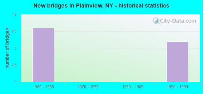
- New bridges - historical statistics
- 81960-1969
- 61990-1999


- Bridge Condition - Deck
- 16.7%Good
- 83.3%Satisfactory

- Bridge Condition - Superstructure
- 14.3%Excellent
- 42.9%Good
- 42.9%Satisfactory

- Bridge Condition - Substructure
- 14.3%Very good
- 42.9%Good
- 28.6%Satisfactory
- 14.3%Fair
Find on map >> Show street view
Structure Number: 1037909, Location: 1.4 MI S JCT SH 135 & SSP (Lat: 40.761919, Lng: -73.476767), Route carried "on" structure: State highway 135, Year Built: 1963, Status: Open, Structure Length: 1.92m (6.30ft), Average Daily Traffic: 86,041 (year 2018), Truck Traffic: 5%, Average Future Daily Traffic: 102,345 (year 2040), Design Load: H 20, Features Intersected: HAY PATH ROAD
Minimum Vertical Clearance: 30+ m (98+ ft), Kilometerpoint: 11.247, Lanes on structure: 6, Lanes under structure: 2, Base Highway Network: Yes, Owner: State Highway Agency, Approaching Roadway Width: 29.9m (98.1ft), Skew: 23 degrees, Material/Design: Steel, Design/Construction: Stringer/Multi-beam, Number Of Spans In Main Unit: 1, Length of Maximum Span: 17.3m (56.8ft), Curb-To-Curb Width: 29.7m (97.4ft), Out-to-Out Width: 32.1m (105.3ft)
Condition: Deck: Satisfactory, Superstructure: Good, Substructure: Satisfactory, Operating Rating: 80.7 metric tons, Method Used To Determine Operating Rating: Load Factor (LF), Inventory Rating: 48.1 metric tons, Method Used To Determine Inventory Rating: Load Factor (LF), Structural Evaluation: Equal to present minimum criteria, Deck Geometry: Superior to present desirable criteria, Underclear: Meets minimum limits, Approach Roadway Alignment: Equal to present desirable criteria, Length Of Structure Improvement: 1.92m (6.30ft), Designated Inspection Frequency: Every 24 months, Inspection Date: June 2021, Bridge Improvement Cost: $5,447,000, Roadway Improvement Cost: $3,190,000, Total Project Cost: $8,636,000 ( Estimate for 2021), Deck Structure Type: Concrete Cast-file-Place, Wearing Surface/Protective System: Wearing Surface: Bituminous
Find on map >> Show street view
Structure Number: 103791, Location: .5 MI S JCT RTE 135+SSP (Lat: 40.773794, Lng: -73.481275), Route carried "on" structure: Other road , Year Built: 1962, Status: Open, Structure Length: 3.44m (11.29ft), Average Daily Traffic: 22,563 (year 2020), Truck Traffic: 4%, Average Future Daily Traffic: 27,409 (year 2040), Design Load: H 20, Features Intersected: 135 135 03011089, RTE 13, Facility Carried by Structure: OLD COUNTRY ROAD
Minimum Vertical Clearance: 30+ m (98+ ft), Kilometerpoint: 14.883, Lanes on structure: 4, Lanes under structure: 6, Owner: State Highway Agency, Approaching Roadway Width: 18.9m (62.0ft), Material/Design: Steel, Design/Construction: Stringer/Multi-beam, Number Of Spans In Main Unit: 2, Length of Maximum Span: 16.4m (53.8ft), Curb or Sidewalk Widths: Left: 1.8m (5.9ft), Right: 1.8m (5.9ft), Curb-To-Curb Width: 18.9m (62.0ft), Out-to-Out Width: 23.1m (75.8ft)
Condition: Deck: Satisfactory, Superstructure: Satisfactory, Substructure: Fair, Operating Rating: 76.2 metric tons, Method Used To Determine Operating Rating: Load Factor (LF), Inventory Rating: 45.4 metric tons, Method Used To Determine Inventory Rating: Load Factor (LF), Structural Evaluation: Somewhat better than minimum adequacy, Deck Geometry: Equal to present minimum criteria, Underclear: High priority of corrective action, Approach Roadway Alignment: Equal to present desirable criteria, Length Of Structure Improvement: 3.44m (11.29ft), Designated Inspection Frequency: Every 24 months, Inspection Date: June 2021, Bridge Improvement Cost: $4,573,000, Roadway Improvement Cost: $2,678,000, Total Project Cost: $7,251,000 ( Estimate for 2021), Deck Structure Type: Concrete Cast-file-Place, Wearing Surface/Protective System: Wearing Surface: Bituminous, Membrane: Other
Find on map >> Show street view
Structure Number: 103792, Location: JCT SH 135 & SSP (Lat: 40.781728, Lng: -73.482908), Route carried "on" structure: Other road , Year Built: 1962, Status: Open, Structure Length: 3.44m (11.29ft), Average Daily Traffic: 7,761 (year 2018), Truck Traffic: 3%, Average Future Daily Traffic: 9,602 (year 2040), Design Load: H 20, Features Intersected: 135 135 03011095 SB, RTE, Facility Carried by Structure: SOUTHERN PARKWAY
Minimum Vertical Clearance: 30+ m (98+ ft), Kilometerpoint: 0.547, Lanes on structure: 3, Lanes under structure: 6, Owner: State Highway Agency, Approaching Roadway Width: 12.2m (40.0ft), Skew: 20 degrees, Material/Design: Steel, Design/Construction: Stringer/Multi-beam, Number Of Spans In Main Unit: 2, Length of Maximum Span: 16.4m (53.8ft), Curb or Sidewalk Widths: Left: 1.8m (5.9ft), Right: 1.8m (5.9ft), Curb-To-Curb Width: 12.2m (40.0ft), Out-to-Out Width: 16.4m (53.8ft)
Condition: Deck: Satisfactory, Superstructure: Good, Substructure: Satisfactory, Operating Rating: 84.4 metric tons, Method Used To Determine Operating Rating: Load Factor (LF), Inventory Rating: 50.8 metric tons, Method Used To Determine Inventory Rating: Load Factor (LF), Structural Evaluation: Equal to present minimum criteria, Deck Geometry: Meets minimum limits, Underclear: High priority of corrective action, Approach Roadway Alignment: Equal to present desirable criteria, Length Of Structure Improvement: 3.44m (11.29ft), Designated Inspection Frequency: Every 24 months, Inspection Date: June 2021, Bridge Improvement Cost: $3,208,000, Roadway Improvement Cost: $1,879,000, Total Project Cost: $5,087,000 ( Estimate for 2021), Deck Structure Type: Concrete Cast-file-Place, Wearing Surface/Protective System: Wearing Surface: Bituminous, Membrane: Preformed Fabric
Find on map >> Show street view
Structure Number: 104925, Location: .4 MI SE JCT NSP & I495 (Lat: 40.795539, Lng: -73.468181), Route carried "on" structure: City street , Year Built: 1996, Status: Open, Structure Length: 4.94m (16.21ft), Average Daily Traffic: 7,108 (year 2020), Truck Traffic: 7%, Average Future Daily Traffic: 8,634 (year 2040), Design Load: HS 25 or greater, Features Intersected: 495I495I0302114, RTE I49, Facility Carried by Structure: SUNNYSIDE BLVD
Minimum Vertical Clearance: 30+ m (98+ ft), Kilometerpoint: 0.805, Lanes on structure: 6, Lanes under structure: 9, Owner: State Highway Agency, Approaching Roadway Width: 21.3m (69.9ft), Skew: 1 degrees, Material/Design: Prestressed concrete, Design/Construction: Box Beam or Girders - Multiple, Number Of Spans In Main Unit: 2, Length of Maximum Span: 25.9m (85.0ft), Curb or Sidewalk Widths: Left: 1.5m (4.9ft), Right: 1.5m (4.9ft), Curb-To-Curb Width: 21.3m (69.9ft), Out-to-Out Width: 25.0m (82.0ft)
Condition: Deck: Satisfactory, Superstructure: Satisfactory, Substructure: Good, Operating Rating: 68.9 metric tons, Method Used To Determine Operating Rating: Load Factor (LF), Inventory Rating: 41.7 metric tons, Method Used To Determine Inventory Rating: Load Factor (LF), Structural Evaluation: Equal to present minimum criteria, Deck Geometry: High priority of replacement, Underclear: High priority of corrective action, Approach Roadway Alignment: Equal to present desirable criteria, Length Of Structure Improvement: 4.93m (16.17ft), Designated Inspection Frequency: Every 24 months, Inspection Date: October 2020, Bridge Improvement Cost: $4,720,000, Roadway Improvement Cost: $2,764,000, Total Project Cost: $7,484,000 ( Estimate for 2021), Wearing Surface/Protective System: Wearing Surface: Monolithic Concrete
Find on map >> Show street view
Structure Number: 1049279, Location: 1.2 MI SE JCT NSP+RTE 495 (Lat: 40.789461, Lng: -73.455564), Route carried "on" structure: Interstate 495, Year Built: 1963, Status: Open, Structure Length: 2.47m (8.10ft), Average Daily Traffic: 147,224 (year 2018), Truck Traffic: 11%, Average Future Daily Traffic: 154,585 (year 2040), Design Load: HS 20, Features Intersected: WASHINGTON AVENUE
Minimum Vertical Clearance: 30+ m (98+ ft), Kilometerpoint: 24.264, Lanes on structure: 8, Lanes under structure: 2, Base Highway Network: Yes, Owner: State Highway Agency, Approaching Roadway Width: 42.4m (139.1ft), Skew: 21 degrees, Material/Design: Concrete, Design/Construction: Frame, Number Of Spans In Main Unit: 1, Length of Maximum Span: 24.3m (79.7ft), Curb-To-Curb Width: 42.3m (138.8ft), Out-to-Out Width: 44.1m (144.7ft)
Condition: Superstructure: Satisfactory, Substructure: Good, Operating Rating: 90.0 metric tons, Method Used To Determine Operating Rating: Field evaluation and documented engineering judgment, Inventory Rating: 32.7 metric tons, Method Used To Determine Inventory Rating: Field evaluation and documented engineering judgment, Structural Evaluation: Equal to present minimum criteria, Deck Geometry: Superior to present desirable criteria, Underclear: Equal to present minimum criteria, Approach Roadway Alignment: Better than present minimum criteria, Length Of Structure Improvement: 2.46m (8.07ft), Designated Inspection Frequency: Every 24 months, Inspection Date: October 2021, Bridge Improvement Cost: $7,056,000, Roadway Improvement Cost: $4,132,000, Total Project Cost: $11,188,000 ( Estimate for 2021), Wearing Surface/Protective System: Wearing Surface: Monolithic Concrete, Membrane: Other
Find on map >> Show street view
Structure Number: 105724, Location: 1.2 MI E JCT NSP & I495 (Lat: 40.789792, Lng: -73.455469), Route carried "on" structure: ServiceState highway 906B, Year Built: 1997, Status: Open, Structure Length: 2.83m (9.28ft), Average Daily Traffic: 4,957 (year 2020), Truck Traffic: 4%, Average Future Daily Traffic: 5,719 (year 2040), Design Load: HS 25 or greater, Features Intersected: WASHINGTON AVENUE
Minimum Vertical Clearance: 30+ m (98+ ft), Kilometerpoint: 0.965, Lanes on structure: 2, Lanes under structure: 2, Base Highway Network: Yes, Owner: State Highway Agency, Approaching Roadway Width: 11.6m (38.1ft), Skew: 3 degrees, Material/Design: Prestressed concrete, Design/Construction: Box Beam or Girders - Multiple, Number Of Spans In Main Unit: 1, Length of Maximum Span: 27.4m (89.9ft), Curb-To-Curb Width: 11.6m (38.1ft), Out-to-Out Width: 12.6m (41.3ft)
Condition: Deck: Satisfactory, Superstructure: Excellent, Substructure: Very good, Operating Rating: 89.8 metric tons, Method Used To Determine Operating Rating: Load Factor (LF), Inventory Rating: 40.8 metric tons, Method Used To Determine Inventory Rating: Load Factor (LF), Structural Evaluation: Equal to present desirable criteria, Deck Geometry: Better than present minimum criteria, Underclear: Equal to present minimum criteria, Approach Roadway Alignment: Equal to present desirable criteria, Length Of Structure Improvement: 2.83m (9.28ft), Designated Inspection Frequency: Every 24 months, Inspection Date: October 2021, Bridge Improvement Cost: $1,744,000, Roadway Improvement Cost: $1,021,000, Total Project Cost: $2,766,000 ( Estimate for 2021), Wearing Surface/Protective System: Wearing Surface: Integral Concrete
Find on map >> Show street view
Structure Number: 105725, Location: 1.2 MI SE JCT NSP & I495 (Lat: 40.788764, Lng: -73.455889), Route carried "on" structure: ServiceState highway 906A, Year Built: 1997, Status: Open, Structure Length: 2.77m (9.09ft), Average Daily Traffic: 8,028 (year 2020), Truck Traffic: 7%, Average Future Daily Traffic: 9,262 (year 2040), Design Load: HS 25 or greater, Features Intersected: WASHINGTON AVENUE
Minimum Vertical Clearance: 30+ m (98+ ft), Kilometerpoint: 24.264, Lanes on structure: 2, Lanes under structure: 2, Base Highway Network: Yes, Owner: State Highway Agency, Approaching Roadway Width: 11.6m (38.1ft), Material/Design: Prestressed concrete, Design/Construction: Box Beam or Girders - Multiple, Number Of Spans In Main Unit: 1, Length of Maximum Span: 26.8m (87.9ft), Curb-To-Curb Width: 11.6m (38.1ft), Out-to-Out Width: 12.6m (41.3ft)
Condition: Deck: Good, Superstructure: Good, Substructure: Good, Operating Rating: 89.8 metric tons, Method Used To Determine Operating Rating: Load Factor (LF), Inventory Rating: 72.6 metric tons, Method Used To Determine Inventory Rating: Load Factor (LF), Structural Evaluation: Better than present minimum criteria, Deck Geometry: Better than present minimum criteria, Underclear: Equal to present minimum criteria, Approach Roadway Alignment: Equal to present desirable criteria, Length Of Structure Improvement: 2.77m (9.09ft), Designated Inspection Frequency: Every 24 months, Inspection Date: October 2021, Bridge Improvement Cost: $1,700,000, Roadway Improvement Cost: $995,000, Total Project Cost: $2,695,000 ( Estimate for 2021), Wearing Surface/Protective System: Wearing Surface: Integral Concrete
Find on map >> Show street view
Structure Number: 1037909, Location: 1.4 MI S JCT SH 135 & SSP (Lat: 40.761919, Lng: -73.476767), Route carried "under" structure: Other road , Year Built: 1963, Structure Length: 0. m, Average Daily Traffic: 7,800 (year 2021), Features Intersected: HAY PATH ROAD, Facility Carried by Structure: RTE 135
Minimum Vertical Clearance: 4.55m (14.93ft), Kilometerpoint: 0.000, Lanes on structure: 6, Lanes under structure: 2, Material/Design: Steel, Design/Construction: Stringer/Multi-beam, Length of Maximum Span: 17.3m (56.8ft)
Find on map >> Show street view
Structure Number: 103791, Location: .5 MI S JCT RTE 135+SSP (Lat: 40.773794, Lng: -73.481275), Route carried "under" structure: State highway 135, Year Built: 1962, Structure Length: 0. m, Average Daily Traffic: 93,032 (year 2002), Features Intersected: 135 135 03011089, RTE 13, Facility Carried by Structure: OLD COUNTRY ROAD
Minimum Vertical Clearance: 4.95m (16.24ft), Kilometerpoint: 12.969, Lanes on structure: 4, Lanes under structure: 3, Material/Design: Steel, Design/Construction: Stringer/Multi-beam, Length of Maximum Span: 16.4m (53.8ft)
Find on map >> Show street view
Structure Number: 103792, Location: JCT SH 135 & SSP (Lat: 40.781728, Lng: -73.482908), Route carried "under" structure: State highway 135, Year Built: 1962, Structure Length: 0. m, Average Daily Traffic: 93,032 (year 2002), Features Intersected: 135 135 03011095 SB, RTE, Facility Carried by Structure: SOUTHERN PARKWAY
Minimum Vertical Clearance: 4.47m (14.67ft), Kilometerpoint: 13.837, Lanes on structure: 3, Lanes under structure: 3, Material/Design: Steel, Design/Construction: Stringer/Multi-beam, Length of Maximum Span: 16.4m (53.8ft)
Find on map >> Show street view
Structure Number: 104925, Location: .4 MI SE JCT NSP & I495 (Lat: 40.795539, Lng: -73.468181), Route carried "under" structure: Interstate 495, Year Built: 1996, Structure Length: 0. m, Average Daily Traffic: 120,100 (year 2021), Features Intersected: 495I495I0302114, RTE I49, Facility Carried by Structure: SUNNYSIDE BLVD
Minimum Vertical Clearance: 4.75m (15.58ft), Kilometerpoint: 22.960, Lanes on structure: 6, Lanes under structure: 5, Material/Design: Prestressed concrete, Design/Construction: Box Beam or Girders - Multiple, Length of Maximum Span: 25.9m (85.0ft)
Find on map >> Show street view
Structure Number: 1049279, Location: 1.2 MI SE JCT NSP+RTE 495 (Lat: 40.789461, Lng: -73.455564), Route carried "under" structure: Other road , Year Built: 1963, Structure Length: 0. m, Average Daily Traffic: 4,000 (year 1976), Features Intersected: WASHINGTON AVENUE, Facility Carried by Structure: RTE I495
Minimum Vertical Clearance: 4.62m (15.16ft), Kilometerpoint: 0.000, Lanes on structure: 8, Lanes under structure: 2, Material/Design: Concrete, Design/Construction: Frame, Length of Maximum Span: 24.3m (79.7ft)
Find on map >> Show street view
Structure Number: 105724, Location: 1.2 MI E JCT NSP & I495 (Lat: 40.789792, Lng: -73.455469), Route carried "under" structure: Other road , Year Built: 1997, Structure Length: 0. m, Average Daily Traffic: 4,000 (year 2021), Features Intersected: WASHINGTON AVENUE, Facility Carried by Structure: RTE 906B
Minimum Vertical Clearance: 4.65m (15.26ft), Kilometerpoint: 0.000, Lanes on structure: 2, Lanes under structure: 2, Material/Design: Prestressed concrete, Design/Construction: Box Beam or Girders - Multiple, Length of Maximum Span: 27.4m (89.9ft)
Find on map >> Show street view
Structure Number: 105725, Location: 1.2 MI SE JCT NSP & I495 (Lat: 40.788764, Lng: -73.455889), Route carried "under" structure: Other road , Year Built: 1997, Structure Length: 0. m, Average Daily Traffic: 4,000 (year 1990), Features Intersected: WASHINGTON AVENUE, Facility Carried by Structure: RTE 906A
Minimum Vertical Clearance: 4.65m (15.26ft), Kilometerpoint: 0.000, Lanes on structure: 2, Lanes under structure: 2, Material/Design: Prestressed concrete, Design/Construction: Box Beam or Girders - Multiple, Length of Maximum Span: 26.8m (87.9ft)