Bridge Statistics for Farmington Hills, Michigan (MI)
Condition, Traffic, Stress, Structural Evaluation, Project Costs
- National Bridge Inventory (NBI) Statistics
- 45Number of bridges
- 449ft / 137mTotal length
- $824,000Total costs
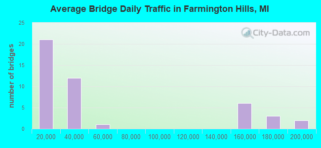
- 2,421,187Total average daily traffic
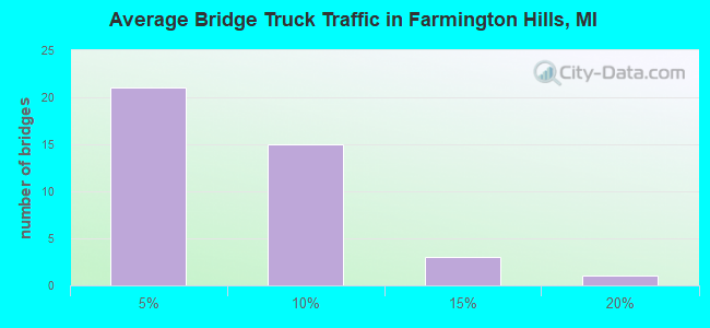
- 167,486Total average daily truck traffic
- National Bridge Inventory (NBI) Registered Bridges for Farmington Hills
- No street view available for this location
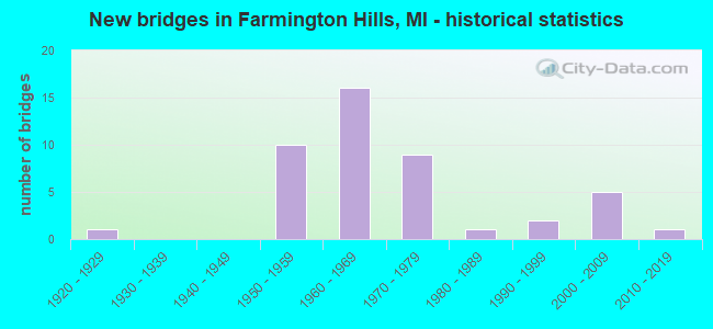
- New bridges - historical statistics
- 11920-1929
- 101950-1959
- 161960-1969
- 91970-1979
- 11980-1989
- 21990-1999
- 52000-2009
- 12010-2019
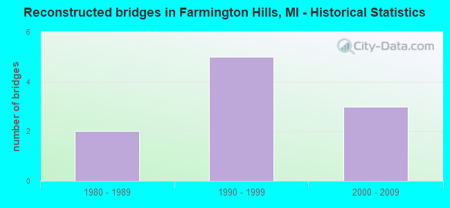
- Reconstructed bridges - Historical Statistics
- 21980-1989
- 51990-1999
- 32000-2009
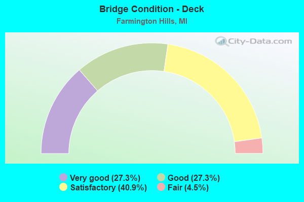
- Bridge Condition - Deck
- 27.3%Very good
- 27.3%Good
- 40.9%Satisfactory
- 4.5%Fair
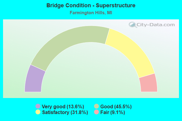
- Bridge Condition - Superstructure
- 13.6%Very good
- 45.5%Good
- 31.8%Satisfactory
- 9.1%Fair
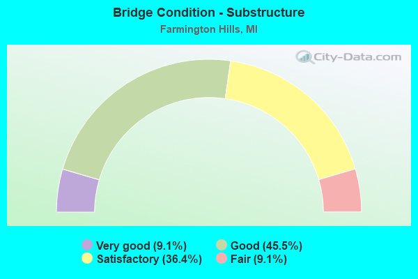
- Bridge Condition - Substructure
- 9.1%Very good
- 45.5%Good
- 36.4%Satisfactory
- 9.1%Fair
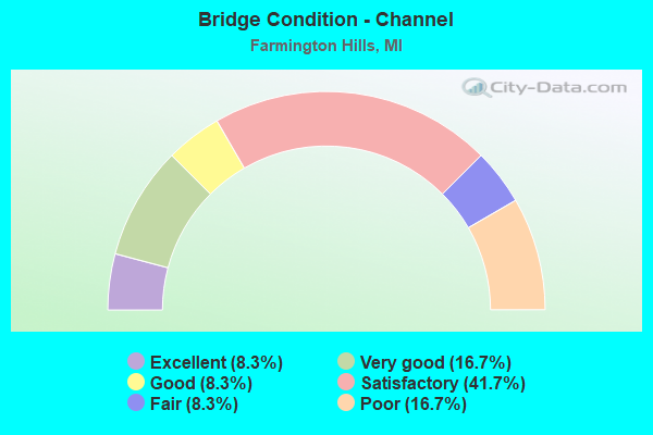
- Bridge Condition - Channel
- 8.3%Excellent
- 16.7%Very good
- 8.3%Good
- 41.7%Satisfactory
- 8.3%Fair
- 16.7%Poor
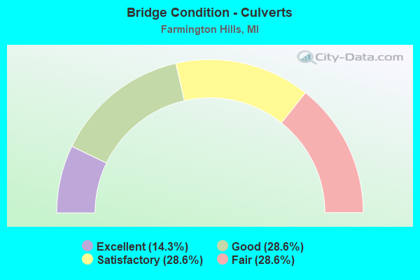
- Bridge Condition - Culverts
- 14.3%Excellent
- 28.6%Good
- 28.6%Satisfactory
- 28.6%Fair
Find on map >> Show street view
Structure Number: 79, Location: 1.5 MI N OF DEERTON (Lat: 46.503850, Lng: -87.043128), Route carried "on" structure: Other road , Year Built: 2006, Status: Open, Structure Length: 1.83m (6.00ft), Average Daily Traffic: 50 (year 2005), Average Future Daily Traffic: 50 (year 2025), Design Load: HS 20, Features Intersected: LAUGHING WHITEFISH RIVER, Facility Carried by Structure: NORTH POINT DRIVE
Minimum Vertical Clearance: 30.48m (100.00ft), Kilometerpoint: 1.090, Lanes on structure: 1, Owner: County Highway Agency, Approaching Roadway Width: 8.5m (27.9ft), Skew: 3 degrees, Material/Design: Prestressed concrete, Design/Construction: Box Beam or Girders - Multiple, Number Of Spans In Main Unit: 1, Length of Maximum Span: 17.1m (56.1ft), Curb-To-Curb Width: 8.5m (27.9ft), Out-to-Out Width: 8.5m (27.9ft)
Condition: Deck: Very good, Superstructure: Very good, Substructure: Very good, Channel: Very good, Operating Rating: 93.0 metric tons, Method Used To Determine Operating Rating: Load Factor (LF) rating reported by rating factor (RF) method using MS18 loading, Inventory Rating: 55.7 metric tons, Method Used To Determine Inventory Rating: Load Factor (LF) rating reported by rating factor (RF) method using MS18 loading, Structural Evaluation: Equal to present desirable criteria, Deck Geometry: Better than present minimum criteria, Waterway Adequacy: Equal to present desirable criteria, Approach Roadway Alignment: Equal to present desirable criteria, Designated Inspection Frequency: Every 24 months, Inspection Date: September 2021, Deck Structure Type: Concrete Precast Panels, Wearing Surface/Protective System: Wearing Surface: Bituminous, Membrane: Preformed Fabric, Deck Protection: Epoxy Coated Reinforcing
Find on map >> Show street view
Structure Number: 779, Location: 2.8 MI SW OF US-12 (Lat: 41.770036, Lng: -86.736628), Route carried "on" structure: County highway 1104, Year Built: 1971, Year Reconstructed: 2011, Status: Open, Structure Length: 7.87m (25.82ft), Average Daily Traffic: 625 (year 1984), Truck Traffic: 3%, Average Future Daily Traffic: 720 (year 2004), Design Load: H 15, Features Intersected: I-94, Facility Carried by Structure: WILSON ROAD
Minimum Vertical Clearance: 30.48m (100.00ft), Kilometerpoint: 3.975, Lanes on structure: 2, Lanes under structure: 7, Owner: State Highway Agency, Approaching Roadway Width: 9.8m (32.2ft), Skew: 4 degrees, Material/Design: Steel, Design/Construction: Stringer/Multi-beam, Number Of Spans In Main Unit: 2, Length of Maximum Span: 41.1m (134.8ft), Curb-To-Curb Width: 12.2m (40.0ft), Out-to-Out Width: 13.4m (44.0ft)
Condition: Deck: Good, Superstructure: Fair, Substructure: Satisfactory, Operating Rating: 68.2 metric tons, Method Used To Determine Operating Rating: Load Factor (LF), Inventory Rating: 40.8 metric tons, Method Used To Determine Inventory Rating: Load Factor (LF), Structural Evaluation: Somewhat better than minimum adequacy, Deck Geometry: Equal to present desirable criteria, Underclear: High priority of corrective action, Approach Roadway Alignment: Equal to present desirable criteria, Designated Inspection Frequency: Every 24 months, Inspection Date: October 2020, Deck Structure Type: Concrete Cast-file-Place, Wearing Surface/Protective System: Wearing Surface: Latex Concrete, Deck Protection: Epoxy Coated Reinforcing
Find on map >> Show street view
Structure Number: 781, Location: 0.5 MI E OF NEW BUFFALO (Lat: 41.788703, Lng: -86.715822), Route carried "on" structure: County highway , Year Built: 1964, Year Reconstructed: 1986, Status: Open, Structure Length: 8.42m (27.62ft), Average Daily Traffic: 676 (year 2012), Truck Traffic: 3%, Average Future Daily Traffic: 777 (year 2032), Design Load: H 15, Features Intersected: I-94, Facility Carried by Structure: MAUDLIN ROAD
Minimum Vertical Clearance: 30.48m (100.00ft), Kilometerpoint: 2.041, Lanes on structure: 2, Lanes under structure: 8, Owner: State Highway Agency, Approaching Roadway Width: 6.8m (22.3ft), Material/Design: Steel, Design/Construction: Stringer/Multi-beam, Number Of Spans In Main Unit: 4, Length of Maximum Span: 24.9m (81.7ft), Curb-To-Curb Width: 8.5m (27.9ft), Out-to-Out Width: 9.6m (31.5ft)
Condition: Deck: Satisfactory, Superstructure: Fair, Substructure: Good, Operating Rating: 68.0 metric tons, Method Used To Determine Operating Rating: Load Factor (LF) rating reported by rating factor (RF) method using MS18 loading, Inventory Rating: 40.8 metric tons, Method Used To Determine Inventory Rating: Load Factor (LF) rating reported by rating factor (RF) method using MS18 loading, Structural Evaluation: Somewhat better than minimum adequacy, Deck Geometry: Somewhat better than minimum adequacy, Underclear: Somewhat better than minimum adequacy, Approach Roadway Alignment: Better than present minimum criteria, Designated Inspection Frequency: Every 24 months, Inspection Date: October 2020, Deck Structure Type: Concrete Cast-file-Place, Wearing Surface/Protective System: Wearing Surface: Epoxy Overlay
Find on map >> Show street view
Structure Number: 1403, Location: 0.3 MI N OF I-94BL (Lat: 42.324261, Lng: -85.197581), Route carried "on" structure: City street 2011, Year Built: 2003, Status: Open, Structure Length: 5.51m (18.08ft), Average Daily Traffic: 3,700 (year 2019), Truck Traffic: 7%, Average Future Daily Traffic: 6,000 (year 2030), Design Load: HS 20, Features Intersected: KALAMAZOO RIVER, Facility Carried by Structure: KENDALL STREET N
Minimum Vertical Clearance: 30.48m (100.00ft), Kilometerpoint: 0.697, Lanes on structure: 2, Owner: City or Municipal Highway Agency, Approaching Roadway Width: 17.4m (57.1ft), Material/Design: Prestressed concrete, Design/Construction: Stringer/Multi-beam, Number Of Spans In Main Unit: 2, Length of Maximum Span: 27.6m (90.6ft), Curb or Sidewalk Widths: Left: 1.6m (5.2ft), Right: 1.6m (5.2ft), Curb-To-Curb Width: 14.0m (45.9ft), Out-to-Out Width: 18.0m (59.1ft)
Condition: Deck: Very good, Superstructure: Very good, Substructure: Very good, Channel: Very good, Operating Rating: 71.3 metric tons, Method Used To Determine Operating Rating: Load Factor (LF) rating reported by rating factor (RF) method using MS18 loading, Inventory Rating: 43.7 metric tons, Method Used To Determine Inventory Rating: Load Factor (LF) rating reported by rating factor (RF) method using MS18 loading, Structural Evaluation: Equal to present desirable criteria, Deck Geometry: Superior to present desirable criteria, Waterway Adequacy: Equal to present minimum criteria, Approach Roadway Alignment: Better than present minimum criteria, Designated Inspection Frequency: Every 24 months, Inspection Date: August 2021, Deck Structure Type: Concrete Cast-file-Place, Wearing Surface/Protective System: Wearing Surface: Monolithic Concrete, Deck Protection: Epoxy Coated Reinforcing
Find on map >> Show street view
Structure Number: 3114, Location: 2.0 MI S OF ISABELLA COL (Lat: 43.436903, Lng: -84.677078), Route carried "on" structure: County highway , Year Built: 1964, Status: Open, Structure Length: 6.34m (20.80ft), Average Daily Traffic: 467 (year 1996), Truck Traffic: 1%, Average Future Daily Traffic: 280 (year 1977), Design Load: H 15, Features Intersected: US-127, Facility Carried by Structure: JEFFERSON RD
Minimum Vertical Clearance: 30.48m (100.00ft), Kilometerpoint: 13.646, Lanes on structure: 2, Lanes under structure: 4, Owner: State Highway Agency, Approaching Roadway Width: 10.9m (35.8ft), Material/Design: Prestressed concrete, Design/Construction: Stringer/Multi-beam, Number Of Spans In Main Unit: 4, Length of Maximum Span: 21.9m (71.9ft), Curb or Sidewalk Widths: Left: 0.7m (2.3ft), Right: 0.7m (2.3ft), Curb-To-Curb Width: 7.3m (24.0ft), Out-to-Out Width: 9.5m (31.2ft)
Condition: Deck: Good, Superstructure: Satisfactory, Substructure: Satisfactory, Operating Rating: 70.3 metric tons, Method Used To Determine Operating Rating: Load Factor (LF) rating reported by rating factor (RF) method using MS18 loading, Inventory Rating: 25.6 metric tons, Method Used To Determine Inventory Rating: Load Factor (LF) rating reported by rating factor (RF) method using MS18 loading, Structural Evaluation: Equal to present minimum criteria, Deck Geometry: Meets minimum limits, Underclear: Somewhat better than minimum adequacy, Approach Roadway Alignment: Equal to present desirable criteria, Designated Inspection Frequency: Every 24 months, Inspection Date: May 2021, Deck Structure Type: Concrete Cast-file-Place, Wearing Surface/Protective System: Wearing Surface: Bituminous
Find on map >> Show street view
Structure Number: 779, Location: 2.0 MI SE OF FARMINGTON (Lat: 42.451603, Lng: -83.351822), Route carried "on" structure: State highway 5, Year Built: 1956, Status: Open, Structure Length: 0.67m (2.20ft), Average Daily Traffic: 33,628 (year 2007), Truck Traffic: 3%, Average Future Daily Traffic: 20,730 (year 2018), Design Load: HS 20, Features Intersected: UPPER ROUGE RIVER
Minimum Vertical Clearance: 30.48m (100.00ft), Kilometerpoint: 28.139, Lanes on structure: 5, Base Highway Network: Yes (Inventory Route: 65, Subroute: 3), Owner: State Highway Agency, Approaching Roadway Width: 20.7m (67.9ft), Skew: 2 degrees, Material/Design: Concrete, Design/Construction: Culvert, Number Of Spans In Main Unit: 2, Length of Maximum Span: 3.0m (9.8ft), Out-to-Out Width: 85.0m (278.9ft)
Condition: Channel: Satisfactory, Culverts: Good, Operating Rating: 97.2 metric tons, Method Used To Determine Operating Rating: Load Factor (LF) rating reported by rating factor (RF) method using MS18 loading, Inventory Rating: 89.7 metric tons, Method Used To Determine Inventory Rating: Load Factor (LF) rating reported by rating factor (RF) method using MS18 loading, Structural Evaluation: Better than present minimum criteria, Waterway Adequacy: Equal to present minimum criteria, Approach Roadway Alignment: Equal to present minimum criteria, Designated Inspection Frequency: Every 24 months, Inspection Date: November 2020
Find on map >> Show street view
Structure Number: 7805, Location: 2MI W OF FARMINGTON (Lat: 42.468364, Lng: -83.417175), Route carried "on" structure: Business Interstate 96, Year Built: 1957, Status: Open, Structure Length: 7.50m (24.61ft), Average Daily Traffic: 32,580 (year 2017), Truck Traffic: 3%, Average Future Daily Traffic: 36,675 (year 2039), Design Load: H 20, Features Intersected: M-5
Minimum Vertical Clearance: 30.48m (100.00ft), Kilometerpoint: 23.278, Lanes on structure: 4, Lanes under structure: 4, Base Highway Network: Yes (Inventory Route: 410, Subroute: 42), Owner: State Highway Agency, Approaching Roadway Width: 17.0m (55.8ft), Skew: 1 degrees, Material/Design: Steel, Design/Construction: Stringer/Multi-beam, Number Of Spans In Main Unit: 4, Length of Maximum Span: 20.7m (67.9ft), Curb or Sidewalk Widths: Left: 1.7m (5.6ft), Right: 0.0m, Curb-To-Curb Width: 14.6m (47.9ft), Out-to-Out Width: 17.6m (57.7ft)
Condition: Deck: Satisfactory, Superstructure: Satisfactory, Substructure: Good, Operating Rating: 62.9 metric tons, Method Used To Determine Operating Rating: Load Factor (LF) rating reported by rating factor (RF) method using MS18 loading, Inventory Rating: 32.4 metric tons, Method Used To Determine Inventory Rating: Load Factor (LF) rating reported by rating factor (RF) method using MS18 loading, Structural Evaluation: Equal to present minimum criteria, Deck Geometry: High priority of replacement, Underclear: High priority of corrective action, Approach Roadway Alignment: Better than present minimum criteria, Designated Inspection Frequency: Every 24 months, Inspection Date: November 2020, Deck Structure Type: Concrete Cast-file-Place, Wearing Surface/Protective System: Wearing Surface: Latex Concrete, Deck Protection: Epoxy Coated Reinforcing
Find on map >> Show street view
Structure Number: 7806, Location: 4.0 MI NW OF WAYNE CO LIN (Lat: 42.459144, Lng: -83.395675), Route carried "on" structure: City street , Year Built: 1957, Status: Open, Structure Length: 4.18m (13.71ft), Average Daily Traffic: 7,275 (year 2017), Truck Traffic: 1%, Average Future Daily Traffic: 8,125 (year 2039), Design Load: H 15, Features Intersected: M-5, Facility Carried by Structure: DRAKE RD
Minimum Vertical Clearance: 30.48m (100.00ft), Kilometerpoint: 0.510, Lanes on structure: 2, Lanes under structure: 4, Owner: State Highway Agency, Approaching Roadway Width: 7.9m (25.9ft), Skew: 1 degrees, Material/Design: Steel, Design/Construction: Stringer/Multi-beam, Number Of Spans In Main Unit: 2, Length of Maximum Span: 20.9m (68.6ft), Curb or Sidewalk Widths: Left: 1.2m (3.9ft), Right: 1.2m (3.9ft), Curb-To-Curb Width: 8.4m (27.6ft), Out-to-Out Width: 10.4m (34.1ft)
Condition: Deck: Good, Superstructure: Good, Substructure: Good, Operating Rating: 60.3 metric tons, Method Used To Determine Operating Rating: Load Factor (LF) rating reported by rating factor (RF) method using MS18 loading, Inventory Rating: 36.0 metric tons, Method Used To Determine Inventory Rating: Load Factor (LF) rating reported by rating factor (RF) method using MS18 loading, Structural Evaluation: Better than present minimum criteria, Deck Geometry: High priority of replacement, Underclear: Meets minimum limits, Approach Roadway Alignment: Better than present minimum criteria, Designated Inspection Frequency: Every 24 months, Inspection Date: October 2021, Bridge Improvement Cost: $699,000, Roadway Improvement Cost: $70,000, Total Project Cost: $824,000, Deck Structure Type: Concrete Cast-file-Place, Wearing Surface/Protective System: Wearing Surface: Monolithic Concrete
Find on map >> Show street view
Structure Number: 7809, Location: 2.0 MI NW OF WAYNE CO LIN (Lat: 42.452642, Lng: -83.355753), Route carried "on" structure: County highway 2059, Year Built: 1957, Year Reconstructed: 1997, Status: Open, Structure Length: 4.39m (14.40ft), Average Daily Traffic: 12,690 (year 1974), Truck Traffic: 3%, Average Future Daily Traffic: 12,690 (year 1977), Design Load: HS 20, Features Intersected: M-5, Facility Carried by Structure: ORCHARD LAKE RD
Minimum Vertical Clearance: 30.48m (100.00ft), Kilometerpoint: 1.263, Lanes on structure: 4, Lanes under structure: 4, Base Highway Network: Yes (Inventory Route: 63, Subroute: 6), Owner: State Highway Agency, Approaching Roadway Width: 10.9m (35.8ft), Material/Design: Steel, Design/Construction: Stringer/Multi-beam, Number Of Spans In Main Unit: 2, Length of Maximum Span: 21.9m (71.9ft), Curb or Sidewalk Widths: Left: 1.3m (4.3ft), Right: 1.3m (4.3ft), Curb-To-Curb Width: 14.7m (48.2ft), Out-to-Out Width: 17.9m (58.7ft)
Condition: Deck: Satisfactory, Superstructure: Satisfactory, Substructure: Satisfactory, Operating Rating: 71.0 metric tons, Method Used To Determine Operating Rating: Load Factor (LF) rating reported by rating factor (RF) method using MS18 loading, Inventory Rating: 42.4 metric tons, Method Used To Determine Inventory Rating: Load Factor (LF) rating reported by rating factor (RF) method using MS18 loading, Structural Evaluation: Equal to present minimum criteria, Deck Geometry: High priority of replacement, Underclear: High priority of corrective action, Approach Roadway Alignment: Equal to present desirable criteria, Designated Inspection Frequency: Every 24 months, Inspection Date: November 2020, Deck Structure Type: Concrete Cast-file-Place, Wearing Surface/Protective System: Wearing Surface: Monolithic Concrete, Deck Protection: Epoxy Coated Reinforcing
Find on map >> Show street view
Structure Number: 781, Location: 0.2 MI E. OF FARMINGTON (Lat: 42.451275, Lng: -83.346236), Route carried "on" structure: State highway 5, Year Built: 1957, Year Reconstructed: 1997, Status: Open, Structure Length: 6.82m (22.38ft), Average Daily Traffic: 16,814 (year 2007), Truck Traffic: 3%, Average Future Daily Traffic: 10,365 (year 2018), Design Load: HS 20, Features Intersected: GRAND RIVER EB CONN
Minimum Vertical Clearance: 30.48m (100.00ft), Kilometerpoint: 28.638, Lanes on structure: 2, Lanes under structure: 2, Base Highway Network: Yes (Inventory Route: 65, Subroute: 4), Owner: State Highway Agency, Approaching Roadway Width: 12.8m (42.0ft), Skew: 5 degrees, Material/Design: Steel, Design/Construction: Stringer/Multi-beam, Number Of Spans In Main Unit: 3, Length of Maximum Span: 23.7m (77.8ft), Curb-To-Curb Width: 14.8m (48.6ft), Out-to-Out Width: 15.8m (51.8ft)
Condition: Deck: Good, Superstructure: Satisfactory, Substructure: Satisfactory, Operating Rating: 85.9 metric tons, Method Used To Determine Operating Rating: Load Factor (LF) rating reported by rating factor (RF) method using MS18 loading, Inventory Rating: 51.5 metric tons, Method Used To Determine Inventory Rating: Load Factor (LF) rating reported by rating factor (RF) method using MS18 loading, Structural Evaluation: Equal to present minimum criteria, Deck Geometry: Superior to present desirable criteria, Underclear: Somewhat better than minimum adequacy, Approach Roadway Alignment: Equal to present desirable criteria, Designated Inspection Frequency: Every 24 months, Inspection Date: November 2020, Deck Structure Type: Concrete Cast-file-Place, Wearing Surface/Protective System: Wearing Surface: Monolithic Concrete, Deck Protection: Epoxy Coated Reinforcing
Find on map >> Show street view
Structure Number: 7899, Location: 0.5 MI NE OF I-96 (Lat: 42.483489, Lng: -83.435658), Route carried "on" structure: County highway 2059, Year Built: 1961, Year Reconstructed: 2001, Status: Open, Structure Length: 8.84m (29.00ft), Average Daily Traffic: 20,000 (year 1974), Truck Traffic: 3%, Average Future Daily Traffic: 20,000 (year 1977), Design Load: H 15, Features Intersected: I-696, Facility Carried by Structure: HAGGERTY RD
Minimum Vertical Clearance: 30.48m (100.00ft), Kilometerpoint: 5.004, Lanes on structure: 2, Lanes under structure: 4, Base Highway Network: Yes (Inventory Route: 63, Subroute: 5), Owner: State Highway Agency, Approaching Roadway Width: 10.3m (33.8ft), Material/Design: Prestressed concrete, Design/Construction: Stringer/Multi-beam, Number Of Spans In Main Unit: 5, Length of Maximum Span: 21.6m (70.9ft), Curb or Sidewalk Widths: Left: 0.7m (2.3ft), Right: 0.7m (2.3ft), Curb-To-Curb Width: 7.9m (25.9ft), Out-to-Out Width: 10.0m (32.8ft)
Condition: Deck: Good, Superstructure: Satisfactory, Substructure: Satisfactory, Operating Rating: 69.7 metric tons, Method Used To Determine Operating Rating: Load Factor (LF) rating reported by rating factor (RF) method using MS18 loading, Inventory Rating: 36.9 metric tons, Method Used To Determine Inventory Rating: Load Factor (LF) rating reported by rating factor (RF) method using MS18 loading, Structural Evaluation: Equal to present minimum criteria, Deck Geometry: High priority of corrective action, Underclear: Somewhat better than minimum adequacy, Approach Roadway Alignment: Equal to present desirable criteria, Designated Inspection Frequency: Every 24 months, Inspection Date: May 2021, Deck Structure Type: Concrete Cast-file-Place, Wearing Surface/Protective System: Wearing Surface: Monolithic Concrete, Deck Protection: Epoxy Coated Reinforcing
Find on map >> Show street view
Structure Number: 79, Location: 1.7 MI NE OF I-96 (Lat: 42.491681, Lng: -83.416889), Route carried "on" structure: City street , Year Built: 2008, Status: Open, Structure Length: 9.17m (30.09ft), Average Daily Traffic: 15,000 (year 1996), Truck Traffic: 3%, Average Future Daily Traffic: 20,764 (year 2007), Design Load: HL 93, Features Intersected: I-696, Facility Carried by Structure: HALSTEAD RD
Minimum Vertical Clearance: 30.48m (100.00ft), Kilometerpoint: 2.747, Lanes on structure: 2, Lanes under structure: 8, Owner: State Highway Agency, Approaching Roadway Width: 18.3m (60.0ft), Skew: 2 degrees, Material/Design: Steel continuous, Design/Construction: Stringer/Multi-beam, Number Of Spans In Main Unit: 4, Length of Maximum Span: 31.1m (102.0ft), Curb or Sidewalk Widths: Left: 3.0m (9.8ft), Right: 3.0m (9.8ft), Curb-To-Curb Width: 19.5m (64.0ft), Out-to-Out Width: 27.2m (89.2ft)
Condition: Deck: Very good, Superstructure: Very good, Substructure: Good, Operating Rating: 64.6 metric tons, Method Used To Determine Operating Rating: Load Factor (LF), Inventory Rating: 38.7 metric tons, Method Used To Determine Inventory Rating: Load Factor (LF), Structural Evaluation: Better than present minimum criteria, Deck Geometry: Superior to present desirable criteria, Underclear: Meets minimum limits, Approach Roadway Alignment: Equal to present desirable criteria, Designated Inspection Frequency: Every 24 months, Inspection Date: March 2020, Deck Structure Type: Concrete Cast-file-Place, Wearing Surface/Protective System: Wearing Surface: Monolithic Concrete, Deck Protection: Epoxy Coated Reinforcing
Find on map >> Show street view
Structure Number: 7901, Location: 2.7MI E OF I-96 OVER DRAK (Lat: 42.493972, Lng: -83.397467), Route carried "on" structure: Interstate 696, Year Built: 1960, Year Reconstructed: 2009, Status: Open, Structure Length: 3.32m (10.89ft), Average Daily Traffic: 167,300 (year 2008), Truck Traffic: 7%, Average Future Daily Traffic: 177,600 (year 2028), Design Load: HS 20+Mod, Features Intersected: DRAKE RD
Minimum Vertical Clearance: 30.48m (100.00ft), Kilometerpoint: 4.207, Lanes on structure: 8, Lanes under structure: 2, Base Highway Network: Yes (Inventory Route: 71, Subroute: 1), Owner: State Highway Agency, Approaching Roadway Width: 36.2m (118.8ft), Skew: 30 degrees, Material/Design: Prestressed concrete, Design/Construction: Stringer/Multi-beam, Number Of Spans In Main Unit: 3, Length of Maximum Span: 12.4m (40.7ft), Curb-To-Curb Width: 42.7m (140.1ft), Out-to-Out Width: 43.7m (143.4ft)
Condition: Deck: Very good, Superstructure: Good, Substructure: Good, Operating Rating: 55.5 metric tons, Method Used To Determine Operating Rating: Load Factor (LF), Inventory Rating: 33.2 metric tons, Method Used To Determine Inventory Rating: Load Factor (LF), Structural Evaluation: Better than present minimum criteria, Deck Geometry: Superior to present desirable criteria, Underclear: High priority of corrective action, Approach Roadway Alignment: Equal to present desirable criteria, Designated Inspection Frequency: Every 24 months, Inspection Date: July 2020, Deck Structure Type: Concrete Cast-file-Place, Wearing Surface/Protective System: Wearing Surface: Monolithic Concrete, Deck Protection: Epoxy Coated Reinforcing
Find on map >> Show street view
Structure Number: 7902, Location: 3.7 MI E OF I-96 (Lat: 42.495061, Lng: -83.378061), Route carried "on" structure: City street 2059, Year Built: 1962, Year Reconstructed: 1997, Status: Open, Structure Length: 7.87m (25.82ft), Average Daily Traffic: 19,600 (year 1996), Truck Traffic: 5%, Average Future Daily Traffic: 27,130 (year 2007), Design Load: HS 20, Features Intersected: I-696, Facility Carried by Structure: FARMINGTON RD
Minimum Vertical Clearance: 30.48m (100.00ft), Kilometerpoint: 3.396, Lanes on structure: 2, Lanes under structure: 8, Owner: State Highway Agency, Approaching Roadway Width: 10.9m (35.8ft), Material/Design: Prestressed concrete, Design/Construction: Stringer/Multi-beam, Number Of Spans In Main Unit: 4, Length of Maximum Span: 21.5m (70.5ft), Curb or Sidewalk Widths: Left: 1.2m (3.9ft), Right: 1.2m (3.9ft), Curb-To-Curb Width: 9.6m (31.5ft), Out-to-Out Width: 10.6m (34.8ft)
Condition: Deck: Very good, Superstructure: Satisfactory, Substructure: Satisfactory, Operating Rating: 67.7 metric tons, Method Used To Determine Operating Rating: Load Factor (LF) rating reported by rating factor (RF) method using MS18 loading, Inventory Rating: 40.5 metric tons, Method Used To Determine Inventory Rating: Load Factor (LF) rating reported by rating factor (RF) method using MS18 loading, Structural Evaluation: Equal to present minimum criteria, Deck Geometry: Meets minimum limits, Underclear: Meets minimum limits, Approach Roadway Alignment: Equal to present minimum criteria, Designated Inspection Frequency: Every 24 months, Inspection Date: May 2021, Deck Structure Type: Concrete Cast-file-Place, Wearing Surface/Protective System: Wearing Surface: Monolithic Concrete, Deck Protection: Epoxy Coated Reinforcing
Find on map >> Show street view
Structure Number: 7903, Location: 4.7 MI E OF I-96 (Lat: 42.496025, Lng: -83.358472), Route carried "on" structure: County highway 2059, Year Built: 1962, Year Reconstructed: 1988, Status: Open, Structure Length: 7.25m (23.79ft), Average Daily Traffic: 36,700 (year 2008), Truck Traffic: 5%, Average Future Daily Traffic: 46,600 (year 2028), Design Load: HS 20, Features Intersected: I-696, Facility Carried by Structure: ORCHARD LAKE RD
Minimum Vertical Clearance: 30.48m (100.00ft), Kilometerpoint: 4.419, Lanes on structure: 7, Lanes under structure: 9, Base Highway Network: Yes (Inventory Route: 63, Subroute: 3), Owner: State Highway Agency, Approaching Roadway Width: 35.3m (115.8ft), Material/Design: Prestressed concrete, Design/Construction: Stringer/Multi-beam, Number Of Spans In Main Unit: 4, Length of Maximum Span: 24.7m (81.0ft), Curb or Sidewalk Widths: Left: 2.2m (7.2ft), Right: 0.0m, Curb-To-Curb Width: 36.5m (119.8ft), Out-to-Out Width: 37.6m (123.4ft)
Condition: Deck: Fair, Superstructure: Good, Substructure: Good, Operating Rating: 62.4 metric tons, Method Used To Determine Operating Rating: Load Factor (LF), Inventory Rating: 37.3 metric tons, Method Used To Determine Inventory Rating: Load Factor (LF), Structural Evaluation: Better than present minimum criteria, Deck Geometry: Superior to present desirable criteria, Underclear: Somewhat better than minimum adequacy, Approach Roadway Alignment: Equal to present desirable criteria, Designated Inspection Frequency: Every 24 months, Other Special Inspection Frequency: Every 24 months, Inspection Date: March 2020, Other Special Inspection Date: March 2021, Deck Structure Type: Concrete Cast-file-Place, Wearing Surface/Protective System: Wearing Surface: Latex Concrete, Deck Protection: Epoxy Coated Reinforcing
Find on map >> Show street view
Structure Number: 7904, Location: 5.7 MI E OF I-96 (Lat: 42.492761, Lng: -83.338775), Route carried "on" structure: County highway 2059, Year Built: 1961, Year Reconstructed: 2002, Status: Open, Structure Length: 7.24m (23.75ft), Average Daily Traffic: 16,900 (year 2000), Truck Traffic: 9%, Average Future Daily Traffic: 22,200 (year 2025), Design Load: HS 20, Features Intersected: I-696, Facility Carried by Structure: MIDDLEBELT RD
Minimum Vertical Clearance: 30.48m (100.00ft), Kilometerpoint: 5.689, Lanes on structure: 2, Lanes under structure: 8, Owner: State Highway Agency, Approaching Roadway Width: 10.9m (35.8ft), Material/Design: Steel, Design/Construction: Stringer/Multi-beam, Number Of Spans In Main Unit: 4, Length of Maximum Span: 23.9m (78.4ft), Curb or Sidewalk Widths: Left: 0.0m, Right: 1.5m (4.9ft), Curb-To-Curb Width: 9.8m (32.2ft), Out-to-Out Width: 12.5m (41.0ft)
Condition: Deck: Satisfactory, Superstructure: Good, Substructure: Satisfactory, Operating Rating: 72.3 metric tons, Method Used To Determine Operating Rating: Load Factor (LF) rating reported by rating factor (RF) method using MS18 loading, Inventory Rating: 43.1 metric tons, Method Used To Determine Inventory Rating: Load Factor (LF) rating reported by rating factor (RF) method using MS18 loading, Structural Evaluation: Equal to present minimum criteria, Deck Geometry: Meets minimum limits, Underclear: Meets minimum limits, Approach Roadway Alignment: Equal to present desirable criteria, Designated Inspection Frequency: Every 24 months, Inspection Date: May 2021, Deck Structure Type: Concrete Cast-file-Place, Wearing Surface/Protective System: Wearing Surface: Monolithic Concrete, Deck Protection: Epoxy Coated Reinforcing
Find on map >> Show street view
Structure Number: 8124, Location: S OF I-96/I-696 INTECHNG (Lat: 42.470883, Lng: -83.431156), Route carried "on" structure: City street 2059, Year Built: 1972, Status: Open, Structure Length: 12.82m (42.06ft), Average Daily Traffic: 21,500 (year 1994), Truck Traffic: 3%, Average Future Daily Traffic: 31,573 (year 2007), Design Load: HS 20, Features Intersected: I-275, I-96, Facility Carried by Structure: GRAND RIVER AVE
Minimum Vertical Clearance: 30.48m (100.00ft), Kilometerpoint: 22.038, Lanes on structure: 3, Lanes under structure: 10, Owner: State Highway Agency, Approaching Roadway Width: 18.2m (59.7ft), Skew: 1 degrees, Material/Design: Steel, Design/Construction: Stringer/Multi-beam, Number Of Spans In Main Unit: 5, Length of Maximum Span: 40.8m (133.9ft), Curb-To-Curb Width: 17.8m (58.4ft), Out-to-Out Width: 19.0m (62.3ft)
Condition: Deck: Satisfactory, Superstructure: Good, Substructure: Good, Operating Rating: 82.3 metric tons, Method Used To Determine Operating Rating: Load Factor (LF) rating reported by rating factor (RF) method using MS18 loading, Inventory Rating: 49.2 metric tons, Method Used To Determine Inventory Rating: Load Factor (LF) rating reported by rating factor (RF) method using MS18 loading, Structural Evaluation: Better than present minimum criteria, Deck Geometry: Superior to present desirable criteria, Underclear: Equal to present minimum criteria, Approach Roadway Alignment: Equal to present desirable criteria, Designated Inspection Frequency: Every 24 months, Inspection Date: December 2020, Deck Structure Type: Concrete Cast-file-Place, Wearing Surface/Protective System: Wearing Surface: Epoxy Overlay
Find on map >> Show street view
Structure Number: 8125, Location: 1 MI NW OF FARMINGTON (Lat: 42.468125, Lng: -83.431139), Route carried "on" structure: County highway 2059, Year Built: 1971, Status: Open, Structure Length: 12.16m (39.90ft), Average Daily Traffic: 20,600 (year 2008), Truck Traffic: 5%, Average Future Daily Traffic: 20,700 (year 2028), Design Load: H 20, Features Intersected: I-96, Facility Carried by Structure: TEN MILE RD
Minimum Vertical Clearance: 30.48m (100.00ft), Kilometerpoint: 19.332, Lanes on structure: 4, Lanes under structure: 9, Owner: State Highway Agency, Approaching Roadway Width: 21.6m (70.9ft), Material/Design: Steel, Design/Construction: Stringer/Multi-beam, Number Of Spans In Main Unit: 5, Length of Maximum Span: 37.1m (121.7ft), Curb-To-Curb Width: 20.7m (67.9ft), Out-to-Out Width: 22.1m (72.5ft)
Condition: Deck: Good, Superstructure: Satisfactory, Substructure: Satisfactory, Operating Rating: 60.3 metric tons, Method Used To Determine Operating Rating: Load Factor (LF) rating reported by rating factor (RF) method using MS18 loading, Inventory Rating: 36.3 metric tons, Method Used To Determine Inventory Rating: Load Factor (LF) rating reported by rating factor (RF) method using MS18 loading, Structural Evaluation: Equal to present minimum criteria, Deck Geometry: Superior to present desirable criteria, Underclear: Equal to present minimum criteria, Approach Roadway Alignment: Equal to present desirable criteria, Designated Inspection Frequency: Every 24 months, Inspection Date: December 2020, Deck Structure Type: Concrete Cast-file-Place, Wearing Surface/Protective System: Wearing Surface: Epoxy Overlay
Find on map >> Show street view
Structure Number: 8126, Location: 1 MI W OF FARMINGTON (Lat: 42.453575, Lng: -83.431519), Route carried "on" structure: Interstate 96, Year Built: 1971, Status: Open, Structure Length: 2.77m (9.09ft), Average Daily Traffic: 182,700 (year 2008), Truck Traffic: 10%, Average Future Daily Traffic: 201,900 (year 2028), Design Load: HS 20+Mod, Features Intersected: 9 MILE RD
Minimum Vertical Clearance: 30.48m (100.00ft), Kilometerpoint: 4.815, Lanes on structure: 4, Lanes under structure: 2, Base Highway Network: Yes (Inventory Route: 63, Subroute: 2), Owner: State Highway Agency, Approaching Roadway Width: 21.6m (70.9ft), Material/Design: Steel, Design/Construction: Stringer/Multi-beam, Number Of Spans In Main Unit: 1, Length of Maximum Span: 27.7m (90.9ft), Curb-To-Curb Width: 21.5m (70.5ft), Out-to-Out Width: 22.7m (74.5ft)
Condition: Deck: Satisfactory, Superstructure: Good, Substructure: Good, Operating Rating: 77.1 metric tons, Method Used To Determine Operating Rating: Load Factor (LF) rating reported by rating factor (RF) method using MS18 loading, Inventory Rating: 46.3 metric tons, Method Used To Determine Inventory Rating: Load Factor (LF) rating reported by rating factor (RF) method using MS18 loading, Structural Evaluation: Better than present minimum criteria, Deck Geometry: Better than present minimum criteria, Underclear: Somewhat better than minimum adequacy, Approach Roadway Alignment: Equal to present desirable criteria, Designated Inspection Frequency: Every 24 months, Inspection Date: December 2020, Deck Structure Type: Concrete Cast-file-Place, Wearing Surface/Protective System: Wearing Surface: Epoxy Overlay
Find on map >> Show street view
Structure Number: 8127, Location: 1 MI W OF FARMINGTON (Lat: 42.453581, Lng: -83.431075), Route carried "on" structure: Interstate 96, Year Built: 1972, Status: Open, Structure Length: 2.77m (9.09ft), Average Daily Traffic: 182,700 (year 2008), Truck Traffic: 10%, Average Future Daily Traffic: 201,900 (year 2028), Design Load: HS 20+Mod, Features Intersected: 9 MI RD
Minimum Vertical Clearance: 30.48m (100.00ft), Kilometerpoint: 4.975, Lanes on structure: 4, Lanes under structure: 2, Base Highway Network: Yes (Inventory Route: 63, Subroute: 7), Owner: State Highway Agency, Approaching Roadway Width: 21.6m (70.9ft), Material/Design: Steel, Design/Construction: Stringer/Multi-beam, Number Of Spans In Main Unit: 1, Length of Maximum Span: 27.7m (90.9ft), Curb or Sidewalk Widths: Left: 0.2m (0.7ft), Right: 0.0m, Curb-To-Curb Width: 21.9m (71.9ft), Out-to-Out Width: 22.6m (74.1ft)
Condition: Deck: Satisfactory, Superstructure: Good, Substructure: Good, Operating Rating: 76.5 metric tons, Method Used To Determine Operating Rating: Load Factor (LF) rating reported by rating factor (RF) method using MS18 loading, Inventory Rating: 45.7 metric tons, Method Used To Determine Inventory Rating: Load Factor (LF) rating reported by rating factor (RF) method using MS18 loading, Structural Evaluation: Better than present minimum criteria, Deck Geometry: Better than present minimum criteria, Underclear: Somewhat better than minimum adequacy, Approach Roadway Alignment: Equal to present desirable criteria, Designated Inspection Frequency: Every 24 months, Inspection Date: December 2020, Deck Structure Type: Concrete Cast-file-Place, Wearing Surface/Protective System: Wearing Surface: Epoxy Overlay
Find on map >> Show street view
Structure Number: 8145, Location: BET GRAND RIVER AND 8 MIL (Lat: 42.446811, Lng: -83.336567), Route carried "on" structure: County highway 2059, Year Built: 1964, Year Reconstructed: 2005, Status: Open, Structure Length: 1.07m (3.51ft), Average Daily Traffic: 20,809 (year 1991), Truck Traffic: 3%, Average Future Daily Traffic: 22,200 (year 2010), Design Load: HS 20+Mod, Features Intersected: ROUGE RIVER, Facility Carried by Structure: MIDDLEBELT RD
Minimum Vertical Clearance: 30.48m (100.00ft), Kilometerpoint: 0.583, Lanes on structure: 4, Owner: County Highway Agency, Approaching Roadway Width: 15.2m (49.9ft), Skew: 3 degrees, Material/Design: Prestressed concrete, Design/Construction: Box Beam or Girders - Multiple, Number Of Spans In Main Unit: 1, Length of Maximum Span: 9.4m (30.8ft), Curb or Sidewalk Widths: Left: 1.5m (4.9ft), Right: 1.5m (4.9ft), Curb-To-Curb Width: 14.9m (48.9ft), Out-to-Out Width: 18.2m (59.7ft)
Condition: Deck: Very good, Superstructure: Good, Substructure: Fair, Channel: Satisfactory, Operating Rating: 78.7 metric tons, Method Used To Determine Operating Rating: Load Factor (LF), Inventory Rating: 45.5 metric tons, Method Used To Determine Inventory Rating: Load Factor (LF), Structural Evaluation: Somewhat better than minimum adequacy, Deck Geometry: High priority of replacement, Waterway Adequacy: Somewhat better than minimum adequacy, Approach Roadway Alignment: Equal to present desirable criteria, Designated Inspection Frequency: Every 24 months, Inspection Date: July 2020, Deck Structure Type: Concrete Cast-file-Place, Wearing Surface/Protective System: Wearing Surface: Monolithic Concrete
Find on map >> Show street view
Structure Number: 8163, Location: BET GRAND RIVER AND MIDDL (Lat: 42.441775, Lng: -83.328097), Route carried "on" structure: County highway 2059, Year Built: 1966, Status: Open, Structure Length: 0.94m (3.08ft), Average Daily Traffic: 20,809 (year 1991), Truck Traffic: 5%, Average Future Daily Traffic: 42,700 (year 2010), Design Load: HS 20+Mod, Features Intersected: ROUGE RIVER, Facility Carried by Structure: 8 MILE RD
Minimum Vertical Clearance: 30.48m (100.00ft), Kilometerpoint: 11.562, Lanes on structure: 5, Base Highway Network: Yes (Inventory Route: 441, Subroute: 1), Owner: County Highway Agency, Approaching Roadway Width: 18.3m (60.0ft), Material/Design: Prestressed concrete, Design/Construction: Stringer/Multi-beam, Number Of Spans In Main Unit: 1, Length of Maximum Span: 8.5m (27.9ft), Curb or Sidewalk Widths: Left: 2.2m (7.2ft), Right: 2.2m (7.2ft), Curb-To-Curb Width: 18.3m (60.0ft), Out-to-Out Width: 23.3m (76.4ft)
Condition: Deck: Satisfactory, Superstructure: Good, Substructure: Fair, Channel: Poor, Operating Rating: 58.3 metric tons, Method Used To Determine Operating Rating: Load and Resistance Factor Rating (LRFR) rating reported by rating factor(RF) method using HL-93 loadings, Inventory Rating: 45.4 metric tons, Method Used To Determine Inventory Rating: Load and Resistance Factor Rating (LRFR) rating reported by rating factor(RF) method using HL-93 loadings, Structural Evaluation: Somewhat better than minimum adequacy, Deck Geometry: High priority of replacement, Waterway Adequacy: Somewhat better than minimum adequacy, Approach Roadway Alignment: Equal to present desirable criteria, Designated Inspection Frequency: Every 24 months, Inspection Date: July 2020, Deck Structure Type: Concrete Cast-file-Place, Wearing Surface/Protective System: Wearing Surface: Monolithic Concrete
Find on map >> Show street view
Structure Number: 8168, Location: BET MIDDLEBELT AND INKSTE (Lat: 42.500092, Lng: -83.321397), Route carried "on" structure: County highway 2059, Year Built: 1987, Status: Open, Structure Length: 1.58m (5.18ft), Average Daily Traffic: 17,358 (year 1990), Average Future Daily Traffic: 20,800 (year 2017), Design Load: HS 20+Mod, Features Intersected: PEBBLE CREEK, Facility Carried by Structure: 12 MILE RD
Minimum Vertical Clearance: 30.48m (100.00ft), Kilometerpoint: 16.041, Lanes on structure: 3, Owner: County Highway Agency, Approaching Roadway Width: 9.1m (29.9ft), Material/Design: Prestressed concrete, Design/Construction: Box Beam or Girders - Multiple, Number Of Spans In Main Unit: 1, Length of Maximum Span: 15.2m (49.9ft), Curb or Sidewalk Widths: Left: 1.6m (5.2ft), Right: 0.0m, Curb-To-Curb Width: 13.4m (44.0ft), Out-to-Out Width: 22.8m (74.8ft)
Condition: Deck: Satisfactory, Superstructure: Good, Substructure: Good, Channel: Satisfactory, Operating Rating: 55.8 metric tons, Method Used To Determine Operating Rating: Load Factor (LF), Inventory Rating: 33.4 metric tons, Method Used To Determine Inventory Rating: Load Factor (LF), Structural Evaluation: Better than present minimum criteria, Deck Geometry: Somewhat better than minimum adequacy, Waterway Adequacy: Equal to present desirable criteria, Approach Roadway Alignment: Equal to present desirable criteria, Designated Inspection Frequency: Every 24 months, Inspection Date: July 2020, Deck Structure Type: Concrete Cast-file-Place, Wearing Surface/Protective System: Wearing Surface: Bituminous, Deck Protection: Epoxy Coated Reinforcing
Find on map >> Show street view
Structure Number: 13592, Location: BTWN M-5 & GRAND RIV AVE (Lat: 42.453583, Lng: -83.354861), Route carried "on" structure: County highway , Year Built: 1955, Status: Open, Structure Length: 1.59m (5.22ft), Average Daily Traffic: 12,500 (year 2010), Average Future Daily Traffic: 18,574 (year 2020), Features Intersected: UPPER ROUGE RIVER, Facility Carried by Structure: ORCHARD LAKE ROAD
Minimum Vertical Clearance: 30.48m (100.00ft), Kilometerpoint: 1.405, Lanes on structure: 2, Base Highway Network: Yes (Inventory Route: 63, Subroute: 6), Owner: County Highway Agency, Approaching Roadway Width: 8.2m (26.9ft), Skew: 3 degrees, Material/Design: Concrete, Design/Construction: Culvert, Number Of Spans In Main Unit: 4, Length of Maximum Span: 4.0m (13.1ft), Out-to-Out Width: 34.1m (111.9ft)
Condition: Channel: Poor, Culverts: Satisfactory, Operating Rating: 54.6 metric tons, Method Used To Determine Operating Rating: Field evaluation and documented engineering judgment, Inventory Rating: 32.7 metric tons, Method Used To Determine Inventory Rating: Field evaluation and documented engineering judgment, Structural Evaluation: Equal to present minimum criteria, Waterway Adequacy: Equal to present desirable criteria, Approach Roadway Alignment: Equal to present minimum criteria, Designated Inspection Frequency: Every 24 months, Inspection Date: July 2020, Wearing Surface/Protective System: Wearing Surface: Bituminous
Find on map >> Show street view
Structure Number: 13645, Location: FARMINGTON HILLS TWP10/13 (Lat: 42.498611, Lng: -83.373056), Route carried "on" structure: County highway , Year Built: 1994, Status: Open, Structure Length: 0.79m (2.59ft), Average Daily Traffic: 16,074 (year 2010), Truck Traffic: 6%, Average Future Daily Traffic: 26,334 (year 2030), Design Load: HS 20, Features Intersected: MINNOW POND DRAIN, Facility Carried by Structure: 12 MILE ROAD
Minimum Vertical Clearance: 30.48m (100.00ft), Kilometerpoint: 11.784, Lanes on structure: 5, Base Highway Network: Yes (Inventory Route: 446, Subroute: 80), Owner: County Highway Agency, Approaching Roadway Width: 18.3m (60.0ft), Material/Design: Concrete, Design/Construction: Culvert, Number Of Spans In Main Unit: 1, Length of Maximum Span: 7.3m (24.0ft), Curb-To-Curb Width: 18.9m (62.0ft), Out-to-Out Width: 37.8m (124.0ft)
Condition: Channel: Good, Culverts: Good, Operating Rating: 54.5 metric tons, Method Used To Determine Operating Rating: Field evaluation and documented engineering judgment, Inventory Rating: 32.7 metric tons, Method Used To Determine Inventory Rating: Field evaluation and documented engineering judgment, Structural Evaluation: Better than present minimum criteria, Deck Geometry: Meets minimum limits, Waterway Adequacy: Equal to present desirable criteria, Approach Roadway Alignment: Equal to present desirable criteria, Designated Inspection Frequency: Every 24 months, Inspection Date: June 2020, Wearing Surface/Protective System: Wearing Surface: Bituminous
Find on map >> Show street view
Structure Number: 13716, Location: 0.2 MI E OF ORCHARD LAKE (Lat: 42.451767, Lng: -83.351839), Route carried "on" structure: State highway 5, Year Built: 1963, Status: Open, Structure Length: 0.79m (2.59ft), Average Daily Traffic: 33,628 (year 2007), Truck Traffic: 3%, Average Future Daily Traffic: 20,730 (year 2018), Design Load: HS 20, Features Intersected: UPPER ROUGE RIVER
Minimum Vertical Clearance: 30.48m (100.00ft), Kilometerpoint: 28.163, Lanes on structure: 8, Base Highway Network: Yes (Inventory Route: 65, Subroute: 4), Owner: State Highway Agency, Approaching Roadway Width: 20.7m (67.9ft), Skew: 2 degrees, Material/Design: Concrete, Design/Construction: Culvert, Number Of Spans In Main Unit: 2, Length of Maximum Span: 3.5m (11.5ft), Out-to-Out Width: 106.8m (350.4ft)
Condition: Channel: Fair, Culverts: Satisfactory, Operating Rating: 65.1 metric tons, Method Used To Determine Operating Rating: Load Factor (LF) rating reported by rating factor (RF) method using MS18 loading, Inventory Rating: 38.9 metric tons, Method Used To Determine Inventory Rating: Load Factor (LF) rating reported by rating factor (RF) method using MS18 loading, Structural Evaluation: Equal to present minimum criteria, Waterway Adequacy: Equal to present minimum criteria, Approach Roadway Alignment: Better than present minimum criteria, Designated Inspection Frequency: Every 24 months, Inspection Date: November 2020
Find on map >> Show street view
Structure Number: 13932, Location: 0.35 MI N OF 13 MILE ROAD (Lat: 42.517694, Lng: -83.398831), Route carried "on" structure: City street , Year Built: 2016, Status: Open, Structure Length: 0.72m (2.36ft), Average Daily Traffic: 9,550 (year 2016), Truck Traffic: 2%, Average Future Daily Traffic: 10,550 (year 2036), Design Load: Greater than HL93, Features Intersected: MINNOW POND DRAIN, Facility Carried by Structure: DRAKE ROAD
Minimum Vertical Clearance: 30.48m (100.00ft), Kilometerpoint: 0.000, Lanes on structure: 3, Owner: City or Municipal Highway Agency, Approaching Roadway Width: 12.5m (41.0ft), Skew: 4 degrees, Material/Design: Concrete, Design/Construction: Culvert, Number Of Spans In Main Unit: 1, Length of Maximum Span: 7.2m (23.6ft), Curb or Sidewalk Widths: Left: 1.5m (4.9ft), Right: 1.5m (4.9ft), Curb-To-Curb Width: 11.6m (38.1ft), Out-to-Out Width: 33.5m (109.9ft)
Condition: Channel: Excellent, Culverts: Excellent, Operating Rating: 74.8 metric tons, Method Used To Determine Operating Rating: Load and Resistance Factor Rating (LRFR) rating reported by rating factor(RF) method using HL-93 loadings, Inventory Rating: 57.7 metric tons, Method Used To Determine Inventory Rating: Load and Resistance Factor Rating (LRFR) rating reported by rating factor(RF) method using HL-93 loadings, Structural Evaluation: Superior to present desirable criteria, Deck Geometry: High priority of replacement, Waterway Adequacy: Equal to present desirable criteria, Approach Roadway Alignment: Equal to present minimum criteria, Designated Inspection Frequency: Every 24 months, Inspection Date: November 2020, Wearing Surface/Protective System: Wearing Surface: Bituminous, Membrane: Preformed Fabric
Find on map >> Show street view
Structure Number: 1403, Location: 0.1 MI N OF 14 MILE ROAD (Lat: 42.528333, Lng: -83.323306), Route carried "on" structure: County highway , Year Built: 1963, Status: Open, Structure Length: 0.72m (2.36ft), Average Daily Traffic: 500 (year 2017), Truck Traffic: 1%, Average Future Daily Traffic: 820 (year 2042), Design Load: HS 20, Features Intersected: ROUGE RIVER, Facility Carried by Structure: INKSTER ROAD
Minimum Vertical Clearance: 30.48m (100.00ft), Kilometerpoint: 0.098, Lanes on structure: 2, Owner: County Highway Agency, Approaching Roadway Width: 7.6m (24.9ft), Material/Design: Steel, Design/Construction: Culvert, Number Of Spans In Main Unit: 2, Length of Maximum Span: 3.1m (10.2ft), Curb or Sidewalk Widths: Left: 0.7m (2.3ft), Right: 0.7m (2.3ft), Curb-To-Curb Width: 7.6m (24.9ft), Out-to-Out Width: 31.1m (102.0ft)
Condition: Channel: Satisfactory, Culverts: Fair, Operating Rating: 97.2 metric tons, Method Used To Determine Operating Rating: Load Factor (LF) rating reported by rating factor (RF) method using MS18 loading, Inventory Rating: 97.2 metric tons, Method Used To Determine Inventory Rating: Load Factor (LF) rating reported by rating factor (RF) method using MS18 loading, Structural Evaluation: Somewhat better than minimum adequacy, Deck Geometry: Meets minimum limits, Waterway Adequacy: Equal to present desirable criteria, Approach Roadway Alignment: Equal to present minimum criteria, Designated Inspection Frequency: Every 24 months, Inspection Date: July 2020, Wearing Surface/Protective System: Wearing Surface: Bituminous
Find on map >> Show street view
Structure Number: 14367, Location: 0.21 MI N OF SALISBURY ST (Lat: 42.449200, Lng: -83.346400), Route carried "on" structure: City street , Year Built: 1925, Status: Posted for load, Structure Length: 0.70m (2.30ft), Average Daily Traffic: 2,370 (year 2015), Average Future Daily Traffic: 2,726 (year 2035), Features Intersected: UPPER ROUGE RIVER, Facility Carried by Structure: TUCK RD
Minimum Vertical Clearance: 30.48m (100.00ft), Kilometerpoint: 0.124, Lanes on structure: 2, Owner: City or Municipal Highway Agency, Approaching Roadway Width: 9.1m (29.9ft), Material/Design: Concrete, Design/Construction: Culvert, Number Of Spans In Main Unit: 1, Length of Maximum Span: 7.0m (23.0ft), Curb or Sidewalk Widths: Left: 0.5m (1.6ft), Right: 0.5m (1.6ft), Curb-To-Curb Width: 9.6m (31.5ft), Out-to-Out Width: 10.5m (34.4ft)
Condition: Channel: Satisfactory, Culverts: Fair, Operating Rating: 25.6 metric tons, Method Used To Determine Operating Rating: Load and Resistance Factor Rating (LRFR) rating reported by rating factor(RF) method using HL-93 loadings, Inventory Rating: 18.5 metric tons, Method Used To Determine Inventory Rating: Load and Resistance Factor Rating (LRFR) rating reported by rating factor(RF) method using HL-93 loadings, Structural Evaluation: Somewhat better than minimum adequacy, Deck Geometry: Meets minimum limits, Waterway Adequacy: Equal to present minimum criteria, Approach Roadway Alignment: Equal to present minimum criteria, Bridge Posting: Required (Relationship of Operating Rating to Maximum Legal Load: 20.0 - 29.9% below), Designated Inspection Frequency: Every 12 months, Inspection Date: March 2021, Wearing Surface/Protective System: Wearing Surface: Bituminous
Find on map >> Show street view
Structure Number: 7805, Location: 2MI W OF FARMINGTON (Lat: 42.468364, Lng: -83.417175), Route carried "under" structure: State highway 5, Year Built: 1957, Structure Length: 0. m, Average Daily Traffic: 35,225 (year 2017), Truck Traffic: 2%, Features Intersected: M-5, Facility Carried by Structure: I-96 BL (GRAND RV)
Minimum Vertical Clearance: 4.47m (14.67ft), Kilometerpoint: 22.211, Lanes on structure: 4, Lanes under structure: 4, Material/Design: Steel, Design/Construction: Stringer/Multi-beam, Length of Maximum Span: 20.7m (67.9ft)
Find on map >> Show street view
Structure Number: 7806, Location: 4.0 MI NW OF WAYNE CO LIN (Lat: 42.459144, Lng: -83.395675), Route carried "under" structure: State highway 5, Year Built: 1957, Structure Length: 0. m, Average Daily Traffic: 35,225 (year 2017), Truck Traffic: 3%, Features Intersected: M-5, Facility Carried by Structure: DRAKE RD
Minimum Vertical Clearance: 4.70m (15.42ft), Kilometerpoint: 24.436, Lanes on structure: 2, Lanes under structure: 4, Material/Design: Steel, Design/Construction: Stringer/Multi-beam, Length of Maximum Span: 20.9m (68.6ft)
Find on map >> Show street view
Structure Number: 7809, Location: 2.0 MI NW OF WAYNE CO LIN (Lat: 42.452642, Lng: -83.355753), Route carried "under" structure: State highway 5, Year Built: 1957, Structure Length: 0. m, Average Daily Traffic: 33,628 (year 2007), Truck Traffic: 3%, Features Intersected: M-5, Facility Carried by Structure: ORCHARD LAKE RD
Minimum Vertical Clearance: 4.47m (14.67ft), Kilometerpoint: 27.793, Lanes on structure: 4, Lanes under structure: 4, Material/Design: Steel, Design/Construction: Stringer/Multi-beam, Length of Maximum Span: 21.9m (71.9ft)
Find on map >> Show street view
Structure Number: 781, Location: 0.2 MI E. OF FARMINGTON (Lat: 42.451275, Lng: -83.346236), Route carried "under" structure: Business Interstate 96, Year Built: 1957, Structure Length: 0. m, Average Daily Traffic: 7,238 (year 2007), Truck Traffic: 3%, Features Intersected: GRAND RIVER EB CONN, Facility Carried by Structure: M-5 WB
Minimum Vertical Clearance: 4.42m (14.50ft), Kilometerpoint: 0.327, Lanes on structure: 2, Lanes under structure: 2, Material/Design: Steel, Design/Construction: Stringer/Multi-beam, Length of Maximum Span: 23.7m (77.8ft)
Find on map >> Show street view
Structure Number: 7897, Location: 5.2 MI E OF I-96 (Lat: 42.495589, Lng: -83.347575), Route carried "under" structure: Interstate 696, Year Built: 2008, Structure Length: 0. m, Average Daily Traffic: 158,700 (year 2007), Truck Traffic: 6%, Features Intersected: I-696, Facility Carried by Structure: E OF ORCHARD LAKE
Minimum Vertical Clearance: 5.74m (18.83ft), Kilometerpoint: 8.327, Lanes under structure: 8, Material/Design: Prestressed concrete, Design/Construction: Stringer/Multi-beam, Length of Maximum Span: 28.9m (94.8ft)
Find on map >> Show street view
Structure Number: 7899, Location: 0.5 MI NE OF I-96 (Lat: 42.483489, Lng: -83.435658), Route carried "under" structure: Interstate 696, Year Built: 1961, Structure Length: 0. m, Average Daily Traffic: 58,000 (year 2007), Truck Traffic: 17%, Features Intersected: I-696, Facility Carried by Structure: HAGGERTY RD
Minimum Vertical Clearance: 5.31m (17.42ft), Kilometerpoint: 0.797, Lanes on structure: 2, Lanes under structure: 4, Material/Design: Prestressed concrete, Design/Construction: Stringer/Multi-beam, Length of Maximum Span: 21.6m (70.9ft)
Find on map >> Show street view
Structure Number: 79, Location: 1.7 MI NE OF I-96 (Lat: 42.491681, Lng: -83.416889), Route carried "under" structure: Interstate 696, Year Built: 2008, Structure Length: 0. m, Average Daily Traffic: 152,700 (year 2007), Truck Traffic: 7%, Features Intersected: I-696, Facility Carried by Structure: HALSTEAD RD
Minimum Vertical Clearance: 5.46m (17.91ft), Kilometerpoint: 2.578, Lanes on structure: 2, Lanes under structure: 8, Material/Design: Steel continuous, Design/Construction: Stringer/Multi-beam, Length of Maximum Span: 31.1m (102.0ft)
Find on map >> Show street view
Structure Number: 7901, Location: 2.7MI E OF I-96 OVER DRAK (Lat: 42.493972, Lng: -83.397467), Route carried "under" structure: City street , Year Built: 1960, Structure Length: 0. m, Average Daily Traffic: 8,100 (year 2008), Features Intersected: DRAKE RD, Facility Carried by Structure: I-696
Minimum Vertical Clearance: 4.47m (14.67ft), Kilometerpoint: 4.672, Lanes on structure: 8, Lanes under structure: 2, Material/Design: Prestressed concrete, Design/Construction: Stringer/Multi-beam, Length of Maximum Span: 12.4m (40.7ft)
Find on map >> Show street view
Structure Number: 7902, Location: 3.7 MI E OF I-96 (Lat: 42.495061, Lng: -83.378061), Route carried "under" structure: Interstate 696, Year Built: 1962, Structure Length: 0. m, Average Daily Traffic: 152,700 (year 2007), Truck Traffic: 6%, Features Intersected: I-696, Facility Carried by Structure: FARMINGTON RD
Minimum Vertical Clearance: 5.03m (16.50ft), Kilometerpoint: 5.807, Lanes on structure: 2, Lanes under structure: 8, Material/Design: Prestressed concrete, Design/Construction: Stringer/Multi-beam, Length of Maximum Span: 21.5m (70.5ft)
Find on map >> Show street view
Structure Number: 7903, Location: 4.7 MI E OF I-96 (Lat: 42.496025, Lng: -83.358472), Route carried "under" structure: Interstate 696, Year Built: 1962, Structure Length: 0. m, Average Daily Traffic: 158,700 (year 2007), Truck Traffic: 7%, Features Intersected: I-696, Facility Carried by Structure: ORCHARD LAKE RD
Minimum Vertical Clearance: 5.23m (17.16ft), Kilometerpoint: 7.419, Lanes on structure: 7, Lanes under structure: 9, Material/Design: Prestressed concrete, Design/Construction: Stringer/Multi-beam, Length of Maximum Span: 24.7m (81.0ft)
Find on map >> Show street view
Structure Number: 7904, Location: 5.7 MI E OF I-96 (Lat: 42.492761, Lng: -83.338775), Route carried "under" structure: Interstate 696, Year Built: 1961, Structure Length: 0. m, Average Daily Traffic: 158,700 (year 2007), Truck Traffic: 6%, Features Intersected: I-696, Facility Carried by Structure: MIDDLEBELT RD
Minimum Vertical Clearance: 5.16m (16.93ft), Kilometerpoint: 9.114, Lanes on structure: 2, Lanes under structure: 8, Material/Design: Steel, Design/Construction: Stringer/Multi-beam, Length of Maximum Span: 23.9m (78.4ft)
Find on map >> Show street view
Structure Number: 8124, Location: S OF I-96/I-696 INTECHNG (Lat: 42.470883, Lng: -83.431156), Route carried "under" structure: Interstate 96, Year Built: 1972, Structure Length: 0. m, Average Daily Traffic: 179,634 (year 2007), Truck Traffic: 8%, Features Intersected: I-275, I-96, Facility Carried by Structure: GRAND RIVER AVE
Minimum Vertical Clearance: 5.31m (17.42ft), Kilometerpoint: 2.876, Lanes on structure: 3, Lanes under structure: 10, Material/Design: Steel, Design/Construction: Stringer/Multi-beam, Length of Maximum Span: 40.8m (133.9ft)
Find on map >> Show street view
Structure Number: 8125, Location: 1 MI NW OF FARMINGTON (Lat: 42.468125, Lng: -83.431139), Route carried "under" structure: Interstate 96, Year Built: 1971, Structure Length: 0. m, Average Daily Traffic: 179,634 (year 2007), Truck Traffic: 10%, Features Intersected: I-96, Facility Carried by Structure: TEN MILE RD
Minimum Vertical Clearance: 5.77m (18.93ft), Kilometerpoint: 3.201, Lanes on structure: 4, Lanes under structure: 9, Material/Design: Steel, Design/Construction: Stringer/Multi-beam, Length of Maximum Span: 37.1m (121.7ft)
Find on map >> Show street view
Structure Number: 8126, Location: 1 MI W OF FARMINGTON (Lat: 42.453575, Lng: -83.431519), Route carried "under" structure: City street , Year Built: 1971, Structure Length: 0. m, Average Daily Traffic: 12,600 (year 1994), Truck Traffic: 3%, Features Intersected: 9 MILE RD, Facility Carried by Structure: I-96 EB
Minimum Vertical Clearance: 4.44m (14.57ft), Kilometerpoint: 4.885, Lanes on structure: 4, Lanes under structure: 2, Material/Design: Steel, Design/Construction: Stringer/Multi-beam, Length of Maximum Span: 27.7m (90.9ft)
Find on map >> Show street view
Structure Number: 8127, Location: 1 MI W OF FARMINGTON (Lat: 42.453581, Lng: -83.431075), Route carried "under" structure: City street , Year Built: 1972, Structure Length: 0. m, Average Daily Traffic: 12,600 (year 1994), Truck Traffic: 3%, Features Intersected: 9 MI RD, Facility Carried by Structure: I-96 WB
Minimum Vertical Clearance: 4.55m (14.93ft), Kilometerpoint: 4.849, Lanes on structure: 4, Lanes under structure: 2, Material/Design: Steel, Design/Construction: Stringer/Multi-beam, Length of Maximum Span: 27.7m (90.9ft)
Find on map >> Show street view
Structure Number: 13559, Location: CITY OF FARMINGTON (Lat: 42.495142, Lng: -83.378181), Route carried "under" structure: Interstate 696, Year Built: 1996, Structure Length: 0. m, Average Daily Traffic: 152,700 (year 2007), Truck Traffic: 6%, Features Intersected: I-696, Facility Carried by Structure: FARMINGTON RD (PED
Minimum Vertical Clearance: 6.10m (20.01ft), Kilometerpoint: 5.794, Lanes under structure: 8, Material/Design: Steel, Design/Construction: Truss - Thru, Length of Maximum Span: 39.0m (128.0ft)