Bridge Statistics for Derby, Connecticut (CT)
Condition, Traffic, Stress, Structural Evaluation, Project Costs
- National Bridge Inventory (NBI) Statistics
- 17Number of bridges
- 233ft / 71.2mTotal length
- $4,000,000Total costs
- 533,008Total average daily traffic
- 37,010Total average daily truck traffic
- National Bridge Inventory (NBI) Registered Bridges for Derby
- No street view available for this location
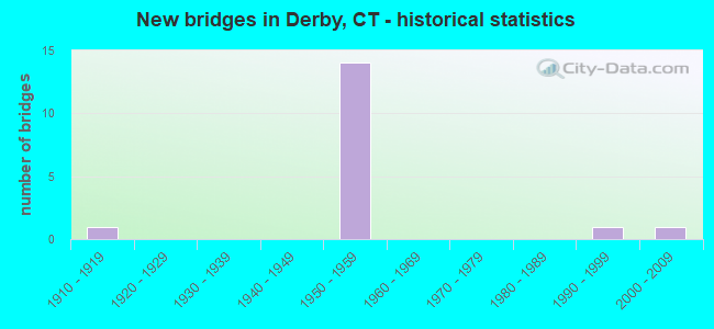
- New bridges - historical statistics
- 11910-1919
- 141950-1959
- 11990-1999
- 12000-2009

- Reconstructed bridges - Historical Statistics
- 21980-1989
- 31990-1999
- 12000-2009
- 12010-2019


- Bridge Condition - Deck
- 33.3%Good
- 33.3%Satisfactory
- 33.3%Fair

- Bridge Condition - Superstructure
- 30.0%Good
- 60.0%Satisfactory
- 10.0%Fair

- Bridge Condition - Substructure
- 40.0%Good
- 60.0%Satisfactory

- Bridge Condition - Channel
- 25.0%Good
- 50.0%Satisfactory
- 25.0%Fair
Find on map >> Show street view
Structure Number: 572, Location: AT EXIT 15 (Lat: 41.317431, Lng: -73.084686), Route carried "on" structure: State highway 8, Year Built: 1950, Year Reconstructed: 1988, Status: Open, Structure Length: 4.08m (13.39ft), Average Daily Traffic: 74,000 (year 2018), Truck Traffic: 6%, Average Future Daily Traffic: 109,957 (year 2038), Design Load: HS 20, Features Intersected: HOUSATONIC RAILROAD
Minimum Vertical Clearance: 30+ m (98+ ft), Kilometerpoint: 20.374, Lanes on structure: 6, Base Highway Network: Yes, Owner: State Highway Agency, Approaching Roadway Width: 34.1m (111.9ft), Skew: 31 degrees, Material/Design: Steel, Design/Construction: Stringer/Multi-beam, Number Of Spans In Main Unit: 3, Length of Maximum Span: 19.2m (63.0ft), Curb or Sidewalk Widths: Left: 1.5m (4.9ft), Right: 0.0m, Curb-To-Curb Width: 34.1m (111.9ft), Out-to-Out Width: 37.7m (123.7ft)
Condition: Deck: Fair, Superstructure: Fair, Substructure: Satisfactory, Operating Rating: 86.3 metric tons, Method Used To Determine Operating Rating: Load Factor (LF), Inventory Rating: 51.8 metric tons, Method Used To Determine Inventory Rating: Load Factor (LF), Structural Evaluation: Somewhat better than minimum adequacy, Deck Geometry: Superior to present desirable criteria, Underclear: High priority of corrective action, Approach Roadway Alignment: Equal to present desirable criteria, Designated Inspection Frequency: Every 24 months, Inspection Date: May 2021, Deck Structure Type: Concrete Cast-file-Place, Wearing Surface/Protective System: Wearing Surface: Bituminous, Membrane: Preformed Fabric, Deck Protection: Epoxy Coated Reinforcing
Find on map >> Show street view
Structure Number: 573A, Location: ROUTE 8, EXIT 15 (Lat: 41.319697, Lng: -73.084236), Route carried "on" structure: State highway 8, Year Built: 1951, Year Reconstructed: 1998, Status: Open, Structure Length: 11.64m (38.19ft), Average Daily Traffic: 73,300 (year 2018), Truck Traffic: 8%, Average Future Daily Traffic: 108,916 (year 2038), Design Load: HS 20, Features Intersected: ROUTE 34 & RR Drive
Minimum Vertical Clearance: 30+ m (98+ ft), Kilometerpoint: 20.616, Lanes on structure: 6, Lanes under structure: 9, Base Highway Network: Yes, Owner: State Highway Agency, Approaching Roadway Width: 29.9m (98.1ft), Skew: 30 degrees, Material/Design: Steel continuous, Design/Construction: Stringer/Multi-beam, Number Of Spans In Main Unit: 2, Length of Maximum Span: 57.9m (190.0ft), Curb-To-Curb Width: 29.9m (98.1ft), Out-to-Out Width: 32.6m (107.0ft)
Condition: Deck: Satisfactory, Superstructure: Satisfactory, Substructure: Good, Operating Rating: 66.0 metric tons, Method Used To Determine Operating Rating: Load Factor (LF), Inventory Rating: 39.6 metric tons, Method Used To Determine Inventory Rating: Load Factor (LF), Structural Evaluation: Equal to present minimum criteria, Deck Geometry: Superior to present desirable criteria, Underclear: High priority of corrective action, Approach Roadway Alignment: Equal to present minimum criteria, Designated Inspection Frequency: Every 24 months, Inspection Date: Febuary 2020, Deck Structure Type: Concrete Cast-file-Place, Wearing Surface/Protective System: Wearing Surface: Bituminous, Membrane: Built-up, Deck Protection: Epoxy Coated Reinforcing
Find on map >> Show street view
Structure Number: 573B, Location: ROUTE 8, EXIT 15 (Lat: 41.319786, Lng: -73.083758), Route carried "on" structure: Ramp State highway 8, Year Built: 1996, Status: Open, Structure Length: 12.83m (42.09ft), Average Daily Traffic: 8,500 (year 2018), Truck Traffic: 8%, Average Future Daily Traffic: 12,630 (year 2038), Design Load: HS 20, Features Intersected: METRO-NORTH & RR DRIVE
Minimum Vertical Clearance: 30+ m (98+ ft), Kilometerpoint: 20.889, Lanes on structure: 1, Lanes under structure: 2, Owner: State Highway Agency, Approaching Roadway Width: 7.3m (24.0ft), Material/Design: Steel continuous, Design/Construction: Stringer/Multi-beam, Number Of Spans In Main Unit: 2, Length of Maximum Span: 64.9m (212.9ft), Curb-To-Curb Width: 7.3m (24.0ft), Out-to-Out Width: 8.5m (27.9ft)
Condition: Deck: Good, Superstructure: Good, Substructure: Good, Operating Rating: 66.4 metric tons, Method Used To Determine Operating Rating: Load Factor (LF), Inventory Rating: 39.8 metric tons, Method Used To Determine Inventory Rating: Load Factor (LF), Structural Evaluation: Better than present minimum criteria, Deck Geometry: Better than present minimum criteria, Underclear: Meets minimum limits, Approach Roadway Alignment: Equal to present minimum criteria, Designated Inspection Frequency: Every 24 months, Inspection Date: May 2021, Deck Structure Type: Concrete Cast-file-Place, Wearing Surface/Protective System: Wearing Surface: Bituminous, Membrane: Built-up, Deck Protection: Epoxy Coated Reinforcing
Find on map >> Show street view
Structure Number: 576, Location: 0.9 MI N OF ROUTE 34 (Lat: 41.330269, Lng: -73.089342), Route carried "on" structure: City street , Year Built: 1952, Year Reconstructed: 1991, Status: Open, Structure Length: 4.11m (13.48ft), Average Daily Traffic: 9,096 (year 2020), Truck Traffic: 5%, Average Future Daily Traffic: 13,516 (year 2040), Design Load: HS 20, Features Intersected: ROUTE 8, Facility Carried by Structure: SEYMOUR AVENUE
Minimum Vertical Clearance: 30+ m (98+ ft), Kilometerpoint: 0.644, Lanes on structure: 2, Lanes under structure: 4, Owner: State Highway Agency, Approaching Roadway Width: 11.0m (36.1ft), Skew: 4 degrees, Material/Design: Steel, Design/Construction: Stringer/Multi-beam, Number Of Spans In Main Unit: 2, Length of Maximum Span: 19.2m (63.0ft), Curb or Sidewalk Widths: Left: 2.8m (9.2ft), Right: 2.8m (9.2ft), Curb-To-Curb Width: 11.0m (36.1ft), Out-to-Out Width: 17.9m (58.7ft)
Condition: Deck: Fair, Superstructure: Satisfactory, Substructure: Satisfactory, Operating Rating: 89.8 metric tons, Method Used To Determine Operating Rating: Load Factor (LF), Inventory Rating: 70.7 metric tons, Method Used To Determine Inventory Rating: Load Factor (LF), Structural Evaluation: Equal to present minimum criteria, Deck Geometry: Meets minimum limits, Underclear: High priority of corrective action, Approach Roadway Alignment: Equal to present desirable criteria, Designated Inspection Frequency: Every 24 months, Inspection Date: March 2020, Deck Structure Type: Concrete Cast-file-Place, Wearing Surface/Protective System: Wearing Surface: Bituminous, Membrane: Preformed Fabric, Deck Protection: Epoxy Coated Reinforcing
Find on map >> Show street view
Structure Number: 577, Location: 0.9 MILES NORTH ROUTE 34 (Lat: 41.331119, Lng: -73.090617), Route carried "on" structure: City street , Year Built: 1952, Year Reconstructed: 2001, Status: Open, Structure Length: 5.64m (18.50ft), Average Daily Traffic: 3,297 (year 2019), Truck Traffic: 4%, Average Future Daily Traffic: 4,899 (year 2039), Design Load: HS 20, Features Intersected: ROUTE 8, Facility Carried by Structure: HAWKINS STREET
Minimum Vertical Clearance: 30+ m (98+ ft), Kilometerpoint: 0.805, Lanes on structure: 2, Lanes under structure: 5, Owner: State Highway Agency, Approaching Roadway Width: 9.1m (29.9ft), Skew: 2 degrees, Material/Design: Steel continuous, Design/Construction: Stringer/Multi-beam, Number Of Spans In Main Unit: 2, Length of Maximum Span: 27.4m (89.9ft), Curb or Sidewalk Widths: Left: 2.1m (6.9ft), Right: 2.1m (6.9ft), Curb-To-Curb Width: 9.1m (29.9ft), Out-to-Out Width: 14.2m (46.6ft)
Condition: Deck: Satisfactory, Superstructure: Good, Substructure: Good, Operating Rating: 64.2 metric tons, Method Used To Determine Operating Rating: Load and Resistance Factor Rating (LRFR) rating reported by rating factor(RF) method using HL-93 loadings, Inventory Rating: 49.6 metric tons, Method Used To Determine Inventory Rating: Load and Resistance Factor Rating (LRFR) rating reported by rating factor(RF) method using HL-93 loadings, Structural Evaluation: Better than present minimum criteria, Deck Geometry: Meets minimum limits, Underclear: High priority of corrective action, Approach Roadway Alignment: Equal to present minimum criteria, Designated Inspection Frequency: Every 24 months, Inspection Date: March 2020, Deck Structure Type: Concrete Cast-file-Place, Wearing Surface/Protective System: Wearing Surface: Bituminous, Membrane: Built-up, Deck Protection: Epoxy Coated Reinforcing
Find on map >> Show street view
Structure Number: 578, Location: 1.3 MI N OF ROUTE 34 (Lat: 41.336519, Lng: -73.092231), Route carried "on" structure: City street , Year Built: 1959, Status: Open, Structure Length: 3.57m (11.71ft), Average Daily Traffic: 473 (year 2019), Truck Traffic: 4%, Average Future Daily Traffic: 703 (year 2039), Design Load: HS 20, Features Intersected: ROUTE 8, Facility Carried by Structure: BLUFF STREET
Minimum Vertical Clearance: 30+ m (98+ ft), Kilometerpoint: 0.000, Lanes on structure: 2, Lanes under structure: 5, Owner: State Highway Agency, Approaching Roadway Width: 12.2m (40.0ft), Material/Design: Steel, Design/Construction: Stringer/Multi-beam, Number Of Spans In Main Unit: 2, Length of Maximum Span: 17.1m (56.1ft), Curb or Sidewalk Widths: Left: 0.5m (1.6ft), Right: 1.5m (4.9ft), Curb-To-Curb Width: 12.2m (40.0ft), Out-to-Out Width: 15.0m (49.2ft)
Condition: Deck: Fair, Superstructure: Satisfactory, Substructure: Satisfactory, Operating Rating: 42.4 metric tons, Method Used To Determine Operating Rating: Load and Resistance Factor Rating (LRFR) rating reported by rating factor(RF) method using HL-93 loadings, Inventory Rating: 32.7 metric tons, Method Used To Determine Inventory Rating: Load and Resistance Factor Rating (LRFR) rating reported by rating factor(RF) method using HL-93 loadings, Structural Evaluation: Equal to present minimum criteria, Deck Geometry: Equal to present desirable criteria, Underclear: High priority of corrective action, Approach Roadway Alignment: Equal to present minimum criteria, Designated Inspection Frequency: Every 24 months, Inspection Date: March 2020, Deck Structure Type: Concrete Cast-file-Place, Wearing Surface/Protective System: Wearing Surface: Monolithic Concrete
Find on map >> Show street view
Structure Number: 946, Location: 0.1 MI E OF ROUTE 8 (Lat: 41.319239, Lng: -73.083419), Route carried "on" structure: State highway 34, Year Built: 1951, Year Reconstructed: 1996, Status: Open, Structure Length: 1.34m (4.40ft), Average Daily Traffic: 42,200 (year 2018), Truck Traffic: 6%, Average Future Daily Traffic: 62,705 (year 2038), Design Load: HS 20, Features Intersected: METRO NORTH RAILROAD
Minimum Vertical Clearance: 30+ m (98+ ft), Kilometerpoint: 22.724, Lanes on structure: 5, Base Highway Network: Yes, Owner: State Highway Agency, Approaching Roadway Width: 23.2m (76.1ft), Skew: 22 degrees, Material/Design: Steel, Design/Construction: Stringer/Multi-beam, Number Of Spans In Main Unit: 1, Length of Maximum Span: 12.5m (41.0ft), Curb or Sidewalk Widths: Left: 1.7m (5.6ft), Right: 0.0m, Curb-To-Curb Width: 23.3m (76.4ft), Out-to-Out Width: 28.7m (94.2ft)
Condition: Deck: Satisfactory, Superstructure: Satisfactory, Substructure: Satisfactory, Inventory Rating: 81.4 metric tons, Method Used To Determine Inventory Rating: Load Factor (LF), Structural Evaluation: Equal to present minimum criteria, Deck Geometry: Better than present minimum criteria, Underclear: High priority of corrective action, Approach Roadway Alignment: Better than present minimum criteria, Designated Inspection Frequency: Every 24 months, Inspection Date: June 2021, Deck Structure Type: Concrete Cast-file-Place, Wearing Surface/Protective System: Wearing Surface: Bituminous, Membrane: Preformed Fabric, Deck Protection: Epoxy Coated Reinforcing
Find on map >> Show street view
Structure Number: 947, Location: 0.1 MI E OF ROUTE 8 (Lat: 41.318911, Lng: -73.082047), Route carried "on" structure: State highway 34, Year Built: 1959, Year Reconstructed: 2017, Status: Open, Structure Length: 10.05m (32.97ft), Average Daily Traffic: 42,300 (year 2015), Truck Traffic: 6%, Average Future Daily Traffic: 62,854 (year 2035), Design Load: HS 20, Features Intersected: NAUGATUCK RIVER
Minimum Vertical Clearance: 30+ m (98+ ft), Kilometerpoint: 22.804, Lanes on structure: 6, Base Highway Network: Yes, Owner: State Highway Agency, Approaching Roadway Width: 23.8m (78.1ft), Skew: 22 degrees, Material/Design: Steel, Design/Construction: Stringer/Multi-beam, Number Of Spans In Main Unit: 3, Length of Maximum Span: 32.6m (107.0ft), Curb or Sidewalk Widths: Left: 1.7m (5.6ft), Right: 0.0m, Curb-To-Curb Width: 23.8m (78.1ft), Out-to-Out Width: 28.1m (92.2ft)
Condition: Deck: Good, Superstructure: Satisfactory, Substructure: Satisfactory, Channel: Fair, Operating Rating: 52.8 metric tons, Method Used To Determine Operating Rating: Load and Resistance Factor Rating (LRFR) rating reported by rating factor(RF) method using HL-93 loadings, Inventory Rating: 40.8 metric tons, Method Used To Determine Inventory Rating: Load and Resistance Factor Rating (LRFR) rating reported by rating factor(RF) method using HL-93 loadings, Structural Evaluation: Equal to present minimum criteria, Deck Geometry: Somewhat better than minimum adequacy, Waterway Adequacy: Equal to present desirable criteria, Approach Roadway Alignment: Equal to present minimum criteria, Designated Inspection Frequency: Every 24 months, Inspection Date: November 2021, Deck Structure Type: Concrete Cast-file-Place, Wearing Surface/Protective System: Wearing Surface: Bituminous, Membrane: Other
Find on map >> Show street view
Structure Number: 1659, Location: 0.13 MI EAST OF RTE 110 (Lat: 41.319153, Lng: -73.091133), Route carried "on" structure: State highway 712, Year Built: 1918, Status: Open, Structure Length: 14.20m (46.59ft), Average Daily Traffic: 13,000 (year 2018), Truck Traffic: 6%, Average Future Daily Traffic: 19,317 (year 2038), Features Intersected: HOUSATONIC RIVER
Minimum Vertical Clearance: 30+ m (98+ ft), Kilometerpoint: 0.209, Lanes on structure: 2, Owner: State Highway Agency, Approaching Roadway Width: 13.1m (43.0ft), Material/Design: Concrete, Design/Construction: Arch - Deck, Number Of Spans In Main Unit: 5, Length of Maximum Span: 28.7m (94.2ft), Curb or Sidewalk Widths: Left: 3.0m (9.8ft), Right: 3.0m (9.8ft), Curb-To-Curb Width: 13.0m (42.7ft), Out-to-Out Width: 20.2m (66.3ft)
Condition: Superstructure: Satisfactory, Substructure: Satisfactory, Channel: Satisfactory, Operating Rating: 89.8 metric tons, Method Used To Determine Operating Rating: Allowable Stress (AS), Inventory Rating: 89.8 metric tons, Method Used To Determine Inventory Rating: Allowable Stress (AS), Structural Evaluation: Equal to present minimum criteria, Deck Geometry: Somewhat better than minimum adequacy, Waterway Adequacy: Equal to present desirable criteria, Approach Roadway Alignment: Better than present minimum criteria, Designated Inspection Frequency: Every 24 months, Underwater Inspection Frequency: Every 24 months, Inspection Date: May 2020, Underwater Inspection Date: Febuary 2020, Total Project Cost: $4,000,000 ( Estimate for 2016)
Find on map >> Show street view
Structure Number: 6062, Location: 0.8 MI W OF ROUTE 8 (Lat: 41.324461, Lng: -73.096800), Route carried "on" structure: State highway 34, Year Built: 1952, Year Reconstructed: 2009, Status: Open, Structure Length: 2.29m (7.51ft), Average Daily Traffic: 13,100 (year 2015), Truck Traffic: 4%, Average Future Daily Traffic: 19,465 (year 2035), Features Intersected: DERBY CANAL
Minimum Vertical Clearance: 30+ m (98+ ft), Kilometerpoint: 21.388, Lanes on structure: 2, Base Highway Network: Yes, Owner: State Highway Agency, Approaching Roadway Width: 11.0m (36.1ft), Skew: 2 degrees, Material/Design: Steel, Design/Construction: Culvert, Number Of Spans In Main Unit: 4, Length of Maximum Span: 5.2m (17.1ft)
Condition: Channel: Satisfactory, Culverts: Satisfactory, Operating Rating: 80.4 metric tons, Method Used To Determine Operating Rating: Load and Resistance Factor Rating (LRFR) rating reported by rating factor(RF) method using HL-93 loadings, Inventory Rating: 61.9 metric tons, Method Used To Determine Inventory Rating: Load and Resistance Factor Rating (LRFR) rating reported by rating factor(RF) method using HL-93 loadings, Structural Evaluation: Equal to present minimum criteria, Waterway Adequacy: Equal to present desirable criteria, Approach Roadway Alignment: Better than present minimum criteria, Designated Inspection Frequency: Every 24 months, Underwater Inspection Frequency: Every 24 months, Inspection Date: November 2021, Underwater Inspection Date: November 2021
Find on map >> Show street view
Structure Number: 6063, Location: 25' WEST OF ROUTE 34 (Lat: 41.325428, Lng: -73.098772), Route carried "on" structure: City street , Year Built: 2005, Status: Open, Structure Length: 1.46m (4.79ft), Average Daily Traffic: 292 (year 2021), Truck Traffic: 2%, Average Future Daily Traffic: 434 (year 2041), Design Load: HS 20, Features Intersected: DERBY CANAL, Facility Carried by Structure: CANAL STREET
Minimum Vertical Clearance: 30+ m (98+ ft), Kilometerpoint: 0.000, Lanes on structure: 2, Owner: City or Municipal Highway Agency, Approaching Roadway Width: 8.8m (28.9ft), Material/Design: Prestressed concrete, Design/Construction: Slab, Number Of Spans In Main Unit: 1, Length of Maximum Span: 13.4m (44.0ft), Curb or Sidewalk Widths: Left: 0.1m (0.3ft), Right: 0.1m (0.3ft), Curb-To-Curb Width: 8.8m (28.9ft), Out-to-Out Width: 9.9m (32.5ft)
Condition: Deck: Good, Superstructure: Good, Substructure: Good, Channel: Good, Operating Rating: 39.9 metric tons, Method Used To Determine Operating Rating: Load and Resistance Factor Rating (LRFR) rating reported by rating factor(RF) method using HL-93 loadings, Inventory Rating: 30.8 metric tons, Method Used To Determine Inventory Rating: Load and Resistance Factor Rating (LRFR) rating reported by rating factor(RF) method using HL-93 loadings, Structural Evaluation: Better than present minimum criteria, Deck Geometry: Equal to present minimum criteria, Waterway Adequacy: Better than present minimum criteria, Approach Roadway Alignment: Equal to present minimum criteria, Designated Inspection Frequency: Every 48 months, Underwater Inspection Frequency: Every 48 months, Inspection Date: November 2021, Underwater Inspection Date: November 2021, Deck Structure Type: Other, Wearing Surface/Protective System: Wearing Surface: Bituminous, Membrane: Built-up, Deck Protection: Epoxy Coated Reinforcing
Find on map >> Show street view
Structure Number: 573A, Location: ROUTE 8, EXIT 15 (Lat: 41.319697, Lng: -73.084236), Route carried "under" structure: State highway 34, Year Built: 1951, Structure Length: 0. m, Average Daily Traffic: 42,200 (year 2015), Truck Traffic: 6%, Features Intersected: ROUTE 34 & RR Drive, Facility Carried by Structure: ROUTE 8
Minimum Vertical Clearance: 4.72m (15.49ft), Kilometerpoint: 22.660, Lanes on structure: 6, Lanes under structure: 7, Material/Design: Steel continuous, Design/Construction: Stringer/Multi-beam, Length of Maximum Span: 57.9m (190.0ft)
Find on map >> Show street view
Structure Number: 575, Location: 0.6 MI N OF ROUTE 34 (Lat: 41.327539, Lng: -73.085942), Route carried "under" structure: State highway 727, Year Built: 1951, Structure Length: 0. m, Average Daily Traffic: 19,400 (year 2018), Truck Traffic: 6%, Features Intersected: SR 727 SB PERSHING DRIVE, Facility Carried by Structure: ROUTE 8
Minimum Vertical Clearance: 4.83m (15.85ft), Kilometerpoint: 0.306, Lanes on structure: 4, Lanes under structure: 1, Material/Design: Steel continuous, Design/Construction: Stringer/Multi-beam, Length of Maximum Span: 20.4m (66.9ft)
Find on map >> Show street view
Structure Number: 576, Location: 0.9 MI N OF ROUTE 34 (Lat: 41.330269, Lng: -73.089342), Route carried "under" structure: State highway 8, Year Built: 1952, Structure Length: 0. m, Average Daily Traffic: 62,600 (year 2018), Truck Traffic: 8%, Features Intersected: ROUTE 8, Facility Carried by Structure: SEYMOUR AVENUE
Minimum Vertical Clearance: 4.88m (16.01ft), Kilometerpoint: 22.016, Lanes on structure: 2, Lanes under structure: 4, Material/Design: Steel, Design/Construction: Stringer/Multi-beam, Length of Maximum Span: 19.2m (63.0ft)
Find on map >> Show street view
Structure Number: 577, Location: 0.9 MILES NORTH ROUTE 34 (Lat: 41.331119, Lng: -73.090617), Route carried "under" structure: Ramp State highway 8, Year Built: 1952, Structure Length: 0. m, Average Daily Traffic: 1,650 (year 2016), Truck Traffic: 8%, Features Intersected: ROUTE 8, Facility Carried by Structure: HAWKINS STREET
Minimum Vertical Clearance: 4.95m (16.24ft), Kilometerpoint: 0.000, Lanes on structure: 2, Lanes under structure: 1, Material/Design: Steel continuous, Design/Construction: Stringer/Multi-beam, Length of Maximum Span: 27.4m (89.9ft)
Find on map >> Show street view
Structure Number: 577, Location: 0.9 MILES NORTH ROUTE 34 (Lat: 41.331119, Lng: -73.090617), Route carried "under" structure: State highway 8, Year Built: 1952, Structure Length: 0. m, Average Daily Traffic: 62,600 (year 2018), Truck Traffic: 8%, Features Intersected: ROUTE 8, Facility Carried by Structure: HAWKINS STREET
Minimum Vertical Clearance: 5.21m (17.09ft), Lanes on structure: 2, Lanes under structure: 4, Material/Design: Steel continuous, Design/Construction: Stringer/Multi-beam, Length of Maximum Span: 27.4m (89.9ft)
Find on map >> Show street view
Structure Number: 578, Location: 1.3 MI N OF ROUTE 34 (Lat: 41.336519, Lng: -73.092231), Route carried "under" structure: State highway 8, Year Built: 1959, Structure Length: 0. m, Average Daily Traffic: 65,000 (year 2018), Truck Traffic: 8%, Features Intersected: ROUTE 8, Facility Carried by Structure: BLUFF STREET
Minimum Vertical Clearance: 5.39m (17.68ft), Kilometerpoint: 22.772, Lanes on structure: 2, Lanes under structure: 4, Material/Design: Steel, Design/Construction: Stringer/Multi-beam, Length of Maximum Span: 17.1m (56.1ft)