Bridge Statistics for Carbondale, Pennsylvania (PA)
Condition, Traffic, Stress, Structural Evaluation, Project Costs
- National Bridge Inventory (NBI) Statistics
- 23Number of bridges
- 167ft / 50.6mTotal length
- $3,177,000Total costs
- 95,644Total average daily traffic
- 5,090Total average daily truck traffic
- National Bridge Inventory (NBI) Registered Bridges for Carbondale
- No street view available for this location
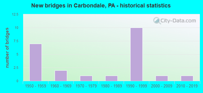
- New bridges - historical statistics
- 71950-1959
- 21960-1969
- 11970-1979
- 11980-1989
- 101990-1999
- 12000-2009
- 12010-2019

- Reconstructed bridges - Historical Statistics
- 11980-1989
- 01990-1999
- 22000-2009


- Bridge Condition - Deck
- 42.9%Good
- 35.7%Satisfactory
- 21.4%Poor

- Bridge Condition - Superstructure
- 20.0%Very good
- 26.7%Good
- 13.3%Satisfactory
- 13.3%Fair
- 13.3%Poor
- 6.7%Serious
- 6.7%Failed

- Bridge Condition - Substructure
- 46.7%Good
- 13.3%Satisfactory
- 20.0%Fair
- 20.0%Poor

- Bridge Condition - Channel
- 7.1%Very good
- 21.4%Good
- 42.9%Satisfactory
- 21.4%Fair
- 7.1%Poor

- Bridge Condition - Culverts
- 50.0%Very good
- 50.0%Satisfactory
Find on map >> Show street view
Structure Number: 20398, Location: CARBONDALE CTY .3M E 6006 (Lat: 41.563383, Lng: -75.517792), Route carried "on" structure: Business State highway , Year Built: 1963, Status: Open, Structure Length: 3.02m (9.91ft), Average Daily Traffic: 1,374 (year 2020), Truck Traffic: 3%, Average Future Daily Traffic: 3,946 (year 2032), Design Load: HS 20, Features Intersected: LACKAWANNA RIVER, Facility Carried by Structure: SR 1041 OLD RTE 6
Minimum Vertical Clearance: 30+ m (98+ ft), Kilometerpoint: 0.249, Lanes on structure: 2, Base Highway Network: Yes, Owner: State Highway Agency, Approaching Roadway Width: 10.4m (34.1ft), Skew: 2 degrees, Material/Design: Prestressed concrete, Design/Construction: Box Beam or Girders - Single/Spread, Number Of Spans In Main Unit: 2, Length of Maximum Span: 14.6m (47.9ft), Curb or Sidewalk Widths: Left: 1.5m (4.9ft), Right: 1.5m (4.9ft), Curb-To-Curb Width: 10.4m (34.1ft), Out-to-Out Width: 14.2m (46.6ft)
Condition: Deck: Satisfactory, Superstructure: Satisfactory, Substructure: Fair, Channel: Poor, Operating Rating: 86.2 metric tons, Method Used To Determine Operating Rating: Load Factor (LF), Inventory Rating: 50.8 metric tons, Method Used To Determine Inventory Rating: Load Factor (LF), Structural Evaluation: Somewhat better than minimum adequacy, Deck Geometry: Equal to present minimum criteria, Waterway Adequacy: Equal to present minimum criteria, Approach Roadway Alignment: Better than present minimum criteria, Length Of Structure Improvement: 4.00m (13.12ft), Designated Inspection Frequency: Every 24 months, Inspection Date: July 2020, Deck Structure Type: Concrete Cast-file-Place, Wearing Surface/Protective System: Wearing Surface: Bituminous
Find on map >> Show street view
Structure Number: 20399, Location: CARBONDALE 200' W TR 171 (Lat: 41.575350, Lng: -75.498417), Route carried "on" structure: Business US 6B, Year Built: 1963, Status: Open, Structure Length: 1.25m (4.10ft), Average Daily Traffic: 8,372 (year 2021), Truck Traffic: 4%, Average Future Daily Traffic: 11,177 (year 2032), Design Load: HS 20, Features Intersected: RACKET BROOK, Facility Carried by Structure: SR 6006 BUSINESS 6
Minimum Vertical Clearance: 30+ m (98+ ft), Kilometerpoint: 20.017, Lanes on structure: 2, Base Highway Network: Yes, Owner: State Highway Agency, Approaching Roadway Width: 10.4m (34.1ft), Skew: 4 degrees, Material/Design: Steel, Design/Construction: Stringer/Multi-beam, Number Of Spans In Main Unit: 1, Length of Maximum Span: 12.2m (40.0ft), Curb or Sidewalk Widths: Left: 1.5m (4.9ft), Right: 1.5m (4.9ft), Curb-To-Curb Width: 10.4m (34.1ft), Out-to-Out Width: 14.2m (46.6ft)
Condition: Deck: Satisfactory, Superstructure: Fair, Substructure: Poor, Channel: Satisfactory, Operating Rating: 61.7 metric tons, Method Used To Determine Operating Rating: Load Factor (LF), Inventory Rating: 37.2 metric tons, Method Used To Determine Inventory Rating: Load Factor (LF), Structural Evaluation: Meets minimum limits, Deck Geometry: Meets minimum limits, Waterway Adequacy: Equal to present minimum criteria, Approach Roadway Alignment: Better than present minimum criteria, Length Of Structure Improvement: 1.20m (3.94ft), Designated Inspection Frequency: Every 24 months, Inspection Date: July 2020, Bridge Improvement Cost: $12,000, Roadway Improvement Cost: $100,000, Total Project Cost: $162,000, Deck Structure Type: Concrete Cast-file-Place, Wearing Surface/Protective System: Wearing Surface: Bituminous
Find on map >> Show street view
Structure Number: 20516, Location: FELL TWP 1 M W SR 1007 (Lat: 41.595556, Lng: -75.519722), Route carried "on" structure: State highway 106, Year Built: 1959, Status: Open, Structure Length: 1.74m (5.71ft), Average Daily Traffic: 3,196 (year 2020), Truck Traffic: 5%, Average Future Daily Traffic: 6,153 (year 2032), Design Load: HS 20, Features Intersected: FALL BROOK
Minimum Vertical Clearance: 30+ m (98+ ft), Kilometerpoint: 10.025, Lanes on structure: 2, Base Highway Network: Yes, Owner: State Highway Agency, Approaching Roadway Width: 8.5m (27.9ft), Skew: 6 degrees, Material/Design: Concrete, Design/Construction: Culvert, Number Of Spans In Main Unit: 1, Length of Maximum Span: 17.4m (57.1ft)
Condition: Channel: Fair, Culverts: Satisfactory, Operating Rating: 49.0 metric tons, Method Used To Determine Operating Rating: Field evaluation and documented engineering judgment, Inventory Rating: 32.7 metric tons, Method Used To Determine Inventory Rating: Field evaluation and documented engineering judgment, Structural Evaluation: Equal to present minimum criteria, Waterway Adequacy: Superior to present desirable criteria, Approach Roadway Alignment: Equal to present desirable criteria, Length Of Structure Improvement: 1.70m (5.58ft), Designated Inspection Frequency: Every 24 months, Inspection Date: June 2020, Bridge Improvement Cost: $30,000, Roadway Improvement Cost: $100,000, Total Project Cost: $402,000
Find on map >> Show street view
Structure Number: 20517, Location: FELL TWP .8 M S SR 1009 (Lat: 41.592803, Lng: -75.517769), Route carried "on" structure: State highway 106, Year Built: 1959, Year Reconstructed: 2007, Status: Open, Structure Length: 1.58m (5.18ft), Average Daily Traffic: 3,166 (year 2022), Truck Traffic: 7%, Average Future Daily Traffic: 4,257 (year 2032), Design Load: HS 20, Features Intersected: FALL BROOK
Minimum Vertical Clearance: 30+ m (98+ ft), Kilometerpoint: 9.244, Lanes on structure: 2, Base Highway Network: Yes, Owner: State Highway Agency, Approaching Roadway Width: 11.6m (38.1ft), Skew: 4 degrees, Material/Design: Prestressed concrete, Design/Construction: Box Beam or Girders - Single/Spread, Number Of Spans In Main Unit: 1, Length of Maximum Span: 15.2m (49.9ft), Curb-To-Curb Width: 12.0m (39.4ft), Out-to-Out Width: 13.1m (43.0ft)
Condition: Deck: Good, Superstructure: Very good, Substructure: Good, Channel: Satisfactory, Operating Rating: 91.6 metric tons, Method Used To Determine Operating Rating: Load Factor (LF), Inventory Rating: 35.4 metric tons, Method Used To Determine Inventory Rating: Load Factor (LF), Structural Evaluation: Better than present minimum criteria, Deck Geometry: Somewhat better than minimum adequacy, Waterway Adequacy: Equal to present minimum criteria, Approach Roadway Alignment: Equal to present desirable criteria, Length Of Structure Improvement: 1.60m (5.25ft), Designated Inspection Frequency: Every 24 months, Inspection Date: June 2020, Bridge Improvement Cost: $23,000, Roadway Improvement Cost: $100,000, Total Project Cost: $307,000, Wearing Surface/Protective System: Wearing Surface: Monolithic Concrete, Deck Protection: Epoxy Coated Reinforcing
Find on map >> Show street view
Structure Number: 20518, Location: FELL TWP .5 M S SR 1009 (Lat: 41.595856, Lng: -75.519247), Route carried "on" structure: State highway 106, Year Built: 1959, Year Reconstructed: 2007, Status: Open, Structure Length: 1.83m (6.00ft), Average Daily Traffic: 3,166 (year 2022), Truck Traffic: 7%, Average Future Daily Traffic: 4,257 (year 2032), Design Load: HS 20, Features Intersected: FALL BROOK
Minimum Vertical Clearance: 30+ m (98+ ft), Kilometerpoint: 9.244, Lanes on structure: 2, Base Highway Network: Yes, Owner: State Highway Agency, Approaching Roadway Width: 11.3m (37.1ft), Skew: 3 degrees, Material/Design: Prestressed concrete, Design/Construction: Box Beam or Girders - Single/Spread, Number Of Spans In Main Unit: 1, Length of Maximum Span: 17.7m (58.1ft), Curb or Sidewalk Widths: Left: 0.2m (0.7ft), Right: 0.2m (0.7ft), Curb-To-Curb Width: 11.6m (38.1ft), Out-to-Out Width: 12.9m (42.3ft)
Condition: Deck: Good, Superstructure: Very good, Substructure: Good, Channel: Satisfactory, Operating Rating: 83.5 metric tons, Method Used To Determine Operating Rating: Load Factor (LF), Inventory Rating: 39.9 metric tons, Method Used To Determine Inventory Rating: Load Factor (LF), Structural Evaluation: Better than present minimum criteria, Deck Geometry: Somewhat better than minimum adequacy, Waterway Adequacy: Equal to present desirable criteria, Approach Roadway Alignment: Better than present minimum criteria, Length Of Structure Improvement: 1.90m (6.23ft), Designated Inspection Frequency: Every 24 months, Inspection Date: July 2020, Bridge Improvement Cost: $45,000, Roadway Improvement Cost: $131,000, Total Project Cost: $602,000, Deck Structure Type: Concrete Cast-file-Place, Wearing Surface/Protective System: Wearing Surface: Monolithic Concrete, Deck Protection: Epoxy Coated Reinforcing
Find on map >> Show street view
Structure Number: 20519, Location: FELL TWP .1 M E SR 1017 (Lat: 41.598964, Lng: -75.541028), Route carried "on" structure: State highway 106, Year Built: 1959, Status: Open, Structure Length: 0.73m (2.40ft), Average Daily Traffic: 3,166 (year 2022), Truck Traffic: 7%, Average Future Daily Traffic: 4,257 (year 2032), Design Load: HS 20, Features Intersected: BRANCH OF FALL BROOK
Minimum Vertical Clearance: 30+ m (98+ ft), Kilometerpoint: 6.956, Lanes on structure: 2, Base Highway Network: Yes, Owner: State Highway Agency, Approaching Roadway Width: 8.8m (28.9ft), Skew: 1 degrees, Material/Design: Concrete, Design/Construction: Slab, Number Of Spans In Main Unit: 1, Length of Maximum Span: 6.7m (22.0ft), Curb or Sidewalk Widths: Left: 0.2m (0.7ft), Right: 0.2m (0.7ft), Curb-To-Curb Width: 11.6m (38.1ft), Out-to-Out Width: 12.6m (41.3ft)
Condition: Deck: Satisfactory, Superstructure: Satisfactory, Substructure: Satisfactory, Channel: Satisfactory, Operating Rating: 75.3 metric tons, Method Used To Determine Operating Rating: Load Factor (LF), Inventory Rating: 45.4 metric tons, Method Used To Determine Inventory Rating: Load Factor (LF), Structural Evaluation: Equal to present minimum criteria, Deck Geometry: Somewhat better than minimum adequacy, Waterway Adequacy: Equal to present minimum criteria, Approach Roadway Alignment: Equal to present desirable criteria, Length Of Structure Improvement: 0.70m (2.30ft), Designated Inspection Frequency: Every 24 months, Inspection Date: June 2020, Bridge Improvement Cost: $11,000, Roadway Improvement Cost: $100,000, Total Project Cost: $149,000, Wearing Surface/Protective System: Wearing Surface: Bituminous
Find on map >> Show street view
Structure Number: 20701, Location: CRBNDALE CTY 1M W SR 1041 (Lat: 41.568556, Lng: -75.510092), Route carried "on" structure: US 6B, Year Built: 1984, Year Reconstructed: 1992, Status: Open, Structure Length: 1.16m (3.81ft), Average Daily Traffic: 12,872 (year 2020), Truck Traffic: 4%, Average Future Daily Traffic: 18,583 (year 2032), Design Load: HS 20, Features Intersected: FALL BROOK, Facility Carried by Structure: SR 6006
Minimum Vertical Clearance: 30+ m (98+ ft), Kilometerpoint: 18.430, Lanes on structure: 3, Base Highway Network: Yes, Owner: State Highway Agency, Approaching Roadway Width: 11.3m (37.1ft), Skew: 3 degrees, Material/Design: Prestressed concrete, Design/Construction: Box Beam or Girders - Single/Spread, Number Of Spans In Main Unit: 1, Length of Maximum Span: 11.3m (37.1ft), Curb or Sidewalk Widths: Left: 1.5m (4.9ft), Right: 0.2m (0.7ft), Curb-To-Curb Width: 11.2m (36.7ft), Out-to-Out Width: 14.3m (46.9ft)
Condition: Deck: Satisfactory, Superstructure: Fair, Substructure: Satisfactory, Channel: Good, Operating Rating: 90.7 metric tons, Method Used To Determine Operating Rating: Load Factor (LF), Inventory Rating: 54.4 metric tons, Method Used To Determine Inventory Rating: Load Factor (LF), Structural Evaluation: Somewhat better than minimum adequacy, Deck Geometry: High priority of replacement, Waterway Adequacy: Equal to present minimum criteria, Approach Roadway Alignment: Equal to present desirable criteria, Length Of Structure Improvement: 1.80m (5.91ft), Designated Inspection Frequency: Every 24 months, Inspection Date: June 2020, Deck Structure Type: Concrete Cast-file-Place, Wearing Surface/Protective System: Wearing Surface: Monolithic Concrete, Deck Protection: Epoxy Coated Reinforcing
Find on map >> Show street view
Structure Number: 20703, Location: CARBONDALE TWP .3M S BUS6 (Lat: 41.580000, Lng: -75.533333), Route carried "on" structure: State highway , Year Built: 1995, Status: Open, Structure Length: 10.24m (33.60ft), Average Daily Traffic: 7,266 (year 2022), Truck Traffic: 7%, Average Future Daily Traffic: 9,833 (year 2032), Design Load: HS 25 or greater, Features Intersected: LACKA CO RAIL AUTHORITY, Facility Carried by Structure: SR 1039
Minimum Vertical Clearance: 30+ m (98+ ft), Kilometerpoint: 0.999, Lanes on structure: 3, Lanes under structure: 4, Owner: State Highway Agency, Approaching Roadway Width: 17.1m (56.1ft), Skew: 1 degrees, Material/Design: Prestressed concrete continuous, Design/Construction: Stringer/Multi-beam, Number Of Spans In Main Unit: 3, Length of Maximum Span: 36.6m (120.1ft), Curb or Sidewalk Widths: Left: 0.2m (0.7ft), Right: 0.2m (0.7ft), Curb-To-Curb Width: 17.1m (56.1ft), Out-to-Out Width: 18.2m (59.7ft)
Condition: Deck: Good, Superstructure: Good, Substructure: Good, Operating Rating: 87.1 metric tons, Method Used To Determine Operating Rating: Load Factor (LF), Inventory Rating: 34.5 metric tons, Method Used To Determine Inventory Rating: Load Factor (LF), Structural Evaluation: Better than present minimum criteria, Deck Geometry: Superior to present desirable criteria, Underclear: Meets minimum limits, Approach Roadway Alignment: Equal to present desirable criteria, Length Of Structure Improvement: 11.20m (36.75ft), Designated Inspection Frequency: Every 24 months, Inspection Date: May 2020, Deck Structure Type: Concrete Cast-file-Place, Wearing Surface/Protective System: Wearing Surface: Monolithic Concrete, Deck Protection: Epoxy Coated Reinforcing
Find on map >> Show street view
Structure Number: 20864, Location: 0.1 MI N. SR. 106 (Lat: 41.600044, Lng: -75.538050), Route carried "on" structure: City street , Year Built: 1956, Status: Open, Structure Length: 1.01m (3.31ft), Average Daily Traffic: 20 (year 2012), Average Future Daily Traffic: 30 (year 2032), Design Load: HS 20, Features Intersected: FALL BROOK, Facility Carried by Structure: BROOK VALLEY FARM
Minimum Vertical Clearance: 30+ m (98+ ft), Kilometerpoint: 0.000, Lanes on structure: 2, Owner: County Highway Agency, Approaching Roadway Width: 4.9m (16.1ft), Skew: 4 degrees, Material/Design: Prestressed concrete, Design/Construction: Box Beam or Girders - Multiple, Number Of Spans In Main Unit: 1, Length of Maximum Span: 9.1m (29.9ft), Curb or Sidewalk Widths: Left: 0.2m (0.7ft), Right: 0.2m (0.7ft), Curb-To-Curb Width: 6.9m (22.6ft), Out-to-Out Width: 7.9m (25.9ft)
Condition: Deck: Poor, Superstructure: Poor, Substructure: Poor, Channel: Fair, Operating Rating: 32.7 metric tons, Method Used To Determine Operating Rating: Field evaluation and documented engineering judgment, Inventory Rating: 19.1 metric tons, Method Used To Determine Inventory Rating: Field evaluation and documented engineering judgment, Structural Evaluation: Meets minimum limits, Deck Geometry: Somewhat better than minimum adequacy, Waterway Adequacy: Better than present minimum criteria, Approach Roadway Alignment: Equal to present desirable criteria, Length Of Structure Improvement: 1.00m (3.28ft), Designated Inspection Frequency: Every 24 months, Inspection Date: March 2020, Bridge Improvement Cost: $3,000, Roadway Improvement Cost: $9,000, Total Project Cost: $43,000, Deck Structure Type: Other, Wearing Surface/Protective System: Wearing Surface: Other
Find on map >> Show street view
Structure Number: 20882, Location: SOUTH OF BUS. RTE. 6 (Lat: 41.574617, Lng: -75.495775), Route carried "on" structure: City street , Year Built: 1950, Status: Posted for load, Structure Length: 0.85m (2.79ft), Average Daily Traffic: 70 (year 2012), Average Future Daily Traffic: 80 (year 2022), Features Intersected: RACKET BROOK, Facility Carried by Structure: SPRING STREET
Minimum Vertical Clearance: 30+ m (98+ ft), Kilometerpoint: 0.000, Lanes on structure: 2, Owner: City or Municipal Highway Agency, Approaching Roadway Width: 5.8m (19.0ft), Material/Design: Steel, Design/Construction: Stringer/Multi-beam, Number Of Spans In Main Unit: 1, Length of Maximum Span: 7.3m (24.0ft), Curb-To-Curb Width: 5.3m (17.4ft), Out-to-Out Width: 5.5m (18.0ft)
Condition: Deck: Poor, Superstructure: Poor, Substructure: Fair, Channel: Fair, Operating Rating: 6.4 metric tons, Method Used To Determine Operating Rating: Field evaluation and documented engineering judgment, Inventory Rating: 3.6 metric tons, Method Used To Determine Inventory Rating: Field evaluation and documented engineering judgment, Structural Evaluation: High priority of replacement, Deck Geometry: High priority of corrective action, Waterway Adequacy: Equal to present desirable criteria, Approach Roadway Alignment: Equal to present desirable criteria, Bridge Posting: Required (Relationship of Operating Rating to Maximum Legal Load: > 39.9% below), Length Of Structure Improvement: 0.80m (2.62ft), Designated Inspection Frequency: Every 24 months, Other Special Inspection Frequency: Every 12 months, Inspection Date: Febuary 2020, Other Special Inspection Date: Febuary 2021, Bridge Improvement Cost: $12,000, Roadway Improvement Cost: $36,000, Total Project Cost: $163,000, Wearing Surface/Protective System: Wearing Surface: Bituminous
Find on map >> Show street view
Structure Number: 20883, Location: WEST OF MAIN STREET (Lat: 41.572183, Lng: -75.503575), Route carried "on" structure: City street , Year Built: 1950, Status: Closed, Structure Length: 1.65m (5.41ft), Features Intersected: LACKAWANNA RIVER, Facility Carried by Structure: 6TH AVENUE
Minimum Vertical Clearance: 30+ m (98+ ft), Kilometerpoint: 0.000, Lanes on structure: 2, Owner: City or Municipal Highway Agency, Approaching Roadway Width: 9.4m (30.8ft), Skew: 1 degrees, Material/Design: Steel, Design/Construction: Arch - Deck, Number Of Spans In Main Unit: 1, Length of Maximum Span: 16.5m (54.1ft), Curb or Sidewalk Widths: Left: 1.8m (5.9ft), Right: 1.8m (5.9ft), Curb-To-Curb Width: 9.4m (30.8ft), Out-to-Out Width: 14.3m (46.9ft)
Condition: Superstructure: Failed, Substructure: Poor, Channel: Satisfactory, Deck Geometry: Better than present minimum criteria, Waterway Adequacy: Better than present minimum criteria, Approach Roadway Alignment: Equal to present desirable criteria, Bridge Posting: Required (Relationship of Operating Rating to Maximum Legal Load: > 39.9% below), Length Of Structure Improvement: 2.30m (7.55ft), Designated Inspection Frequency: Every 24 months, Inspection Date: Febuary 2020, Bridge Improvement Cost: $93,000, Roadway Improvement Cost: $274,000, Total Project Cost: $1,257,000
Find on map >> Show street view
Structure Number: 20884, Location: WEST OF MAIN STREET (Lat: 41.570828, Lng: -75.503681), Route carried "on" structure: City street , Year Built: 1977, Status: Posted for load, Structure Length: 1.89m (6.20ft), Average Daily Traffic: 140 (year 2002), Average Future Daily Traffic: 200 (year 2022), Design Load: HS 20, Features Intersected: LACKAWANNA RIVER, Facility Carried by Structure: 7TH AVENUE
Minimum Vertical Clearance: 30+ m (98+ ft), Kilometerpoint: 0.000, Lanes on structure: 2, Owner: City or Municipal Highway Agency, Approaching Roadway Width: 7.6m (24.9ft), Material/Design: Prestressed concrete, Design/Construction: Box Beam or Girders - Multiple, Number Of Spans In Main Unit: 1, Length of Maximum Span: 18.3m (60.0ft), Curb or Sidewalk Widths: Left: 1.5m (4.9ft), Right: 1.5m (4.9ft), Curb-To-Curb Width: 7.8m (25.6ft), Out-to-Out Width: 11.3m (37.1ft)
Condition: Deck: Poor, Superstructure: Serious, Substructure: Fair, Channel: Good, Operating Rating: 25.4 metric tons, Method Used To Determine Operating Rating: Load Factor (LF), Structural Evaluation: High priority of corrective action, Deck Geometry: Somewhat better than minimum adequacy, Waterway Adequacy: Equal to present desirable criteria, Approach Roadway Alignment: Equal to present desirable criteria, Bridge Posting: Required (Relationship of Operating Rating to Maximum Legal Load: 30.0 - 39.9% below), Length Of Structure Improvement: 1.90m (6.23ft), Designated Inspection Frequency: Every 24 months, Other Special Inspection Frequency: Every 6 months, Inspection Date: Febuary 2020, Other Special Inspection Date: Febuary 2021, Bridge Improvement Cost: $7,000, Roadway Improvement Cost: $28,000, Total Project Cost: $92,000, Deck Structure Type: Other, Wearing Surface/Protective System: Wearing Surface: Bituminous
Find on map >> Show street view
Structure Number: 39578, Location: CARBONDALE CITY OVER TR 6 (Lat: 41.558703, Lng: -75.490831), Route carried "on" structure: State highway , Year Built: 1996, Status: Open, Structure Length: 11.37m (37.30ft), Average Daily Traffic: 569 (year 2021), Truck Traffic: 7%, Average Future Daily Traffic: 816 (year 2032), Design Load: HS 25 or greater, Features Intersected: SR 0006 EB & WB, Facility Carried by Structure: SR 1019
Minimum Vertical Clearance: 30+ m (98+ ft), Kilometerpoint: 6.066, Lanes on structure: 2, Lanes under structure: 4, Owner: State Highway Agency, Approaching Roadway Width: 10.7m (35.1ft), Skew: 3 degrees, Material/Design: Prestressed concrete, Design/Construction: Stringer/Multi-beam, Number Of Spans In Main Unit: 3, Length of Maximum Span: 41.5m (136.2ft), Curb or Sidewalk Widths: Left: 0.2m (0.7ft), Right: 0.2m (0.7ft), Curb-To-Curb Width: 10.5m (34.4ft), Out-to-Out Width: 11.4m (37.4ft)
Condition: Deck: Good, Superstructure: Good, Substructure: Good, Operating Rating: 88.9 metric tons, Method Used To Determine Operating Rating: Load Factor (LF), Inventory Rating: 45.4 metric tons, Method Used To Determine Inventory Rating: Load Factor (LF), Structural Evaluation: Better than present minimum criteria, Deck Geometry: Equal to present minimum criteria, Underclear: Better than present minimum criteria, Approach Roadway Alignment: Equal to present desirable criteria, Length Of Structure Improvement: 12.40m (40.68ft), Designated Inspection Frequency: Every 24 months, Inspection Date: May 2020, Deck Structure Type: Concrete Cast-file-Place, Wearing Surface/Protective System: Wearing Surface: Monolithic Concrete, Deck Protection: Epoxy Coated Reinforcing
Find on map >> Show street view
Structure Number: 39579, Location: CARBONDALE TWP OVER TR 6 (Lat: 41.566667, Lng: -75.525000), Route carried "on" structure: State highway , Year Built: 1995, Status: Open, Structure Length: 7.50m (24.61ft), Average Daily Traffic: 7,266 (year 2022), Truck Traffic: 7%, Average Future Daily Traffic: 9,833 (year 2032), Design Load: HS 25 or greater, Features Intersected: TR 6 CASEY HIGHWAY, Facility Carried by Structure: SR1039 MEREDITH ST
Minimum Vertical Clearance: 30+ m (98+ ft), Kilometerpoint: 0.000, Lanes on structure: 2, Lanes under structure: 4, Base Highway Network: Yes, Owner: State Highway Agency, Approaching Roadway Width: 17.1m (56.1ft), Material/Design: Prestressed concrete continuous, Design/Construction: Stringer/Multi-beam, Number Of Spans In Main Unit: 2, Length of Maximum Span: 38.7m (127.0ft), Curb or Sidewalk Widths: Left: 0.2m (0.7ft), Right: 0.2m (0.7ft), Curb-To-Curb Width: 13.5m (44.3ft), Out-to-Out Width: 14.6m (47.9ft)
Condition: Deck: Good, Superstructure: Good, Substructure: Good, Inventory Rating: 55.3 metric tons, Method Used To Determine Inventory Rating: Load Factor (LF), Structural Evaluation: Better than present minimum criteria, Deck Geometry: Superior to present desirable criteria, Underclear: Better than present minimum criteria, Approach Roadway Alignment: Equal to present desirable criteria, Length Of Structure Improvement: 8.50m (27.89ft), Designated Inspection Frequency: Every 24 months, Inspection Date: May 2020, Deck Structure Type: Concrete Cast-file-Place, Wearing Surface/Protective System: Wearing Surface: Monolithic Concrete, Deck Protection: Epoxy Coated Reinforcing
Find on map >> Show street view
Structure Number: 40163, Location: CARBONDALE CITY 8TH AVE (Lat: 41.569686, Lng: -75.503803), Route carried "on" structure: US 6B, Year Built: 1998, Status: Open, Structure Length: 1.89m (6.20ft), Average Daily Traffic: 12,872 (year 2020), Truck Traffic: 4%, Average Future Daily Traffic: 18,583 (year 2032), Design Load: H 20, Features Intersected: LACKAWANNA RIVER, Facility Carried by Structure: SR 6006 EIGHTH AVE
Minimum Vertical Clearance: 30+ m (98+ ft), Kilometerpoint: 18.430, Lanes on structure: 3, Base Highway Network: Yes, Owner: State Highway Agency, Approaching Roadway Width: 11.0m (36.1ft), Material/Design: Prestressed concrete, Design/Construction: Box Beam or Girders - Multiple, Number Of Spans In Main Unit: 1, Length of Maximum Span: 18.9m (62.0ft), Curb or Sidewalk Widths: Left: 1.5m (4.9ft), Right: 1.5m (4.9ft), Curb-To-Curb Width: 11.1m (36.4ft), Out-to-Out Width: 14.8m (48.6ft)
Condition: Deck: Satisfactory, Superstructure: Good, Substructure: Good, Channel: Satisfactory, Inventory Rating: 59.0 metric tons, Method Used To Determine Inventory Rating: Load Factor (LF), Structural Evaluation: Better than present minimum criteria, Deck Geometry: High priority of replacement, Waterway Adequacy: Equal to present minimum criteria, Approach Roadway Alignment: Equal to present desirable criteria, Length Of Structure Improvement: 2.60m (8.53ft), Designated Inspection Frequency: Every 24 months, Inspection Date: June 2020, Deck Structure Type: Concrete Cast-file-Place, Wearing Surface/Protective System: Wearing Surface: Monolithic Concrete, Deck Protection: Epoxy Coated Reinforcing
Find on map >> Show street view
Structure Number: 44092, Location: CRBNDLE 360' N BUS SR6 (Lat: 41.641694, Lng: -75.592361), Route carried "on" structure: State highway 106, Year Built: 2006, Status: Open, Structure Length: 1.71m (5.61ft), Average Daily Traffic: 6,411 (year 2021), Truck Traffic: 3%, Average Future Daily Traffic: 11,259 (year 2032), Design Load: HS 25 or greater, Features Intersected: LACKAWANNA RIVER
Minimum Vertical Clearance: 30+ m (98+ ft), Kilometerpoint: 11.599, Lanes on structure: 2, Owner: State Highway Agency, Approaching Roadway Width: 11.6m (38.1ft), Skew: 2 degrees, Material/Design: Prestressed concrete, Design/Construction: Box Beam or Girders - Multiple, Number Of Spans In Main Unit: 1, Length of Maximum Span: 16.5m (54.1ft), Curb or Sidewalk Widths: Left: 1.8m (5.9ft), Right: 1.8m (5.9ft), Curb-To-Curb Width: 14.2m (46.6ft), Out-to-Out Width: 18.6m (61.0ft)
Condition: Deck: Good, Superstructure: Very good, Substructure: Good, Channel: Good, Inventory Rating: 39.9 metric tons, Method Used To Determine Inventory Rating: Load Factor (LF), Structural Evaluation: Better than present minimum criteria, Deck Geometry: Superior to present desirable criteria, Waterway Adequacy: Equal to present desirable criteria, Approach Roadway Alignment: Equal to present desirable criteria, Designated Inspection Frequency: Every 24 months, Inspection Date: June 2020, Deck Structure Type: Concrete Cast-file-Place, Wearing Surface/Protective System: Wearing Surface: Monolithic Concrete, Deck Protection: Epoxy Coated Reinforcing
Find on map >> Show street view
Structure Number: 4888, Location: FELL TWP JCT TR 106 (Lat: 41.600839, Lng: -75.522792), Route carried "on" structure: State highway , Year Built: 2014, Status: Open, Structure Length: 1.16m (3.81ft), Average Daily Traffic: 398 (year 2021), Truck Traffic: 4%, Average Future Daily Traffic: 667 (year 2035), Design Load: HL 93, Features Intersected: FALL BROOK, Facility Carried by Structure: SR 1009
Minimum Vertical Clearance: 30+ m (98+ ft), Kilometerpoint: 0.000, Lanes on structure: 2, Owner: State Highway Agency, Approaching Roadway Width: 6.7m (22.0ft), Material/Design: Concrete, Design/Construction: Culvert, Number Of Spans In Main Unit: 1, Length of Maximum Span: 11.0m (36.1ft), Curb or Sidewalk Widths: Left: 0.5m (1.6ft), Right: 0.5m (1.6ft), Curb-To-Curb Width: 5.8m (19.0ft), Out-to-Out Width: 10.1m (33.1ft)
Condition: Channel: Very good, Culverts: Very good, Operating Rating: 45.4 metric tons, Method Used To Determine Operating Rating: Assigned ratings based on Load and Resistance Factor Design (LRFD) reported by rating factor (RF) using HL93 loadings, Inventory Rating: 35.6 metric tons, Method Used To Determine Inventory Rating: Assigned ratings based on Load and Resistance Factor Design (LRFD) reported by rating factor (RF) using HL93 loadings, Structural Evaluation: Equal to present desirable criteria, Deck Geometry: High priority of corrective action, Waterway Adequacy: Superior to present desirable criteria, Approach Roadway Alignment: Equal to present desirable criteria, Designated Inspection Frequency: Every 48 months, Inspection Date: January 2021
Find on map >> Show street view
Structure Number: 20703, Location: CARBONDALE TWP .3M S BUS6 (Lat: 41.580000, Lng: -75.533333), Route carried "under" structure: City street , Year Built: 1995, Structure Length: 0. m, Average Daily Traffic: 60 (year 1996), Truck Traffic: 1%, Features Intersected: LACKA CO RAIL AUTHORITY, Facility Carried by Structure: SR 1039
Minimum Vertical Clearance: 11.25m (36.91ft), Kilometerpoint: 0.000, Lanes on structure: 3, Lanes under structure: 2, Material/Design: Prestressed concrete continuous, Design/Construction: Stringer/Multi-beam, Length of Maximum Span: 36.6m (120.1ft)
Find on map >> Show street view
Structure Number: 20703, Location: CARBONDALE TWP .3M S BUS6 (Lat: 41.580000, Lng: -75.533333), Route carried "under" structure: County highway , Year Built: 1995, Structure Length: 0. m, Average Daily Traffic: 700 (year 1996), Truck Traffic: 1%, Features Intersected: LACKA CO RAIL AUTHORITY, Facility Carried by Structure: SR 1039
Minimum Vertical Clearance: 10.57m (34.68ft), Kilometerpoint: 0.000, Lanes on structure: 3, Lanes under structure: 2, Material/Design: Prestressed concrete continuous, Design/Construction: Stringer/Multi-beam, Length of Maximum Span: 36.6m (120.1ft)
Find on map >> Show street view
Structure Number: 39578, Location: CARBONDALE CITY OVER TR 6 (Lat: 41.558703, Lng: -75.490831), Route carried "under" structure: US 6, Year Built: 1996, Structure Length: 0. m, Average Daily Traffic: 6,045 (year 2021), Truck Traffic: 6%, Features Intersected: SR 0006 EB & WB, Facility Carried by Structure: SR 1019
Minimum Vertical Clearance: 5.59m (18.34ft), Kilometerpoint: 34.461, Lanes on structure: 2, Lanes under structure: 2, Material/Design: Prestressed concrete, Design/Construction: Stringer/Multi-beam, Length of Maximum Span: 41.5m (136.2ft)
Find on map >> Show street view
Structure Number: 39578, Location: CARBONDALE CITY OVER TR 6 (Lat: 41.558703, Lng: -75.490831), Route carried "under" structure: US 6, Year Built: 1996, Structure Length: 0. m, Average Daily Traffic: 6,235 (year 2021), Truck Traffic: 7%, Features Intersected: SR 0006 EB & WB, Facility Carried by Structure: SR 1019
Minimum Vertical Clearance: 5.59m (18.34ft), Kilometerpoint: 34.575, Lanes on structure: 2, Lanes under structure: 2, Material/Design: Prestressed concrete, Design/Construction: Stringer/Multi-beam, Length of Maximum Span: 41.5m (136.2ft)
Find on map >> Show street view
Structure Number: 39579, Location: CARBONDALE TWP OVER TR 6 (Lat: 41.566667, Lng: -75.525000), Route carried "under" structure: Bypass US 6, Year Built: 1995, Structure Length: 0. m, Average Daily Traffic: 6,235 (year 2021), Truck Traffic: 7%, Features Intersected: TR 6 CASEY HIGHWAY, Facility Carried by Structure: SR1039 MEREDITH ST
Minimum Vertical Clearance: 5.23m (17.16ft), Kilometerpoint: 31.382, Lanes on structure: 2, Lanes under structure: 2, Material/Design: Prestressed concrete continuous, Design/Construction: Stringer/Multi-beam, Length of Maximum Span: 38.7m (127.0ft)
Find on map >> Show street view
Structure Number: 39579, Location: CARBONDALE TWP OVER TR 6 (Lat: 41.566667, Lng: -75.525000), Route carried "under" structure: Bypass US 6, Year Built: 1995, Structure Length: 0. m, Average Daily Traffic: 6,045 (year 2021), Truck Traffic: 6%, Features Intersected: TR 6 CASEY HIGHWAY, Facility Carried by Structure: SR1039 MEREDITH ST
Minimum Vertical Clearance: 5.23m (17.16ft), Kilometerpoint: 31.242, Lanes on structure: 2, Lanes under structure: 2, Material/Design: Prestressed concrete continuous, Design/Construction: Stringer/Multi-beam, Length of Maximum Span: 38.7m (127.0ft)