Bridge Statistics for Agawam, Massachusetts (MA)
Condition, Traffic, Stress, Structural Evaluation, Project Costs
- National Bridge Inventory (NBI) Statistics
- 16Number of bridges
- 400ft / 122mTotal length
- $131,054,000Total costs
- 598,679Total average daily traffic
- 80,732Total average daily truck traffic
- 607,179Total future (year 2031) average daily traffic
- National Bridge Inventory (NBI) Registered Bridges for Agawam
- No street view available for this location
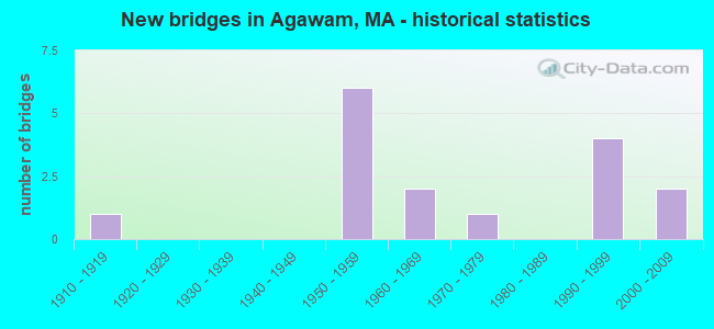
- New bridges - historical statistics
- 11910-1919
- 61950-1959
- 21960-1969
- 11970-1979
- 41990-1999
- 22000-2009

- Reconstructed bridges - Historical Statistics
- 11950-1959
- 01960-1969
- 01970-1979
- 01980-1989
- 11990-1999
- 12000-2009


- Bridge Condition - Deck
- 43.8%Good
- 25.0%Satisfactory
- 25.0%Fair
- 6.3%Poor

- Bridge Condition - Superstructure
- 37.5%Good
- 43.8%Satisfactory
- 18.8%Fair

- Bridge Condition - Substructure
- 25.0%Good
- 31.3%Satisfactory
- 43.8%Fair

- Bridge Condition - Channel
- 50.0%Good
- 25.0%Satisfactory
- 25.0%Fair
Find on map >> Show street view
Structure Number: A050010W6DOTNBI, Location: SOUTH END BRIDGE (Lat: 42.081422, Lng: -72.583153), Route carried "on" structure: US 5, Year Built: 1954, Year Reconstructed: 2006, Status: Open, Structure Length: 44.47m (145.90ft), Average Daily Traffic: 54,220 (year 2015), Truck Traffic: 10%, Average Future Daily Traffic: 79,913 (year 2031), Design Load: HS 20, Features Intersected: COMB AMTRAK & CONN RIV
Minimum Vertical Clearance: 5.31m (17.42ft), Kilometerpoint: 6.698, Lanes on structure: 4, Base Highway Network: Yes, Owner: State Highway Agency, Approaching Roadway Width: 17.1m (56.1ft), Skew: 30 degrees, Navigation Control: Yes ( Vertical Clearance: 9.7m (31.8ft), Horizontal Clearance: 83.8m (274.9ft)), Material/Design: Steel, Design/Construction: Truss - Deck, Number Of Spans In Main Unit: 7, Number Of Approach Spans: 2, Length of Maximum Span: 91.4m (299.9ft), Curb or Sidewalk Widths: Left: 1.0m (3.3ft), Right: 2.2m (7.2ft), Curb-To-Curb Width: 17.1m (56.1ft), Out-to-Out Width: 21.9m (71.9ft)
Condition: Deck: Satisfactory, Superstructure: Satisfactory, Substructure: Fair, Channel: Fair, Operating Rating: 54.3 metric tons, Method Used To Determine Operating Rating: Load Factor (LF), Inventory Rating: 32.6 metric tons, Method Used To Determine Inventory Rating: Load Factor (LF), Structural Evaluation: Somewhat better than minimum adequacy, Deck Geometry: Meets minimum limits, Underclear: Better than present minimum criteria, Waterway Adequacy: Equal to present desirable criteria, Approach Roadway Alignment: High priority of corrective action, Length Of Structure Improvement: 44.50m (146.00ft), Designated Inspection Frequency: Every 24 months, Critical Feature Inspection Frequency: Every 24 months, Underwater Inspection Frequency: Every 36 months, Inspection Date: October 2020, Critical Feature Inspection Date: October 2020, Underwater Inspection Date: August 2019, Bridge Improvement Cost: $38,281,000, Roadway Improvement Cost: $3,829,000, Total Project Cost: $57,422,000 ( Estimate for 2022), Deck Structure Type: Concrete Cast-file-Place, Wearing Surface/Protective System: Wearing Surface: Bituminous, Membrane: Built-up, Deck Protection: Epoxy Coated Reinforcing
Find on map >> Show street view
Structure Number: A050010W7DOTNBI, Location: JCT US 5 & RIVER RD. (Lat: 42.081003, Lng: -72.585539), Route carried "on" structure: US 5, Year Built: 1953, Year Reconstructed: 2003, Status: Open, Structure Length: 3.89m (12.76ft), Average Daily Traffic: 30,259 (year 2016), Truck Traffic: 10%, Average Future Daily Traffic: 93,968 (year 2031), Design Load: HS 20, Features Intersected: HWY RIVER RD
Minimum Vertical Clearance: 30+ m (98+ ft), Kilometerpoint: 7.242, Lanes on structure: 4, Lanes under structure: 2, Base Highway Network: Yes, Owner: State Highway Agency, Approaching Roadway Width: 17.1m (56.1ft), Skew: 30 degrees, Material/Design: Steel, Design/Construction: Stringer/Multi-beam, Number Of Spans In Main Unit: 2, Length of Maximum Span: 23.4m (76.8ft), Curb or Sidewalk Widths: Left: 2.0m (6.6ft), Right: 0.8m (2.6ft), Curb-To-Curb Width: 17.1m (56.1ft), Out-to-Out Width: 21.9m (71.9ft)
Condition: Deck: Satisfactory, Superstructure: Good, Substructure: Fair, Operating Rating: 72.6 metric tons, Method Used To Determine Operating Rating: Load Factor (LF), Inventory Rating: 43.5 metric tons, Method Used To Determine Inventory Rating: Load Factor (LF), Structural Evaluation: Somewhat better than minimum adequacy, Deck Geometry: High priority of corrective action, Underclear: Superior to present desirable criteria, Approach Roadway Alignment: Equal to present desirable criteria, Length Of Structure Improvement: 3.90m (12.80ft), Designated Inspection Frequency: Every 24 months, Inspection Date: July 2020, Bridge Improvement Cost: $3,355,000, Roadway Improvement Cost: $336,000, Total Project Cost: $5,033,000 ( Estimate for 2022), Deck Structure Type: Concrete Cast-file-Place, Wearing Surface/Protective System: Wearing Surface: Latex Concrete, Deck Protection: Epoxy Coated Reinforcing
Find on map >> Show street view
Structure Number: A050030KXMUNNBI, Location: BRIDGE ST AT WESTFIELD RV (Lat: 42.099381, Lng: -72.636225), Route carried "on" structure: City street , Year Built: 1970, Status: Open, Structure Length: 9.81m (32.19ft), Average Daily Traffic: 14,800 (year 2019), Truck Traffic: 6%, Average Future Daily Traffic: 16,745 (year 2032), Design Load: H 20, Features Intersected: WATER WESTFIELD RIVER, Facility Carried by Structure: HWY BRIDGE ST
Minimum Vertical Clearance: 30+ m (98+ ft), Kilometerpoint: 0.579, Lanes on structure: 2, Owner: City or Municipal Highway Agency, Approaching Roadway Width: 12.2m (40.0ft), Material/Design: Steel continuous, Design/Construction: Stringer/Multi-beam, Number Of Spans In Main Unit: 2, Length of Maximum Span: 48.8m (160.1ft), Curb or Sidewalk Widths: Left: 1.5m (4.9ft), Right: 1.5m (4.9ft), Curb-To-Curb Width: 12.2m (40.0ft), Out-to-Out Width: 16.1m (52.8ft)
Condition: Deck: Satisfactory, Superstructure: Satisfactory, Substructure: Fair, Channel: Good, Operating Rating: 56.7 metric tons, Method Used To Determine Operating Rating: Load Factor (LF), Inventory Rating: 34.0 metric tons, Method Used To Determine Inventory Rating: Load Factor (LF), Structural Evaluation: Somewhat better than minimum adequacy, Deck Geometry: Somewhat better than minimum adequacy, Waterway Adequacy: Better than present minimum criteria, Approach Roadway Alignment: Better than present minimum criteria, Length Of Structure Improvement: 9.90m (32.48ft), Designated Inspection Frequency: Every 24 months, Underwater Inspection Frequency: Every 48 months, Inspection Date: July 2021, Underwater Inspection Date: July 2020, Bridge Improvement Cost: $6,261,000, Roadway Improvement Cost: $627,000, Total Project Cost: $9,392,000 ( Estimate for 2022), Deck Structure Type: Concrete Cast-file-Place, Wearing Surface/Protective System: Wearing Surface: Bituminous, Membrane: Built-up
Find on map >> Show street view
Structure Number: A050090U1DOTNBI, Location: .75 MI N OF CONNECT LINE (Lat: 42.041894, Lng: -72.616369), Route carried "on" structure: State highway 159, Year Built: 1911, Year Reconstructed: 1950, Status: Open, Structure Length: 0.90m (2.95ft), Average Daily Traffic: 8,664 (year 2015), Truck Traffic: 10%, Average Future Daily Traffic: 21,163 (year 2032), Features Intersected: WATER WORTHINGTON BROOK
Minimum Vertical Clearance: 30+ m (98+ ft), Kilometerpoint: 1.287, Lanes on structure: 3, Owner: State Highway Agency, Approaching Roadway Width: 12.6m (41.3ft), Material/Design: Concrete, Design/Construction: Tee Beam, Number Of Spans In Main Unit: 1, Length of Maximum Span: 7.9m (25.9ft), Curb or Sidewalk Widths: Left: 1.7m (5.6ft), Right: 0.0m, Curb-To-Curb Width: 12.6m (41.3ft), Out-to-Out Width: 18.2m (59.7ft)
Condition: Deck: Good, Superstructure: Fair, Substructure: Fair, Channel: Satisfactory, Operating Rating: 72.2 metric tons, Method Used To Determine Operating Rating: Load Factor (LF), Inventory Rating: 43.3 metric tons, Method Used To Determine Inventory Rating: Load Factor (LF), Structural Evaluation: Somewhat better than minimum adequacy, Deck Geometry: Meets minimum limits, Waterway Adequacy: Equal to present desirable criteria, Approach Roadway Alignment: Equal to present desirable criteria, Length Of Structure Improvement: 1.00m (3.28ft), Designated Inspection Frequency: Every 24 months, Inspection Date: May 2021, Bridge Improvement Cost: $715,000, Roadway Improvement Cost: $72,000, Total Project Cost: $1,073,000 ( Estimate for 2022), Deck Structure Type: Concrete Cast-file-Place, Wearing Surface/Protective System: Wearing Surface: Bituminous, Membrane: Preformed Fabric
Find on map >> Show street view
Structure Number: A050110WADOTNBI, Location: US 5 AT WESTFIELD RIVER (Lat: 42.083678, Lng: -72.591517), Route carried "on" structure: US 5, Year Built: 1953, Status: Open, Structure Length: 17.81m (58.43ft), Average Daily Traffic: 30,366 (year 2017), Truck Traffic: 3%, Average Future Daily Traffic: 47,537 (year 2031), Design Load: H 20, Features Intersected: WATER WESTFIELD RIVER
Minimum Vertical Clearance: 30+ m (98+ ft), Kilometerpoint: 7.950, Lanes on structure: 4, Base Highway Network: Yes, Owner: State Highway Agency, Approaching Roadway Width: 21.9m (71.9ft), Skew: 30 degrees, Material/Design: Steel, Design/Construction: Girder and Floorbeam System, Number Of Spans In Main Unit: 3, Length of Maximum Span: 85.3m (279.9ft), Curb or Sidewalk Widths: Left: 1.0m (3.3ft), Right: 1.0m (3.3ft), Curb-To-Curb Width: 21.9m (71.9ft), Out-to-Out Width: 25.3m (83.0ft)
Condition: Deck: Poor, Superstructure: Fair, Substructure: Fair, Channel: Good, Operating Rating: 40.1 metric tons, Method Used To Determine Operating Rating: Allowable Stress (AS), Inventory Rating: 36.1 metric tons, Method Used To Determine Inventory Rating: Allowable Stress (AS), Structural Evaluation: Somewhat better than minimum adequacy, Deck Geometry: Superior to present desirable criteria, Waterway Adequacy: Equal to present desirable criteria, Approach Roadway Alignment: Equal to present desirable criteria, Length Of Structure Improvement: 17.90m (58.73ft), Designated Inspection Frequency: Every 12 months, Critical Feature Inspection Frequency: Every 24 months, Underwater Inspection Frequency: Every 36 months, Other Special Inspection Frequency: Every 12 months, Inspection Date: October 2020, Critical Feature Inspection Date: October 2020, Underwater Inspection Date: May 2019, Other Special Inspection Date: October 2021, Bridge Improvement Cost: $17,789,000, Roadway Improvement Cost: $1,779,000, Total Project Cost: $26,684,000 ( Estimate for 2022), Deck Structure Type: Concrete Cast-file-Place, Wearing Surface/Protective System: Wearing Surface: Bituminous, Membrane: Built-up
Find on map >> Show street view
Structure Number: A050130W9DOTNBI, Location: .1 MI SE OF WESTFIELD RIV (Lat: 42.081367, Lng: -72.590600), Route carried "on" structure: US 5, Year Built: 1953, Status: Open, Structure Length: 4.02m (13.19ft), Average Daily Traffic: 36,983 (year 2016), Truck Traffic: 10%, Average Future Daily Traffic: 28,743 (year 2032), Design Load: HS 20, Features Intersected: ST 57 W TRAFFIC CIR
Minimum Vertical Clearance: 30+ m (98+ ft), Kilometerpoint: 7.725, Lanes on structure: 3, Lanes under structure: 2, Base Highway Network: Yes, Owner: State Highway Agency, Approaching Roadway Width: 17.1m (56.1ft), Skew: 20 degrees, Material/Design: Steel, Design/Construction: Stringer/Multi-beam, Number Of Spans In Main Unit: 3, Length of Maximum Span: 20.6m (67.6ft), Curb or Sidewalk Widths: Left: 0.8m (2.6ft), Right: 0.8m (2.6ft), Curb-To-Curb Width: 17.1m (56.1ft), Out-to-Out Width: 20.3m (66.6ft)
Condition: Deck: Fair, Superstructure: Satisfactory, Substructure: Fair, Operating Rating: 44.2 metric tons, Method Used To Determine Operating Rating: Load Factor (LF), Inventory Rating: 26.5 metric tons, Method Used To Determine Inventory Rating: Load Factor (LF), Structural Evaluation: Somewhat better than minimum adequacy, Deck Geometry: Equal to present minimum criteria, Underclear: Equal to present minimum criteria, Approach Roadway Alignment: Better than present minimum criteria, Length Of Structure Improvement: 4.10m (13.45ft), Designated Inspection Frequency: Every 24 months, Inspection Date: April 2020, Bridge Improvement Cost: $3,270,000, Roadway Improvement Cost: $328,000, Total Project Cost: $4,906,000 ( Estimate for 2022), Deck Structure Type: Concrete Cast-file-Place, Wearing Surface/Protective System: Wearing Surface: Bituminous
Find on map >> Show street view
Structure Number: A050140W8DOTNBI, Location: .25 MI SE OF WESTFIELD RV (Lat: 42.080608, Lng: -72.588875), Route carried "on" structure: US 5, Year Built: 1953, Status: Open, Structure Length: 4.11m (13.48ft), Average Daily Traffic: 36,983 (year 2016), Truck Traffic: 10%, Average Future Daily Traffic: 38,851 (year 2032), Design Load: HS 20, Features Intersected: ST 57 E TRAFFIC CIR
Minimum Vertical Clearance: 30+ m (98+ ft), Kilometerpoint: 7.564, Lanes on structure: 3, Lanes under structure: 2, Base Highway Network: Yes, Owner: State Highway Agency, Approaching Roadway Width: 17.1m (56.1ft), Skew: 20 degrees, Material/Design: Steel, Design/Construction: Stringer/Multi-beam, Number Of Spans In Main Unit: 3, Length of Maximum Span: 20.4m (66.9ft), Curb or Sidewalk Widths: Left: 0.8m (2.6ft), Right: 0.8m (2.6ft), Curb-To-Curb Width: 17.1m (56.1ft), Out-to-Out Width: 20.3m (66.6ft)
Condition: Deck: Satisfactory, Superstructure: Satisfactory, Substructure: Satisfactory, Operating Rating: 46.6 metric tons, Method Used To Determine Operating Rating: Allowable Stress (AS), Inventory Rating: 24.8 metric tons, Method Used To Determine Inventory Rating: Allowable Stress (AS), Structural Evaluation: Equal to present minimum criteria, Deck Geometry: Equal to present minimum criteria, Underclear: Meets minimum limits, Approach Roadway Alignment: Equal to present desirable criteria, Length Of Structure Improvement: 4.20m (13.78ft), Designated Inspection Frequency: Every 24 months, Inspection Date: April 2020, Bridge Improvement Cost: $3,350,000, Roadway Improvement Cost: $336,000, Total Project Cost: $5,026,000 ( Estimate for 2022), Deck Structure Type: Concrete Cast-file-Place, Wearing Surface/Protective System: Wearing Surface: Bituminous, Membrane: Built-up
Find on map >> Show street view
Structure Number: A050150WBDOTNBI, Location: .09 MI S OF W SPRINGFIELD (Lat: 42.091286, Lng: -72.592192), Route carried "on" structure: US 5, Year Built: 1953, Status: Open, Structure Length: 0.94m (3.08ft), Average Daily Traffic: 289,666 (year 2016), Truck Traffic: 20%, Average Future Daily Traffic: 48,958 (year 2032), Design Load: H 20, Features Intersected: HWY ACCESS RD
Minimum Vertical Clearance: 30+ m (98+ ft), Kilometerpoint: 8.851, Lanes on structure: 4, Lanes under structure: 2, Base Highway Network: Yes, Owner: State Highway Agency, Approaching Roadway Width: 23.2m (76.1ft), Skew: 20 degrees, Material/Design: Steel, Design/Construction: Stringer/Multi-beam, Number Of Spans In Main Unit: 1, Length of Maximum Span: 8.8m (28.9ft), Curb-To-Curb Width: 23.2m (76.1ft), Out-to-Out Width: 24.7m (81.0ft)
Condition: Deck: Fair, Superstructure: Fair, Substructure: Fair, Operating Rating: 45.0 metric tons, Method Used To Determine Operating Rating: Allowable Stress (AS), Inventory Rating: 29.0 metric tons, Method Used To Determine Inventory Rating: Allowable Stress (AS), Structural Evaluation: Somewhat better than minimum adequacy, Deck Geometry: Superior to present desirable criteria, Underclear: High priority of corrective action, Approach Roadway Alignment: Equal to present desirable criteria, Length Of Structure Improvement: 1.00m (3.28ft), Designated Inspection Frequency: Every 24 months, Inspection Date: December 2020, Bridge Improvement Cost: $971,000, Roadway Improvement Cost: $98,000, Total Project Cost: $1,457,000 ( Estimate for 2022), Deck Structure Type: Concrete Cast-file-Place, Wearing Surface/Protective System: Wearing Surface: Bituminous, Membrane: Built-up
Find on map >> Show street view
Structure Number: A05017AJUDOTNBI, Location: 4.75 MI E OF SOUTHWICK (Lat: 42.075800, Lng: -72.614589), Route carried "on" structure: State highway 57, Year Built: 2002, Status: Open, Structure Length: 5.12m (16.80ft), Average Daily Traffic: 16,427 (year 2016), Truck Traffic: 4%, Average Future Daily Traffic: 65,857 (year 2031), Design Load: HS 20, Features Intersected: ST159 MAIN ST
Minimum Vertical Clearance: 30+ m (98+ ft), Kilometerpoint: 67.912, Lanes on structure: 3, Lanes under structure: 4, Owner: State Highway Agency, Approaching Roadway Width: 13.6m (44.6ft), Material/Design: Steel continuous, Design/Construction: Stringer/Multi-beam, Number Of Spans In Main Unit: 2, Length of Maximum Span: 25.5m (83.7ft), Curb-To-Curb Width: 13.6m (44.6ft), Out-to-Out Width: 14.7m (48.2ft)
Condition: Deck: Good, Superstructure: Good, Substructure: Good, Operating Rating: 72.2 metric tons, Method Used To Determine Operating Rating: Load Factor (LF), Inventory Rating: 43.2 metric tons, Method Used To Determine Inventory Rating: Load Factor (LF), Structural Evaluation: Better than present minimum criteria, Deck Geometry: High priority of corrective action, Underclear: High priority of corrective action, Approach Roadway Alignment: Equal to present desirable criteria, Length Of Structure Improvement: 5.20m (17.06ft), Designated Inspection Frequency: Every 24 months, Inspection Date: April 2020, Bridge Improvement Cost: $2,354,000, Roadway Improvement Cost: $236,000, Total Project Cost: $3,532,000 ( Estimate for 2022), Deck Structure Type: Concrete Cast-file-Place, Wearing Surface/Protective System: Wearing Surface: Bituminous, Membrane: Preformed Fabric, Deck Protection: Epoxy Coated Reinforcing
Find on map >> Show street view
Structure Number: A05017AKDDOTNBI, Location: 4.75 MI E OF SOUTHWICK (Lat: 42.075569, Lng: -72.614583), Route carried "on" structure: State highway 57, Year Built: 2002, Status: Open, Structure Length: 5.12m (16.80ft), Average Daily Traffic: 13,707 (year 2016), Truck Traffic: 4%, Average Future Daily Traffic: 65,857 (year 2031), Design Load: HS 20, Features Intersected: ST159 MAIN ST
Minimum Vertical Clearance: 30+ m (98+ ft), Kilometerpoint: 67.912, Lanes on structure: 3, Lanes under structure: 4, Owner: State Highway Agency, Approaching Roadway Width: 13.6m (44.6ft), Material/Design: Steel continuous, Design/Construction: Stringer/Multi-beam, Number Of Spans In Main Unit: 2, Length of Maximum Span: 25.5m (83.7ft), Curb-To-Curb Width: 13.6m (44.6ft), Out-to-Out Width: 14.7m (48.2ft)
Condition: Deck: Good, Superstructure: Good, Substructure: Good, Operating Rating: 72.2 metric tons, Method Used To Determine Operating Rating: Load Factor (LF), Inventory Rating: 43.2 metric tons, Method Used To Determine Inventory Rating: Load Factor (LF), Structural Evaluation: Better than present minimum criteria, Deck Geometry: High priority of corrective action, Underclear: High priority of corrective action, Approach Roadway Alignment: Equal to present desirable criteria, Length Of Structure Improvement: 5.20m (17.06ft), Designated Inspection Frequency: Every 24 months, Inspection Date: April 2020, Bridge Improvement Cost: $2,354,000, Roadway Improvement Cost: $236,000, Total Project Cost: $3,532,000 ( Estimate for 2022), Deck Structure Type: Concrete Cast-file-Place, Wearing Surface/Protective System: Wearing Surface: Bituminous, Membrane: Preformed Fabric, Deck Protection: Epoxy Coated Reinforcing
Find on map >> Show street view
Structure Number: A0502111TDOTNBI, Location: MM 43.0 ON ST 57 WB (Lat: 42.074028, Lng: -72.630586), Route carried "on" structure: State highway 57, Year Built: 1961, Status: Open, Structure Length: 5.03m (16.50ft), Average Daily Traffic: 16,422 (year 2016), Truck Traffic: 4%, Average Future Daily Traffic: 17,214 (year 2032), Design Load: H 20, Features Intersected: ST 75 SUFFIELD ST
Minimum Vertical Clearance: 30+ m (98+ ft), Kilometerpoint: 66.625, Lanes on structure: 2, Lanes under structure: 4, Base Highway Network: Yes, Owner: State Highway Agency, Approaching Roadway Width: 12.2m (40.0ft), Skew: 1 degrees, Material/Design: Steel, Design/Construction: Stringer/Multi-beam, Number Of Spans In Main Unit: 3, Length of Maximum Span: 28.7m (94.2ft), Curb or Sidewalk Widths: Left: 0.8m (2.6ft), Right: 0.8m (2.6ft), Curb-To-Curb Width: 12.2m (40.0ft), Out-to-Out Width: 14.7m (48.2ft)
Condition: Deck: Fair, Superstructure: Satisfactory, Substructure: Satisfactory, Operating Rating: 39.0 metric tons, Method Used To Determine Operating Rating: Allowable Stress (AS), Inventory Rating: 17.8 metric tons, Method Used To Determine Inventory Rating: Allowable Stress (AS), Structural Evaluation: Meets minimum limits, Deck Geometry: Better than present minimum criteria, Underclear: Equal to present minimum criteria, Approach Roadway Alignment: Equal to present desirable criteria, Length Of Structure Improvement: 5.10m (16.73ft), Designated Inspection Frequency: Every 24 months, Inspection Date: April 2020, Bridge Improvement Cost: $2,945,000, Roadway Improvement Cost: $295,000, Total Project Cost: $4,418,000 ( Estimate for 2022), Deck Structure Type: Concrete Cast-file-Place, Wearing Surface/Protective System: Wearing Surface: Bituminous
Find on map >> Show street view
Structure Number: A0502111UDOTNBI, Location: MM 43.0 ON ST 57 EB (Lat: 42.073806, Lng: -72.630617), Route carried "on" structure: State highway 57, Year Built: 1961, Status: Open, Structure Length: 5.03m (16.50ft), Average Daily Traffic: 13,707 (year 2016), Truck Traffic: 4%, Average Future Daily Traffic: 34,981 (year 2032), Design Load: H 20, Features Intersected: ST 75 SUFFIELD ST
Minimum Vertical Clearance: 30+ m (98+ ft), Kilometerpoint: 66.625, Lanes on structure: 2, Lanes under structure: 4, Base Highway Network: Yes, Owner: State Highway Agency, Approaching Roadway Width: 12.2m (40.0ft), Skew: 1 degrees, Material/Design: Steel, Design/Construction: Stringer/Multi-beam, Number Of Spans In Main Unit: 3, Length of Maximum Span: 28.7m (94.2ft), Curb or Sidewalk Widths: Left: 0.8m (2.6ft), Right: 0.8m (2.6ft), Curb-To-Curb Width: 12.2m (40.0ft), Out-to-Out Width: 14.7m (48.2ft)
Condition: Deck: Fair, Superstructure: Satisfactory, Substructure: Satisfactory, Operating Rating: 39.4 metric tons, Method Used To Determine Operating Rating: Allowable Stress (AS), Inventory Rating: 17.8 metric tons, Method Used To Determine Inventory Rating: Allowable Stress (AS), Structural Evaluation: Meets minimum limits, Deck Geometry: Better than present minimum criteria, Underclear: Equal to present minimum criteria, Approach Roadway Alignment: Equal to present desirable criteria, Length Of Structure Improvement: 5.10m (16.73ft), Designated Inspection Frequency: Every 24 months, Inspection Date: April 2020, Bridge Improvement Cost: $2,945,000, Roadway Improvement Cost: $295,000, Total Project Cost: $4,418,000 ( Estimate for 2022), Deck Structure Type: Concrete Cast-file-Place, Wearing Surface/Protective System: Wearing Surface: Bituminous
Find on map >> Show street view
Structure Number: A05022AD5DOTNBI, Location: MM 42.5 ON ST 57 (Lat: 42.070889, Lng: -72.640833), Route carried "on" structure: City street , Year Built: 1991, Status: Open, Structure Length: 5.57m (18.27ft), Average Daily Traffic: 8,147 (year 2017), Truck Traffic: 6%, Average Future Daily Traffic: 8,576 (year 2033), Design Load: HS 20, Features Intersected: ST 57, Facility Carried by Structure: HWY MILL ST
Minimum Vertical Clearance: 30+ m (98+ ft), Kilometerpoint: 0.893, Lanes on structure: 2, Lanes under structure: 4, Owner: State Highway Agency, Approaching Roadway Width: 11.0m (36.1ft), Skew: 2 degrees, Material/Design: Prestressed concrete, Design/Construction: Stringer/Multi-beam, Number Of Spans In Main Unit: 2, Length of Maximum Span: 27.2m (89.2ft), Curb or Sidewalk Widths: Left: 1.5m (4.9ft), Right: 0.3m (1.0ft), Curb-To-Curb Width: 11.0m (36.1ft), Out-to-Out Width: 13.6m (44.6ft)
Condition: Deck: Good, Superstructure: Good, Substructure: Good, Operating Rating: 62.2 metric tons, Method Used To Determine Operating Rating: Load Factor (LF), Inventory Rating: 37.3 metric tons, Method Used To Determine Inventory Rating: Load Factor (LF), Structural Evaluation: Better than present minimum criteria, Deck Geometry: Meets minimum limits, Underclear: Superior to present desirable criteria, Approach Roadway Alignment: Equal to present desirable criteria, Length Of Structure Improvement: 5.60m (18.37ft), Designated Inspection Frequency: Every 24 months, Inspection Date: January 2022, Bridge Improvement Cost: $1,268,000, Roadway Improvement Cost: $127,000, Total Project Cost: $1,903,000 ( Estimate for 2022), Deck Structure Type: Concrete Cast-file-Place, Wearing Surface/Protective System: Wearing Surface: Bituminous, Membrane: Preformed Fabric, Deck Protection: Epoxy Coated Reinforcing
Find on map >> Show street view
Structure Number: A05023ABDDOTNBI, Location: .4 M SE POPLAR ST (Lat: 42.063000, Lng: -72.657506), Route carried "on" structure: City street , Year Built: 1991, Status: Open, Structure Length: 5.17m (16.96ft), Average Daily Traffic: 6,078 (year 2016), Truck Traffic: 1%, Average Future Daily Traffic: 3,677 (year 2032), Design Load: HS 20, Features Intersected: ST 57, Facility Carried by Structure: HWY GARDEN ST
Minimum Vertical Clearance: 30+ m (98+ ft), Kilometerpoint: 0.603, Lanes on structure: 2, Lanes under structure: 4, Owner: State Highway Agency, Approaching Roadway Width: 11.0m (36.1ft), Skew: 1 degrees, Material/Design: Prestressed concrete, Design/Construction: Stringer/Multi-beam, Number Of Spans In Main Unit: 2, Length of Maximum Span: 25.1m (82.3ft), Curb or Sidewalk Widths: Left: 1.5m (4.9ft), Right: 0.2m (0.7ft), Curb-To-Curb Width: 11.0m (36.1ft), Out-to-Out Width: 13.6m (44.6ft)
Condition: Deck: Good, Superstructure: Good, Substructure: Satisfactory, Operating Rating: 61.5 metric tons, Method Used To Determine Operating Rating: Load Factor (LF), Inventory Rating: 36.8 metric tons, Method Used To Determine Inventory Rating: Load Factor (LF), Structural Evaluation: Equal to present minimum criteria, Deck Geometry: Meets minimum limits, Underclear: Superior to present desirable criteria, Approach Roadway Alignment: Equal to present desirable criteria, Length Of Structure Improvement: 5.20m (17.06ft), Designated Inspection Frequency: Every 24 months, Inspection Date: April 2020, Bridge Improvement Cost: $1,177,000, Roadway Improvement Cost: $118,000, Total Project Cost: $1,766,000 ( Estimate for 2022), Deck Structure Type: Concrete Cast-file-Place, Wearing Surface/Protective System: Wearing Surface: Bituminous, Membrane: Built-up, Deck Protection: Epoxy Coated Reinforcing
Find on map >> Show street view
Structure Number: A05024AD4DOTNBI, Location: MM 40.9 ON ST 57 EB (Lat: 42.057408, Lng: -72.665969), Route carried "on" structure: State highway 57, Year Built: 1991, Status: Open, Structure Length: 2.38m (7.81ft), Average Daily Traffic: 13,800 (year 2006), Truck Traffic: 6%, Average Future Daily Traffic: 21,794 (year 2033), Design Load: HS 20, Features Intersected: HWY SHOEMAKER LN
Minimum Vertical Clearance: 30+ m (98+ ft), Kilometerpoint: 64.261, Lanes on structure: 2, Lanes under structure: 2, Base Highway Network: Yes, Owner: State Highway Agency, Approaching Roadway Width: 12.2m (40.0ft), Material/Design: Prestressed concrete, Design/Construction: Stringer/Multi-beam, Number Of Spans In Main Unit: 1, Length of Maximum Span: 23.2m (76.1ft), Curb-To-Curb Width: 12.8m (42.0ft), Out-to-Out Width: 13.8m (45.3ft)
Condition: Deck: Good, Superstructure: Satisfactory, Substructure: Satisfactory, Operating Rating: 60.5 metric tons, Method Used To Determine Operating Rating: Load Factor (LF), Inventory Rating: 36.3 metric tons, Method Used To Determine Inventory Rating: Load Factor (LF), Structural Evaluation: Equal to present minimum criteria, Deck Geometry: Equal to present desirable criteria, Underclear: Equal to present minimum criteria, Approach Roadway Alignment: Equal to present desirable criteria, Length Of Structure Improvement: 2.40m (7.87ft), Designated Inspection Frequency: Every 24 months, Inspection Date: January 2022, Bridge Improvement Cost: $261,000, Roadway Improvement Cost: $27,000, Total Project Cost: $392,000 ( Estimate for 2022), Deck Structure Type: Concrete Cast-file-Place, Wearing Surface/Protective System: Wearing Surface: Bituminous, Membrane: Preformed Fabric, Deck Protection: Epoxy Coated Reinforcing
Find on map >> Show street view
Structure Number: A05024AD6DOTNBI, Location: .5 MI E. JCT. 57 & ST 187 (Lat: 42.057572, Lng: -72.666111), Route carried "on" structure: State highway 57, Year Built: 1991, Status: Open, Structure Length: 2.38m (7.81ft), Average Daily Traffic: 8,450 (year 2004), Truck Traffic: 6%, Average Future Daily Traffic: 13,345 (year 2033), Design Load: HS 20, Features Intersected: HWY SHOEMAKER LN
Minimum Vertical Clearance: 30+ m (98+ ft), Kilometerpoint: 64.261, Lanes on structure: 2, Lanes under structure: 2, Base Highway Network: Yes, Owner: State Highway Agency, Approaching Roadway Width: 12.2m (40.0ft), Material/Design: Prestressed concrete, Design/Construction: Stringer/Multi-beam, Number Of Spans In Main Unit: 1, Length of Maximum Span: 23.2m (76.1ft), Curb-To-Curb Width: 12.8m (42.0ft), Out-to-Out Width: 13.8m (45.3ft)
Condition: Deck: Good, Superstructure: Good, Substructure: Good, Operating Rating: 60.5 metric tons, Method Used To Determine Operating Rating: Load Factor (LF), Inventory Rating: 36.3 metric tons, Method Used To Determine Inventory Rating: Load Factor (LF), Structural Evaluation: Better than present minimum criteria, Deck Geometry: Equal to present desirable criteria, Underclear: Equal to present minimum criteria, Approach Roadway Alignment: Equal to present desirable criteria, Length Of Structure Improvement: 2.40m (7.87ft), Designated Inspection Frequency: Every 24 months, Inspection Date: January 2022, Bridge Improvement Cost: $66,000, Roadway Improvement Cost: $7,000, Total Project Cost: $100,000 ( Estimate for 2022), Deck Structure Type: Concrete Cast-file-Place, Wearing Surface/Protective System: Wearing Surface: Bituminous, Membrane: Preformed Fabric, Deck Protection: Epoxy Coated Reinforcing