Old Seward (Ocean View) neighborhood in Anchorage, Alaska (AK), 99515 detailed profile
Settings
X

Business Search - 14 Million verified businesses
Area: 6.731 square miles
Population: 2,012
Population density:
| Old Seward (Ocean View): | 299 people per square mile |
| Anchorage: | 169 people per square mile |

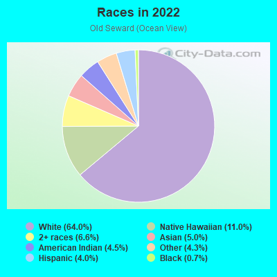
- 1,51864.0%White
- 26011.0%Native Hawaiian and Other
Pacific Islander - 1576.6%Two or more races
- 1185.0%Asian
- 1064.5%American Indian
- 1014.3%Some other race
- 954.0%Hispanic or Latino
- 160.7%Black
Median household income in 2022:
| Old Seward (Ocean View): | $162,773 |
| Anchorage: | $100,751 |
Distribution of median household income
![Distribution of median household income]()
- 8Less than $10,000
- 46$10,000 to $19,999
- 103$20,000 to $29,999
- 41$30,000 to $39,999
- 69$40,000 to $49,999
- 12$50,000 to $59,999
- 41$60,000 to $74,999
- 49$75,000 to $99,999
- 87$100,000 to $124,999
- 43$125,000 to $149,999
- 112$150,000 to $199,999
- 283$200,000 or more

Distribution of owner-occupied house/condo value
![Distribution of owner-occupied house/condo value]()
- 9Less than $50,000
- 91$50,000 to $99,999
- 4$100,000 to $149,999
- 3$150,000 to $199,999
- 63$200,000 to $249,999
- 14$250,000 to $299,999
- 46$300,000 to $399,999
- 111$400,000 to $499,999
- 270$500,000 to $749,999
- 97$750,000 to $999,999
- 117$1,000,000 or more

Distribution of rent paid by renters
![Distribution of rent paid by renters]()
- 81$600 to $699
- 81$700 to $799
- 3$800 to $899
- 118$900 to $999
- 7$1,000 to $1,249
- 69$1,250 to $1,499
- 241$1,500 to $1,999
- 158$2,000 or more

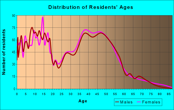
| Males: | 984 |
| Females: | 1,028 |
Males:
| This neighborhood: | 41.7 years |
| Whole city: | 34.8 years |
| This neighborhood: | 39.5 years |
| Whole city: | 36.0 years |
Average household size:
| Old Seward (Ocean View): | 2.9 people |
| Anchorage: | 2.5 people |
Percentage of family households:
| Old Seward (Ocean View): | 57.2% |
| Anchorage: | 49.0% |
| Here: | 68.7% |
| Anchorage: | 45.5% |
Percentage of married-couple families with children (among all households):
| Old Seward (Ocean View): | 28.6% |
| Anchorage: | 23.6% |
Percentage of single-mother households (among all households):
| Old Seward (Ocean View): | 3.8% |
| Anchorage: | 10.8% |
Percentage of never married males 15 years old and over:
Percentage of never married females 15 years old and over:
| Old Seward (Ocean View): | 12.6% |
| Anchorage: | 20.0% |
Percentage of never married females 15 years old and over:
| Old Seward (Ocean View): | 12.2% |
| city: | 15.3% |
Percentage of people that speak English not well or not at all:
| Old Seward (Ocean View): | 0.0% |
| Anchorage: | 2.1% |
Percentage of people born in this state:
Percentage of people born in another U.S. state:
Percentage of native residents but born outside the U.S.:
Percentage of foreign born residents:
| Here: | 40.5% |
| Anchorage: | 40.3% |
Percentage of people born in another U.S. state:
| Old Seward (Ocean View): | 52.1% |
| Anchorage: | 46.0% |
Percentage of native residents but born outside the U.S.:
| Here: | 1.2% |
| city: | 3.4% |
Percentage of foreign born residents:
| Here: | 6.3% |
| Anchorage: | 10.4% |
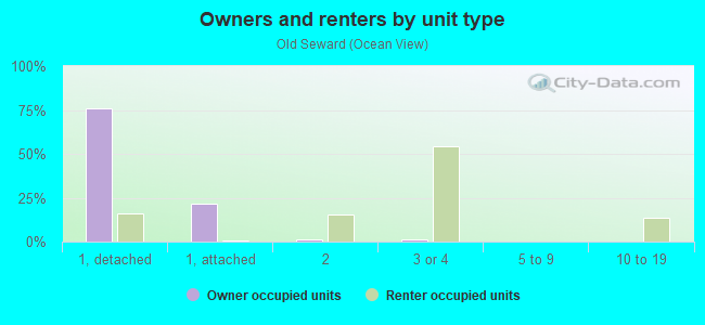
Owner-occupied
Renter-occupied

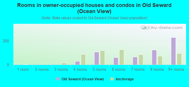
- Rooms in owner-occupied houses and condos in Old Seward <
> - 01 room
- 02 rooms
- 03 rooms
- 304 rooms
- 1075 rooms
- 616 rooms
- 657 rooms
- 1248 rooms
- 2309+ rooms
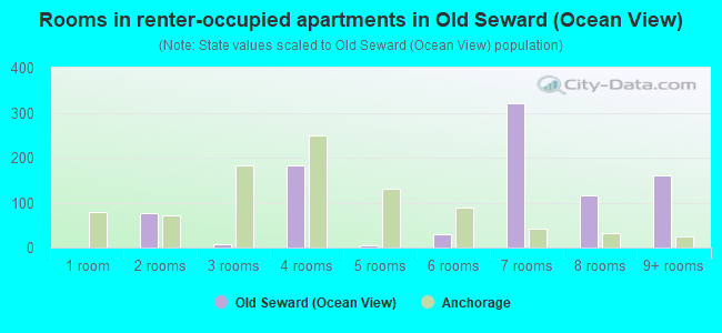
- Rooms in renter-occupied apartments in Old Seward <
> - 01 room
- 772 rooms
- 73 rooms
- 1824 rooms
- 65 rooms
- 306 rooms
- 3227 rooms
- 1178 rooms
- 1609+ rooms
Owner-occupied
Renter-occupied
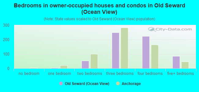
- Bedrooms in owner-occupied houses and condos in Old Seward <
> - 0no bedroom
- 51 bedroom
- 542 bedrooms
- 2503 bedrooms
- 2244 bedrooms
- 865+ bedrooms
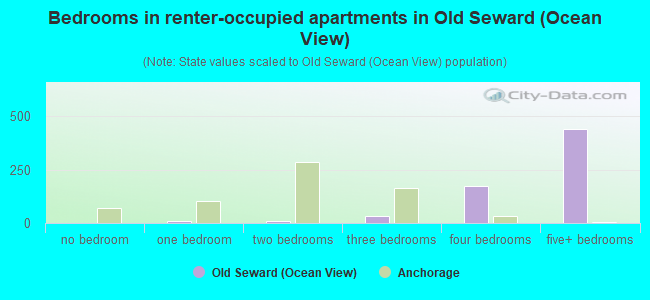
- Bedrooms in renter-occupied apartments in Old Seward <
> - 0no bedroom
- 81 bedroom
- 82 bedrooms
- 323 bedrooms
- 1754 bedrooms
- 4405+ bedrooms
Average number of cars or other vehicles available in houses/condos:
Average number of cars or other vehicles available in apartments:
| This neighborhood: | 2.3 |
| Anchorage: | 2.2 |
Average number of cars or other vehicles available in apartments:
| Here: | |
| city: |
Percentage of units with a mortgage:
| Old Seward (Ocean View): | 67.3% |
| Anchorage: | 70.7% |
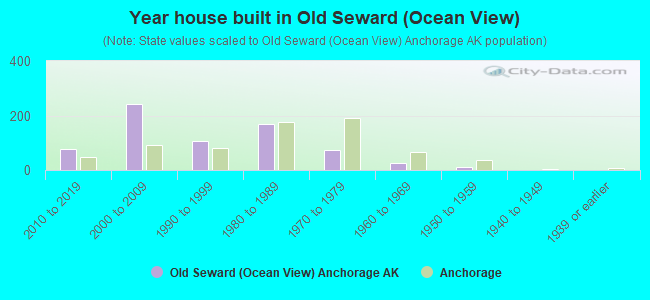
- Year house built in Old Seward <
> - 02020 or later
- 762010 to 2019
- 2442000 to 2009
- 1051990 to 1999
- 1671980 to 1989
- 731970 to 1979
- 271960 to 1969
- 121950 to 1959
- 01940 to 1949
- 01939 or earlier
City-data.com crime index for city in 2020 (higher means more crime):
| City: | 559.2 |
| U.S. average: | 219.5 |
Travel time to work (commute)
![Travel time to work (commute)]()
- 160Less than 5 minutes
- 815 to 9 minutes
- 14210 to 14 minutes
- 44215 to 19 minutes
- 51920 to 24 minutes
- 11925 to 29 minutes
- 12230 to 34 minutes
- 5335 to 39 minutes
- 21640 to 44 minutes
- 1345 to 59 minutes
- 1160 to 89 minutes
- 2590 or more minutes

Means of transportation to work
![Means of transportation to work]()
- 81.8%734Drove a car alone
- 8.9%80Carpooled
- 3.3%30Bus
- 7.4%66Taxi
- 33.6%301Walked
- 2.0%18Other means
- 8.0%72Worked at home

Time leaving home to go to work
![Time leaving home to go to work]()
- 5112:00 a.m. to 4:59 a.m.
- 585:30 a.m. to 5:59 a.m.
- 1016:00 a.m. to 6:29 a.m.
- 1016:30 a.m. to 6:59 a.m.
- 2287:00 a.m. to 7:29 a.m.
- 4307:30 a.m. to 7:59 a.m.
- 2198:00 a.m. to 8:29 a.m.
- 418:30 a.m. to 8:59 a.m.
- 949:00 a.m. to 9:59 a.m.
- 3410:00 a.m. to 10:59 a.m.
- 1611:00 a.m. to 11:59 a.m.
- 7912:00 p.m. to 3:59 p.m.
- 394:00 p.m. to 11:59 p.m.

Occupations of males:
- Percentage of males in management occupations (except farmers):
Here: 19.2% city: 11.1%
- Percentage of males in business and financial operations occupations:
Here: 4.9% city: 4.5%
- Percentage of males in computer and mathematical occupations:
Here: 7.9% city: 3.6%
- Percentage of males in architecture and engineering occupations:
Here: 6.4% city: 4.2%
- Percentage of males in life, physical, and social science occupations:
Here: 3.6% city: 1.6%
- Percentage of males in community and social services occupations:
Here: 1.1% city: 1.2%
- Percentage of males in legal occupations:
Here: 2.1% city: 1.3%
- Percentage of males in education, training, and library occupations:
Here: 4.5% city: 3.5%
- Percentage of males in healthcare practitioners and technical occupations:
Here: 11.1% city: 3.7%
- Percentage of males in service occupations:
Here: 6.7% city: 17.2%
- Percentage of males in sales and office occupations:
Here: 3.3% city: 14.9%
- Percentage of males in construction, extraction, and maintenance occupations:
Here: 9.6% city: 7.3%
- Percentage of males in transportation occupations:
Here: 9.5% city: 8.0%
- Percentage of males in material moving occupations:
Here: 6.4% city: 5.7%
Occupations of females:
- Percentage of females in management occupations (except farmers):
Here: 19.2% city: 10.4%
- Percentage of females in business and financial operations occupations:
Here: 7.3% city: 7.1%
- Percentage of females in computer and mathematical occupations:
Here: 2.9% city: 1.2%
- Percentage of females in life, physical, and social science occupations:
Here: 7.8% city: 2.3%
- Percentage of females in community and social services occupations:
Here: 1.5% city: 2.6%
- Percentage of females in legal occupations:
Here: 2.3% city: 1.6%
- Percentage of females in education, training, and library occupations:
Here: 6.9% city: 9.0%
- Percentage of females in arts, design, entertainment, sports, and media occupations:
Here: 1.1% city: 2.6%
- Percentage of females in healthcare practitioners and technical occupations:
Here: 17.4% city: 9.6%
- Percentage of females in service occupations:
Here: 9.8% city: 19.2%
- Percentage of females in sales and office occupations:
Here: 18.1% city: 27.3%
- Percentage of females in farming, fishing, and forestry occupations:
Here: 1.4% city: 0.2%
- Percentage of females in transportation occupations:
Here: 3.1% city: 1.7%
Percentage of people 16-64 in Armed Forces:
| Old Seward (Ocean View): | 0.7% |
| Anchorage: | 5.7% |
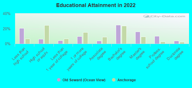
Education in this neighborhood (subdivision or community):
- Percentage of people 3 years and older in K-12 schools:
Old Seward (Ocean View): 24.2% Anchorage: 17.3%
- Percentage of people 3 years and older in undergraduate colleges:
Old Seward (Ocean View): 2.6% Anchorage: 3.9%
- Percentage of people 3 years and older in grad. or professional schools:
Old Seward (Ocean View): 1.0% Anchorage: 1.1%
- Percentage of students K-12 enrolled in private schools:
Old Seward (Ocean View): 25.1% Anchorage: 11.6%
Percentage of population below poverty level:
| Old Seward (Ocean View): | 3.1% |
| Anchorage: | 11.1% |
Median year owner moved in (as recorded in 2022):
| Old Seward (Ocean View): | 2009 |
| Anchorage: | 2013 |
Percentage of married-couple families with both working:
| Old Seward (Ocean View): | 72.6% |
| Anchorage: | 79.2% |
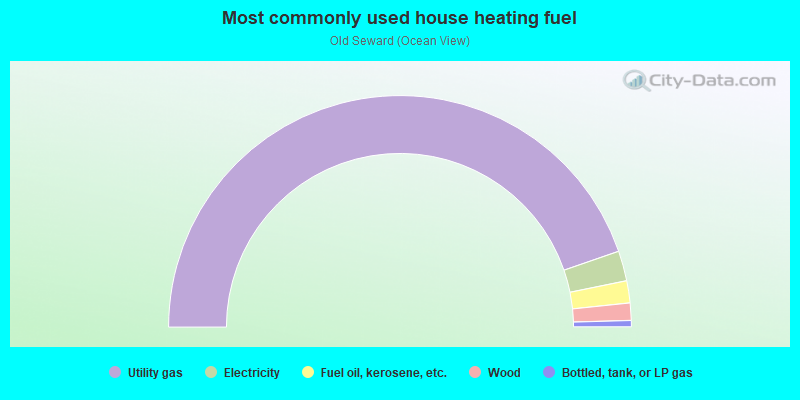
- 89.4%Utility gas
- 4.2%Electricity
- 3.1%Fuel oil, kerosene, etc.
- 2.4%Wood
- 0.9%Bottled, tank, or LP gas
Highways in this neighborhood:
New Seward Hwy (State Hwy 1)
Length: 2.67 miles
Directions: N-S, SE-NW
Directions: N-S, SE-NW
Seward Hwy (New Seward Hwy, State Hwy 1)
Length: 0.55 miles
Directions: N-S, SE-NW
Directions: N-S, SE-NW
Roads and streets:
Old Seward Hwy
Length: 2.88 miles
Directions: E-W, N-S, SE-NW
Address range: 11800 to 14831
Directions: E-W, N-S, SE-NW
Address range: 11800 to 14831
Oceanview Dr
Length: 1.81 miles
Directions: E-W, N-S, SE-NW
Address range: 300 to 1699
Directions: E-W, N-S, SE-NW
Address range: 300 to 1699
Huffman Rd
Length: 1.74 miles
Direction: E-W
Address range: 629 to 1599
Direction: E-W
Address range: 629 to 1599
Jarvi Dr
Length: 1.37 miles
Directions: E-W, N-S, SE-NW, SW-NE
Address range: 13419 to 14399
Directions: E-W, N-S, SE-NW, SW-NE
Address range: 13419 to 14399
Regon St (E 120th Ave)
Length: 1.03 miles
Direction: E-W
Direction: E-W
High View Dr
Length: 0.96 miles
Directions: E-W, N-S, SE-NW
Address range: 200 to 13142
Directions: E-W, N-S, SE-NW
Address range: 200 to 13142
Gwenn Dr
Length: 0.91 miles
Directions: E-W, SE-NW, SW-NE
Address range: 1400 to 14099
Directions: E-W, SE-NW, SW-NE
Address range: 1400 to 14099
Johns Rd
Length: 0.76 miles
Direction: N-S
Address range: 11800 to 12999
Direction: N-S
Address range: 11800 to 12999
Jarvis Ave
Length: 0.75 miles
Direction: E-W
Address range: 1800 to 2205
Direction: E-W
Address range: 1800 to 2205
Mariner Dr
Length: 0.70 miles
Directions: E-W, N-S, SE-NW, SW-NE
Address range: 200 to 12899
Directions: E-W, N-S, SE-NW, SW-NE
Address range: 200 to 12899
Bounty Dr
Length: 0.69 miles
Directions: E-W, SE-NW
Address range: 500 to 999
Directions: E-W, SE-NW
Address range: 500 to 999
Stephenson St
Length: 0.62 miles
Directions: E-W, N-S, SE-NW, SW-NE
Address range: 12800 to 13463
Directions: E-W, N-S, SE-NW, SW-NE
Address range: 12800 to 13463
Pettis Rd
Length: 0.61 miles
Directions: E-W, N-S, SE-NW, SW-NE
Address range: 100 to 464
Directions: E-W, N-S, SE-NW, SW-NE
Address range: 100 to 464
Harding Dr (Helen Dr)
Length: 0.60 miles
Directions: E-W, SW-NE
Address range: 1400 to 1799
Directions: E-W, SW-NE
Address range: 1400 to 1799
Hancock Dr
Length: 0.54 miles
Directions: E-W, SE-NW, SW-NE
Address range: 14100 to 14299
Directions: E-W, SE-NW, SW-NE
Address range: 14100 to 14299
Dailey Ave
Length: 0.53 miles
Direction: E-W
Address range: 200 to 599
Direction: E-W
Address range: 200 to 599
Birch Knoll Loop
Length: 0.51 miles
Directions: E-W, N-S, SE-NW, SW-NE
Address range: 11616 to 11799
Directions: E-W, N-S, SE-NW, SW-NE
Address range: 11616 to 11799
Diggins Dr
Length: 0.51 miles
Directions: E-W, N-S, SE-NW
Address range: 13300 to 13537
Directions: E-W, N-S, SE-NW
Address range: 13300 to 13537
Hamilton Dr
Length: 0.50 miles
Directions: E-W, N-S
Address range: 1700 to 1945
Directions: E-W, N-S
Address range: 1700 to 1945
Brandon St
Length: 0.50 miles
Direction: N-S
Address range: 12401 to 13199
Direction: N-S
Address range: 12401 to 13199
Specking Ave
Length: 0.50 miles
Directions: N-S, SE-NW
Address range: 13700 to 14212
Directions: N-S, SE-NW
Address range: 13700 to 14212
de Armoun Rd
Length: 0.49 miles
Direction: E-W
Address range: 2100 to 2199
Direction: E-W
Address range: 2100 to 2199
Cara Loop (Craig St)
Length: 0.48 miles
Directions: E-W, N-S, SE-NW
Address range: 1500 to 1742
Directions: E-W, N-S, SE-NW
Address range: 1500 to 1742
Bree Ave
Length: 0.45 miles
Directions: E-W, N-S, SE-NW, SW-NE
Address range: 100 to 325
Directions: E-W, N-S, SE-NW, SW-NE
Address range: 100 to 325
W 123rd Ave
Length: 0.44 miles
Direction: E-W
Address range: 200 to 442
Direction: E-W
Address range: 200 to 442
W 121st Ave
Length: 0.44 miles
Direction: E-W
Address range: 200 to 499
Direction: E-W
Address range: 200 to 499
Karen St
Length: 0.44 miles
Directions: E-W, N-S, SE-NW, SW-NE
Address range: 13400 to 13837
Directions: E-W, N-S, SE-NW, SW-NE
Address range: 13400 to 13837
Venus Way
Length: 0.44 miles
Directions: E-W, N-S, SE-NW
Address range: 13200 to 13607
Directions: E-W, N-S, SE-NW
Address range: 13200 to 13607
Industry Way
Length: 0.43 miles
Directions: E-W, N-S, SE-NW
Address range: 11900 to 12399
Directions: E-W, N-S, SE-NW
Address range: 11900 to 12399
Sunset Dr (Sunview Dr)
Length: 0.43 miles
Directions: E-W, SE-NW
Address range: 14000 to 14399
Directions: E-W, SE-NW
Address range: 14000 to 14399
Huffman Park Dr
Length: 0.43 miles
Directions: E-W, N-S, SE-NW
Address range: 1200 to 1499
Directions: E-W, N-S, SE-NW
Address range: 1200 to 1499
Nora Dr
Length: 0.42 miles
Directions: E-W, N-S, SE-NW, SW-NE
Address range: 12800 to 13199
Directions: E-W, N-S, SE-NW, SW-NE
Address range: 12800 to 13199
Pacific View Dr
Length: 0.42 miles
Direction: E-W
Address range: 100 to 398
Direction: E-W
Address range: 100 to 398
Tanada Loop
Length: 0.42 miles
Directions: E-W, N-S, SE-NW, SW-NE
Address range: 12501 to 12767
Directions: E-W, N-S, SE-NW, SW-NE
Address range: 12501 to 12767
Lighthouse Ct (Lighthouse Dr)
Length: 0.41 miles
Direction: E-W
Address range: 600 to 999
Direction: E-W
Address range: 600 to 999
Innes Cir
Length: 0.41 miles
Directions: E-W, N-S, SE-NW, SW-NE
Address range: 2000 to 2398
Directions: E-W, N-S, SE-NW, SW-NE
Address range: 2000 to 2398
Ellen Ave
Length: 0.40 miles
Direction: N-S
Address range: 11730 to 12399
Direction: N-S
Address range: 11730 to 12399
Kayak Dr (Kayak Pl)
Length: 0.40 miles
Directions: E-W, N-S, SE-NW, SW-NE
Address range: 315 to 12899
Directions: E-W, N-S, SE-NW, SW-NE
Address range: 315 to 12899
Ocean Park Dr
Length: 0.40 miles
Directions: E-W, N-S
Address range: 100 to 199
Directions: E-W, N-S
Address range: 100 to 199
Labar St
Length: 0.39 miles
Direction: E-W
Address range: 1200 to 1399
Direction: E-W
Address range: 1200 to 1399
Ocean Point Dr
Length: 0.38 miles
Directions: E-W, N-S, SE-NW
Address range: 300 to 599
Directions: E-W, N-S, SE-NW
Address range: 300 to 599
Beachcomber Dr
Length: 0.37 miles
Directions: E-W, N-S, SW-NE
Address range: 12400 to 12699
Directions: E-W, N-S, SW-NE
Address range: 12400 to 12699
Hace St
Length: 0.37 miles
Direction: N-S
Address range: 12400 to 12925
Direction: N-S
Address range: 12400 to 12925
Turnagain Bluff Way
Length: 0.37 miles
Directions: N-S, SE-NW, SW-NE
Address range: 14500 to 14799
Directions: N-S, SE-NW, SW-NE
Address range: 14500 to 14799
Silver Fox Ln
Length: 0.36 miles
Direction: SE-NW
Address range: 12400 to 12799
Direction: SE-NW
Address range: 12400 to 12799
Cotoneaster Cir (Orchid Cir)
Length: 0.35 miles
Directions: E-W, N-S, SE-NW, SW-NE
Address range: 300 to 699
Directions: E-W, N-S, SE-NW, SW-NE
Address range: 300 to 699
Brant Way
Length: 0.32 miles
Directions: E-W, SE-NW
Address range: 13200 to 13506
Directions: E-W, SE-NW
Address range: 13200 to 13506
Bonnie Jean Ct
Length: 0.32 miles
Direction: E-W
Address range: 200 to 445
Direction: E-W
Address range: 200 to 445
Botanical Cir
Length: 0.32 miles
Directions: E-W, N-S, SE-NW, SW-NE
Address range: 100 to 299
Directions: E-W, N-S, SE-NW, SW-NE
Address range: 100 to 299
Cross Rd
Length: 0.32 miles
Direction: E-W
Address range: 1100 to 1399
Direction: E-W
Address range: 1100 to 1399
George Bell Cir
Length: 0.31 miles
Directions: E-W, SW-NE
Address range: 1601 to 1765
Directions: E-W, SW-NE
Address range: 1601 to 1765
Mary Ave
Length: 0.28 miles
Direction: N-S
Address range: 5782 to 12247
Direction: N-S
Address range: 5782 to 12247
Dennis Way
Length: 0.26 miles
Direction: E-W
Address range: 2300 to 2498
Direction: E-W
Address range: 2300 to 2498
Coral Ln
Length: 0.26 miles
Directions: E-W, N-S, SE-NW, SW-NE
Address range: 900 to 14180
Directions: E-W, N-S, SE-NW, SW-NE
Address range: 900 to 14180
Schooner Dr
Length: 0.26 miles
Directions: E-W, N-S, SE-NW
Address range: 12639 to 12737
Directions: E-W, N-S, SE-NW
Address range: 12639 to 12737
Clipper Ship Ct
Length: 0.26 miles
Direction: E-W
Address range: 500 to 699
Direction: E-W
Address range: 500 to 699
Kruge Ave
Length: 0.26 miles
Direction: E-W
Address range: 1400 to 1405
Direction: E-W
Address range: 1400 to 1405
Harbor Cir
Length: 0.25 miles
Direction: E-W
Address range: 700 to 917
Direction: E-W
Address range: 700 to 917
Landmark St
Length: 0.25 miles
Direction: N-S
Address range: 12416 to 12747
Direction: N-S
Address range: 12416 to 12747
Division St
Length: 0.25 miles
Direction: N-S
Address range: 12000 to 12399
Direction: N-S
Address range: 12000 to 12399
Sunset View St
Length: 0.25 miles
Directions: E-W, SE-NW
Address range: 13600 to 13799
Directions: E-W, SE-NW
Address range: 13600 to 13799
Galleon Dr
Length: 0.23 miles
Direction: E-W
Address range: 200 to 399
Direction: E-W
Address range: 200 to 399
Breakwater Cir
Length: 0.21 miles
Directions: E-W, SE-NW
Address range: 700 to 899
Directions: E-W, SE-NW
Address range: 700 to 899
Ellen Cir
Length: 0.21 miles
Direction: E-W
Address range: 200 to 399
Direction: E-W
Address range: 200 to 399
Bill St
Length: 0.20 miles
Direction: E-W
Address range: 600 to 735
Direction: E-W
Address range: 600 to 735
Jack St
Length: 0.20 miles
Direction: E-W
Address range: 600 to 736
Direction: E-W
Address range: 600 to 736
Dare Ave
Length: 0.20 miles
Directions: E-W, SW-NE
Address range: 1800 to 1899
Directions: E-W, SW-NE
Address range: 1800 to 1899
Botanical Hts
Length: 0.20 miles
Directions: E-W, SE-NW
Address range: 822 to 1099
Directions: E-W, SE-NW
Address range: 822 to 1099
Shelly Marie Cir
Length: 0.19 miles
Direction: E-W
Address range: 100 to 199
Direction: E-W
Address range: 100 to 199
Langnes Ct
Length: 0.19 miles
Directions: E-W, N-S
Address range: 200 to 399
Directions: E-W, N-S
Address range: 200 to 399
Tammy Ave
Length: 0.18 miles
Direction: E-W
Address range: 1535 to 1735
Direction: E-W
Address range: 1535 to 1735
Clements Dr
Length: 0.17 miles
Direction: E-W
Address range: 2300 to 2499
Direction: E-W
Address range: 2300 to 2499
Reef Pl
Length: 0.17 miles
Directions: N-S, SE-NW, SW-NE
Address range: 13200 to 13399
Directions: N-S, SE-NW, SW-NE
Address range: 13200 to 13399
Admiralty Pl
Length: 0.16 miles
Directions: N-S, SW-NE
Address range: 12900 to 13045
Directions: N-S, SW-NE
Address range: 12900 to 13045
Joham Cir
Length: 0.16 miles
Direction: E-W
Address range: 900 to 956
Direction: E-W
Address range: 900 to 956
Elmhurst Dr
Length: 0.15 miles
Directions: E-W, N-S, SE-NW, SW-NE
Address range: 13200 to 13299
Directions: E-W, N-S, SE-NW, SW-NE
Address range: 13200 to 13299
Back Rd
Length: 0.15 miles
Directions: N-S, SE-NW
Address range: 12900 to 13199
Directions: N-S, SE-NW
Address range: 12900 to 13199
Showers Ave
Length: 0.14 miles
Directions: E-W, N-S
Address range: 100 to 199
Directions: E-W, N-S
Address range: 100 to 199
Arne Erickson Cir
Length: 0.14 miles
Directions: E-W, N-S, SE-NW
Address range: 13700 to 13799
Directions: E-W, N-S, SE-NW
Address range: 13700 to 13799
Nix Ct
Length: 0.13 miles
Directions: E-W, N-S
Address range: 11600 to 11762
Directions: E-W, N-S
Address range: 11600 to 11762
Clipper Ship Dr
Length: 0.13 miles
Directions: N-S, SW-NE
Address range: 501 to 12527
Directions: N-S, SW-NE
Address range: 501 to 12527
Winfield Cir
Length: 0.13 miles
Direction: E-W
Address range: 400 to 456
Direction: E-W
Address range: 400 to 456
Tanada Cir
Length: 0.13 miles
Directions: E-W, N-S, SE-NW
Address range: 12637 to 12717
Directions: E-W, N-S, SE-NW
Address range: 12637 to 12717
Gambell St
Length: 0.12 miles
Direction: N-S
Address range: 11800 to 11999
Direction: N-S
Address range: 11800 to 11999
Briny Cir
Length: 0.11 miles
Direction: E-W
Address range: 700 to 899
Direction: E-W
Address range: 700 to 899
Breeze Ct
Length: 0.11 miles
Direction: E-W
Address range: 300 to 399
Direction: E-W
Address range: 300 to 399
Crows Cir
Length: 0.11 miles
Directions: E-W, N-S, SW-NE
Address range: 12800 to 12899
Directions: E-W, N-S, SW-NE
Address range: 12800 to 12899
Hancock Ln
Length: 0.10 miles
Directions: N-S, SE-NW
Address range: 14300 to 14399
Directions: N-S, SE-NW
Address range: 14300 to 14399
Ledora Cir
Length: 0.10 miles
Direction: E-W
Address range: 500 to 544
Direction: E-W
Address range: 500 to 544
Gail St
Length: 0.10 miles
Direction: N-S
Address range: 12801 to 12926
Direction: N-S
Address range: 12801 to 12926
Troy St
Length: 0.10 miles
Direction: N-S
Address range: 12800 to 12935
Direction: N-S
Address range: 12800 to 12935
Bates Cir
Length: 0.09 miles
Directions: E-W, SE-NW
Address range: 13000 to 13099
Directions: E-W, SE-NW
Address range: 13000 to 13099
Deerfield Dr
Length: 0.09 miles
Direction: E-W
Direction: E-W
Highland Park Ave
Length: 0.09 miles
Direction: E-W
Direction: E-W
Gregg Ln
Length: 0.08 miles
Directions: N-S, SW-NE
Address range: 12200 to 12399
Directions: N-S, SW-NE
Address range: 12200 to 12399
Cove Cir
Length: 0.08 miles
Directions: N-S, SE-NW
Address range: 13300 to 13399
Directions: N-S, SE-NW
Address range: 13300 to 13399
Elmhurst Cir
Length: 0.08 miles
Directions: E-W, N-S
Address range: 13100 to 13199
Directions: E-W, N-S
Address range: 13100 to 13199
Giroux Cir
Length: 0.07 miles
Directions: E-W, N-S
Address range: 600 to 699
Directions: E-W, N-S
Address range: 600 to 699
Oomiak Cir
Length: 0.07 miles
Directions: E-W, SE-NW
Address range: 12800 to 12899
Directions: E-W, SE-NW
Address range: 12800 to 12899
Ben Ct
Length: 0.07 miles
Direction: E-W
Direction: E-W
Knowles Cir
Length: 0.06 miles
Direction: E-W
Address range: 100 to 199
Direction: E-W
Address range: 100 to 199
Neptune Ct
Length: 0.06 miles
Direction: E-W
Direction: E-W
Beach Cir
Length: 0.06 miles
Direction: SW-NE
Address range: 13100 to 13199
Direction: SW-NE
Address range: 13100 to 13199
Sunset View Cir
Length: 0.05 miles
Direction: E-W
Address range: 13601 to 13737
Direction: E-W
Address range: 13601 to 13737
Karen Cir
Length: 0.05 miles
Directions: E-W, SE-NW
Address range: 13629 to 13667
Directions: E-W, SE-NW
Address range: 13629 to 13667
Gulf Cir
Length: 0.05 miles
Directions: N-S, SW-NE
Address range: 13100 to 13199
Directions: N-S, SW-NE
Address range: 13100 to 13199
Majella Cir
Length: 0.05 miles
Direction: E-W
Address range: 1400 to 1499
Direction: E-W
Address range: 1400 to 1499
Fawn Ct
Length: 0.05 miles
Direction: N-S
Address range: 201 to 273
Direction: N-S
Address range: 201 to 273
Cape Cir
Length: 0.05 miles
Direction: N-S
Address range: 13100 to 13199
Direction: N-S
Address range: 13100 to 13199
Harriet Ct
Length: 0.05 miles
Direction: E-W
Address range: 1525 to 1549
Direction: E-W
Address range: 1525 to 1549
Lagoon Cir
Length: 0.05 miles
Direction: SW-NE
Address range: 13000 to 13099
Direction: SW-NE
Address range: 13000 to 13099
Hansa Rose Cir
Length: 0.05 miles
Directions: SE-NW, SW-NE
Address range: 12500 to 12599
Directions: SE-NW, SW-NE
Address range: 12500 to 12599
Aro Cir
Length: 0.05 miles
Direction: SW-NE
Address range: 12901 to 12947
Direction: SW-NE
Address range: 12901 to 12947
Caragana Cir
Length: 0.05 miles
Directions: SE-NW, SW-NE
Address range: 12400 to 12499
Directions: SE-NW, SW-NE
Address range: 12400 to 12499
Landmark Ct
Length: 0.05 miles
Direction: E-W
Address range: 12601 to 12635
Direction: E-W
Address range: 12601 to 12635
Whitecap Pl
Length: 0.05 miles
Direction: N-S
Address range: 12000 to 12099
Direction: N-S
Address range: 12000 to 12099
Tidepool Pl
Length: 0.05 miles
Direction: N-S
Address range: 12000 to 12099
Direction: N-S
Address range: 12000 to 12099
Seashore Pl
Length: 0.05 miles
Direction: N-S
Address range: 12000 to 12099
Direction: N-S
Address range: 12000 to 12099
Coral Reef Pl
Length: 0.05 miles
Direction: N-S
Address range: 12000 to 12099
Direction: N-S
Address range: 12000 to 12099
Anchor Pl
Length: 0.05 miles
Direction: N-S
Address range: 12000 to 12099
Direction: N-S
Address range: 12000 to 12099
Timberlane Cir
Length: 0.05 miles
Directions: E-W, SW-NE
Address range: 601 to 698
Directions: E-W, SW-NE
Address range: 601 to 698
Bay Cir
Length: 0.04 miles
Direction: N-S
Address range: 13100 to 13199
Direction: N-S
Address range: 13100 to 13199
Scottie Ct
Length: 0.04 miles
Direction: N-S
Address range: 13100 to 13199
Direction: N-S
Address range: 13100 to 13199
Chellie's Cir (Chellies Cir)
Length: 0.04 miles
Direction: E-W
Address range: 600 to 699
Direction: E-W
Address range: 600 to 699
Maho Cir
Length: 0.04 miles
Directions: E-W, SW-NE
Address range: 901 to 943
Directions: E-W, SW-NE
Address range: 901 to 943
W 121st Cir
Length: 0.04 miles
Direction: E-W
Address range: 500 to 599
Direction: E-W
Address range: 500 to 599
Galleon Cir
Length: 0.04 miles
Direction: N-S
Address range: 12626 to 12717
Direction: N-S
Address range: 12626 to 12717
Beaufort Cir
Length: 0.03 miles
Direction: N-S
Direction: N-S
Mary Cir
Length: 0.03 miles
Direction: E-W
Address range: 500 to 599
Direction: E-W
Address range: 500 to 599
Hoppa Cir
Length: 0.03 miles
Direction: N-S
Address range: 1238 to 12499
Direction: N-S
Address range: 1238 to 12499
Stephenson Cir
Length: 0.03 miles
Direction: E-W
Direction: E-W
Nautilus Ct
Length: 0.03 miles
Direction: N-S
Address range: 12600 to 12799
Direction: N-S
Address range: 12600 to 12799
Timberlane Dr
Length: 0.02 miles
Direction: N-S
Address range: 11701 to 11832
Direction: N-S
Address range: 11701 to 11832
Railroad features:
The Alaska RR
Length: 3.82 miles
Directions: E-W, N-S, SE-NW
Directions: E-W, N-S, SE-NW
Other features:
Furrow Crk
Length: 3.08 miles
Directions: E-W, N-S, SE-NW, SW-NE
Directions: E-W, N-S, SE-NW, SW-NE
Little Rabbit Crk
Length: 0.10 miles
Direction: E-W
Direction: E-W