Shady Grove, Tennessee
Submit your own pictures of this place and show them to the world
- OSM Map
- General Map
- Google Map
- MSN Map

| Males: 2,084 | |
| Females: 1,998 |
| Median resident age: | 37.4 years |
| Tennessee median age: | 35.9 years |
Zip code: 38583
| Shady Grove: | $48,324 |
| TN: | $65,254 |
Estimated per capita income in 2022: $26,025 (it was $14,419 in 2000)
Shady Grove CCD income, earnings, and wages data
Estimated median house or condo value in 2022: $185,920 (it was $68,300 in 2000)
| Shady Grove: | $185,920 |
| TN: | $284,800 |
Mean prices in 2022: all housing units: $259,393; detached houses: $286,349; townhouses or other attached units: $502,256; mobile homes: $108,719
Detailed information about poverty and poor residents in Shady Grove, TN


- 3,69797.8%White alone
- 330.9%Two or more races
- 330.9%Hispanic
- 100.3%Black alone
- 40.1%American Indian alone
- 40.1%Asian alone
- 10.03%Native Hawaiian and Other
Pacific Islander alone

Races in Shady Grove detailed stats: ancestries, foreign born residents, place of birth
 Recent articles from our blog. Our writers, many of them Ph.D. graduates or candidates, create easy-to-read articles on a wide variety of topics.
Current Local Time: CST time zone
Land area: 64.1 square miles.
Population density: 64 people per square mile (very low).

| Shady Grove CCD: | 0.4% ($285) |
| Tennessee: | 0.8% ($715) |
Nearest city with pop. 50,000+: Murfreesboro, TN  (45.1 miles , pop. 68,816).
Nearest city with pop. 200,000+: Nashville-Davidson, TN (66.9 miles , pop. 545,524).
Nearest city with pop. 1,000,000+: Chicago, IL (423.2 miles , pop. 2,896,016).
Nearest cities:
), ), ), ), ), )Latitude: 35.94 N, Longitude: 85.60 W
Area code commonly used in this area: 931


| Here: | 3.3% |
| Tennessee: | 3.0% |

- Construction (9.5%)
- Transportation equipment (8.6%)
- Metal & metal products (7.2%)
- Truck transportation (5.1%)
- Agriculture, forestry, fishing & hunting (4.6%)
- Educational services (4.2%)
- Plastics & rubber products (3.8%)

- Construction (17.3%)
- Transportation equipment (9.2%)
- Agriculture, forestry, fishing & hunting (8.3%)
- Truck transportation (8.0%)
- Plastics & rubber products (5.9%)
- Metal & metal products (5.8%)
- Electrical equipment, appliances, components (5.3%)

- Metal & metal products (8.8%)
- Educational services (8.5%)
- Transportation equipment (7.9%)
- Apparel (6.9%)
- Health care (6.3%)
- Food & beverage stores (4.6%)
- Department & other general merchandise stores (4.6%)

- Other production occupations, including supervisors (10.0%)
- Assemblers and fabricators (8.2%)
- Metal workers and plastic workers (6.4%)
- Driver/sales workers and truck drivers (4.4%)
- Laborers and material movers, hand (4.0%)
- Electrical equipment mechanics and other installation, maintenance, and repair workers, including supervisors (3.7%)
- Material recording, scheduling, dispatching, and distributing workers (3.6%)

- Other production occupations, including supervisors (11.7%)
- Metal workers and plastic workers (11.0%)
- Driver/sales workers and truck drivers (8.4%)
- Farmers and farm managers (6.0%)
- Construction traders workers except carpenters, electricians, painters, plumbers, and construction laborers (6.0%)
- Assemblers and fabricators (5.9%)
- Electrical equipment mechanics and other installation, maintenance, and repair workers, including supervisors (5.4%)

- Assemblers and fabricators (10.9%)
- Other production occupations, including supervisors (8.2%)
- Textile, apparel, and furnishings workers (7.2%)
- Other office and administrative support workers, including supervisors (6.8%)
- Cashiers (6.5%)
- Secretaries and administrative assistants (5.8%)
- Preschool, kindergarten, elementary, and middle school teachers (4.2%)
Average climate in Shady Grove, Tennessee
Based on data reported by over 4,000 weather stations


(lower is better)

Air Quality Index (AQI) level in 2023 was 69.0. This is about average.
| City: | 69.0 |
| U.S.: | 72.6 |

Nitrogen Dioxide (NO2) [ppb] level in 2007 was 2.13. This is significantly better than average. Closest monitor was 21.3 miles away from the city center.
| City: | 2.13 |
| U.S.: | 5.11 |

Sulfur Dioxide (SO2) [ppb] level in 2007 was 1.72. This is about average. Closest monitor was 16.9 miles away from the city center.
| City: | 1.72 |
| U.S.: | 1.51 |

Ozone [ppb] level in 2023 was 33.7. This is about average. Closest monitor was 10.3 miles away from the city center.
| City: | 33.7 |
| U.S.: | 33.3 |

Particulate Matter (PM2.5) [µg/m3] level in 2022 was 6.46. This is better than average. Closest monitor was 16.8 miles away from the city center.
| City: | 6.46 |
| U.S.: | 8.11 |
Tornado activity:
Shady Grove-area historical tornado activity is near Tennessee state average. It is 48% greater than the overall U.S. average.
On 4/3/1974, a category F4 (max. wind speeds 207-260 mph) tornado 6.4 miles away from the Shady Grove place center killed 10 people and injured 51 people and caused between $500,000 and $5,000,000 in damages.
On 4/3/1974, a category F5 (max. wind speeds 261-318 mph) tornado 38.0 miles away from the place center killed 16 people and injured 190 people.
Earthquake activity:
Shady Grove-area historical earthquake activity is significantly above Tennessee state average. It is 139% greater than the overall U.S. average.On 4/29/2003 at 08:59:39, a magnitude 4.9 (4.4 MB, 4.6 MW, 4.9 LG, Class: Light, Intensity: IV - V) earthquake occurred 100.1 miles away from the city center
On 4/18/2008 at 09:36:59, a magnitude 5.4 (5.1 MB, 4.8 MS, 5.4 MW, 5.2 MW, Class: Moderate, Intensity: VI - VII) earthquake occurred 214.7 miles away from the city center
On 7/27/1980 at 18:52:21, a magnitude 5.2 (5.1 MB, 4.7 MS, 5.0 UK, 5.2 UK) earthquake occurred 181.2 miles away from the city center
On 11/30/1973 at 07:48:41, a magnitude 4.7 (4.7 MB, 4.6 ML) earthquake occurred 92.1 miles away from the city center
On 4/18/2008 at 09:36:59, a magnitude 5.2 (5.2 MW, Depth: 8.9 mi) earthquake occurred 214.7 miles away from Shady Grove center
On 12/12/2018 at 09:14:43, a magnitude 4.4 (4.4 MW, Depth: 4.9 mi) earthquake occurred 53.5 miles away from Shady Grove center
Magnitude types: regional Lg-wave magnitude (LG), body-wave magnitude (MB), local magnitude (ML), surface-wave magnitude (MS), moment magnitude (MW)
Natural disasters:
The number of natural disasters in White County (13) is near the US average (15).Major Disasters (Presidential) Declared: 10
Emergencies Declared: 2
Causes of natural disasters: Floods: 7, Storms: 5, Winter Storms: 4, Tornadoes: 3, Flash Flood: 1, Heavy Rain: 1, Hurricane: 1, Ice Storm: 1, Snowfall: 1, Other: 1 (Note: some incidents may be assigned to more than one category).
Hospitals and medical centers near Shady Grove:
- NHC HEALTHCARE, SPARTA (Nursing Home, about 8 miles away; SPARTA, TN)
- DOCTORS HOSPITAL (Hospital, about 13 miles away; SMITHVILLE, TN)
- SUNCREST HOME HEALTH (Home Health Center, about 13 miles away; SMITHVILLE, TN)
- NHC HEALTHCARE, SMITHVILLE (Nursing Home, about 13 miles away; SMITHVILLE, TN)
- STONES RIVER HOSPITAL AND DEKALB COMMUNITY HOSP Acute Care Hospitals (about 14 miles away; SMITHVILLE, TN)
- COOKEVILLE HEALTH CARE CENTER INC (Nursing Home, about 16 miles away; COOKEVILLE, TN)
- NHC HEALTHCARE, COOKEVILLE (Nursing Home, about 16 miles away; COOKEVILLE, TN)
Colleges/universities with over 2000 students nearest to Shady Grove:
- Tennessee Technological University (about 17 miles; Cookeville, TN; Full-time enrollment: 9,761)
- Middle Tennessee State University (about 44 miles; Murfreesboro, TN; FT enrollment: 21,628)
- Roane State Community College (about 55 miles; Harriman, TN; FT enrollment: 4,302)
- Motlow State Community College (about 57 miles; Tullahoma, TN; FT enrollment: 2,915)
- Volunteer State Community College (about 59 miles; Gallatin, TN; FT enrollment: 5,311)
- Chattanooga State Community College (about 62 miles; Chattanooga, TN; FT enrollment: 6,827)
- The University of Tennessee-Chattanooga (about 64 miles; Chattanooga, TN; FT enrollment: 10,158)
Points of interest:
Notable locations in Shady Grove: Hutchins College (A), Hensley Chapel (B), White County Landfill (C), District 3 Fire and Rescue Central View (D), District 5 Fire and Rescue Cassville (E). Display/hide their locations on the map
Churches in Shady Grove include: Spring Hill Baptist Church (A), Shiloh Church (B), Liberty Church (C), Gum Spring Church (D), Peeled Chestnut Methodist Church (E), Shady Grove Methodist Church (F), Corinth Church (G), Plainview Church (H), Hebron Church (I). Display/hide their locations on the map
Cemeteries: Swindell Cemetery (1), Hurd Cemetery (2), Hutchings Cemetery (3), Philadelphia Cemetery (4), Pollard Cemetery (5), Anderson Cemetery (6), Arnold Cemetery (7). Display/hide their locations on the map
Lake: Boiling Pond (A). Display/hide its location on the map
Streams, rivers, and creeks: Irvin Branch (A), Darkey Spring Branch (B), Collins Branch (C), Cliff Creek (D), Cedar Creek (E), Blackwell Branch (F), Gleason Creek (G), Rum Creek (H). Display/hide their locations on the map
| This place: | 2.6 people |
| Tennessee: | 2.5 people |
| This place: | 65.7% |
| Whole state: | 69.8% |
| This place: | 5.3% |
| Whole state: | 4.2% |
Likely homosexual households (counted as self-reported same-sex unmarried-partner households)
- Lesbian couples: 0.3% of all households
- Gay men: 0.1% of all households
| This place: | 16.1% |
| Whole state: | 13.5% |
| This place: | 5.9% |
| Whole state: | 5.8% |
People in group quarters in Shady Grove in 2000:
- 16 people in residential treatment centers for emotionally disturbed children
- 16 people in homes for the mentally ill
- 10 people in halfway houses
- 2 people in other noninstitutional group quarters
For population 15 years and over in Shady Grove:

- Never married: 16.7%
- Now married: 62.5%
- Separated: 1.5%
- Widowed: 8.2%
- Divorced: 12.7%
For population 25 years and over in Shady Grove:
- High school or higher: 58.5%
- Bachelor's degree or higher: 6.2%
- Graduate or professional degree: 1.4%
- Unemployed: 6.6%
- Mean travel time to work (commute): 28.1 minutes


| Here: | 14.2 |
| Tennessee average: | 13.3 |
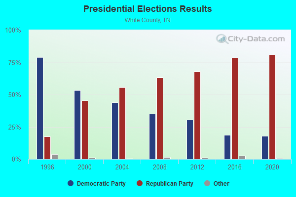
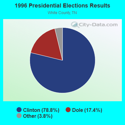
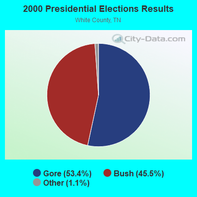

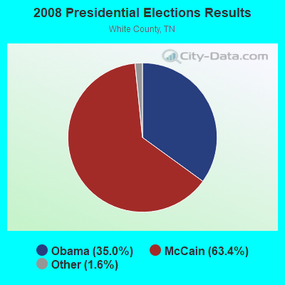


Graphs represent county-level data. Detailed 2008 Election Results
Religion statistics for Shady Grove, TN (based on White County data)
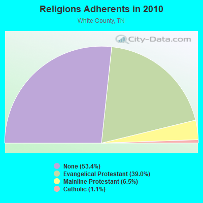
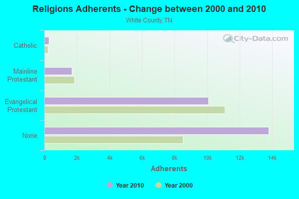
| Religion | Adherents | Congregations |
|---|---|---|
| Evangelical Protestant | 10,083 | 67 |
| Mainline Protestant | 1,680 | 20 |
| Catholic | 290 | 1 |
| Other | 1 | 1 |
| None | 13,787 | - |
Food Environment Statistics:
| This county: | 1.61 / 10,000 pop. |
| Tennessee: | 1.99 / 10,000 pop. |
| White County: | 0.80 / 10,000 pop. |
| Tennessee: | 0.65 / 10,000 pop. |
| White County: | 8.05 / 10,000 pop. |
| State: | 5.16 / 10,000 pop. |
| This county: | 5.63 / 10,000 pop. |
| Tennessee: | 6.56 / 10,000 pop. |
| White County: | 12.2% |
| Tennessee: | 11.4% |
| White County: | 30.1% |
| State: | 30.2% |
| White County: | 14.6% |
| State: | 13.5% |
Strongest AM radio stations in Shady Grove:
- WSMT (1050 AM; 1 kW; SPARTA, TN; Owner: CLEAR CHANNEL BROADCASTING LICENSES, INC.)
- WWAM (820 AM; daytime; 50 kW; JASPER, TN; Owner: SHELTON BROADCASTING SYSTEM)
- WSM (650 AM; 50 kW; NASHVILLE, TN; Owner: GAYLORD ENTERTAINMENT COMPANY)
- WTZX (860 AM; 1 kW; SPARTA, TN; Owner: CLEAR CHANNEL BROADCASTING LICENSES, INC.)
- WFLI (1070 AM; 50 kW; LOOKOUT MOUNTAIN, TN; Owner: WFLI, INC.)
- WAMB (1160 AM; 50 kW; DONELSON, TN; Owner: GREAT SOUTHERN BROADCASTING COMPANY, INC.)
- WKDA (1200 AM; 50 kW; NASHVILLE, TN; Owner: RADIO NASHVILLE, INC.)
- WLAC (1510 AM; 50 kW; NASHVILLE, TN; Owner: CAPSTAR TX LIMITED PARTNERSHIP)
- WNQM (1300 AM; 50 kW; NASHVILLE, TN; Owner: WNQM. INC.)
- WKVL (850 AM; daytime; 50 kW; KNOXVILLE, TN; Owner: HORNE RADIO, LLC)
- WPTN (780 AM; daytime; 1 kW; COOKEVILLE, TN; Owner: CLEAR CHANNEL BROADCASTING LICENSES, INC.)
- WATX (1590 AM; 2 kW; ALGOOD, TN; Owner: JWC BROADCASTING)
- WJLE (1480 AM; 1 kW; SMITHVILLE, TN; Owner: STRIBLING, LEON B. AND VANATTA, W.E.)
Strongest FM radio stations in Shady Grove:
- WRKK-FM (105.5 FM; SPARTA, TN; Owner: CLEAR CHANNEL BROADCASTING LICENSES, INC.)
- WGSQ (94.7 FM; COOKEVILLE, TN; Owner: CLEAR CHANNEL BROADCASTING LICENSES, INC.)
- WZYZ (90.1 FM; SPENCER, TN; Owner: CHURCH FAITH TRINITY ASSEMBLIES)
- W211AS (90.1 FM; SPENCER, TN; Owner: AMERICAN FAMILY ASSOCIATION)
- WGIC (98.5 FM; COOKEVILLE, TN; Owner: CLEAR CHANNEL BROADCASTING LICENSES, INC.)
- WWOG (90.9 FM; COOKEVILLE, TN; Owner: SOMERSET EDUCATIONAL BROADCASTING FOUNDATION)
- WMKW (89.3 FM; CROSSVILLE, TN; Owner: THE MOODY BIBLE INSTITUTE OF CHICAGO)
- W206AJ (89.1 FM; COOKEVILLE, TN; Owner: WAY-FM MEDIA GROUP, INC.)
- WKXD-FM (106.9 FM; MONTEREY, TN; Owner: JWC BROADCASTING)
- WKZP (107.3 FM; SPENCER, TN; Owner: CITICASTERS LICENSES, L.P.)
- WHRS (91.7 FM; COOKEVILLE, TN; Owner: NASHVILLE PUBLIC RADIO)
- WBXE (93.7 FM; BAXTER, TN; Owner: JWC BROADCASTING)
- WOWF (102.5 FM; CROSSVILLE, TN; Owner: PEG BROADCASTING, INC.)
- WLIV-FM (104.7 FM; MONTEREY, TN; Owner: WKXN INC)
- WUSY (100.7 FM; CLEVELAND, TN; Owner: CAPSTAR TX LIMITED PARTNERSHIP)
- WWTN (99.7 FM; MANCHESTER, TN; Owner: CUMULUS LICENSING CORP.)
- WLQK (95.9 FM; LIVINGSTON, TN; Owner: JWC BROADCASTING)
- WJLE-FM (101.7 FM; SMITHVILLE, TN; Owner: LEON B. STRIBLING AND W.E. VANETTA)
- WTRZ-FM (103.9 FM; MCMINNVILLE, TN; Owner: CITICASTERS LICENSES, L.P.)
TV broadcast stations around Shady Grove:
- WCTE (Channel 22; COOKEVILLE, TN; Owner: UPPER CUMBERLAND BROADCAST COUNCIL)
- WFLI-TV (Channel 53; CLEVELAND, TN; Owner: CHATTANOOGA MEDIA HOLDINGS, L.L.C.)
- WBXX-TV (Channel 20; CROSSVILLE, TN; Owner: ACME TV LICENSES OF TENNESSEE, LLC)
- W57CZ (Channel 57; COOKEVILLE, TN; Owner: TRINITY BROADCASTING NETWORK)

- 39.2%Electricity
- 32.5%Utility gas
- 17.2%Bottled, tank, or LP gas
- 10.1%Wood
- 1.0%Solar energy

- 52.4%Electricity
- 26.2%Utility gas
- 11.9%Bottled, tank, or LP gas
- 9.5%Wood
Shady Grove compared to Tennessee state average:
- Median house value below state average.
- Unemployed percentage below state average.
- Black race population percentage significantly below state average.
- Hispanic race population percentage significantly below state average.
- Foreign-born population percentage significantly below state average.
- Renting percentage significantly below state average.
- Length of stay since moving in significantly above state average.
- Number of rooms per house significantly below state average.
- House age significantly below state average.
- Institutionalized population percentage significantly above state average.
- Number of college students below state average.
- Percentage of population with a bachelor's degree or higher significantly below state average.
Shady Grove on our top lists:
- #49 on the list of "Top 101 cities with the largest percentage of people in residential treatment centers for emotionally disturbed children (population 1,000+)"
- #52 on the list of "Top 101 cities with the largest percentage of people in halfway houses (population 1,000+)"