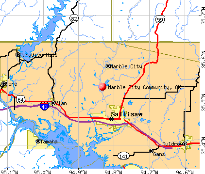
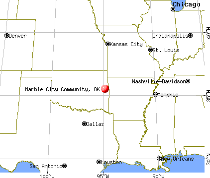
Marble City Community, Oklahoma
Submit your own pictures of this place and show them to the world
- OSM Map
- General Map
- Google Map
- MSN Map
| Males: 224 | |
| Females: 216 |
| Median resident age: | 33.8 years |
| Oklahoma median age: | 35.5 years |
Zip codes: 74945.
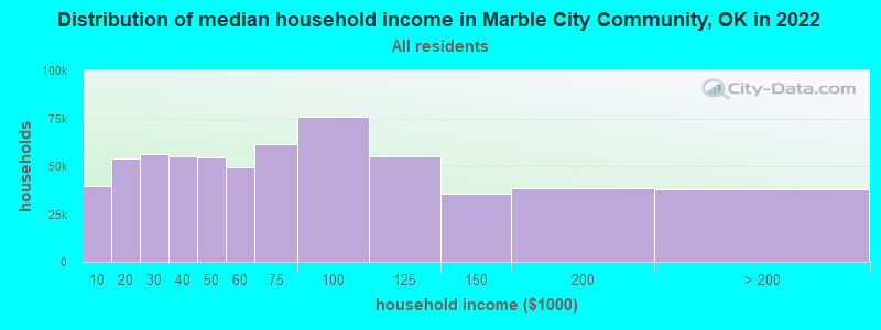
| Marble City Community: | $43,603 |
| OK: | $59,673 |
Estimated per capita income in 2022: $19,738 (it was $10,936 in 2000)
Marble City Community CDP income, earnings, and wages data
Estimated median house or condo value in 2022: $110,965 (it was $47,100 in 2000)
| Marble City Community: | $110,965 |
| OK: | $191,700 |
Mean prices in 2022: all housing units: $162,208; detached houses: $182,883; townhouses or other attached units: $177,976; in 3-to-4-unit structures: $104,270; mobile homes: $77,817; occupied boats, rvs, vans, etc.: $9,790
Marble City Community, OK residents, houses, and apartments details
Detailed information about poverty and poor residents in Marble City Community, OK
Compare current foreclosures near Marble City Community, OK:
| Photo | Address | Area | Beds / Baths | Price | Details |
|---|---|---|---|---|---|

|
#1
S 4710 Rd
Muldrow, OK 74948
|
1,508 sq. feet
|
2 baths 3 beds |
show details | |

|
#2
N Dennis St
Vian, OK 74962
|
2,320 sq. feet
|
1 baths 3 beds |
show details | |

|
#3
N Maple St
Sallisaw, OK 74955
|
880 sq. feet
|
1 baths 2 beds |
show details | |

|
#4
E 990 Rd
Vian, OK 74962
|
- sq. feet
|
2 baths 3 beds |
show details | |

|
#5
W Lee St
Vian, OK 74962
|
1,645 sq. feet
|
2 baths 3 beds |
show details | |

|
#6
S 4740 Rd
Muldrow, OK 74948
|
1,820 sq. feet
|
2 baths 3 beds |
show details | |

|
#7
SE 12th St
Muldrow, OK 74948
|
2,302 sq. feet
|
2 baths 4 beds |
show details | |

|
#8
Ridge Dr
Sallisaw, OK 74955
|
- sq. feet
|
2 baths 3 beds |
show details | |

|
#9
Juniper Ln
Muldrow, OK 74948
|
1,998 sq. feet
|
2 baths 3 beds |
show details | |

|
#10
S Sizemore Rd
Park Hill, OK 74451
|
3,568 sq. feet
|
3 baths 4 beds |
show details |
| Photo | Address | Area | Beds / Baths | Price | Details |
|---|---|---|---|---|---|

|
#11
N Commanche St
Sallisaw, OK 74955
|
1,305 sq. feet
|
1 baths 3 beds |
show details | |

|
#12
E 1140 Rd
Sallisaw, OK 74955
|
- sq. feet
|
- baths - beds |
show details | |

|
#13
S 4471 Rd
Gore, OK 74435
|
- sq. feet
|
- baths - beds |
show details | |

|
#14
E 980 Rd
Gore, OK 74435
|
- sq. feet
|
- baths - beds |
show details | |

|
#15
E 1038 F1
Vian, OK 74962
|
- sq. feet
|
- baths - beds |
show details | |

|
#16
S 4750 Rd
Muldrow, OK 74948
|
- sq. feet
|
- baths - beds |
show details | |

|
#17
E 1080 Rd
Muldrow, OK 74948
|
- sq. feet
|
- baths - beds |
show details | |

|
#18
SW 2nd St
Muldrow, OK 74948
|
- sq. feet
|
- baths - beds |
show details | |

|
#19
S 4489 Rd
Vian, OK 74962
|
- sq. feet
|
- baths - beds |
show details | |

|
#20
SW 4th St
Muldrow, OK 74948
|
- sq. feet
|
- baths - beds |
show details |
| Photo | Address | Area | Beds / Baths | Price | Details |
|---|---|---|---|---|---|

|
#21
NE 1st St
Muldrow, OK 74948
|
- sq. feet
|
- baths - beds |
show details | |

|
#22
Highway 101
Sallisaw, OK 74955
|
- sq. feet
|
- baths - beds |
show details | |

|
#23
S 4621 Rd
Sallisaw, OK 74955
|
- sq. feet
|
- baths - beds |
show details | |

|
#24
S 4707 Rd
Muldrow, OK 74948
|
- sq. feet
|
- baths - beds |
show details | |

|
#25
E Mayo Dr
Sallisaw, OK 74955
|
1,238 sq. feet
|
- baths - beds |
show details | |

|
#26
N Maple St
Sallisaw, OK 74955
|
- sq. feet
|
- baths - beds |
show details | |

|
#27
Rosewood Dr
Sallisaw, OK 74955
|
1,048 sq. feet
|
- baths - beds |
show details | |

|
#28
W Argyle Ave
Sallisaw, OK 74955
|
756 sq. feet
|
- baths - beds |
show details | |

|
#29
N Cedar St
Sallisaw, OK 74955
|
- sq. feet
|
- baths - beds |
show details | |

|
#30
S Walnut St Apt 4
Sallisaw, OK 74955
|
- sq. feet
|
- baths - beds |
show details |
| Photo | Address | Area | Beds / Baths | Price | Details |
|---|---|---|---|---|---|

|
#31
S 4530 Rd
Vian, OK 74962
|
- sq. feet
|
- baths - beds |
show details | |

|
#32
E Thompson
Vian, OK 74962
|
- sq. feet
|
- baths - beds |
show details | |

|
#33
Highway 82
Vian, OK 74962
|
- sq. feet
|
- baths - beds |
show details | |

|
#34
E 968 Rd
Vian, OK 74962
|
- sq. feet
|
- baths - beds |
show details | |

|
#35
E 1025 Rd
Vian, OK 74962
|
- sq. feet
|
- baths - beds |
show details | |

|
#36
S 4614 Rd
Sallisaw, OK 74955
|
- sq. feet
|
- baths - beds |
show details | |

|
#37
Highway 101
Sallisaw, OK 74955
|
- sq. feet
|
- baths - beds |
show details | |

|
#38
E 893 Rd
Stilwell, OK 74960
|
- sq. feet
|
- baths - beds |
show details | |

|
#39
E 1050 Rd
Muldrow, OK 74948
|
- sq. feet
|
- baths - beds |
show details | |

|
#40
E 1023 Rd
Muldrow, OK 74948
|
- sq. feet
|
- baths - beds |
show details |
| Photo | Address | Area | Beds / Baths | Price | Details |
|---|---|---|---|---|---|

|
#41
E 1052 Rd
Muldrow, OK 74948
|
- sq. feet
|
- baths - beds |
show details | |

|
#42
N Dogwood St
Sallisaw, OK 74955
|
- sq. feet
|
- baths - beds |
show details | |

|
Check over 1 million property listings on Foreclosure.com!
|
browse all offers | |||

- 20949.8%White alone
- 15637.1%American Indian alone
- 5312.6%Two or more races
- 20.5%Hispanic

Races in Marble City Community detailed stats: ancestries, foreign born residents, place of birth
 Recent articles from our blog. Our writers, many of them Ph.D. graduates or candidates, create easy-to-read articles on a wide variety of topics.

Latest news from Marble City Community, OK collected exclusively by city-data.com from local newspapers, TV, and radio stations
Ancestries: United States (6.7%), Irish (4.5%), German (4.0%), English (2.4%), Czech (1.2%), Norwegian (1.2%).
Current Local Time: CST time zone
Land area: 10.8 square miles.
Population density: 41 people per square mile (very low).
| Marble City Community CDP: | 0.4% ($199) |
| Oklahoma: | 0.8% ($523) |
Nearest city with pop. 50,000+: Fort Smith, AR  (27.0 miles , pop. 80,268).
Nearest city with pop. 200,000+: Tulsa, OK (74.4 miles , pop. 393,049).
Nearest city with pop. 1,000,000+: Dallas, TX (219.8 miles , pop. 1,188,580).
Nearest cities:
), Latitude: 35.53 N, Longitude: 94.83 W
Area code commonly used in this area: 918
| Here: | 3.8% |
| Oklahoma: | 3.2% |
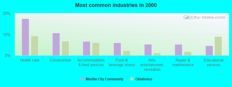
- Health care (17.4%)
- Construction (10.7%)
- Accommodation & food services (6.7%)
- Food & beverage stores (6.0%)
- Arts, entertainment, recreation (5.4%)
- Repair & maintenance (5.4%)
- Educational services (4.7%)
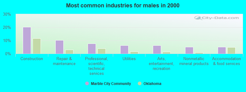
- Construction (20.3%)
- Repair & maintenance (10.1%)
- Professional, scientific, technical services (7.6%)
- Utilities (6.3%)
- Arts, entertainment, recreation (6.3%)
- Nonmetallic mineral products (5.1%)
- Accommodation & food services (5.1%)
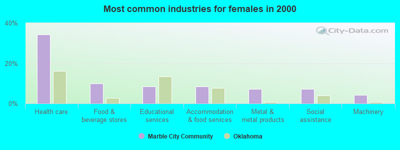
- Health care (34.3%)
- Food & beverage stores (10.0%)
- Educational services (8.6%)
- Accommodation & food services (8.6%)
- Metal & metal products (7.1%)
- Social assistance (7.1%)
- Machinery (4.3%)

- Health technologists and technicians (6.7%)
- Metal workers and plastic workers (6.0%)
- Construction traders workers except carpenters, electricians, painters, plumbers, and construction laborers (5.4%)
- Other sales and related occupations, including supervisors (5.4%)
- Other management occupations, except farmers and farm managers (4.7%)
- Construction laborers (4.7%)
- Retail sales workers, except cashiers (4.7%)

- Construction traders workers except carpenters, electricians, painters, plumbers, and construction laborers (10.1%)
- Construction laborers (8.9%)
- Vehicle and mobile equipment mechanics, installers, and repairers (7.6%)
- Other sales and related occupations, including supervisors (6.3%)
- Top executives (5.1%)
- Building and grounds cleaning and maintenance occupations (5.1%)
- Drafters, engineering, and mapping technicians (5.1%)

- Health technologists and technicians (11.4%)
- Retail sales workers, except cashiers (8.6%)
- Accountants and auditors (7.1%)
- Cashiers (7.1%)
- Metal workers and plastic workers (7.1%)
- Preschool, kindergarten, elementary, and middle school teachers (5.7%)
- Registered nurses (5.7%)
Average climate in Marble City Community, Oklahoma
Based on data reported by over 4,000 weather stations


(lower is better)

Air Quality Index (AQI) level in 2022 was 79.1. This is about average.
| City: | 79.1 |
| U.S.: | 72.6 |

Carbon Monoxide (CO) [ppm] level in 2022 was 0.243. This is about average. Closest monitor was 17.5 miles away from the city center.
| City: | 0.243 |
| U.S.: | 0.251 |

Nitrogen Dioxide (NO2) [ppb] level in 2022 was 5.23. This is about average. Closest monitor was 3.2 miles away from the city center.
| City: | 5.23 |
| U.S.: | 5.11 |

Sulfur Dioxide (SO2) [ppb] level in 2022 was 0.305. This is significantly better than average. Closest monitor was 17.5 miles away from the city center.
| City: | 0.305 |
| U.S.: | 1.515 |

Ozone [ppb] level in 2022 was 30.7. This is about average. Closest monitor was 3.2 miles away from the city center.
| City: | 30.7 |
| U.S.: | 33.3 |

Particulate Matter (PM10) [µg/m3] level in 2022 was 16.4. This is about average. Closest monitor was 3.2 miles away from the city center.
| City: | 16.4 |
| U.S.: | 19.2 |

Particulate Matter (PM2.5) [µg/m3] level in 2022 was 6.94. This is about average. Closest monitor was 3.2 miles away from the city center.
| City: | 6.94 |
| U.S.: | 8.11 |
Tornado activity:
Marble City Community-area historical tornado activity is slightly below Oklahoma state average. It is 113% greater than the overall U.S. average.
On 3/26/1976, a category F5 (max. wind speeds 261-318 mph) tornado 24.3 miles away from the Marble City Community place center killed 2 people and injured 64 people and caused between $500,000 and $5,000,000 in damages.
On 5/5/1960, a category F4 (max. wind speeds 207-260 mph) tornado 5.9 miles away from the place center killed 16 people and injured 106 people and caused between $500,000 and $5,000,000 in damages.
Earthquake activity:
Marble City Community-area historical earthquake activity is significantly above Oklahoma state average. It is 676% greater than the overall U.S. average.On 11/6/2011 at 03:53:10, a magnitude 5.7 (5.7 MW, Depth: 3.2 mi, Class: Moderate, Intensity: VI - VII) earthquake occurred 108.8 miles away from the city center
On 9/3/2016 at 12:02:44, a magnitude 5.8 (5.8 MW, Depth: 3.5 mi) earthquake occurred 132.5 miles away from the city center
On 11/7/2016 at 01:44:24, a magnitude 5.0 (5.0 MW, Depth: 2.8 mi) earthquake occurred 115.0 miles away from the city center
On 11/5/2011 at 07:12:45, a magnitude 4.8 (4.8 MW, Depth: 1.9 mi, Class: Light, Intensity: IV - V) earthquake occurred 108.7 miles away from the city center
On 11/8/2011 at 02:46:57, a magnitude 4.8 (4.8 MW, Depth: 3.1 mi) earthquake occurred 110.1 miles away from Marble City Community center
On 2/28/2011 at 05:00:50, a magnitude 4.7 (4.7 MW, Depth: 2.0 mi) earthquake occurred 140.9 miles away from Marble City Community center
Magnitude types: moment magnitude (MW)
Natural disasters:
The number of natural disasters in Sequoyah County (26) is a lot greater than the US average (15).Major Disasters (Presidential) Declared: 17
Emergencies Declared: 6
Causes of natural disasters: Floods: 15, Storms: 14, Winter Storms: 10, Tornadoes: 9, Winds: 2, Hurricane: 1, Snow: 1, Other: 1 (Note: some incidents may be assigned to more than one category).

Hospitals and medical centers near Marble City Community:
- SOUTHWEST HOME HEALTH CARE (Home Health Center, about 5 miles away; SALLISAW, OK)
- SEQUOYAH MEMORIAL HOSPITAL HOME HEALTH (Home Health Center, about 6 miles away; SALLISAW, OK)
- SEQUOYAH MEMORIAL HOSPITAL Acute Care Hospitals (about 6 miles away; SALLISAW, OK)
- PROFESSIONAL HOME HEALTH (Home Health Center, about 6 miles away; SALLISAW, OK)
- SEQUOYAH MANOR, LLC (Nursing Home, about 6 miles away; SALLISAW, OK)
- LOCAL HOSPICE, INC (Hospital, about 6 miles away; SALLISAW, OK)
- PETERS AGENCY HOME HEALTH SERVICES, L L C (Home Health Center, about 7 miles away; SALLISAW, OK)
Colleges/universities with over 2000 students nearest to Marble City Community:
- Northeastern State University (about 28 miles; Tahlequah, OK; Full-time enrollment: 6,895)
- University of Arkansas-Fort Smith (about 28 miles; Fort Smith, AR; FT enrollment: 6,103)
- Carl Albert State College (about 37 miles; Poteau, OK; FT enrollment: 2,041)
- John Brown University (about 48 miles; Siloam Springs, AR; FT enrollment: 2,097)
- University of Arkansas (about 52 miles; Fayetteville, AR; FT enrollment: 22,163)
- Oklahoma State University Institute of Technology (about 63 miles; Okmulgee, OK; FT enrollment: 3,243)
- NorthWest Arkansas Community College (about 68 miles; Bentonville, AR; FT enrollment: 5,634)
Points of interest:
Churches in Marble City Community include: Blunt Church (A), Dwight Mission (B). Display/hide their locations on the map
Cemeteries: Marble City Cemetery (1), Dwight Cemetery (2). Display/hide their locations on the map
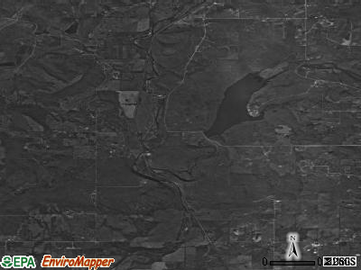
Reservoirs: Brushy Creek Reservoir (A), Sallisaw Creek Site 29 Reservoir (B). Display/hide their locations on the map
Creek: Brushy Creek (A). Display/hide its location on the map
Park in Marble City Community: Sallisaw State Recreation Area (1). Display/hide its location on the map
| This place: | 2.9 people |
| Oklahoma: | 2.5 people |
| This place: | 76.7% |
| Whole state: | 69.1% |
| This place: | 9.6% |
| Whole state: | 4.0% |
Likely homosexual households (counted as self-reported same-sex unmarried-partner households)
- Lesbian couples: 1.4% of all households
- Gay men: 0.7% of all households
| This place: | 23.9% |
| Whole state: | 14.7% |
| This place: | 6.3% |
| Whole state: | 6.1% |
For population 15 years and over in Marble City Community:

- Never married: 18.8%
- Now married: 61.4%
- Separated: 2.4%
- Widowed: 3.4%
- Divorced: 14.0%
For population 25 years and over in Marble City Community:
- High school or higher: 72.4%
- Bachelor's degree or higher: 8.9%
- Graduate or professional degree: 1.2%
- Unemployed: 5.7%
- Mean travel time to work (commute): 39.7 minutes


| Here: | 9.4 |
| Oklahoma average: | 11.7 |
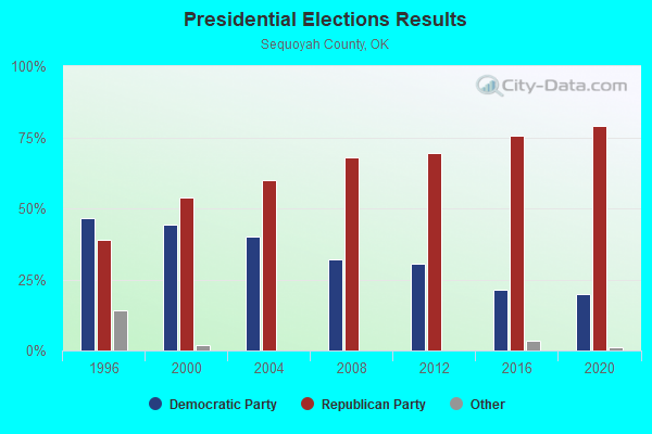
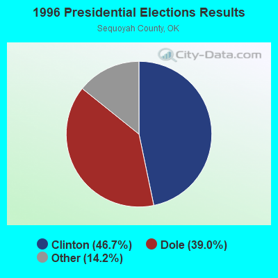
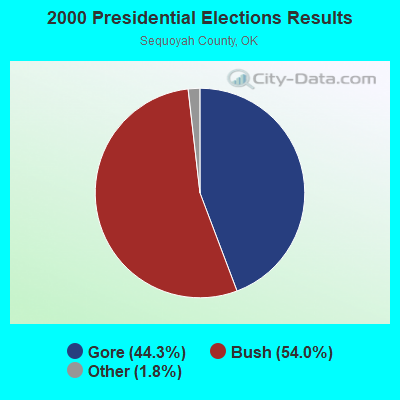
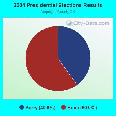
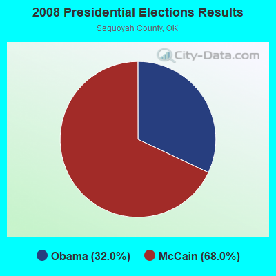
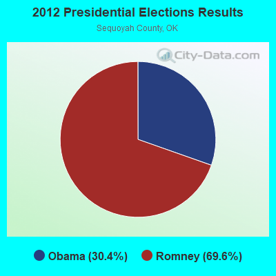
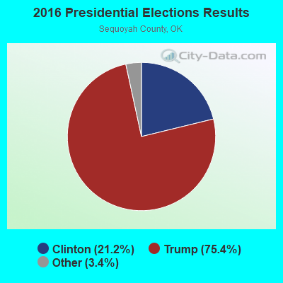
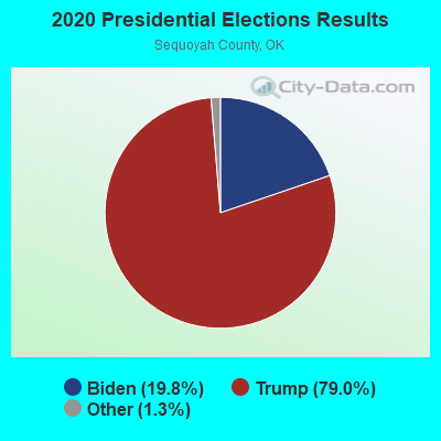
Graphs represent county-level data. Detailed 2008 Election Results
Religion statistics for Marble City Community, OK (based on Sequoyah County data)
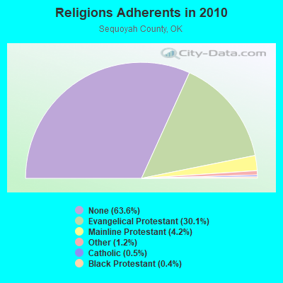
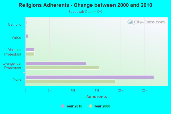
| Religion | Adherents | Congregations |
|---|---|---|
| Evangelical Protestant | 12,746 | 75 |
| Mainline Protestant | 1,791 | 6 |
| Other | 492 | 3 |
| Catholic | 220 | 2 |
| Black Protestant | 187 | 1 |
| None | 26,955 | - |
Food Environment Statistics:
| Sequoyah County: | 1.95 / 10,000 pop. |
| State: | 1.97 / 10,000 pop. |
| Sequoyah County: | 0.24 / 10,000 pop. |
| Oklahoma: | 0.20 / 10,000 pop. |
| This county: | 0.73 / 10,000 pop. |
| Oklahoma: | 0.76 / 10,000 pop. |
| Sequoyah County: | 5.86 / 10,000 pop. |
| Oklahoma: | 4.35 / 10,000 pop. |
| This county: | 4.89 / 10,000 pop. |
| State: | 6.89 / 10,000 pop. |
| Sequoyah County: | 11.9% |
| Oklahoma: | 10.3% |
| Sequoyah County: | 31.6% |
| Oklahoma: | 29.2% |
Strongest AM radio stations in Marble City Community:
- KYHN (1320 AM; 10 kW; FORT SMITH, AR; Owner: CAPSTAR TX LIMITED PARTNERSHIP)
- KFAQ (1170 AM; 50 kW; TULSA, OK; Owner: JOURNAL BROADCAST CORPORATION)
- KRMG (740 AM; 50 kW; TULSA, OK; Owner: CXR HOLDINGS, INC.)
- KWHN (1650 AM; 10 kW; FT. SMITH, AR; Owner: CAPSTAR TX LIMITED PARTNERSHIP)
- KFAY (1030 AM; 10 kW; FARMINGTON, AR; Owner: CUMULUS LICENSING CORP)
- KKUZ (1560 AM; daytime; 0 kW; SALLISAW, OK; Owner: TEDDY BEAR COMMUNICATIONS, INC.)
- KTBZ (1430 AM; 25 kW; TULSA, OK; Owner: CLEAR CHANNEL BROADCASTING LICENSES, INC.)
- KGHT (880 AM; 50 kW; SHERIDAN, AR; Owner: METROPOLITAN RADIO GROUP, INC.)
- KFSA (950 AM; 1 kW; FORT SMITH, AR; Owner: FRED H. BAKER, SR.)
- KMUS (1380 AM; 20 kW; MUSKOGEE, OK; Owner: ABC, INC.)
- KAAY (1090 AM; 50 kW; LITTLE ROCK, AR; Owner: CITADEL BROADCASTING COMPANY)
- KUOA (1290 AM; 5 kW; SILOAM SPRINGS, AR; Owner: KUOA, INC.)
- KEEL (710 AM; 50 kW; SHREVEPORT, LA; Owner: CITICASTERS LICENSES, L.P.)
Strongest FM radio stations in Marble City Community:
- KKBD (95.9 FM; SALLISAW, OK; Owner: CAPSTAR TX LIMITED PARTNERSHIP)
- KZBB (97.9 FM; POTEAU, OK; Owner: CAPSTAR TX LIMITED PARTNERSHIP)
- KMAG (99.1 FM; FORT SMITH, AR; Owner: CAPSTAR TX LIMITED PARTNERSHIP)
- KTCS-FM (99.9 FM; FORT SMITH, AR; Owner: BIG CHIEF BROADCASTING COMPANY)
- K204EW (88.7 FM; POTEAU, OK; Owner: CALVARY CHAPEL OF TWIN FALLS, INC.)
- K219CN (91.7 FM; POTEAU, OK; Owner: AMERICAN FAMILY ASSOCIATION)
- KARG (91.7 FM; POTEAU, OK; Owner: AMERICAN FAMILY ASSOCIATION)
- KISR (93.7 FM; FORT SMITH, AR; Owner: STEREO 93, INC.)
- KREU (92.3 FM; ROLAND, OK; Owner: STAR 92 CO.)
- KOMS (107.3 FM; POTEAU, OK; Owner: CUMULUS LICENSING CORP.)
- KMMY (97.1 FM; MUSKOGEE, OK; Owner: KMMY, Inc.)
- KTKL (88.5 FM; STIGLER, OK; Owner: EDUCATIONAL MEDIA FOUNDATION)
- KDAB (94.9 FM; PRAIRIE GROVE, AR; Owner: CUMULUS LICENSING CORP.)
- KLSZ-FM (102.7 FM; VAN BUREN, AR; Owner: CUMULUS LICENSING CORP.)
- KAOW (88.9 FM; FORT SMITH, AR; Owner: AMERICAN FAMILY ASSOCIATION)
- K209CA (89.7 FM; VAN BUREN, AR; Owner: BIBLE BROADCASTING NETWORK, INC.)
TV broadcast stations around Marble City Community:
- KFSM-TV (Channel 5; FORT SMITH, AR; Owner: NEW YORK TIMES MANAGEMENT SERVICES)
- K48FL (Channel 48; FORT SMITH, AR; Owner: TV 34, INC.)
- KTUL (Channel 8; TULSA, OK; Owner: KTUL, LLC)
- KOTV (Channel 6; TULSA, OK; Owner: GRIFFIN LICENSING, L.L.C.)
Marble City Community fatal accident list:
Jun 16, 2019 06:35 AM, Cr-4620, Lat: 35.521300, Lon: -94.796500, Vehicles: 1, Persons: 1, Fatalities: 1
Aug 5, 2005 03:30 AM, No Name, Lat: 35.557950, Lon: -94.827110, Vehicles: 1, Persons: 3, Fatalities: 1, Drunk persons involved: 1
- National Bridge Inventory (NBI) Statistics
- 4Number of bridges
- 69ft / 20.8mTotal length
- $1,403,000Total costs
- 3,985Total average daily traffic
- 592Total average daily truck traffic
- 4,997Total future (year 2040) average daily traffic
| Home Mortgage Disclosure Act Aggregated Statistics For Year 2009 (Based on 1 partial tract) | ||||
| B) Conventional Home Purchase Loans | C) Refinancings | |||
|---|---|---|---|---|
| Number | Average Value | Number | Average Value | |
| LOANS ORIGINATED | 1 | $69,400 | 2 | $97,035 |
| APPLICATIONS APPROVED, NOT ACCEPTED | 0 | $0 | 0 | $0 |
| APPLICATIONS DENIED | 0 | $0 | 0 | $0 |
| APPLICATIONS WITHDRAWN | 0 | $0 | 0 | $0 |
| FILES CLOSED FOR INCOMPLETENESS | 0 | $0 | 0 | $0 |
Detailed HMDA statistics for the following Tracts: 0301.01


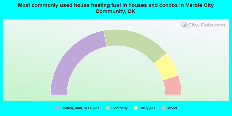
- 43.9%Bottled, tank, or LP gas
- 34.2%Electricity
- 12.3%Utility gas
- 9.6%Wood
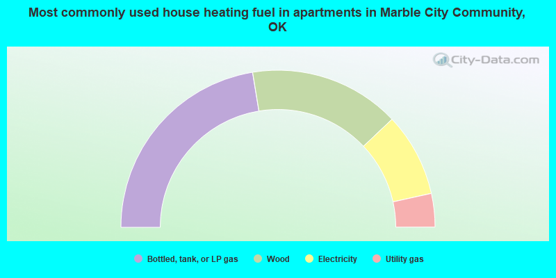
- 44.8%Bottled, tank, or LP gas
- 31.0%Wood
- 17.2%Electricity
- 6.9%Utility gas
Marble City Community compared to Oklahoma state average:
- Median house value below state average.
- Unemployed percentage below state average.
- Black race population percentage significantly below state average.
- Hispanic race population percentage significantly below state average.
- Foreign-born population percentage significantly below state average.
- Renting percentage significantly below state average.
- Length of stay since moving in significantly above state average.
- Number of rooms per house significantly below state average.
- House age significantly below state average.
- Number of college students significantly below state average.
- Percentage of population with a bachelor's degree or higher below state average.