Hartsville, New York
Hartsville: Fall Creek, Hartsville, NY

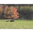
Hartsville: Hartsville, NY, Valley
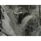
Hartsville: Fall in Hartsville, NY
- add
your
Submit your own pictures of this town and show them to the world
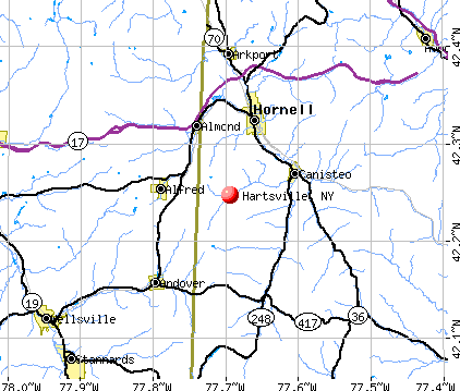
- OSM Map
- General Map
- Google Map
- MSN Map
Population change since 2000: +4.1%
 |
| Males: 328 | |
| Females: 281 |
| Median resident age: | 45.5 years |
| New York median age: | 40.7 years |
Zip codes: 14843.
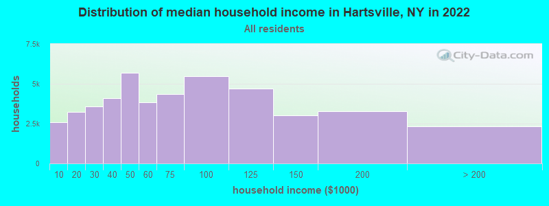
| Hartsville: | $68,839 |
| NY: | $79,557 |
Estimated per capita income in 2022: $33,626 (it was $17,667 in 2000)
Hartsville town income, earnings, and wages data
Estimated median house or condo value in 2022: $104,433 (it was $53,100 in 2000)
| Hartsville: | $104,433 |
| NY: | $400,400 |
Mean prices in 2022: all housing units: $169,714; detached houses: $184,786; townhouses or other attached units: $138,888; in 2-unit structures: $291,252; in 3-to-4-unit structures: $333,918; in 5-or-more-unit structures: $308,305; mobile homes: $80,148; occupied boats, rvs, vans, etc.: $43,655
Detailed information about poverty and poor residents in Hartsville, NY
Compare current foreclosures near Hartsville, NY:
| Photo | Address | Area | Beds / Baths | Price | Details |
|---|---|---|---|---|---|

|
#1
Vandermark Rd
Scio, NY 14880
|
- sq. feet
|
1 baths 3 beds |
$34,900
|
show details |

|
#2
E Elm St
Hornell, NY 14843
|
1,784 sq. feet
|
1 baths 3 beds |
show details | |

|
#3
Leach Ave
Hornell, NY 14843
|
1,248 sq. feet
|
1 baths 3 beds |
show details | |

|
#4
N Main St
Hornell, NY 14843
|
1,020 sq. feet
|
2 baths 2 beds |
show details | |

|
#5
Elmwood Pl
Hornell, NY 14843
|
1,143 sq. feet
|
1 baths 2 beds |
show details | |

|
#6
County Route 10
Cameron, NY 14819
|
1,554 sq. feet
|
1 baths 3 beds |
show details | |

|
#7
Main St
Almond, NY 14804
|
1,848 sq. feet
|
2 baths 3 beds |
show details | |

|
#8
Hill St
Hornell, NY 14843
|
1,846 sq. feet
|
2 baths 4 beds |
show details | |

|
#9
Hill St
Hornell, NY 14843
|
2,146 sq. feet
|
2 baths 3 beds |
show details | |

|
#10
County Route 21
Canisteo, NY 14823
|
1,296 sq. feet
|
1 baths 3 beds |
show details |
| Photo | Address | Area | Beds / Baths | Price | Details |
|---|---|---|---|---|---|

|
#11
4th St
Hornell, NY 14843
|
1,122 sq. feet
|
1 baths 2 beds |
show details | |

|
#12
County Route 123
Jasper, NY 14855
|
1,066 sq. feet
|
1 baths 3 beds |
show details | |

|
#13
Mcchesney Rd
Bath, NY 14810
|
1,960 sq. feet
|
2 baths 3 beds |
show details | |

|
#14
Spring St
Canisteo, NY 14823
|
1,730 sq. feet
|
1 baths 3 beds |
show details | |

|
#15
Maple St
Canisteo, NY 14823
|
1,416 sq. feet
|
2 baths 3 beds |
show details | |

|
#16
Crittenden Rd
Hornell, NY 14843
|
2,363 sq. feet
|
1 baths 4 beds |
show details | |

|
#17
Crescent Dr
Wellsville, NY 14895
|
1,075 sq. feet
|
1 baths 3 beds |
show details | |

|
#18
Hallsport Independence Rd
Andover, NY 14806
|
2,208 sq. feet
|
2 baths 3 beds |
show details | |

|
#19
Ricks Rd
Hornell, NY 14843
|
1,296 sq. feet
|
1 baths 3 beds |
show details | |

|
#20
Fulton St
Hornell, NY 14843
|
2,664 sq. feet
|
1 baths 4 beds |
show details |
| Photo | Address | Area | Beds / Baths | Price | Details |
|---|---|---|---|---|---|

|
#21
Fulton St
Hornell, NY 14843
|
1,280 sq. feet
|
1 baths 3 beds |
show details | |

|
#22
Clark Rd
Alfred Station, NY 14803
|
2,520 sq. feet
|
2 baths 4 beds |
show details | |

|
#23
Williams Ave
Wellsville, NY 14895
|
1,207 sq. feet
|
1 baths 3 beds |
show details | |

|
#24
E Pearl St
Wellsville, NY 14895
|
2,839 sq. feet
|
2 baths 4 beds |
show details | |

|
#25
Trapping Brook Rd
Wellsville, NY 14895
|
- sq. feet
|
2 baths 3 beds |
show details | |

|
#26
County Route 84
Troupsburg, NY 14885
|
- sq. feet
|
- baths - beds |
show details | |

|
#27
Oak Hill Rd
Arkport, NY 14807
|
- sq. feet
|
- baths - beds |
show details | |

|
#28
Clark Rd
Alfred Station, NY 14803
|
- sq. feet
|
- baths - beds |
show details | |

|
#29
Hallsport Rd
Wellsville, NY 14895
|
- sq. feet
|
- baths - beds |
show details | |

|
#30
Stone School Rd
Bath, NY 14810
|
1,568 sq. feet
|
- baths - beds |
show details |
| Photo | Address | Area | Beds / Baths | Price | Details |
|---|---|---|---|---|---|

|
#31
Preston Ave # 201
Hornell, NY 14843
|
- sq. feet
|
- baths - beds |
show details | |

|
#32
Elm St
Canisteo, NY 14823
|
- sq. feet
|
- baths - beds |
show details | |

|
#33
Lynch Rd
Andover, NY 14806
|
- sq. feet
|
- baths - beds |
show details | |

|
#34
Orchard St
Canisteo, NY 14823
|
- sq. feet
|
- baths - beds |
show details | |

|
#35
Lyon Rd
Woodhull, NY 14898
|
- sq. feet
|
- baths - beds |
show details | |

|
Check over 1 million property listings on Foreclosure.com!
|
browse all offers | |||

- 60198.7%White alone
- 30.5%Two or more races
- 30.5%Hispanic
- 10.2%Black alone
- 10.2%American Indian alone
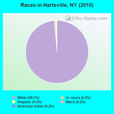
Races in Hartsville detailed stats: ancestries, foreign born residents, place of birth
 Recent articles from our blog. Our writers, many of them Ph.D. graduates or candidates, create easy-to-read articles on a wide variety of topics.

 | The Positive in WNY (92 replies) |
| Schoharie County Wind Farm Notification (45 replies) |
Latest news from Hartsville, NY collected exclusively by city-data.com from local newspapers, TV, and radio stations
Ancestries: Irish (18.8%), English (18.6%), German (16.8%), United States (14.9%), Italian (5.8%), Dutch (4.8%).
Current Local Time: EST time zone
Elevation: 1484 feet
Land area: 36.2 square miles.
Population density: 17 people per square mile (very low).
7 residents are foreign born
| This town: | 1.2% |
| New York: | 20.4% |
| Hartsville town: | 1.6% ($855) |
| New York: | 1.9% ($2,847) |
Nearest city with pop. 50,000+: Rochester, NY  (63.6 miles , pop. 219,773).
Nearest city with pop. 1,000,000+: Philadelphia, PA (204.5 miles , pop. 1,517,550).
Nearest cities:
), ), ), ), ), ), )Latitude: 42.25 N, Longitude: 77.69 W
Area code commonly used in this area: 607

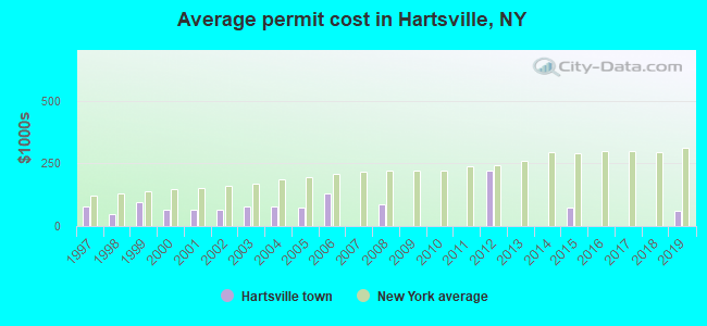
Single-family new house construction building permits:
- 2019: 1 building, cost: $60,000
- 2015: 1 building, cost: $75,000
- 2012: 3 buildings, average cost: $220,000
- 2008: 1 building, cost: $86,000
- 2006: 1 building, cost: $132,000
- 2005: 3 buildings, average cost: $73,300
- 2004: 1 building, cost: $78,000
- 2003: 1 building, cost: $78,000
- 2002: 5 buildings, average cost: $66,200
- 2001: 5 buildings, average cost: $66,200
- 2000: 5 buildings, average cost: $66,200
- 1999: 1 building, cost: $95,000
- 1998: 1 building, cost: $46,000
- 1997: 2 buildings, average cost: $80,000
| Here: | 4.5% |
| New York: | 4.4% |
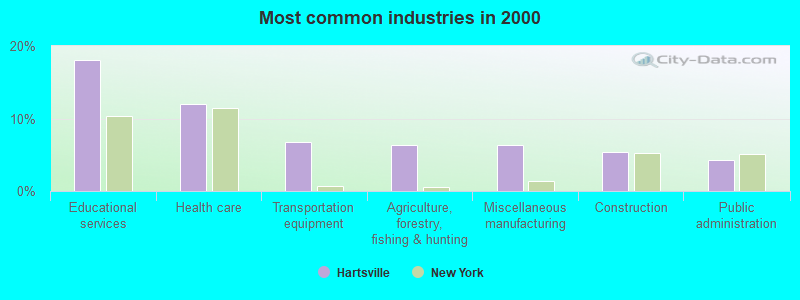
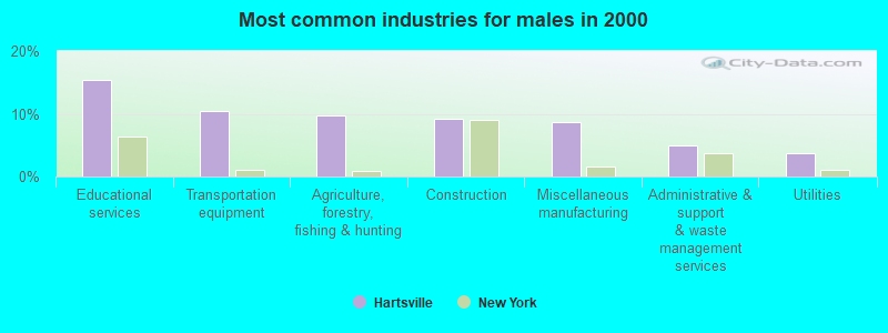
- Educational services (18.1%)
- Health care (12.1%)
- Transportation equipment (6.7%)
- Agriculture, forestry, fishing & hunting (6.4%)
- Miscellaneous manufacturing (6.4%)
- Construction (5.3%)
- Public administration (4.3%)
- Educational services (15.3%)
- Transportation equipment (10.4%)
- Agriculture, forestry, fishing & hunting (9.8%)
- Construction (9.2%)
- Miscellaneous manufacturing (8.6%)
- Administrative & support & waste management services (4.9%)
- Utilities (3.7%)
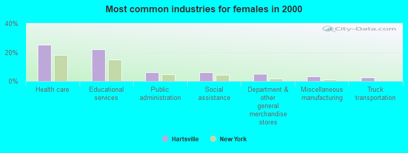
- Health care (25.2%)
- Educational services (21.8%)
- Public administration (5.9%)
- Social assistance (5.9%)
- Department & other general merchandise stores (5.0%)
- Miscellaneous manufacturing (3.4%)
- Truck transportation (2.5%)
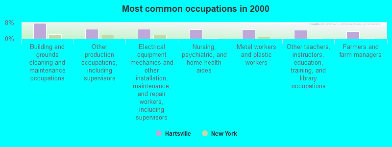
- Building and grounds cleaning and maintenance occupations (7.8%)
- Other production occupations, including supervisors (5.0%)
- Electrical equipment mechanics and other installation, maintenance, and repair workers, including supervisors (5.0%)
- Nursing, psychiatric, and home health aides (4.6%)
- Metal workers and plastic workers (4.6%)
- Other teachers, instructors, education, training, and library occupations (4.3%)
- Farmers and farm managers (3.5%)
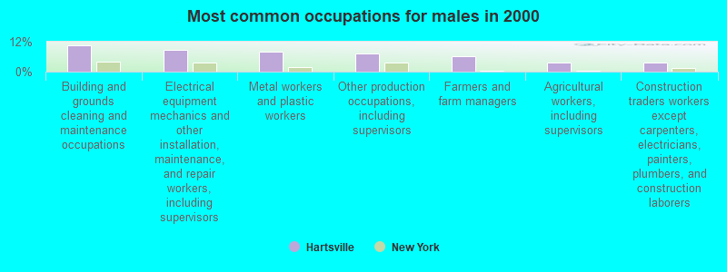
- Building and grounds cleaning and maintenance occupations (10.4%)
- Electrical equipment mechanics and other installation, maintenance, and repair workers, including supervisors (8.6%)
- Metal workers and plastic workers (8.0%)
- Other production occupations, including supervisors (7.4%)
- Farmers and farm managers (6.1%)
- Agricultural workers, including supervisors (3.7%)
- Construction traders workers except carpenters, electricians, painters, plumbers, and construction laborers (3.7%)
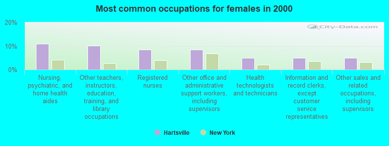
- Nursing, psychiatric, and home health aides (10.9%)
- Other teachers, instructors, education, training, and library occupations (10.1%)
- Registered nurses (8.4%)
- Other office and administrative support workers, including supervisors (8.4%)
- Health technologists and technicians (5.0%)
- Information and record clerks, except customer service representatives (5.0%)
- Other sales and related occupations, including supervisors (5.0%)
Average climate in Hartsville, New York
Based on data reported by over 4,000 weather stations


Tornado activity:
Hartsville-area historical tornado activity is near New York state average. It is 63% smaller than the overall U.S. average.
On 6/20/1969, a category F3 (max. wind speeds 158-206 mph) tornado 19.0 miles away from the Hartsville town center caused between $500,000 and $5,000,000 in damages.
On 7/21/2003, a category F3 tornado 25.7 miles away from the town center caused $200,000 in damages.
Earthquake activity:
Hartsville-area historical earthquake activity is significantly above New York state average. It is 66% smaller than the overall U.S. average.On 9/25/1998 at 19:52:52, a magnitude 5.2 (4.8 MB, 4.3 MS, 5.2 LG, 4.5 MW, Depth: 3.1 mi, Class: Moderate, Intensity: VI - VII) earthquake occurred 148.7 miles away from the city center
On 8/23/2011 at 17:51:04, a magnitude 5.8 (5.8 MW, Depth: 3.7 mi) earthquake occurred 300.3 miles away from the city center
On 10/7/1983 at 10:18:46, a magnitude 5.3 (5.1 MB, 5.3 LG, 5.1 ML) earthquake occurred 206.3 miles away from Hartsville center
On 1/31/1986 at 16:46:43, a magnitude 5.0 (5.0 MB) earthquake occurred 183.9 miles away from the city center
On 4/20/2002 at 10:50:47, a magnitude 5.3 (5.3 ML, Depth: 3.0 mi) earthquake occurred 254.7 miles away from the city center
On 4/20/2002 at 10:50:47, a magnitude 5.2 (5.2 MB, 4.2 MS, 5.2 MW, 5.0 MW) earthquake occurred 252.8 miles away from the city center
Magnitude types: regional Lg-wave magnitude (LG), body-wave magnitude (MB), local magnitude (ML), surface-wave magnitude (MS), moment magnitude (MW)
Natural disasters:
The number of natural disasters in Steuben County (20) is greater than the US average (15).Major Disasters (Presidential) Declared: 16
Emergencies Declared: 4
Causes of natural disasters: Storms: 12, Floods: 10, Hurricanes: 2, Tornadoes: 2, Blizzard: 1, Flash Flood: 1, Heavy Rain: 1, Landslide: 1, Power Outage: 1, Tropical Depression: 1, Tropical Storm: 1, Wind: 1, Winter Storm: 1, Other: 1 (Note: some incidents may be assigned to more than one category).
Hospitals and medical centers near Hartsville:
- HORNELL GARDENS (Nursing Home, about 5 miles away; HORNELL, NY)
- ST JAMES MERCY HOSPITAL Acute Care Hospitals (about 5 miles away; HORNELL, NY)
- ST. JAMES MERCY HOSPITAL (Dialysis Facility, about 7 miles away; HORNELL, NY)
- JONES MEMORIAL HOSPITAL Acute Care Hospitals (about 16 miles away; WELLSVILLE, NY)
Colleges/universities with over 2000 students nearest to Hartsville:
- Alfred University (about 5 miles; Alfred, NY; Full-time enrollment: 2,411)
- SUNY College of Technology at Alfred (about 6 miles; Alfred, NY; FT enrollment: 3,483)
- Corning Community College (about 33 miles; Corning, NY; FT enrollment: 3,036)
- SUNY College at Geneseo (about 39 miles; Geneseo, NY; FT enrollment: 5,520)
- St Bonaventure University (about 42 miles; Saint Bonaventure, NY; FT enrollment: 2,286)
- Mansfield University of Pennsylvania (about 45 miles; Mansfield, PA; FT enrollment: 2,826)
- Finger Lakes Community College (about 49 miles; Canandaigua, NY; FT enrollment: 4,732)
Points of interest:
Notable location: Stephens Tree Farm (A). Display/hide its location on the map
Church in Hartsville: Hartsville Church (A). Display/hide its location on the map
Cemeteries: Hartsville Center Cemetery (1), Hartsville Hill Cemetery (2), Call Hill Cemetery (3). Display/hide their locations on the map
| This town: | 2.5 people |
| New York: | 2.6 people |
| This town: | 70.2% |
| Whole state: | 63.5% |
| This town: | 8.6% |
| Whole state: | 6.8% |
Likely homosexual households (counted as self-reported same-sex unmarried-partner households)
- Lesbian couples: 1.2% of all households
- Gay men: 0.0% of all households
| This town: | 12.3% |
| Whole state: | 14.6% |
| This town: | 2.7% |
| Whole state: | 7.4% |
For population 15 years and over in Hartsville:
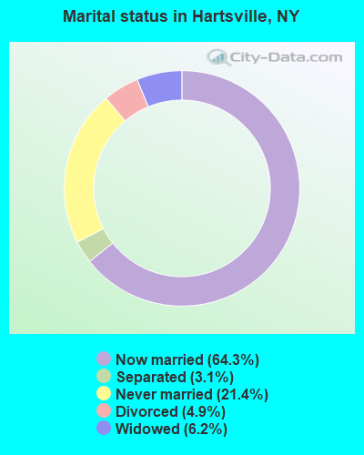
- Never married: 21.4%
- Now married: 64.3%
- Separated: 3.1%
- Widowed: 6.2%
- Divorced: 4.9%
For population 25 years and over in Hartsville:
- High school or higher: 78.4%
- Bachelor's degree or higher: 12.7%
- Graduate or professional degree: 7.1%
- Unemployed: 7.5%
- Mean travel time to work (commute): 27.5 minutes
| Here: | 11.5 |
| New York average: | 14.2 |
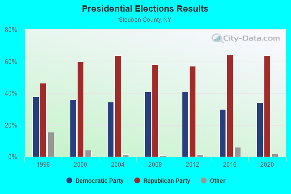
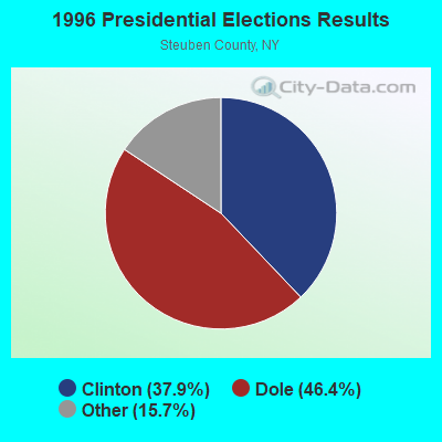
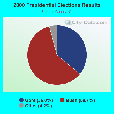
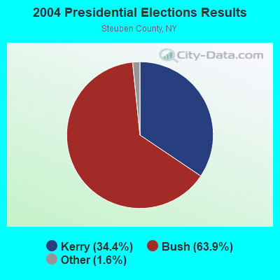
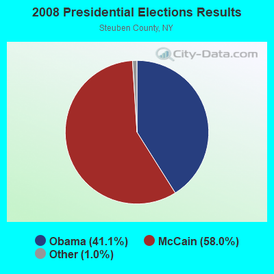
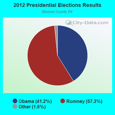
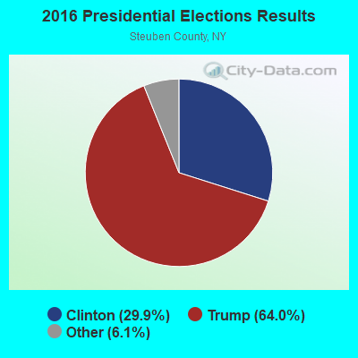
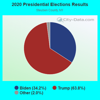
Graphs represent county-level data. Detailed 2008 Election Results
Religion statistics for Hartsville, NY (based on Steuben County data)
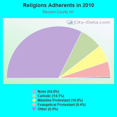
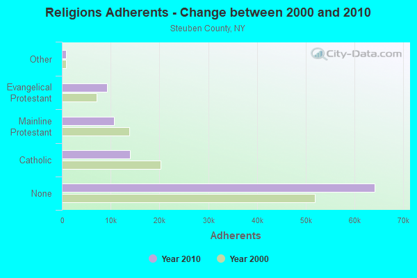
| Religion | Adherents | Congregations |
|---|---|---|
| Catholic | 13,963 | 11 |
| Mainline Protestant | 10,652 | 70 |
| Evangelical Protestant | 9,272 | 72 |
| Other | 857 | 8 |
| Orthodox | 65 | 1 |
| None | 64,181 | - |
Food Environment Statistics:
| Here: | 2.48 / 10,000 pop. |
| New York: | 4.13 / 10,000 pop. |
| Steuben County: | 0.10 / 10,000 pop. |
| State: | 0.06 / 10,000 pop. |
| This county: | 0.72 / 10,000 pop. |
| New York: | 0.92 / 10,000 pop. |
| Steuben County: | 4.24 / 10,000 pop. |
| New York: | 1.68 / 10,000 pop. |
| Steuben County: | 9.00 / 10,000 pop. |
| State: | 8.82 / 10,000 pop. |
| This county: | 10.2% |
| New York: | 8.2% |
| Steuben County: | 28.3% |
| State: | 23.8% |
| Steuben County: | 14.2% |
| State: | 15.6% |
Strongest AM radio stations in Hartsville:
- WHHO (1320 AM; 5 kW; HORNELL, NY; Owner: BILBAT RADIO, INC.)
- WLEA (1480 AM; 2 kW; HORNELL, NY; Owner: PMJ COMMUNICATIONS, INC.)
- WABH (1380 AM; 10 kW; BATH, NY)
- WHAM (1180 AM; 50 kW; ROCHESTER, NY; Owner: CITICASTERS LICENSES, L.P.)
- WWKB (1520 AM; 50 kW; BUFFALO, NY; Owner: ENTERCOM BUFFALO LICENSE, LLC)
- WLSV (790 AM; 1 kW; WELLSVILLE, NY; Owner: DBM COMMUNICATIONS, INC.)
- WLNL (1000 AM; daytime; 5 kW; HORSEHEADS, NY; Owner: LIGHTHOUSE MEDIA, INC.)
- WWLZ (820 AM; 4 kW; HORSEHEADS, NY; Owner: CHEMUNG COUNTY RADIO, INC.)
- WWJZ (640 AM; 50 kW; MOUNT HOLLY, NJ; Owner: ABC, INC.)
- WFLR (1570 AM; 5 kW; DUNDEE, NY; Owner: LAKES COUNTY COMMUNICATION CORP.)
- WMCA (570 AM; 50 kW; NEW YORK, NY; Owner: SALEM MEDIA OF NEW YORK, LLC)
- WDNY (1400 AM; 1 kW; DANSVILLE, NY; Owner: MILLER MEDIA INC)
- KDKA (1020 AM; 50 kW; PITTSBURGH, PA; Owner: INFINITY BROADCASTING OPERATIONS, INC.)
Strongest FM radio stations in Hartsville:
- WKPQ (105.3 FM; HORNELL, NY; Owner: BILBAT RADIO, INC.)
- WSQA (88.7 FM; HORNELL, NY; Owner: WSKG PUBLIC TELECOMMUNICATIONS COUNCIL)
- W257AX (99.3 FM; HORNELL, NY; Owner: FAMILY LIFE MINISTRIES, INC.)
- WZKZ (101.9 FM; ALFRED, NY; Owner: PEMBROOK PINES ELMIRA, LTD.)
- WCKR (92.1 FM; HORNELL, NY; Owner: PMJ COMMUNICATIONS, INC.)
- WETD (90.7 FM; ALFRED, NY; Owner: STATE UNIVERSITY OF NEW YORK)
- WCIK (103.1 FM; BATH, NY; Owner: FAMILY LIFE MINISTRIES, INC.)
- WDNY-FM (93.9 FM; DANSVILLE, NY; Owner: MILLER MEDIA INC.)
- W201CY (88.1 FM; DANSVILLE, NY; Owner: MARS HILL BROADCASTING CO., INC.)
- W246AP (97.1 FM; DANSVILLE, NY; Owner: CALVARY CHAPEL OF THE FINGER LAKES)
- W282AC (104.3 FM; DANSVILLE, NY; Owner: FAMILY LIFE MINISTRIES, INC.)
- WJQZ (103.5 FM; WELLSVILLE, NY; Owner: DBM COMMUNICATIONS, INC.)
- WCIY (88.9 FM; CANANDAIGUA, NY; Owner: FAMILY LIFE MINISTRIES, INC.)
- WFXF (107.3 FM; SOUTH BRISTOL TOWNSH, NY; Owner: CITICASTERS LICENSES, L.P.)
- WNVE (95.1 FM; HONEOYE FALLS, NY; Owner: CITICASTERS LICENSES, L.P.)
- WVIN-FM (98.3 FM; BATH, NY; Owner: PEMBROOK PINES MASS MEDIA, NA CORP.)
- WGMM (97.7 FM; BIG FLATS, NY; Owner: EOLIN BROADCASTING, INC.)
- WCBA-FM (98.7 FM; CORNING, NY; Owner: EOLIN BROADCASTING, INC.)
- WCID (89.1 FM; FRIENDSHIP, NY; Owner: FAMILY LIFE MINISTRIES, INC.)
- WMTT (94.7 FM; TIOGA, PA; Owner: EUROPA COMMUNICATIONS, INC.)
TV broadcast stations around Hartsville:
- W16BE (Channel 16; HORNELL, NY; Owner: WYDC, INC.)
- W06AR (Channel 6; HORNELL, NY; Owner: LILLY BROADCASTING, L.L.C.)
- W60AD (Channel 60; SAVONA, NY; Owner: WSKG PUBLIC TELECOMMUNICATIONS COUNCIL)
- National Bridge Inventory (NBI) Statistics
- 20Number of bridges
- 85ft / 25.7mTotal length
- $14,316,000Total costs
- 5,448Total average daily traffic
- 242Total average daily truck traffic
- 7,457Total future (year 2036) average daily traffic
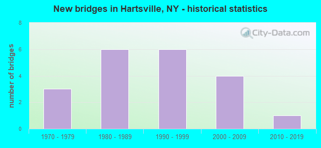
- New bridges - historical statistics
- 31970-1979
- 61980-1989
- 61990-1999
- 42000-2009
- 12010-2019
FCC Registered Antenna Towers:
1- Hinkley Hill (Lat: 42.267222 Lon: -77.631667), Type: 97.8, Overall height: 91.4 m, Registrant: Wskg Public Telecommunications Council Dba , Mark_polovick@wskg.Pbs.Org, , Vesta-l, Phone: (607) 729-0100
FCC Registered Microwave Towers:
1- Call Hill, 2.37 Mi S Of (Lat: 42.213694 Lon: -77.693056), Type: Ltower, Structure height: 52 m, Call Sign: KDT80,
Assigned Frequencies: 6655.00 MHz, 6645.00 MHz, 6665.00 MHz, 5945.20 MHz, 5974.85 MHz, 5945.20 MHz, 5974.85 MHz, 5945.20 MHz, 5974.85 MHz, 5945.20 MHz... (+17 more), Grant Date: 07/23/2019, Expiration Date: 08/01/2029, Registrant: Eastern Gas Transmission And Storage, Inc., 925 White Oaks Blvd., Bridgeport, WV 26330, Phone: (681) 842-3701, Email:
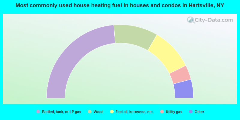
- 47.3%Bottled, tank, or LP gas
- 19.5%Wood
- 18.6%Fuel oil, kerosene, etc.
- 6.4%Utility gas
- 3.2%Coal or coke
- 2.7%Electricity
- 2.3%Other fuel
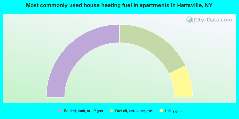
- 50.0%Bottled, tank, or LP gas
- 35.7%Fuel oil, kerosene, etc.
- 14.3%Utility gas
Hartsville compared to New York state average:
- Median house value significantly below state average.
- Unemployed percentage below state average.
- Black race population percentage significantly below state average.
- Hispanic race population percentage significantly below state average.
- Median age above state average.
- Foreign-born population percentage significantly below state average.
- Renting percentage significantly below state average.
- Length of stay since moving in significantly above state average.
- Number of rooms per house significantly below state average.
- House age significantly below state average.
- Number of college students significantly below state average.
- Percentage of population with a bachelor's degree or higher below state average.