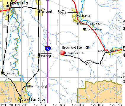
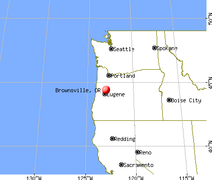
Brownsville, Oregon

Brownsville: Sunset
Brownsville: Coke Painting, Brownsville, Oregon
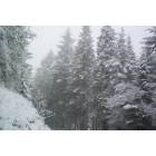
Brownsville: Winter 2006
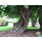
Brownsville: Braided Tree, Brownsville, Oregon
Brownsville: Brownsville Cemetery, Brownsville, Oregon
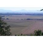
Brownsville: The view from my house of Brownsville
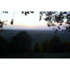
Brownsville: Sunset

Brownsville: resident of Pioneer park
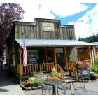
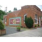
Brownsville: Randy's Main Street Coffee
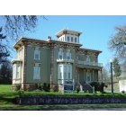
Brownsville: Moyer house
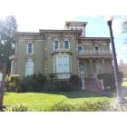
Brownsville: Moyer House
- see
18
more - add
your
Submit your own pictures of this city and show them to the world
- OSM Map
- General Map
- Google Map
- MSN Map
Population change since 2000: +27.1%
 |
| Males: 890 | |
| Females: 952 |
| Median resident age: | 44.3 years |
| Oregon median age: | 40.5 years |
Zip codes: 97327.
| Brownsville: | $75,515 |
| OR: | $75,657 |
Estimated per capita income in 2022: $37,945 (it was $15,272 in 2000)
Brownsville city income, earnings, and wages data
Estimated median house or condo value in 2022: $348,282 (it was $117,800 in 2000)
| Brownsville: | $348,282 |
| OR: | $475,600 |
Mean prices in 2022: all housing units: $253,338; detached houses: $286,524; mobile homes: $85,111
Median gross rent in 2022: $1,486.
(6.6% for White Non-Hispanic residents, 31.8% for American Indian residents, 2.2% for two or more races residents)
Detailed information about poverty and poor residents in Brownsville, OR
Compare current foreclosures near Brownsville, OR:
| Photo | Address | Area | Beds / Baths | Price | Details |
|---|---|---|---|---|---|

|
#1
Kay Ave
Brownsville, OR 97327
|
1,056 sq. feet
|
1 baths 3 beds |
show details | |

|
#2
Northpoint Loop
Brownsville, OR 97327
|
- sq. feet
|
- baths - beds |
show details | |

|
#3
Blakely Ave
Brownsville, OR 97327
|
- sq. feet
|
- baths - beds |
show details | |

|
#4
Liberty Rd
Sweet Home, OR 97386
|
2,739 sq. feet
|
3 baths 4 beds |
show details | |

|
#5
Cougar Ave SW
Albany, OR 97321
|
1,433 sq. feet
|
2 baths 3 beds |
show details | |

|
#6
Elm St
Junction City, OR 97448
|
- sq. feet
|
2 baths 3 beds |
show details | |

|
#7
Toftdahl Rd
Junction City, OR 97448
|
1,712 sq. feet
|
2 baths 4 beds |
show details | |

|
#8
Oak St SE
Albany, OR 97322
|
984 sq. feet
|
1 baths 3 beds |
show details | |

|
#9
Mahogany Ln
Sweet Home, OR 97386
|
1,232 sq. feet
|
2 baths 3 beds |
show details | |

|
#10
Clark Mill Rd
Sweet Home, OR 97386
|
1,330 sq. feet
|
1 baths 4 beds |
show details |
| Photo | Address | Area | Beds / Baths | Price | Details |
|---|---|---|---|---|---|

|
#11
Nandina St
Sweet Home, OR 97386
|
932 sq. feet
|
1 baths 2 beds |
show details | |

|
#12
15th Ave
Sweet Home, OR 97386
|
2,102 sq. feet
|
2 baths 5 beds |
show details | |

|
#13
Alder St
Sweet Home, OR 97386
|
1,033 sq. feet
|
1 baths 3 beds |
show details | |

|
#14
Smith St
Harrisburg, OR 97446
|
1,084 sq. feet
|
2 baths 3 beds |
show details | |

|
#15
Highway 99e
Tangent, OR 97389
|
- sq. feet
|
1 baths 4 beds |
show details | |

|
#16
Lehigh Way SE
Albany, OR 97322
|
1,274 sq. feet
|
1 baths 3 beds |
show details | |

|
#17
Deal St
Junction City, OR 97448
|
1,024 sq. feet
|
1 baths 3 beds |
show details | |

|
#18
Oak Terrace Dr
Lebanon, OR 97355
|
1,296 sq. feet
|
2 baths 3 beds |
show details | |

|
#19
Cascade Dr
Lebanon, OR 97355
|
1,337 sq. feet
|
1 baths 3 beds |
show details | |

|
#20
S 2nd St
Harrisburg, OR 97446
|
1,834 sq. feet
|
2 baths 4 beds |
show details |
| Photo | Address | Area | Beds / Baths | Price | Details |
|---|---|---|---|---|---|

|
#21
W 10th Ave
Junction City, OR 97448
|
1,100 sq. feet
|
1 baths 2 beds |
show details | |

|
#22
Windsar Pl SE
Albany, OR 97322
|
1,045 sq. feet
|
1 baths 3 beds |
show details | |

|
#23
Oak Terrace Dr Unit 40
Lebanon, OR 97355
|
1,512 sq. feet
|
2 baths 3 beds |
show details | |

|
#24
Echo Springs Pl SE
Albany, OR 97322
|
1,484 sq. feet
|
1 baths 3 beds |
show details | |

|
#25
N Lake Creek Dr Unit 57
Tangent, OR 97389
|
1,782 sq. feet
|
2 baths 3 beds |
show details | |

|
#26
Mountain Home Dr
Sweet Home, OR 97386
|
1,568 sq. feet
|
4 baths 6 beds |
show details | |

|
#27
N 6th St
Harrisburg, OR 97446
|
1,564 sq. feet
|
2 baths 3 beds |
show details | |

|
#28
23rd Ave SE
Albany, OR 97322
|
1,008 sq. feet
|
1 baths 3 beds |
show details | |

|
#29
Stanley Ln
Harrisburg, OR 97446
|
972 sq. feet
|
1 baths 3 beds |
show details | |

|
#30
Rhododendron St
Lebanon, OR 97355
|
998 sq. feet
|
1 baths 3 beds |
show details |
| Photo | Address | Area | Beds / Baths | Price | Details |
|---|---|---|---|---|---|

|
#31
Pleasant Valley Rd
Sweet Home, OR 97386
|
766 sq. feet
|
1 baths 3 beds |
show details | |

|
#32
24th Ave SE
Albany, OR 97322
|
1,342 sq. feet
|
1 baths 3 beds |
show details | |

|
#33
Laurel St
Junction City, OR 97448
|
3,294 sq. feet
|
2 baths 3 beds |
show details | |

|
#34
27th Ave SE
Albany, OR 97322
|
988 sq. feet
|
1 baths 3 beds |
show details | |

|
#35
1st Ave
Sweet Home, OR 97386
|
1,184 sq. feet
|
1 baths 4 beds |
show details | |

|
#36
Madison St SE
Albany, OR 97322
|
924 sq. feet
|
1 baths 3 beds |
show details | |

|
#37
College Park Dr SW Unit 87
Albany, OR 97322
|
1,512 sq. feet
|
2 baths 4 beds |
show details | |

|
#38
17th Ave
Sweet Home, OR 97386
|
985 sq. feet
|
1 baths 3 beds |
show details | |

|
#39
Columbus St SE Unit 179
Albany, OR 97322
|
1,624 sq. feet
|
2 baths 3 beds |
show details | |

|
#40
43rd Ave
Sweet Home, OR 97386
|
1,404 sq. feet
|
2 baths 3 beds |
show details |
| Photo | Address | Area | Beds / Baths | Price | Details |
|---|---|---|---|---|---|

|
#41
S Mountain View Dr SE Unit 106
Albany, OR 97322
|
1,080 sq. feet
|
2 baths 3 beds |
show details | |

|
#42
46th Ct
Sweet Home, OR 97386
|
1,267 sq. feet
|
2 baths 3 beds |
show details | |

|
#43
Jackson St SE
Albany, OR 97322
|
1,440 sq. feet
|
2 baths 3 beds |
show details | |

|
#44
Oak Terrace Dr Unit 10
Lebanon, OR 97355
|
1,512 sq. feet
|
2 baths 3 beds |
show details | |

|
#45
46th Ave
Sweet Home, OR 97386
|
1,638 sq. feet
|
2 baths 3 beds |
show details | |

|
#46
23rd Ave SE
Albany, OR 97322
|
1,147 sq. feet
|
2 baths 3 beds |
show details | |

|
#47
Long St
Sweet Home, OR 97386
|
1,562 sq. feet
|
1 baths 5 beds |
show details | |

|
#48
Lacomb Dr
Lebanon, OR 97355
|
1,544 sq. feet
|
1 baths 3 beds |
show details | |

|
#49
Tamarack St Unit 212
Sweet Home, OR 97386
|
1,296 sq. feet
|
2 baths 3 beds |
show details | |

|
Check over 1 million property listings on Foreclosure.com!
|
browse all offers | |||


- 1,63387.9%White alone
- 995.3%Two or more races
- 673.6%Hispanic
- 120.6%American Indian alone
- 110.6%Asian alone
- 120.6%Native Hawaiian and Other
Pacific Islander alone

Races in Brownsville detailed stats: ancestries, foreign born residents, place of birth
 Recent articles from our blog. Our writers, many of them Ph.D. graduates or candidates, create easy-to-read articles on a wide variety of topics.

 | Driving down to Eugene from mountains in winter?? (12 replies) |
| Yes, I know....Retirement in Ashland (76 replies) |
| Small hippie towns in Oregon? (44 replies) |
| Albany/North Albany/Corvallis (31 replies) |
| Brownsville.. what is it like? (1 reply) |
| Yet Another Rainbow Gathering in Oregon (44 replies) |
Latest news from Brownsville, OR collected exclusively by city-data.com from local newspapers, TV, and radio stations
Ancestries: European (18.9%), German (11.8%), American (9.4%), Irish (8.1%), English (7.0%), Norwegian (3.6%).
Current Local Time: PST time zone
Incorporated in 1876
Elevation: 356 feet
Land area: 1.30 square miles.
Population density: 1,419 people per square mile (low).
14 residents are foreign born
| This city: | 0.8% |
| Oregon: | 9.8% |
Median real estate property taxes paid for housing units with mortgages in 2022: $3,528 (0.9%)
Median real estate property taxes paid for housing units with no mortgage in 2022: $2,654 (0.9%)
Nearest city with pop. 50,000+: Springfield, OR  (23.5 miles , pop. 52,864).
Nearest city with pop. 200,000+: Northwest Clackamas, OR (71.7 miles , pop. 224,220).
Nearest city with pop. 1,000,000+: Los Angeles, CA (754.1 miles , pop. 3,694,820).
Nearest cities:
), ), ), )Latitude: 44.39 N, Longitude: 122.98 W
Area code: 541


Single-family new house construction building permits:
- 2022: 2 buildings, average cost: $328,000
- 2021: 66 buildings, average cost: $244,400
- 2020: 5 buildings, average cost: $249,200
- 2019: 7 buildings, average cost: $299,000
- 2018: 2 buildings, average cost: $286,500
- 2017: 1 building, cost: $200,000
- 2016: 1 building, cost: $135,900
- 2015: 2 buildings, average cost: $228,200
- 2014: 3 buildings, average cost: $224,300
- 2013: 5 buildings, average cost: $77,500
- 2012: 2 buildings, average cost: $295,000
- 2011: 2 buildings, average cost: $294,200
- 2009: 2 buildings, average cost: $204,900
- 2008: 1 building, cost: $133,700
- 2007: 8 buildings, average cost: $201,900
- 2006: 7 buildings, average cost: $190,000
- 2005: 34 buildings, average cost: $186,500
- 2004: 9 buildings, average cost: $159,900
- 2003: 6 buildings, average cost: $157,600
- 2002: 2 buildings, average cost: $149,900
- 2001: 12 buildings, average cost: $155,800
- 2000: 5 buildings, average cost: $111,100
- 1999: 3 buildings, average cost: $169,500
- 1998: 14 buildings, average cost: $110,700
- 1997: 3 buildings, average cost: $134,200


| Here: | 4.1% |
| Oregon: | 3.9% |

- Construction (9.2%)
- Educational services (8.1%)
- Paper (6.1%)
- Health care (5.7%)
- Wood products (5.6%)
- Accommodation & food services (5.1%)
- Public administration (4.0%)

- Construction (15.0%)
- Paper (8.1%)
- Wood products (7.8%)
- Agriculture, forestry, fishing & hunting (4.7%)
- Educational services (3.9%)
- Food & beverage stores (3.3%)
- Machinery (3.3%)

- Educational services (13.3%)
- Health care (12.3%)
- Accommodation & food services (9.5%)
- Public administration (5.6%)
- Food (3.9%)
- Paper (3.5%)
- Administrative & support & waste management services (3.2%)

- Other production occupations, including supervisors (9.6%)
- Electrical equipment mechanics and other installation, maintenance, and repair workers, including supervisors (4.8%)
- Building and grounds cleaning and maintenance occupations (4.0%)
- Driver/sales workers and truck drivers (4.0%)
- Other sales and related occupations, including supervisors (3.3%)
- Metal workers and plastic workers (3.3%)
- Preschool, kindergarten, elementary, and middle school teachers (2.5%)

- Other production occupations, including supervisors (11.7%)
- Electrical equipment mechanics and other installation, maintenance, and repair workers, including supervisors (8.1%)
- Driver/sales workers and truck drivers (7.2%)
- Metal workers and plastic workers (5.3%)
- Other sales and related occupations, including supervisors (4.2%)
- Carpenters (3.6%)
- Other management occupations, except farmers and farm managers (2.8%)

- Building and grounds cleaning and maintenance occupations (7.0%)
- Other production occupations, including supervisors (7.0%)
- Preschool, kindergarten, elementary, and middle school teachers (4.6%)
- Registered nurses (4.6%)
- Waiters and waitresses (3.9%)
- Other office and administrative support workers, including supervisors (3.9%)
- Information and record clerks, except customer service representatives (3.9%)
Average climate in Brownsville, Oregon
Based on data reported by over 4,000 weather stations


|
|


(lower is better)

Air Quality Index (AQI) level in 2023 was 84.7. This is about average.
| City: | 84.7 |
| U.S.: | 72.6 |

Carbon Monoxide (CO) [ppm] level in 2010 was 0.410. This is significantly worse than average. Closest monitor was 24.5 miles away from the city center.
| City: | 0.410 |
| U.S.: | 0.251 |

Particulate Matter (PM10) [µg/m3] level in 2022 was 16.0. This is about average. Closest monitor was 9.7 miles away from the city center.
| City: | 16.0 |
| U.S.: | 19.2 |

Particulate Matter (PM2.5) [µg/m3] level in 2023 was 5.99. This is better than average. Closest monitor was 12.5 miles away from the city center.
| City: | 5.99 |
| U.S.: | 8.11 |
Earthquake activity:
Brownsville-area historical earthquake activity is significantly above Oregon state average. It is 2258% greater than the overall U.S. average.On 1/31/1922 at 13:17:28, a magnitude 7.6 (7.6 UK, Class: Major, Intensity: VIII - XII) earthquake occurred 287.0 miles away from the city center
On 11/8/1980 at 10:27:34, a magnitude 7.2 (6.2 MB, 7.2 MS, 7.2 MW, 7.0 ML) earthquake occurred 236.7 miles away from the city center
On 4/13/1949 at 19:55:42, a magnitude 7.0 (7.0 UK) earthquake occurred 199.0 miles away from the city center, causing $80,000,000 total damage
On 8/17/1991 at 22:17:14, a magnitude 7.1 (6.2 MB, 7.1 MS, 7.1 MW, 6.8 ML, Depth: 8.4 mi) earthquake occurred 225.3 miles away from Brownsville center
On 6/15/2005 at 02:50:54, a magnitude 7.2 (7.2 MW, Depth: 9.9 mi) earthquake occurred 262.0 miles away from Brownsville center
On 6/15/2005 at 02:50:54, a magnitude 7.2 (6.1 MB, 7.1 MS, 7.2 MW, 7.1 MW) earthquake occurred 268.1 miles away from the city center
Magnitude types: body-wave magnitude (MB), local magnitude (ML), surface-wave magnitude (MS), moment magnitude (MW)
Natural disasters:
The number of natural disasters in Linn County (15) is near the US average (15).Major Disasters (Presidential) Declared: 11
Emergencies Declared: 1
Causes of natural disasters: Floods: 7, Storms: 6, Landslides: 4, Mudslides: 4, Winds: 4, Winter Storms: 4, Fires: 2, Heavy Rain: 1, Hurricane: 1, Other: 1 (Note: some incidents may be assigned to more than one category).

Hospitals and medical centers near Brownsville:
- AVAMERE REHABILITATION OF LEBANON (Nursing Home, about 11 miles away; LEBANON, OR)
- LEBANON COMM HOSPITAL HH (Home Health Center, about 12 miles away; LEBANON, OR)
- HOSPICE OF LEBANON COMMUNITY HOSPITAL (Hospital, about 12 miles away; LEBANON, OR)
- SAMARITAN LEBANON COMMUNITY HOSPITAL Critical Access Hospitals (about 12 miles away; LEBANON, OR)
- AVAMERE TWIN OAKS OF SWEET HOME (Nursing Home, about 13 miles away; SWEET HOME, OR)
- TWIN OAKS CARE CENTER INC (Nursing Home, about 13 miles away; SWEET HOME, OR)
- MENNONITE HOME (Nursing Home, about 16 miles away; ALBANY, OR)
Airports located in Brownsville:
- J & J Airport (OR94) (Runways: 1)
- Lafferty Field Airport (9OR0) (Runways: 1)
Amtrak stations near Brownsville:
- 18 miles: ALBANY (110 SW 10TH AVE.) . Services: ticket office, fully wheelchair accessible, enclosed waiting area, public restrooms, public payphones, vending machines, free short-term parking, free long-term parking, call for taxi service, public transit connection.
- 19 miles: CORVALLIS (153 NW 4TH AVE.) - Bus Station . Services: fully wheelchair accessible, enclosed waiting area, public restrooms, public payphones, free short-term parking, call for car rental service, call for taxi service.
Colleges/universities with over 2000 students nearest to Brownsville:
- Linn-Benton Community College (about 15 miles; Albany, OR; Full-time enrollment: 4,511)
- Oregon State University (about 19 miles; Corvallis, OR; FT enrollment: 23,206)
- University of Oregon (about 25 miles; Eugene, OR; FT enrollment: 23,329)
- Lane Community College (about 27 miles; Eugene, OR; FT enrollment: 6,373)
- Western Oregon University (about 35 miles; Monmouth, OR; FT enrollment: 5,131)
- Willamette University (about 38 miles; Salem, OR; FT enrollment: 2,551)
- Chemeketa Community College (about 41 miles; Salem, OR; FT enrollment: 10,746)
Library in Brownsville:
Points of interest:
Notable locations in Brownsville: Brownsville Community Library (A), Brownsville City Hall (B), Brownsville Rural Fire District 61 (C), Brownsville Municipal Court (D), Brownsville Public Works Department Office (E). Display/hide their locations on the map
Church in Brownsville: Brownsville Mennonite Church (A). Display/hide its location on the map
Tourist attractions: Linn County Museum (101 Park Avenue), Moyer House (Museums; 204 North Main Street), Living Rock Studio Museum (911 West Bishop Way), Pioneer Picture Gallery (Cultural Attractions- Events- & Facilities; 258 North Main Street).
Birthplace of: Oliver P. Coshow - Politician.
Drinking water stations with addresses in Brownsville and their reported violations in the past:
BROWNSVILLE, CITY OF (Population served: 1,780, Groundwater under infl of surface water):Past health violations:LAWRENCE SUBDIVISION WTR ASSN (Population served: 70, Groundwater):Past monitoring violations:
- MCL, Monthly (TCR) - In JAN-2011, Contaminant: Coliform. Follow-up actions: St Public Notif requested (FEB-17-2011), St Violation/Reminder Notice (FEB-22-2011), St Compliance achieved (MAR-02-2011), St Public Notif received (MAY-04-2011)
- Monitoring of Treatment (SWTR-Filter) - In MAR-2014. Follow-up actions: St Compliance achieved (MAY-07-2014)
- Monitoring of Treatment (SWTR-Filter) - In MAR-2014. Follow-up actions: St Compliance achieved (MAY-07-2014)
- Monitoring of Treatment (SWTR-Filter) - In MAR-2014. Follow-up actions: St Compliance achieved (MAY-07-2014)
- Monitoring of Treatment (SWTR-Filter) - In MAY-2013. Follow-up actions: St Compliance achieved (JUL-08-2013)
- Monitoring of Treatment (SWTR-Filter) - In MAY-2013. Follow-up actions: St Compliance achieved (JUL-08-2013)
- 9 routine major monitoring violations
- One minor monitoring violation
- 8 other older monitoring violations
Past monitoring violations:
- Follow-up Or Routine LCR Tap M/R - In JAN-01-2005, Contaminant: Lead and Copper Rule. Follow-up actions: St Compliance achieved (OCT-10-2005)
| This city: | 2.6 people |
| Oregon: | 2.5 people |
| This city: | 72.1% |
| Whole state: | 63.4% |
| This city: | 8.8% |
| Whole state: | 8.0% |
Likely homosexual households (counted as self-reported same-sex unmarried-partner households)
- Lesbian couples: 1.1% of all households
- Gay men: 0.3% of all households
Banks with branches in Brownsville (2011 data):
- KeyBank National Association: Brownsville Branch at 351 North Main Street, branch established on 1958/12/06. Info updated 2008/03/03: Bank assets: $86,198.8 mil, Deposits: $64,214.8 mil, headquarters in Cleveland, OH, positive income, Commercial Lending Specialization, 1067 total offices, Holding Company: Keycorp
For population 15 years and over in Brownsville:

- Never married: 14.6%
- Now married: 63.3%
- Separated: 4.1%
- Widowed: 5.8%
- Divorced: 12.3%
For population 25 years and over in Brownsville:
- High school or higher: 93.2%
- Bachelor's degree or higher: 25.2%
- Graduate or professional degree: 11.6%
- Unemployed: 8.0%
- Mean travel time to work (commute): 25.2 minutes


| Here: | 9.5 |
| Oregon average: | 11.6 |

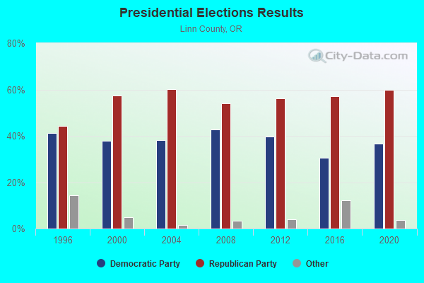
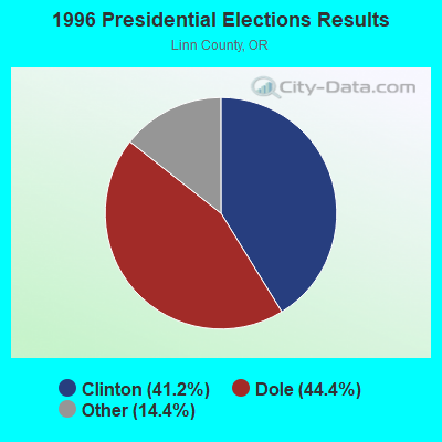

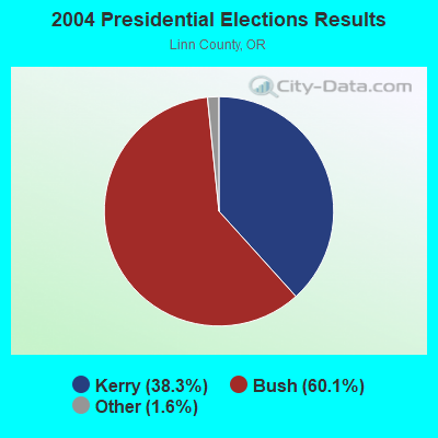
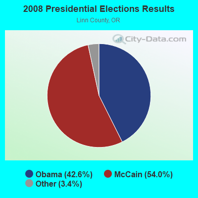
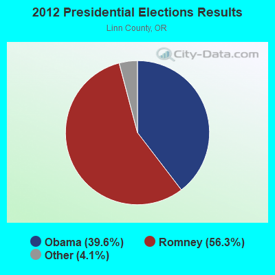
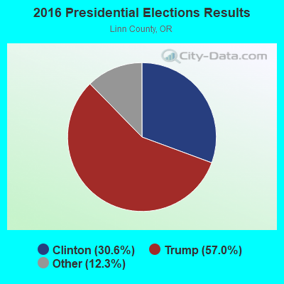
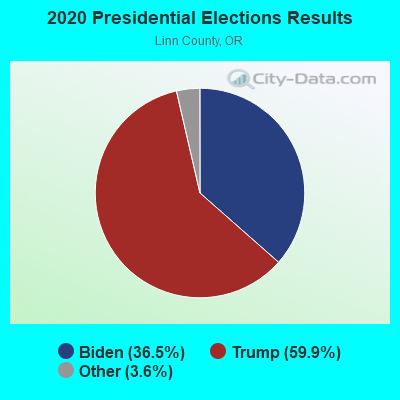
Graphs represent county-level data. Detailed 2008 Election Results
Religion statistics for Brownsville, OR (based on Linn County data)
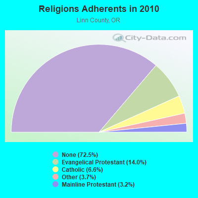

| Religion | Adherents | Congregations |
|---|---|---|
| Evangelical Protestant | 16,383 | 113 |
| Catholic | 7,690 | 8 |
| Other | 4,348 | 18 |
| Mainline Protestant | 3,697 | 17 |
| Orthodox | - | - |
| None | 84,554 | - |
Food Environment Statistics:
| Linn County: | 1.59 / 10,000 pop. |
| Oregon: | 2.03 / 10,000 pop. |
| This county: | 0.35 / 10,000 pop. |
| State: | 0.33 / 10,000 pop. |
| This county: | 3.01 / 10,000 pop. |
| State: | 2.01 / 10,000 pop. |
| Here: | 1.59 / 10,000 pop. |
| State: | 1.69 / 10,000 pop. |
| This county: | 5.40 / 10,000 pop. |
| Oregon: | 9.93 / 10,000 pop. |
| This county: | 9.3% |
| Oregon: | 7.4% |
| Linn County: | 30.0% |
| State: | 25.6% |
| Here: | 14.0% |
| Oregon: | 14.2% |
Health and Nutrition:
| Brownsville: | 51.3% |
| State: | 49.6% |
| Brownsville: | 48.2% |
| Oregon: | 46.8% |
| This city: | 28.5 |
| Oregon: | 28.5 |
| Here: | 22.1% |
| Oregon: | 21.2% |
| Brownsville: | 9.5% |
| State: | 10.1% |
| Here: | 6.9 |
| Oregon: | 6.8 |
| Brownsville: | 32.7% |
| Oregon: | 33.3% |
| Here: | 58.6% |
| Oregon: | 56.5% |
| Here: | 78.6% |
| Oregon: | 78.7% |
More about Health and Nutrition of Brownsville, OR Residents
| Local government employment and payroll (March 2022) | |||||
| Function | Full-time employees | Monthly full-time payroll | Average yearly full-time wage | Part-time employees | Monthly part-time payroll |
|---|---|---|---|---|---|
| Other Government Administration | 5 | $46,891 | $112,538 | 0 | $0 |
| Water Supply | 4 | $37,714 | $113,142 | 0 | $0 |
| Judicial and Legal | 0 | $0 | 1 | $899 | |
| Local Libraries | 0 | $0 | 2 | $3,249 | |
| Totals for Government | 9 | $84,605 | $112,807 | 3 | $4,148 |
Brownsville government finances - Expenditure in 2017 (per resident):
- Construction - Regular Highways: $40,000 ($21.72)
- Current Operations - Central Staff Services: $354,000 ($192.18)
Water Utilities: $282,000 ($153.09)
Sewerage: $245,000 ($133.01)
Financial Administration: $164,000 ($89.03)
Police Protection: $152,000 ($82.52)
Regular Highways: $130,000 ($70.58)
Libraries: $125,000 ($67.86)
Parks and Recreation: $111,000 ($60.26)
General Public Buildings: $91,000 ($49.40)
Judicial and Legal Services: $43,000 ($23.34)
Miscellaneous Commercial Activities - Other: $10,000 ($5.43)
Solid Waste Management: $8,000 ($4.34)
- General - Interest on Debt: $286,000 ($155.27)
- Intergovernmental to Local - Other - Judicial and Legal Services: $34,000 ($18.46)
- Intergovernmental to State - Judicial and Legal Services: $20,000 ($10.86)
- Other Capital Outlay - Regular Highways: $24,000 ($13.03)
- Total Salaries and Wages: $328,000 ($178.07)
- Water Utilities - Interest on Debt: $39,000 ($21.17)
Brownsville government finances - Revenue in 2017 (per resident):
- Charges - Sewerage: $508,000 ($275.79)
Parks and Recreation: $15,000 ($8.14)
Other: $11,000 ($5.97)
Miscellaneous Commercial Activities: $2,000 ($1.09)
- Local Intergovernmental - General Local Government Support: $2,000 ($1.09)
- Miscellaneous - Fines and Forfeits: $38,000 ($20.63)
Interest Earnings: $36,000 ($19.54)
General Revenue - Other: $9,000 ($4.89)
Rents: $4,000 ($2.17)
- Revenue - Water Utilities: $327,000 ($177.52)
- State Intergovernmental - Highways: $87,000 ($47.23)
General Local Government Support: $37,000 ($20.09)
- Tax - Property: $1,008,000 ($547.23)
Public Utilities Sales: $83,000 ($45.06)
Other License: $25,000 ($13.57)
Brownsville government finances - Debt in 2017 (per resident):
- Long Term Debt - Beginning Outstanding - Unspecified Public Purpose: $10,335,000 ($5610.75)
Outstanding Unspecified Public Purpose: $9,874,000 ($5360.48)
Retired Unspecified Public Purpose: $461,000 ($250.27)
Brownsville government finances - Cash and Securities in 2017 (per resident):
- Other Funds - Cash and Securities: $3,775,000 ($2049.40)
- Sinking Funds - Cash and Securities: $533,000 ($289.36)
Strongest AM radio stations in Brownsville:
- KZTU (660 AM; 10 kW; JUNCTION CITY, OR; Owner: PAMPLIN BROADCASTING-OREGON, INC.)
- KPNW (1120 AM; 50 kW; EUGENE, OR; Owner: CAPSTAR TX LIMITED PARTNERSHIP)
- KOAC (550 AM; 5 kW; CORVALLIS, OR; Owner: OREGON PUBLIC BROADCASTING)
- KUGN (590 AM; 5 kW; EUGENE, OR; Owner: CUMULUS LICENSING CORP.)
- KPOJ (620 AM; 50 kW; PORTLAND, OR; Owner: CITICASTERS LICENSES, L.P.)
- KXL (750 AM; 50 kW; PORTLAND, OR; Owner: ROSE CITY RADIO CORPORATION)
- KDUN (1030 AM; 50 kW; REEDSPORT, OR; Owner: PAMPLIN BROADCASTING-OREGON, INC.)
- KRVM (1280 AM; 5 kW; EUGENE, OR; Owner: LANE COUNTY SCHOOL DISTRICT 4J)
- KORE (1050 AM; 5 kW; SPRINGFIELD-EUGENE, OR; Owner: SUPPORT CHRISTIAN BROADCASTING)
- KFIR (720 AM; 1 kW; SWEET HOME, OR; Owner: SHAE ENTERPRISES, INC.)
- KEX (1190 AM; 50 kW; PORTLAND, OR; Owner: CITICASTERS LICENSES, L.P.)
- KPAM (860 AM; 50 kW; TROUTDALE, OR; Owner: PAMPLIN BROADCASTING-OREGON, INC.)
- KOTK (1080 AM; 50 kW; PORTLAND, OR; Owner: FISHER BROADCASTING - PORTLAND RADIO, L.L.C.)
Strongest FM radio stations in Brownsville:
- KEHK (102.3 FM; BROWNSVILLE, OR; Owner: CUMULUS LICENSING CORP.)
- K207BX (89.3 FM; EUGENE, OR; Owner: PENSACOLA CHRISTIAN COLLEGE, INC.)
- K203BT (88.5 FM; EUGENE, OR; Owner: CALVARY CHAPEL OF TWIN FALLS, INC.)
- K214CI (90.7 FM; EUGENE, OR; Owner: EDUCATIONAL MEDIA FOUNDATION)
- KXPC-FM (103.7 FM; LEBANON, OR; Owner: PORTLAND BROADCASTING, L.L.C.)
- KLVU (107.1 FM; SWEET HOME, OR; Owner: EDUCATIONAL MEDIA FOUNDATION)
- KODZ (99.1 FM; EUGENE, OR; Owner: CAPSTAR TX LIMITED PARTNERSHIP)
- KDUK-FM (104.7 FM; FLORENCE, OR; Owner: CAPSTAR TX LIMITED PARTNERSHIP)
- KFLY (101.5 FM; CORVALLIS, OR; Owner: CITICASTERS LICENSES, L.P.)
- KHPE (107.9 FM; ALBANY, OR; Owner: INTEGRITY MEDIA, INC.)
- K264AA (100.7 FM; CORVALLIS, ETC., OR; Owner: THE KBOO FOUNDATION)
- KLOO-FM (106.3 FM; CORVALLIS, OR; Owner: CITICASTERS LICENSES, L.P.)
- K276BU (103.1 FM; CORVALLIS, OR; Owner: OREGON PUBLIC BROADCASTING)
- KRKT-FM (99.9 FM; ALBANY, OR; Owner: CITICASTERS LICENSES, L.P.)
- K243AL (96.5 FM; CORVALLIS, OR; Owner: CUMULUS LICENSING CORP.)
- KKNU (93.1 FM; SPRINGFIELD-EUGENE, OR; Owner: MCKENZIE RIVER BROADCASTING COMPANY, INC.)
- KMGE (94.5 FM; EUGENE, OR; Owner: MCKENZIE RIVER BROADCASTING COMPANY, INC.)
- KUJZ (95.3 FM; CRESWELL, OR; Owner: CUMULUS LICENSING CORP.)
- KZEL-FM (96.1 FM; EUGENE, OR; Owner: CUMULUS LICENSING CORP.)
- KNRQ-FM (97.9 FM; EUGENE, OR; Owner: CUMULUS LICENSING CORP.)
TV broadcast stations around Brownsville:
- K45CV (Channel 45; CORVALLIS, OR; Owner: FISHER BROADCASTING - PORTLAND TV, L.L.C.)
- KMTR (Channel 16; EUGENE, OR; Owner: ACKERLEY MEDIA GROUP, INC.)
- K20DD (Channel 20; ALBANY, ETC., OR; Owner: MEREDITH CORPORATION)
- KLSR-TV (Channel 34; EUGENE, OR; Owner: CALIFORNIA OREGON BROADCASTING, INC.)
- KVAL-TV (Channel 13; EUGENE, OR; Owner: FISHER BROADCASTING - OREGON TV, L.L.C.)
- KEZI (Channel 9; EUGENE, OR; Owner: KEZI, INC.)
- KEPB-TV (Channel 28; EUGENE, OR; Owner: OREGON PUBLIC BROADCASTING)
- KEVU-LP (Channel 23; EUGENE, OR; Owner: CALIFORNIA OREGON BROADCASTING, INC.)
- K21FS (Channel 21; EUGENE, OR; Owner: OREGON PUBLIC BROADCASTING)
Brownsville fatal accident list:
Oct 25, 1987 02:15 PM, Northerndr, Vehicles: 1, Persons: 3, Fatalities: 1
Sep 8, 1985 00:55 AM, A481, Vehicles: 2, Persons: 3, Fatalities: 1, Drunk persons involved: 1
- National Bridge Inventory (NBI) Statistics
- 14Number of bridges
- 108ft / 33.3mTotal length
- $3,560,000Total costs
- 11,038Total average daily traffic
- 1,257Total average daily truck traffic
- 15,331Total future (year 2041) average daily traffic

- New bridges - historical statistics
- 11940-1949
- 51960-1969
- 51970-1979
- 11990-1999
- 22000-2009
FCC Registered Cell Phone Towers:
1 (See the full list of FCC Registered Cell Phone Towers in Brownsville)FCC Registered Antenna Towers:
33 (See the full list of FCC Registered Antenna Towers)FCC Registered Broadcast Land Mobile Towers:
2- Scott Mt 5.8 Miles E (Lat: 44.397056 Lon: -122.867861), Call Sign: KRC829, Licensee ID: L00017693,
Assigned Frequencies: 47.0400 MHz, 47.0600 MHz, 47.1600 MHz, 47.1800 MHz, Grant Date: 12/15/1999, Expiration Date: 02/01/2005, Cancellation Date: 04/03/2003, Registrant: State Of Oregon, 455 Airport Rd Bldg C, Salem, OR 97301-5375, Phone: (503) 378-3650
- Scott Mt 5.8 Mi E (Lat: 44.397056 Lon: -122.867861), Call Sign: WGI390, Licensee ID: L00017693,
Assigned Frequencies: 453.950 MHz, Grant Date: 12/15/1999, Expiration Date: 02/01/2005, Cancellation Date: 04/03/2003, Registrant: State Of Oregon, 455 Airport Rd Bldg C, Salem, OR 97301-5375, Phone: (503) 378-2650
FCC Registered Microwave Towers:
39 (See the full list of FCC Registered Microwave Towers in this town)FCC Registered Amateur Radio Licenses:
37 (See the full list of FCC Registered Amateur Radio Licenses in Brownsville)FAA Registered Aircraft:
6- Aircraft: PIPER J3C-65 (Category: Land, Seats: 2, Weight: Up to 12,499 Pounds, Speed: 67 mph), Engine: CONT MOTOR A&C65 SERIES (65 HP) (Reciprocating)
N-Number: 33557, N33557, N-33557, Serial Number: 14034, Year manufactured: 1946, Airworthiness Date: 05/11/1960, Certificate Issue Date: 11/09/2016
Registrant (Individual): Jana T Robertson, Po Box 519, Brownsville, OR 97327 - Aircraft: BOEING B75N1 (Category: Land, Seats: 2, Weight: Up to 12,499 Pounds, Speed: 93 mph), Engine: LYCOMING R680 (215 HP) (Reciprocating)
N-Number: 5132N, N5132N, N-5132N, Serial Number: 75-7503, Year manufactured: 1943, Airworthiness Date: 09/11/1995, Certificate Issue Date: 03/31/1984
Registrant (Individual): Ronald F Coulter, Po Box 727, Brownsville, OR 97327 - Aircraft: BEECH B35 (Category: Land, Seats: 4, Weight: Up to 12,499 Pounds, Speed: 120 mph), Engine: CONT MOTOR E225 SERIES (225 HP) (Reciprocating)
N-Number: 5202C, N5202C, N-5202C, Serial Number: D-2547, Year manufactured: 1950, Airworthiness Date: 12/20/1955, Certificate Issue Date: 07/15/2014
Registrant (Individual): Joe T James, Po Box 123, Brownsville, OR 97327 - Aircraft: CESSNA 172L (Category: Land, Seats: 4, Weight: Up to 12,499 Pounds, Speed: 105 mph), Engine: LYCOMING 0-320 SERIES (180 HP) (Reciprocating)
N-Number: 7251Q, N7251Q, N-7251Q, Serial Number: 17260551, Year manufactured: 1972, Airworthiness Date: 03/29/1972, Certificate Issue Date: 03/23/2016
Registrant (Individual): Crystal M Garcia, Po Box 311, Brownsville, OR 97327 - Aircraft: AERONCA 7EC (Category: Land, Seats: 2, Weight: Up to 12,499 Pounds, Speed: 90 mph), Engine: CONT MOTOR C90 SERIES (95 HP) (Reciprocating)
N-Number: 9081B, N9081B, N-9081B, Serial Number: 7EC-645, Year manufactured: 1958, Airworthiness Date: 03/20/1958, Certificate Issue Date: 04/01/1985
Registrant (Individual): Ronald F Coulter, Po Box 727, Brownsville, OR 97327 - Aircraft: STINSON 108-2 (Category: Land, Seats: 4, Weight: Up to 12,499 Pounds, Speed: 90 mph), Engine: FRANKLIN 6A4165 SERIES (165 HP) (Reciprocating)
N-Number: 959D, N959D, N-959D, Serial Number: 108-2959, Year manufactured: 1949, Airworthiness Date: 01/03/1973, Certificate Issue Date: 08/25/2020
Registrant (Individual): Arlen D Krabill, 1121 Pine St, Brownsville, OR 97327
2002 - 2018 National Fire Incident Reporting System (NFIRS) incidents
- Fire incident types reported to NFIRS in Brownsville, OR
- 5653.8%Structure Fires
- 3028.8%Outside Fires
- 1615.4%Mobile Property/Vehicle Fires
- 21.9%Other
 Based on the data from the years 2002 - 2018 the average number of fires per year is 6. The highest number of reported fire incidents - 14 took place in 2003, and the least - 1 in 2017. The data has a decreasing trend.
 When looking into fire subcategories, the most reports belonged to: Structure Fires (53.8%), and Outside Fires (28.8%).
| Most common first names in Brownsville, OR among deceased individuals | ||
| Name | Count | Lived (average) |
|---|---|---|
| Robert | 17 | 74.4 years |
| John | 16 | 75.1 years |
| Mary | 13 | 78.3 years |
| Charles | 13 | 79.5 years |
| William | 11 | 75.4 years |
| James | 10 | 69.4 years |
| Donald | 9 | 74.0 years |
| Ruth | 9 | 81.2 years |
| George | 8 | 75.2 years |
| Dorothy | 8 | 76.1 years |
| Most common last names in Brownsville, OR among deceased individuals | ||
| Last name | Count | Lived (average) |
|---|---|---|
| Smith | 11 | 77.3 years |
| Miller | 10 | 74.1 years |
| Nelson | 6 | 89.8 years |
| Evans | 5 | 79.2 years |
| Howell | 5 | 73.7 years |
| Johnson | 5 | 87.0 years |
| Jones | 5 | 80.6 years |
| Fullager | 4 | 79.2 years |
| Anthony | 4 | 71.0 years |
| Lawler | 4 | 70.0 years |

- 46.9%Electricity
- 43.2%Utility gas
- 5.6%Wood
- 2.2%Other fuel
- 2.1%Bottled, tank, or LP gas

- 66.2%Utility gas
- 27.2%Electricity
- 4.6%No fuel used
- 2.0%Wood
Brownsville compared to Oregon state average:
- Unemployed percentage below state average.
- Black race population percentage significantly below state average.
- Hispanic race population percentage significantly below state average.
- Foreign-born population percentage significantly below state average.

|
Total of 3 patent applications in 2008-2024.