Bridge Statistics for Versailles, Kentucky (KY)
Condition, Traffic, Stress, Structural Evaluation, Project Costs
- National Bridge Inventory (NBI) Statistics
- 18Number of bridges
- 131ft / 39.8mTotal length
- $948,000Total costs
- 143,372Total average daily traffic
- 22,121Total average daily truck traffic
- National Bridge Inventory (NBI) Registered Bridges for Versailles
- No street view available for this location
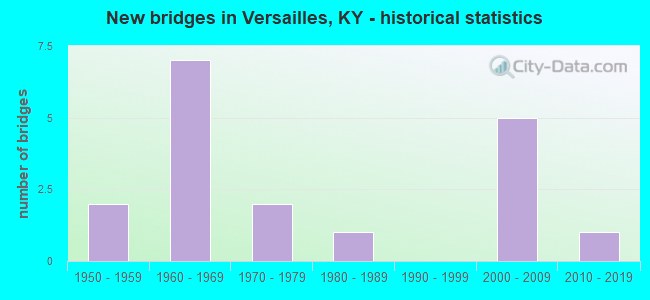
- New bridges - historical statistics
- 21950-1959
- 71960-1969
- 21970-1979
- 11980-1989
- 52000-2009
- 12010-2019


- Bridge Condition - Deck
- 9.1%Very good
- 45.5%Good
- 27.3%Satisfactory
- 18.2%Fair

- Bridge Condition - Superstructure
- 18.2%Very good
- 27.3%Good
- 36.4%Satisfactory
- 9.1%Fair
- 9.1%Poor

- Bridge Condition - Substructure
- 45.5%Good
- 18.2%Satisfactory
- 36.4%Fair

- Bridge Condition - Channel
- 11.1%Very good
- 11.1%Good
- 22.2%Satisfactory
- 55.6%Fair

- Bridge Condition - Culverts
- 50.0%Satisfactory
- 50.0%Fair
Find on map >> Show street view
Structure Number: 120B00009N, Location: 1.4 MI S. OF JCT KY 2331 (Lat: 38.096667, Lng: -84.800278), Route carried "on" structure: State highway 1659, Year Built: 1952, Status: Posted for load, Structure Length: 1.46m (4.79ft), Average Daily Traffic: 343 (year 2020), Average Future Daily Traffic: 298 (year 2040), Design Load: H 15, Features Intersected: GLENS CREEK
Minimum Vertical Clearance: 30+ m (98+ ft), Kilometerpoint: 8.060, Lanes on structure: 2, Owner: State Highway Agency, Approaching Roadway Width: 6.4m (21.0ft), Material/Design: Concrete, Design/Construction: Tee Beam, Number Of Spans In Main Unit: 1, Length of Maximum Span: 13.7m (44.9ft), Curb or Sidewalk Widths: Left: 0.3m (1.0ft), Right: 0.3m (1.0ft), Curb-To-Curb Width: 6.8m (22.3ft), Out-to-Out Width: 8.0m (26.2ft)
Condition: Deck: Good, Superstructure: Good, Substructure: Good, Channel: Satisfactory, Operating Rating: 34.0 metric tons, Method Used To Determine Operating Rating: Load Factor (LF), Inventory Rating: 20.4 metric tons, Method Used To Determine Inventory Rating: Load Factor (LF), Structural Evaluation: Somewhat better than minimum adequacy, Deck Geometry: Meets minimum limits, Waterway Adequacy: Equal to present desirable criteria, Approach Roadway Alignment: Better than present minimum criteria, Bridge Posting: Required (Relationship of Operating Rating to Maximum Legal Load: > 39.9% below), Designated Inspection Frequency: Every 24 months, Inspection Date: November 2020, Deck Structure Type: Concrete Cast-file-Place, Wearing Surface/Protective System: Wearing Surface: Bituminous
Find on map >> Show street view
Structure Number: 120B00014N, Location: 3.0 MI NORTH OF JCT US 60 (Lat: 38.083611, Lng: -84.773333), Route carried "on" structure: State highway 1659, Year Built: 1970, Status: Posted for load, Structure Length: 0.98m (3.22ft), Average Daily Traffic: 343 (year 2020), Average Future Daily Traffic: 301 (year 2040), Design Load: H 20, Features Intersected: CAMDEN CREEK
Minimum Vertical Clearance: 30+ m (98+ ft), Kilometerpoint: 4.921, Lanes on structure: 2, Owner: State Highway Agency, Approaching Roadway Width: 5.5m (18.0ft), Material/Design: Prestressed concrete, Design/Construction: Box Beam or Girders - Multiple, Number Of Spans In Main Unit: 1, Length of Maximum Span: 8.7m (28.5ft), Curb-To-Curb Width: 6.0m (19.7ft), Out-to-Out Width: 6.5m (21.3ft)
Condition: Deck: Satisfactory, Superstructure: Poor, Substructure: Fair, Channel: Good, Operating Rating: 38.4 metric tons, Method Used To Determine Operating Rating: Load Factor (LF), Inventory Rating: 23.0 metric tons, Method Used To Determine Inventory Rating: Load Factor (LF), Structural Evaluation: Meets minimum limits, Deck Geometry: High priority of corrective action, Waterway Adequacy: Better than present minimum criteria, Approach Roadway Alignment: Somewhat better than minimum adequacy, Bridge Posting: Required (Relationship of Operating Rating to Maximum Legal Load: > 39.9% below), Length Of Structure Improvement: 0.10m (0.33ft), Designated Inspection Frequency: Every 24 months, Inspection Date: November 2020, Bridge Improvement Cost: $84,000, Total Project Cost: $84,000, Deck Structure Type: Concrete Precast Panels, Wearing Surface/Protective System: Wearing Surface: Monolithic Concrete
Find on map >> Show street view
Structure Number: 120B00019N, Location: 3.5 MI S OF JCT US 62 (Lat: 38.009444, Lng: -84.765556), Route carried "on" structure: State highway 1964, Year Built: 1965, Status: Posted for load, Structure Length: 6.31m (20.70ft), Average Daily Traffic: 1,315 (year 2018), Average Future Daily Traffic: 1,157 (year 2038), Design Load: H 20, Features Intersected: BLUEGRASS PARKWAY
Minimum Vertical Clearance: 30+ m (98+ ft), Kilometerpoint: 9.881, Lanes on structure: 2, Lanes under structure: 4, Owner: State Highway Agency, Approaching Roadway Width: 7.6m (24.9ft), Skew: 2 degrees, Material/Design: Concrete continuous, Design/Construction: Tee Beam, Number Of Spans In Main Unit: 4, Length of Maximum Span: 17.3m (56.8ft), Curb or Sidewalk Widths: Left: 0.5m (1.6ft), Right: 0.5m (1.6ft), Curb-To-Curb Width: 8.6m (28.2ft), Out-to-Out Width: 10.1m (33.1ft)
Condition: Deck: Fair, Superstructure: Satisfactory, Substructure: Fair, Operating Rating: 36.9 metric tons, Method Used To Determine Operating Rating: Load Factor (LF), Inventory Rating: 22.1 metric tons, Method Used To Determine Inventory Rating: Load Factor (LF), Structural Evaluation: Somewhat better than minimum adequacy, Deck Geometry: Somewhat better than minimum adequacy, Underclear: Meets minimum limits, Approach Roadway Alignment: Better than present minimum criteria, Bridge Posting: Required (Relationship of Operating Rating to Maximum Legal Load: 20.0 - 29.9% below), Designated Inspection Frequency: Every 24 months, Inspection Date: November 2020, Deck Structure Type: Concrete Cast-file-Place, Wearing Surface/Protective System: Wearing Surface: Latex Concrete
Find on map >> Show street view
Structure Number: 120B00027N, Location: 2 MI E OF JCT KY 33 (Lat: 38.031111, Lng: -84.699722), Route carried "on" structure: County highway 1100, Year Built: 1965, Status: Open, Structure Length: 6.22m (20.41ft), Average Daily Traffic: 1,758 (year 2018), Average Future Daily Traffic: 1,634 (year 2038), Design Load: H 20, Features Intersected: BLUEGRASS PARKWAY, Facility Carried by Structure: HUNTERTOWN RD
Minimum Vertical Clearance: 30+ m (98+ ft), Kilometerpoint: 2.509, Lanes on structure: 2, Lanes under structure: 4, Owner: State Highway Agency, Approaching Roadway Width: 7.3m (24.0ft), Skew: 1 degrees, Material/Design: Concrete continuous, Design/Construction: Tee Beam, Number Of Spans In Main Unit: 4, Length of Maximum Span: 18.3m (60.0ft), Curb or Sidewalk Widths: Left: 0.5m (1.6ft), Right: 0.5m (1.6ft), Curb-To-Curb Width: 8.5m (27.9ft), Out-to-Out Width: 10.1m (33.1ft)
Condition: Deck: Satisfactory, Superstructure: Satisfactory, Substructure: Satisfactory, Operating Rating: 49.1 metric tons, Method Used To Determine Operating Rating: Load Factor (LF), Inventory Rating: 29.4 metric tons, Method Used To Determine Inventory Rating: Load Factor (LF), Structural Evaluation: Equal to present minimum criteria, Deck Geometry: Somewhat better than minimum adequacy, Underclear: Equal to present minimum criteria, Approach Roadway Alignment: Better than present minimum criteria, Designated Inspection Frequency: Every 24 months, Inspection Date: November 2020, Deck Structure Type: Concrete Cast-file-Place, Wearing Surface/Protective System: Wearing Surface: Monolithic Concrete
Find on map >> Show street view
Structure Number: 120B00029N, Location: .30 MI WEST OF KY 1964 OP (Lat: 38.007500, Lng: -84.770556), Route carried "on" structure: State highway 9002, Year Built: 1965, Status: Open, Structure Length: 0.88m (2.89ft), Average Daily Traffic: 13,483 (year 2020), Truck Traffic: 26%, Average Future Daily Traffic: 12,674 (year 2040), Design Load: H 20, Features Intersected: BR OF GRIER CREEK
Minimum Vertical Clearance: 30+ m (98+ ft), Kilometerpoint: 105.240, Lanes on structure: 4, Base Highway Network: Yes, Owner: State Highway Agency, Approaching Roadway Width: 10.3m (33.8ft), Skew: 24 degrees, Material/Design: Concrete, Design/Construction: Culvert, Number Of Spans In Main Unit: 2, Length of Maximum Span: 4.3m (14.1ft)
Condition: Channel: Fair, Culverts: Fair, Operating Rating: 99.8 metric tons, Method Used To Determine Operating Rating: Load Factor (LF), Inventory Rating: 78.0 metric tons, Method Used To Determine Inventory Rating: Load Factor (LF), Structural Evaluation: Somewhat better than minimum adequacy, Waterway Adequacy: Better than present minimum criteria, Approach Roadway Alignment: Equal to present desirable criteria, Designated Inspection Frequency: Every 24 months, Inspection Date: November 2020
Find on map >> Show street view
Structure Number: 120B00030N, Location: WB ENT RMP TO BG PKWY (Lat: 38.046944, Lng: -84.680556), Route carried "on" structure: State highway 9002, Year Built: 1965, Status: Open, Structure Length: 7.01m (23.00ft), Average Daily Traffic: 21,663 (year 2020), Truck Traffic: 14%, Average Future Daily Traffic: 20,363 (year 2040), Design Load: HS 20, Features Intersected: US 60
Minimum Vertical Clearance: 5.58m (18.31ft), Kilometerpoint: 114.476, Lanes on structure: 1, Lanes under structure: 4, Base Highway Network: Yes, Owner: State Highway Agency, Approaching Roadway Width: 7.6m (24.9ft), Skew: 4 degrees, Material/Design: Steel, Design/Construction: Stringer/Multi-beam, Number Of Spans In Main Unit: 3, Length of Maximum Span: 33.5m (109.9ft), Curb or Sidewalk Widths: Left: 0.5m (1.6ft), Right: 0.5m (1.6ft), Curb-To-Curb Width: 7.3m (24.0ft), Out-to-Out Width: 8.2m (26.9ft)
Condition: Deck: Satisfactory, Superstructure: Satisfactory, Substructure: Fair, Operating Rating: 91.9 metric tons, Method Used To Determine Operating Rating: Load Factor (LF), Inventory Rating: 55.2 metric tons, Method Used To Determine Inventory Rating: Load Factor (LF), Structural Evaluation: Somewhat better than minimum adequacy, Deck Geometry: High priority of replacement, Underclear: Equal to present minimum criteria, Approach Roadway Alignment: Somewhat better than minimum adequacy, Length Of Structure Improvement: 0.72m (2.36ft), Designated Inspection Frequency: Every 24 months, Inspection Date: November 2020, Bridge Improvement Cost: $864,000, Total Project Cost: $864,000, Deck Structure Type: Concrete Cast-file-Place, Wearing Surface/Protective System: Wearing Surface: Latex Concrete
Find on map >> Show street view
Structure Number: 120B00035N, Location: 100' S OF JCT KY 1659 (Lat: 38.096667, Lng: -84.793611), Route carried "on" structure: State highway 1685, Year Built: 1956, Status: Posted for load, Structure Length: 1.83m (6.00ft), Average Daily Traffic: 357 (year 2018), Average Future Daily Traffic: 314 (year 2038), Design Load: H 15, Features Intersected: GLENS CREEK
Minimum Vertical Clearance: 30+ m (98+ ft), Kilometerpoint: 7.891, Lanes on structure: 2, Owner: State Highway Agency, Approaching Roadway Width: 5.5m (18.0ft), Material/Design: Steel, Design/Construction: Stringer/Multi-beam, Number Of Spans In Main Unit: 2, Length of Maximum Span: 8.7m (28.5ft), Curb or Sidewalk Widths: Left: 0.2m (0.7ft), Right: 0.2m (0.7ft), Curb-To-Curb Width: 7.4m (24.3ft), Out-to-Out Width: 8.4m (27.6ft)
Condition: Deck: Fair, Superstructure: Fair, Substructure: Fair, Channel: Satisfactory, Operating Rating: 31.1 metric tons, Method Used To Determine Operating Rating: Load Factor (LF), Inventory Rating: 18.7 metric tons, Method Used To Determine Inventory Rating: Load Factor (LF), Structural Evaluation: Somewhat better than minimum adequacy, Deck Geometry: Somewhat better than minimum adequacy, Waterway Adequacy: Better than present minimum criteria, Approach Roadway Alignment: Equal to present minimum criteria, Bridge Posting: Required (Relationship of Operating Rating to Maximum Legal Load: > 39.9% below), Designated Inspection Frequency: Every 12 months, Inspection Date: November 2021, Deck Structure Type: Concrete Cast-file-Place, Wearing Surface/Protective System: Wearing Surface: Bituminous
Find on map >> Show street view
Structure Number: 120B00040N, Location: 1.2 MI N OF JCT KY 169 (Lat: 38.025000, Lng: -84.723611), Route carried "on" structure: State highway 33, Year Built: 2008, Status: Open, Structure Length: 7.99m (26.21ft), Average Daily Traffic: 10,977 (year 2019), Truck Traffic: 9%, Average Future Daily Traffic: 10,208 (year 2039), Design Load: HS 25 or greater, Features Intersected: BLUE GRASS PARKWAY
Minimum Vertical Clearance: 30+ m (98+ ft), Kilometerpoint: 19.113, Lanes on structure: 2, Lanes under structure: 4, Owner: State Highway Agency, Approaching Roadway Width: 21.6m (70.9ft), Material/Design: Prestressed concrete continuous, Design/Construction: Stringer/Multi-beam, Number Of Spans In Main Unit: 4, Length of Maximum Span: 23.3m (76.4ft), Curb-To-Curb Width: 21.9m (71.9ft), Out-to-Out Width: 22.9m (75.1ft)
Condition: Deck: Good, Superstructure: Very good, Substructure: Good, Operating Rating: 69.1 metric tons, Method Used To Determine Operating Rating: Load Factor (LF), Inventory Rating: 41.5 metric tons, Method Used To Determine Inventory Rating: Load Factor (LF), Structural Evaluation: Better than present minimum criteria, Deck Geometry: Superior to present desirable criteria, Underclear: Superior to present desirable criteria, Approach Roadway Alignment: Better than present minimum criteria, Designated Inspection Frequency: Every 24 months, Inspection Date: November 2020, Deck Structure Type: Concrete Cast-file-Place, Wearing Surface/Protective System: Wearing Surface: Monolithic Concrete, Deck Protection: Epoxy Coated Reinforcing
Find on map >> Show street view
Structure Number: 120C00014N, Location: .5 MI W OF JCT KY 1964 (Lat: 38.008056, Lng: -84.773611), Route carried "on" structure: County highway 1215, Year Built: 1974, Status: Open, Structure Length: 1.51m (4.95ft), Average Daily Traffic: 405 (year 2011), Average Future Daily Traffic: 352 (year 2031), Features Intersected: BR OF GRIER CREEK, Facility Carried by Structure: SCOTTS FERRY RD
Minimum Vertical Clearance: 30+ m (98+ ft), Kilometerpoint: 0.758, Lanes on structure: 2, Owner: County Highway Agency, Approaching Roadway Width: 5.1m (16.7ft), Skew: 6 degrees, Material/Design: Concrete, Design/Construction: Culvert, Number Of Spans In Main Unit: 2, Length of Maximum Span: 7.6m (24.9ft), Curb-To-Curb Width: 6.9m (22.6ft), Out-to-Out Width: 6.9m (22.6ft)
Condition: Channel: Fair, Culverts: Satisfactory, Operating Rating: 54.4 metric tons, Method Used To Determine Operating Rating: Field evaluation and documented engineering judgment, Inventory Rating: 39.9 metric tons, Method Used To Determine Inventory Rating: Field evaluation and documented engineering judgment, Structural Evaluation: Equal to present minimum criteria, Deck Geometry: Meets minimum limits, Waterway Adequacy: Better than present minimum criteria, Approach Roadway Alignment: Equal to present minimum criteria, Designated Inspection Frequency: Every 24 months, Inspection Date: December 2020, Deck Structure Type: Concrete Cast-file-Place, Wearing Surface/Protective System: Wearing Surface: Bituminous
Find on map >> Show street view
Structure Number: 120C00031N, Location: 1.7 MI S JCT US 62 (Lat: 38.018889, Lng: -84.814444), Route carried "on" structure: County highway 1219, Year Built: 2001, Status: Open, Structure Length: 1.22m (4.00ft), Average Daily Traffic: 207 (year 2011), Average Future Daily Traffic: 180 (year 2031), Design Load: HS 25 or greater, Features Intersected: BRANCH-GRIER CREEK, Facility Carried by Structure: SHRYOCKS FERRY RD
Minimum Vertical Clearance: 30+ m (98+ ft), Kilometerpoint: 2.968, Lanes on structure: 2, Owner: County Highway Agency, Approaching Roadway Width: 6.1m (20.0ft), Material/Design: Prestressed concrete, Design/Construction: Box Beam or Girders - Multiple, Number Of Spans In Main Unit: 1, Length of Maximum Span: 11.2m (36.7ft), Curb-To-Curb Width: 7.0m (23.0ft), Out-to-Out Width: 7.3m (24.0ft)
Condition: Deck: Good, Superstructure: Good, Substructure: Good, Channel: Fair, Operating Rating: 73.0 metric tons, Method Used To Determine Operating Rating: Load Factor (LF), Inventory Rating: 43.8 metric tons, Method Used To Determine Inventory Rating: Load Factor (LF), Structural Evaluation: Better than present minimum criteria, Deck Geometry: Meets minimum limits, Waterway Adequacy: Better than present minimum criteria, Approach Roadway Alignment: Equal to present minimum criteria, Designated Inspection Frequency: Every 24 months, Inspection Date: December 2020, Deck Structure Type: Concrete Precast Panels, Wearing Surface/Protective System: Wearing Surface: Monolithic Concrete, Membrane: Preformed Fabric
Find on map >> Show street view
Structure Number: 120C00035N, Location: 1.8 MI S JCT US 62 (Lat: 38.018611, Lng: -84.816944), Route carried "on" structure: County highway 1219, Year Built: 2003, Status: Open, Structure Length: 1.68m (5.51ft), Average Daily Traffic: 207 (year 2011), Average Future Daily Traffic: 180 (year 2031), Design Load: HS 25 or greater, Features Intersected: GRIERS CREEK, Facility Carried by Structure: SHRYOCKS FERRY RD
Minimum Vertical Clearance: 30+ m (98+ ft), Kilometerpoint: 3.196, Lanes on structure: 2, Owner: County Highway Agency, Approaching Roadway Width: 7.0m (23.0ft), Skew: 3 degrees, Material/Design: Prestressed concrete, Design/Construction: Box Beam or Girders - Multiple, Number Of Spans In Main Unit: 1, Length of Maximum Span: 15.6m (51.2ft), Curb-To-Curb Width: 7.0m (23.0ft), Out-to-Out Width: 7.3m (24.0ft)
Condition: Deck: Good, Superstructure: Satisfactory, Substructure: Satisfactory, Channel: Fair, Operating Rating: 77.8 metric tons, Method Used To Determine Operating Rating: Load Factor (LF), Inventory Rating: 46.7 metric tons, Method Used To Determine Inventory Rating: Load Factor (LF), Structural Evaluation: Equal to present minimum criteria, Deck Geometry: Meets minimum limits, Waterway Adequacy: Equal to present minimum criteria, Approach Roadway Alignment: Somewhat better than minimum adequacy, Designated Inspection Frequency: Every 24 months, Inspection Date: December 2020, Deck Structure Type: Concrete Precast Panels, Wearing Surface/Protective System: Wearing Surface: Monolithic Concrete, Membrane: Preformed Fabric
Find on map >> Show street view
Structure Number: 120C00036N, Location: 150 FT EAST OF JCT KY 33 (Lat: 37.972222, Lng: -84.720833), Route carried "on" structure: County highway 1119, Year Built: 2009, Status: Open, Structure Length: 1.16m (3.81ft), Average Daily Traffic: 554 (year 2012), Average Future Daily Traffic: 481 (year 2032), Design Load: HS 25 or greater, Features Intersected: CLEAR CREEK, Facility Carried by Structure: DELANEY FERRY ROAD
Minimum Vertical Clearance: 30+ m (98+ ft), Kilometerpoint: 3.038, Lanes on structure: 2, Owner: County Highway Agency, Approaching Roadway Width: 5.3m (17.4ft), Material/Design: Prestressed concrete, Design/Construction: Box Beam or Girders - Multiple, Number Of Spans In Main Unit: 1, Length of Maximum Span: 10.7m (35.1ft), Curb-To-Curb Width: 8.1m (26.6ft), Out-to-Out Width: 8.6m (28.2ft)
Condition: Deck: Good, Superstructure: Very good, Substructure: Good, Channel: Very good, Operating Rating: 69.9 metric tons, Method Used To Determine Operating Rating: Load Factor (LF), Inventory Rating: 41.9 metric tons, Method Used To Determine Inventory Rating: Load Factor (LF), Structural Evaluation: Better than present minimum criteria, Deck Geometry: Somewhat better than minimum adequacy, Waterway Adequacy: Equal to present desirable criteria, Approach Roadway Alignment: Better than present minimum criteria, Designated Inspection Frequency: Every 24 months, Inspection Date: December 2020, Deck Structure Type: Concrete Precast Panels, Wearing Surface/Protective System: Wearing Surface: Bituminous, Membrane: Preformed Fabric
Find on map >> Show street view
Structure Number: 120C00040N, Location: 1.8MI W OF SCOTTS FERRY (Lat: 38.014047, Lng: -84.798428), Route carried "on" structure: County highway 1217, Year Built: 2017, Status: Open, Structure Length: 1.58m (5.18ft), Average Daily Traffic: 88 (year 2011), Average Future Daily Traffic: 76 (year 2031), Design Load: HS 25 or greater, Features Intersected: GRIER CREEK, Facility Carried by Structure: GRIERS CREEK RD
Minimum Vertical Clearance: 30+ m (98+ ft), Kilometerpoint: 1.880, Lanes on structure: 1, Owner: County Highway Agency, Approaching Roadway Width: 4.3m (14.1ft), Skew: 3 degrees, Material/Design: Prestressed concrete, Design/Construction: Box Beam or Girders - Multiple, Number Of Spans In Main Unit: 1, Length of Maximum Span: 14.7m (48.2ft), Curb-To-Curb Width: 4.5m (14.8ft), Out-to-Out Width: 5.1m (16.7ft)
Condition: Deck: Very good, Superstructure: Good, Substructure: Good, Channel: Fair, Operating Rating: 75.8 metric tons, Method Used To Determine Operating Rating: Load Factor (LF), Inventory Rating: 45.4 metric tons, Method Used To Determine Inventory Rating: Load Factor (LF), Structural Evaluation: Better than present minimum criteria, Deck Geometry: Equal to present minimum criteria, Waterway Adequacy: Better than present minimum criteria, Approach Roadway Alignment: Equal to present minimum criteria, Designated Inspection Frequency: Every 24 months, Inspection Date: December 2020, Deck Structure Type: Concrete Precast Panels, Wearing Surface/Protective System: Wearing Surface: Monolithic Concrete, Membrane: Preformed Fabric
Find on map >> Show street view
Structure Number: 120B00019N, Location: 3.5 MI S OF JCT US 62 (Lat: 38.009444, Lng: -84.765556), Route carried "under" structure: State highway 9002, Year Built: 1965, Structure Length: 0. m, Average Daily Traffic: 13,483 (year 2020), Truck Traffic: 26%, Features Intersected: BLUEGRASS PARKWAY, Facility Carried by Structure: KY-1964
Minimum Vertical Clearance: 6.12m (20.08ft), Kilometerpoint: 105.707, Lanes on structure: 2, Lanes under structure: 4, Material/Design: Concrete continuous, Design/Construction: Tee Beam, Length of Maximum Span: 17.3m (56.8ft)
Find on map >> Show street view
Structure Number: 120B00027N, Location: 2 MI E OF JCT KY 33 (Lat: 38.031111, Lng: -84.699722), Route carried "under" structure: State highway 9002, Year Built: 1965, Structure Length: 0. m, Average Daily Traffic: 21,663 (year 2020), Truck Traffic: 14%, Features Intersected: BLUEGRASS PARKWAY, Facility Carried by Structure: HUNTERTOWN RD
Minimum Vertical Clearance: 5.49m (18.01ft), Kilometerpoint: 112.009, Lanes on structure: 2, Lanes under structure: 4, Material/Design: Concrete continuous, Design/Construction: Tee Beam, Length of Maximum Span: 18.3m (60.0ft)
Find on map >> Show street view
Structure Number: 120B00030N, Location: WB ENT RMP TO BG PKWY (Lat: 38.046944, Lng: -84.680556), Route carried "under" structure: US 60, Year Built: 1965, Structure Length: 0. m, Average Daily Traffic: 25,121 (year 2019), Truck Traffic: 11%, Features Intersected: US 60, Facility Carried by Structure: BG PKWY - 9002
Minimum Vertical Clearance: 5.13m (16.83ft), Kilometerpoint: 18.099, Lanes on structure: 1, Lanes under structure: 4, Material/Design: Steel, Design/Construction: Stringer/Multi-beam, Length of Maximum Span: 33.5m (109.9ft)
Find on map >> Show street view
Structure Number: 120B00040N, Location: 1.2 MI N OF JCT KY 169 (Lat: 38.025000, Lng: -84.723611), Route carried "under" structure: State highway 9002, Year Built: 2008, Structure Length: 0. m, Average Daily Traffic: 13,483 (year 2020), Truck Traffic: 26%, Features Intersected: BLUE GRASS PARKWAY, Facility Carried by Structure: KY 33
Minimum Vertical Clearance: 5.89m (19.32ft), Kilometerpoint: 109.823, Lanes on structure: 2, Lanes under structure: 4, Material/Design: Prestressed concrete continuous, Design/Construction: Stringer/Multi-beam, Length of Maximum Span: 23.3m (76.4ft)
Find on map >> Show street view
Structure Number: 120X00001N, Location: 50' W Merewood Drive (Lat: 38.063611, Lng: -84.731111), Route carried "under" structure: US 60, Year Built: 1986, Structure Length: 0. m, Average Daily Traffic: 17,922 (year 2020), Truck Traffic: 10%, Features Intersected: US 60, Facility Carried by Structure: PED. OVER PASS
Minimum Vertical Clearance: 5.44m (17.85ft), Kilometerpoint: 13.069, Lanes under structure: 4, Material/Design: Prestressed concrete, Design/Construction: Stringer/Multi-beam, Length of Maximum Span: 29.3m (96.1ft)