Bridge Statistics for Suffern, New York (NY)
Condition, Traffic, Stress, Structural Evaluation, Project Costs
- National Bridge Inventory (NBI) Statistics
- 20Number of bridges
- 509ft / 155mTotal length
- $178,060,000Total costs
- 538,507Total average daily traffic
- 67,065Total average daily truck traffic
- National Bridge Inventory (NBI) Registered Bridges for Suffern
- No street view available for this location
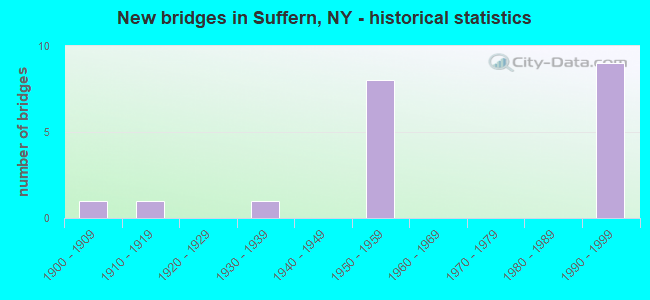
- New bridges - historical statistics
- 11900-1909
- 11910-1919
- 11930-1939
- 81950-1959
- 91990-1999

- Reconstructed bridges - Historical Statistics
- 21970-1979
- 01980-1989
- 11990-1999


- Bridge Condition - Deck
- 11.1%Very good
- 33.3%Good
- 33.3%Satisfactory
- 11.1%Fair
- 11.1%Poor

- Bridge Condition - Superstructure
- 11.1%Very good
- 22.2%Good
- 22.2%Satisfactory
- 33.3%Fair
- 11.1%Poor

- Bridge Condition - Substructure
- 11.1%Very good
- 22.2%Good
- 11.1%Satisfactory
- 55.6%Fair

- Bridge Condition - Channel
- 25.0%Very good
- 25.0%Good
- 25.0%Satisfactory
- 25.0%Poor
Find on map >> Show street view
Structure Number: 102762, Location: 2.1 MI E JCT RTS 59+17 (Lat: 41.115192, Lng: -74.145750), Route carried "on" structure: State highway 59, Year Built: 1933, Status: Open, Structure Length: 2.04m (6.69ft), Average Daily Traffic: 11,746 (year 2016), Truck Traffic: 4%, Average Future Daily Traffic: 11,801 (year 2040), Features Intersected: MAHWAH RIVER
Minimum Vertical Clearance: 30+ m (98+ ft), Kilometerpoint: 3.186, Lanes on structure: 2, Base Highway Network: Yes, Owner: State Highway Agency, Approaching Roadway Width: 13.4m (44.0ft), Material/Design: Steel, Design/Construction: Girder and Floorbeam System, Number Of Spans In Main Unit: 1, Length of Maximum Span: 19.8m (65.0ft), Curb or Sidewalk Widths: Left: 1.5m (4.9ft), Right: 1.5m (4.9ft), Curb-To-Curb Width: 13.4m (44.0ft), Out-to-Out Width: 17.1m (56.1ft)
Condition: Deck: Fair, Superstructure: Satisfactory, Substructure: Fair, Channel: Poor, Operating Rating: 55.3 metric tons, Method Used To Determine Operating Rating: Load Factor (LF), Inventory Rating: 33.6 metric tons, Method Used To Determine Inventory Rating: Load Factor (LF), Structural Evaluation: Somewhat better than minimum adequacy, Deck Geometry: Equal to present minimum criteria, Waterway Adequacy: Superior to present desirable criteria, Approach Roadway Alignment: Meets minimum limits, Length Of Structure Improvement: 2.04m (6.69ft), Designated Inspection Frequency: Every 24 months, Critical Feature Inspection Frequency: Every 24 months, Underwater Inspection Frequency: Every 60 months, Inspection Date: July 2020, Critical Feature Inspection Date: July 2020, Underwater Inspection Date: July 2021, Bridge Improvement Cost: $2,411,000, Roadway Improvement Cost: $1,412,000, Total Project Cost: $3,823,000 ( Estimate for 2021), Deck Structure Type: Concrete Cast-file-Place, Wearing Surface/Protective System: Wearing Surface: Bituminous
Find on map >> Show street view
Structure Number: 104009, Location: 0.4 MI S JCT RTS 202 & 59 (Lat: 41.114492, Lng: -74.153744), Route carried "on" structure: US 202, Year Built: 1998, Status: Open, Structure Length: 1.49m (4.89ft), Average Daily Traffic: 7,202 (year 2017), Truck Traffic: 4%, Average Future Daily Traffic: 8,748 (year 2040), Design Load: HS 25 or greater, Features Intersected: CHESTNUT STREET
Minimum Vertical Clearance: 30+ m (98+ ft), Kilometerpoint: 0.837, Lanes on structure: 2, Lanes under structure: 2, Base Highway Network: Yes, Owner: State Highway Agency, Approaching Roadway Width: 11.9m (39.0ft), Skew: 2 degrees, Material/Design: Steel, Design/Construction: Stringer/Multi-beam, Number Of Spans In Main Unit: 1, Length of Maximum Span: 13.4m (44.0ft), Curb or Sidewalk Widths: Left: 0.0m, Right: 2.3m (7.5ft), Curb-To-Curb Width: 12.0m (39.4ft), Out-to-Out Width: 15.1m (49.5ft)
Condition: Deck: Good, Superstructure: Poor, Substructure: Satisfactory, Operating Rating: 72.6 metric tons, Method Used To Determine Operating Rating: Load Factor (LF), Inventory Rating: 43.5 metric tons, Method Used To Determine Inventory Rating: Load Factor (LF), Structural Evaluation: Meets minimum limits, Deck Geometry: Somewhat better than minimum adequacy, Underclear: High priority of corrective action, Approach Roadway Alignment: Equal to present desirable criteria, Length Of Structure Improvement: 1.49m (4.89ft), Designated Inspection Frequency: Every 24 months, Inspection Date: April 2021, Bridge Improvement Cost: $1,815,000, Roadway Improvement Cost: $1,063,000, Total Project Cost: $2,877,000 ( Estimate for 2021), Deck Structure Type: Concrete Cast-file-Place, Wearing Surface/Protective System: Wearing Surface: Integral Concrete, Deck Protection: Epoxy Coated Reinforcing
Find on map >> Show street view
Structure Number: 334616, Location: SOUTH END OF SUFFERN (Lat: 41.110375, Lng: -74.146850), Route carried "on" structure: Other road , Year Built: 1998, Status: Open, Structure Length: 2.01m (6.59ft), Average Daily Traffic: 1,401 (year 2018), Truck Traffic: 2%, Average Future Daily Traffic: 1,961 (year 2038), Design Load: HS 25 or greater, Features Intersected: MAHWAH RIVER, Facility Carried by Structure: BOULEVARD STREET
Minimum Vertical Clearance: 30+ m (98+ ft), Kilometerpoint: 0.257, Lanes on structure: 2, Owner: County Highway Agency, Approaching Roadway Width: 9.1m (29.9ft), Skew: 2 degrees, Material/Design: Steel, Design/Construction: Stringer/Multi-beam, Number Of Spans In Main Unit: 1, Length of Maximum Span: 18.2m (59.7ft), Curb or Sidewalk Widths: Left: 1.5m (4.9ft), Right: 1.5m (4.9ft), Curb-To-Curb Width: 9.1m (29.9ft), Out-to-Out Width: 12.8m (42.0ft)
Condition: Deck: Good, Superstructure: Very good, Substructure: Very good, Channel: Satisfactory, Operating Rating: 97.2 metric tons, Method Used To Determine Operating Rating: Load and Resistance Factor Rating (LRFR) rating reported by rating factor(RF) method using HL-93 loadings, Inventory Rating: 84.6 metric tons, Method Used To Determine Inventory Rating: Load and Resistance Factor Rating (LRFR) rating reported by rating factor(RF) method using HL-93 loadings, Structural Evaluation: Equal to present desirable criteria, Deck Geometry: Somewhat better than minimum adequacy, Waterway Adequacy: Superior to present desirable criteria, Approach Roadway Alignment: Equal to present desirable criteria, Length Of Structure Improvement: 2.01m (6.59ft), Designated Inspection Frequency: Every 24 months, Inspection Date: April 2020, Bridge Improvement Cost: $1,593,000, Roadway Improvement Cost: $933,000, Total Project Cost: $2,527,000 ( Estimate for 2021), Deck Structure Type: Concrete Cast-file-Place, Wearing Surface/Protective System: Wearing Surface: Integral Concrete, Deck Protection: Epoxy Coated Reinforcing
Find on map >> Show street view
Structure Number: 5027611, Location: ORANGE AVE. RT.59 & NJ TR (Lat: 41.117786, Lng: -74.155739), Route carried "on" structure: Interstate 87, Year Built: 1954, Year Reconstructed: 1984, Status: Open, Structure Length: 24.32m (79.79ft), Average Daily Traffic: 110,239 (year 2015), Truck Traffic: 15%, Design Load: HS 20+Mod, Features Intersected: RTE 59, NJ TRANSIT RR
Minimum Vertical Clearance: 30+ m (98+ ft), Kilometerpoint: 48.286, Lanes on structure: 3, Lanes under structure: 2, Base Highway Network: Yes, Toll: On Interstate toll segment, Owner: State Toll Authority, Approaching Roadway Width: 17.4m (57.1ft), Skew: 3 degrees, Material/Design: Steel continuous, Design/Construction: Stringer/Multi-beam, Number Of Spans In Main Unit: 6, Length of Maximum Span: 71.0m (232.9ft), Curb-To-Curb Width: 17.3m (56.8ft), Out-to-Out Width: 18.0m (59.1ft)
Condition: Deck: Satisfactory, Superstructure: Fair, Substructure: Fair, Operating Rating: 63.5 metric tons, Method Used To Determine Operating Rating: Load Factor (LF), Inventory Rating: 37.2 metric tons, Method Used To Determine Inventory Rating: Load Factor (LF), Structural Evaluation: Somewhat better than minimum adequacy, Deck Geometry: Better than present minimum criteria, Underclear: High priority of corrective action, Approach Roadway Alignment: Equal to present desirable criteria, Length Of Structure Improvement: 24.32m (79.79ft), Designated Inspection Frequency: Every 24 months, Inspection Date: December 2020, Bridge Improvement Cost: $16,036,000, Roadway Improvement Cost: $9,391,000, Total Project Cost: $25,427,000 ( Estimate for 2021), Deck Structure Type: Concrete Cast-file-Place, Wearing Surface/Protective System: Wearing Surface: Bituminous, Membrane: Other
Find on map >> Show street view
Structure Number: 5027612, Location: ORANGE AVE. RT.59 & NJ TR (Lat: 41.117981, Lng: -74.156108), Route carried "on" structure: Interstate 87, Year Built: 1954, Year Reconstructed: 1984, Status: Open, Structure Length: 24.54m (80.51ft), Average Daily Traffic: 33,196 (year 2019), Truck Traffic: 16%, Average Future Daily Traffic: 56,213 (year 2040), Design Load: HS 20+Mod, Features Intersected: RTE 59, NJ TRANSIT RR
Minimum Vertical Clearance: 30+ m (98+ ft), Kilometerpoint: 24.360, Lanes on structure: 3, Lanes under structure: 2, Base Highway Network: Yes, Toll: On Interstate toll segment, Owner: State Toll Authority, Approaching Roadway Width: 17.4m (57.1ft), Skew: 3 degrees, Material/Design: Steel continuous, Design/Construction: Stringer/Multi-beam, Number Of Spans In Main Unit: 6, Length of Maximum Span: 71.0m (232.9ft), Curb-To-Curb Width: 17.3m (56.8ft), Out-to-Out Width: 18.0m (59.1ft)
Condition: Deck: Satisfactory, Superstructure: Fair, Substructure: Fair, Operating Rating: 63.5 metric tons, Method Used To Determine Operating Rating: Load Factor (LF), Inventory Rating: 37.2 metric tons, Method Used To Determine Inventory Rating: Load Factor (LF), Structural Evaluation: Somewhat better than minimum adequacy, Deck Geometry: Better than present minimum criteria, Underclear: High priority of corrective action, Approach Roadway Alignment: Equal to present desirable criteria, Length Of Structure Improvement: 24.53m (80.48ft), Designated Inspection Frequency: Every 24 months, Inspection Date: December 2020, Bridge Improvement Cost: $16,168,000, Roadway Improvement Cost: $9,468,000, Total Project Cost: $25,636,000 ( Estimate for 2021), Deck Structure Type: Concrete Cast-file-Place, Wearing Surface/Protective System: Wearing Surface: Bituminous, Membrane: Other
Find on map >> Show street view
Structure Number: 502761A, Location: JCT SH 17N & I87 & SH 59 (Lat: 41.117669, Lng: -74.155564), Route carried "on" structure: Ramp Interstate 287, Year Built: 1995, Status: Open, Structure Length: 24.69m (81.00ft), Average Daily Traffic: 17,441 (year 2018), Truck Traffic: 25%, Average Future Daily Traffic: 29,534 (year 2040), Design Load: HS 20+Mod, Features Intersected: RTE 59, NEW JERSEY TRANS
Minimum Vertical Clearance: 30+ m (98+ ft), Kilometerpoint: 0.772, Lanes on structure: 2, Lanes under structure: 2, Base Highway Network: Yes, Owner: State Toll Authority, Approaching Roadway Width: 11.9m (39.0ft), Skew: 2 degrees, Material/Design: Steel continuous, Design/Construction: Stringer/Multi-beam, Number Of Spans In Main Unit: 6, Length of Maximum Span: 61.3m (201.1ft), Curb-To-Curb Width: 11.9m (39.0ft), Out-to-Out Width: 12.8m (42.0ft)
Condition: Deck: Very good, Superstructure: Good, Substructure: Good, Operating Rating: 79.8 metric tons, Method Used To Determine Operating Rating: Load Factor (LF), Inventory Rating: 36.3 metric tons, Method Used To Determine Inventory Rating: Load Factor (LF), Structural Evaluation: Better than present minimum criteria, Deck Geometry: Superior to present desirable criteria, Underclear: High priority of corrective action, Approach Roadway Alignment: Equal to present desirable criteria, Length Of Structure Improvement: 24.68m (80.97ft), Designated Inspection Frequency: Every 24 months, Inspection Date: May 2021, Bridge Improvement Cost: $11,596,000, Roadway Improvement Cost: $6,791,000, Total Project Cost: $18,387,000 ( Estimate for 2021), Deck Structure Type: Concrete Cast-file-Place, Wearing Surface/Protective System: Wearing Surface: Bituminous, Membrane: Other, Deck Protection: Epoxy Coated Reinforcing
Find on map >> Show street view
Structure Number: 502761B, Location: JCT I87 & S.H.59 (Lat: 41.118136, Lng: -74.156408), Route carried "on" structure: Ramp Interstate 87, Year Built: 1995, Status: Open, Structure Length: 60.56m (198.69ft), Average Daily Traffic: 110,000 (year 2007), Truck Traffic: 15%, Average Future Daily Traffic: 154,000 (year 2027), Design Load: HS 20+Mod, Features Intersected: 287IXSB, 87IX SB, RTE I8
Minimum Vertical Clearance: 30+ m (98+ ft), Kilometerpoint: 48.560, Lanes on structure: 2, Lanes under structure: 12, Base Highway Network: Yes, Toll: On Interstate toll segment, Owner: State Toll Authority, Approaching Roadway Width: 11.9m (39.0ft), Skew: 1 degrees, Material/Design: Steel continuous, Design/Construction: Stringer/Multi-beam, Number Of Spans In Main Unit: 11, Length of Maximum Span: 91.4m (299.9ft), Curb-To-Curb Width: 11.7m (38.4ft), Out-to-Out Width: 12.7m (41.7ft)
Condition: Deck: Good, Superstructure: Good, Substructure: Good, Channel: Very good, Operating Rating: 85.3 metric tons, Method Used To Determine Operating Rating: Load Factor (LF), Inventory Rating: 32.7 metric tons, Method Used To Determine Inventory Rating: Load Factor (LF), Structural Evaluation: Better than present minimum criteria, Deck Geometry: Superior to present desirable criteria, Underclear: High priority of corrective action, Waterway Adequacy: Equal to present minimum criteria, Approach Roadway Alignment: Equal to present minimum criteria, Length Of Structure Improvement: 60.56m (198.69ft), Designated Inspection Frequency: Every 24 months, Inspection Date: July 2021, Bridge Improvement Cost: $27,378,000, Roadway Improvement Cost: $16,033,000, Total Project Cost: $43,411,000 ( Estimate for 2021), Deck Structure Type: Concrete Cast-file-Place, Wearing Surface/Protective System: Wearing Surface: Monolithic Concrete, Membrane: Other, Deck Protection: Epoxy Coated Reinforcing
Find on map >> Show street view
Structure Number: 5040109, Location: JCT OF I87 & S H 202 (Lat: 41.119778, Lng: -74.147867), Route carried "on" structure: Interstate 87, Year Built: 1953, Status: Open, Structure Length: 11.00m (36.09ft), Average Daily Traffic: 73,669 (year 2018), Truck Traffic: 16%, Average Future Daily Traffic: 124,751 (year 2040), Design Load: HS 20+Mod, Features Intersected: 202 WB, RTE 202, WASHING
Minimum Vertical Clearance: 30+ m (98+ ft), Kilometerpoint: 23.636, Lanes on structure: 7, Lanes under structure: 4, Base Highway Network: Yes, Toll: On Interstate toll segment, Owner: State Toll Authority, Approaching Roadway Width: 36.6m (120.1ft), Skew: 26 degrees, Material/Design: Steel continuous, Design/Construction: Girder and Floorbeam System, Number Of Spans In Main Unit: 3, Length of Maximum Span: 37.5m (123.0ft), Curb-To-Curb Width: 32.6m (107.0ft), Out-to-Out Width: 34.4m (112.9ft)
Condition: Deck: Poor, Superstructure: Fair, Substructure: Fair, Operating Rating: 77.1 metric tons, Method Used To Determine Operating Rating: Load Factor (LF), Inventory Rating: 35.4 metric tons, Method Used To Determine Inventory Rating: Load Factor (LF), Structural Evaluation: Somewhat better than minimum adequacy, Deck Geometry: Better than present minimum criteria, Underclear: High priority of corrective action, Approach Roadway Alignment: Equal to present desirable criteria, Length Of Structure Improvement: 12.28m (40.29ft), Designated Inspection Frequency: Every 24 months, Critical Feature Inspection Frequency: Every 24 months, Inspection Date: May 2020, Critical Feature Inspection Date: May 2020, Bridge Improvement Cost: $28,752,000, Roadway Improvement Cost: $16,837,000, Total Project Cost: $45,590,000 ( Estimate for 2021), Deck Structure Type: Concrete Cast-file-Place, Wearing Surface/Protective System: Wearing Surface: Bituminous, Membrane: Other
Find on map >> Show street view
Structure Number: 5514129, Location: 0.1 MI W JCT RTS I87<202 (Lat: 41.120183, Lng: -74.145917), Route carried "on" structure: Interstate 87, Year Built: 1953, Year Reconstructed: 1995, Status: Open, Structure Length: 4.69m (15.39ft), Average Daily Traffic: 73,669 (year 2018), Truck Traffic: 16%, Average Future Daily Traffic: 124,751 (year 2040), Design Load: HS 20+Mod, Features Intersected: Mahwah River
Minimum Vertical Clearance: 30+ m (98+ ft), Kilometerpoint: 23.491, Lanes on structure: 6, Base Highway Network: Yes, Toll: On Interstate toll segment, Owner: State Toll Authority, Approaching Roadway Width: 28.7m (94.2ft), Skew: 23 degrees, Material/Design: Steel, Design/Construction: Stringer/Multi-beam, Number Of Spans In Main Unit: 3, Length of Maximum Span: 14.9m (48.9ft), Curb-To-Curb Width: 32.9m (107.9ft), Out-to-Out Width: 34.4m (112.9ft)
Condition: Deck: Satisfactory, Superstructure: Satisfactory, Substructure: Fair, Channel: Good, Operating Rating: 67.1 metric tons, Method Used To Determine Operating Rating: Load Factor (LF), Inventory Rating: 39.0 metric tons, Method Used To Determine Inventory Rating: Load Factor (LF), Structural Evaluation: Somewhat better than minimum adequacy, Deck Geometry: Superior to present desirable criteria, Waterway Adequacy: Superior to present desirable criteria, Approach Roadway Alignment: Equal to present desirable criteria, Length Of Structure Improvement: 4.69m (15.39ft), Designated Inspection Frequency: Every 24 months, Inspection Date: May 2021, Bridge Improvement Cost: $6,548,000, Roadway Improvement Cost: $3,834,000, Total Project Cost: $10,382,000 ( Estimate for 2021), Deck Structure Type: Concrete Cast-file-Place, Wearing Surface/Protective System: Wearing Surface: Bituminous, Membrane: Other, Deck Protection: Epoxy Coated Reinforcing
Find on map >> Show street view
Structure Number: 104009, Location: 0.4 MI S JCT RTS 202 & 59 (Lat: 41.114492, Lng: -74.153744), Route carried "under" structure: Other road , Year Built: 1998, Structure Length: 0. m, Features Intersected: CHESTNUT STREET, Facility Carried by Structure: RTE 202
Minimum Vertical Clearance: 4.01m (13.16ft), Kilometerpoint: 0.064, Lanes on structure: 2, Lanes under structure: 2, Material/Design: Steel, Design/Construction: Stringer/Multi-beam, Length of Maximum Span: 13.4m (44.0ft)
Find on map >> Show street view
Structure Number: 5027611, Location: ORANGE AVE. RT.59 & NJ TR (Lat: 41.117786, Lng: -74.155739), Route carried "under" structure: State highway 59, Year Built: 1954, Structure Length: 0. m, Average Daily Traffic: 12,714 (year 2015), Features Intersected: RTE 59, NJ TRANSIT RR, Facility Carried by Structure: RTE I87
Minimum Vertical Clearance: 10.06m (33.01ft), Kilometerpoint: 2.462, Lanes on structure: 3, Lanes under structure: 2, Material/Design: Steel continuous, Design/Construction: Stringer/Multi-beam, Length of Maximum Span: 71.0m (232.9ft)
Find on map >> Show street view
Structure Number: 5027612, Location: ORANGE AVE. RT.59 & NJ TR (Lat: 41.117981, Lng: -74.156108), Route carried "under" structure: State highway 59, Year Built: 1954, Structure Length: 0. m, Average Daily Traffic: 12,714 (year 2015), Features Intersected: RTE 59, NJ TRANSIT RR, Facility Carried by Structure: RTE I87
Minimum Vertical Clearance: 9.45m (31.00ft), Kilometerpoint: 2.462, Lanes on structure: 3, Lanes under structure: 2, Material/Design: Steel continuous, Design/Construction: Stringer/Multi-beam, Length of Maximum Span: 71.0m (232.9ft)
Find on map >> Show street view
Structure Number: 502761A, Location: JCT SH 17N & I87 & SH 59 (Lat: 41.117669, Lng: -74.155564), Route carried "under" structure: State highway 59, Year Built: 1995, Structure Length: 0. m, Average Daily Traffic: 10,760 (year 2000), Features Intersected: RTE 59, NEW JERSEY TRANS, Facility Carried by Structure: RTE 287
Minimum Vertical Clearance: 12.65m (41.50ft), Kilometerpoint: 2.944, Lanes on structure: 2, Lanes under structure: 2, Material/Design: Steel continuous, Design/Construction: Stringer/Multi-beam, Length of Maximum Span: 61.3m (201.1ft)
Find on map >> Show street view
Structure Number: 502761B, Location: JCT I87 & S.H.59 (Lat: 41.118136, Lng: -74.156408), Route carried "under" structure: State highway 59, Year Built: 1995, Structure Length: 0. m, Features Intersected: 287IXSB, 87IX SB, RTE I8, Facility Carried by Structure: RTE I87
Minimum Vertical Clearance: 12.65m (41.50ft), Kilometerpoint: 16.267, Lanes on structure: 2, Lanes under structure: 2, Material/Design: Steel continuous, Design/Construction: Stringer/Multi-beam, Length of Maximum Span: 91.4m (299.9ft)
Find on map >> Show street view
Structure Number: 502761B, Location: JCT I87 & S.H.59 (Lat: 41.118136, Lng: -74.156408), Route carried "under" structure: Interstate 87, Year Built: 1995, Structure Length: 0. m, Average Daily Traffic: 60,556 (year 1993), Features Intersected: 287IXSB, 87IX SB, RTE I8
Minimum Vertical Clearance: 5.38m (17.65ft), Kilometerpoint: 48.286, Lanes on structure: 2, Lanes under structure: 3, Toll: On Interstate toll segment, Material/Design: Steel continuous, Design/Construction: Stringer/Multi-beam, Length of Maximum Span: 91.4m (299.9ft)
Find on map >> Show street view
Structure Number: 502761B, Location: JCT I87 & S.H.59 (Lat: 41.118136, Lng: -74.156408), Route carried "under" structure: Interstate , Year Built: 1995, Structure Length: 0. m, Features Intersected: 287IXSB, 87IX SB, RTE I8, Facility Carried by Structure: RTE I87
Minimum Vertical Clearance: 5.21m (17.09ft), Kilometerpoint: 48.286, Lanes on structure: 2, Lanes under structure: 2, Material/Design: Steel continuous, Design/Construction: Stringer/Multi-beam, Length of Maximum Span: 91.4m (299.9ft)
Find on map >> Show street view
Structure Number: 5040109, Location: JCT OF I87 & S H 202 (Lat: 41.119778, Lng: -74.147867), Route carried "under" structure: US 202, Year Built: 1953, Structure Length: 0. m, Average Daily Traffic: 3,100 (year 1974), Features Intersected: 202 WB, RTE 202, WASHING, Facility Carried by Structure: RTE I87
Minimum Vertical Clearance: 4.52m (14.83ft), Kilometerpoint: 1.126, Lanes on structure: 7, Lanes under structure: 1, Material/Design: Steel continuous, Design/Construction: Girder and Floorbeam System, Length of Maximum Span: 37.5m (123.0ft)
Find on map >> Show street view
Structure Number: 5040109, Location: JCT OF I87 & S H 202 (Lat: 41.119778, Lng: -74.147867), Route carried "under" structure: US , Year Built: 1953, Structure Length: 0. m, Average Daily Traffic: 100 (year 2021), Features Intersected: 202 WB, RTE 202, WASHING, Facility Carried by Structure: RTE I87
Minimum Vertical Clearance: 4.62m (15.16ft), Kilometerpoint: 1.126, Lanes on structure: 7, Lanes under structure: 1, Material/Design: Steel continuous, Design/Construction: Girder and Floorbeam System, Length of Maximum Span: 37.5m (123.0ft)
Find on map >> Show street view
Structure Number: 771217, Location: IN SUFFERN (Lat: 41.116378, Lng: -74.145692), Route carried "under" structure: Other road , Year Built: 1910, Structure Length: 0. m, Features Intersected: TILTON STREET, UNNAMED S, Facility Carried by Structure: NORFOLK SOUTHERN
Minimum Vertical Clearance: 6.09m (19.98ft), Kilometerpoint: 0.000, Lanes under structure: 2, Material/Design: Steel, Design/Construction: Truss - Thru, Length of Maximum Span: 38.1m (125.0ft)
Find on map >> Show street view
Structure Number: 771295, Location: AT SUFFERN (Lat: 41.114394, Lng: -74.153931), Route carried "under" structure: Other road , Year Built: 1901, Structure Length: 0. m, Features Intersected: CHESTNUT STREET, Facility Carried by Structure: ELRR MAIN LINE
Minimum Vertical Clearance: 3.99m (13.09ft), Kilometerpoint: 0.000, Lanes under structure: 2, Material/Design: Steel, Design/Construction: Girder and Floorbeam System, Length of Maximum Span: 11.8m (38.7ft)