Bridge Statistics for Silver City, New Mexico (NM)
Condition, Traffic, Stress, Structural Evaluation, Project Costs
- National Bridge Inventory (NBI) Statistics
- 20Number of bridges
- 164ft / 50.3mTotal length
- $2,960,000Total costs
- 93,883Total average daily traffic
- 6,541Total average daily truck traffic
- National Bridge Inventory (NBI) Registered Bridges for Silver City
- No street view available for this location
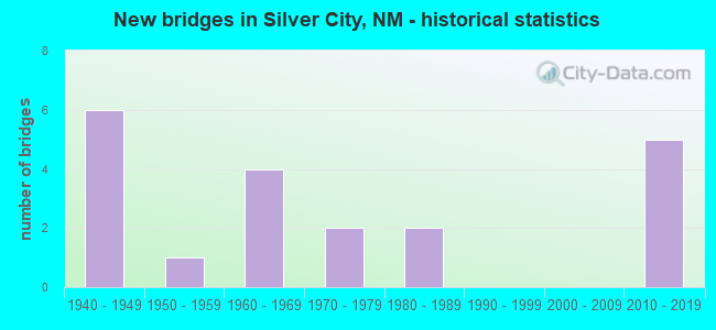
- New bridges - historical statistics
- 61940-1949
- 11950-1959
- 41960-1969
- 21970-1979
- 21980-1989
- 52010-2019


- Bridge Condition - Deck
- 87.5%Good
- 12.5%Fair

- Bridge Condition - Superstructure
- 75.0%Good
- 12.5%Satisfactory
- 12.5%Fair

- Bridge Condition - Substructure
- 62.5%Good
- 37.5%Satisfactory

- Bridge Condition - Channel
- 50.0%Good
- 44.4%Satisfactory
- 5.6%Fair

- Bridge Condition - Culverts
- 45.5%Good
- 36.4%Satisfactory
- 9.1%Fair
- 9.1%Poor
Find on map >> Show street view
Structure Number: 5336, Location: 4.6 M NW OF NM-356/BAYARD (Lat: 32.781256, Lng: -108.193933), Route carried "on" structure: US 180, Year Built: 1948, Status: Open, Structure Length: 0.90m (2.95ft), Average Daily Traffic: 11,699 (year 2020), Truck Traffic: 7%, Average Future Daily Traffic: 16,464 (year 2040), Design Load: HS 20, Features Intersected: RIO DE ARENAS
Minimum Vertical Clearance: 30+ m (98+ ft), Kilometerpoint: 190.063, Lanes on structure: 4, Base Highway Network: Yes, Owner: State Highway Agency, Approaching Roadway Width: 19.6m (64.3ft), Skew: 4 degrees, Material/Design: Concrete continuous, Design/Construction: Culvert, Number Of Spans In Main Unit: 2, Length of Maximum Span: 3.0m (9.8ft)
Condition: Channel: Good, Culverts: Good, Inventory Rating: 32.7 metric tons, Method Used To Determine Inventory Rating: Load Factor (LF), Structural Evaluation: Better than present minimum criteria, Waterway Adequacy: Equal to present desirable criteria, Approach Roadway Alignment: Equal to present desirable criteria, Length Of Structure Improvement: 1.01m (3.31ft), Designated Inspection Frequency: Every 24 months, Inspection Date: April 2021, Bridge Improvement Cost: $166,000, Roadway Improvement Cost: $16,000, Total Project Cost: $249,000
Find on map >> Show street view
Structure Number: 5337, Location: 4.9 M NW OF NM-356/BAYARD (Lat: 32.782172, Lng: -108.200083), Route carried "on" structure: US 180, Year Built: 1948, Status: Open, Structure Length: 2.75m (9.02ft), Average Daily Traffic: 11,699 (year 2020), Truck Traffic: 7%, Average Future Daily Traffic: 16,464 (year 2040), Design Load: HS 20, Features Intersected: UNNAMED WATERWAY
Minimum Vertical Clearance: 30+ m (98+ ft), Kilometerpoint: 189.741, Lanes on structure: 4, Base Highway Network: Yes, Owner: State Highway Agency, Approaching Roadway Width: 21.2m (69.6ft), Skew: 4 degrees, Material/Design: Concrete continuous, Design/Construction: Culvert, Number Of Spans In Main Unit: 6, Length of Maximum Span: 3.0m (9.8ft)
Condition: Channel: Good, Culverts: Good, Operating Rating: 53.9 metric tons, Method Used To Determine Operating Rating: Load Factor (LF), Inventory Rating: 32.7 metric tons, Method Used To Determine Inventory Rating: Load Factor (LF), Structural Evaluation: Better than present minimum criteria, Waterway Adequacy: Equal to present minimum criteria, Approach Roadway Alignment: Equal to present desirable criteria, Length Of Structure Improvement: 2.87m (9.42ft), Designated Inspection Frequency: Every 24 months, Inspection Date: April 2021, Bridge Improvement Cost: $617,000, Roadway Improvement Cost: $61,000, Total Project Cost: $925,000
Find on map >> Show street view
Structure Number: 5338, Location: 5.9 M NW OF NM-356/BAYARD (Lat: 32.784147, Lng: -108.216525), Route carried "on" structure: US 180, Year Built: 1948, Status: Open, Structure Length: 0.90m (2.95ft), Average Daily Traffic: 11,699 (year 2020), Truck Traffic: 7%, Average Future Daily Traffic: 16,464 (year 2040), Design Load: HS 20, Features Intersected: UNNAMED WATERWAY
Minimum Vertical Clearance: 30+ m (98+ ft), Kilometerpoint: 187.971, Lanes on structure: 4, Base Highway Network: Yes, Owner: State Highway Agency, Approaching Roadway Width: 23.2m (76.1ft), Skew: 24 degrees, Material/Design: Concrete continuous, Design/Construction: Culvert, Number Of Spans In Main Unit: 2, Length of Maximum Span: 3.0m (9.8ft)
Condition: Channel: Satisfactory, Culverts: Good, Operating Rating: 83.3 metric tons, Method Used To Determine Operating Rating: Load Factor (LF), Inventory Rating: 32.7 metric tons, Method Used To Determine Inventory Rating: Load Factor (LF), Structural Evaluation: Better than present minimum criteria, Waterway Adequacy: Equal to present desirable criteria, Approach Roadway Alignment: Equal to present desirable criteria, Length Of Structure Improvement: 0.98m (3.22ft), Designated Inspection Frequency: Every 24 months, Inspection Date: May 2021, Bridge Improvement Cost: $233,000, Roadway Improvement Cost: $23,000, Total Project Cost: $350,000
Find on map >> Show street view
Structure Number: 5339, Location: 7.0 M NW OF NM-356/BAYARD (Lat: 32.786028, Lng: -108.235406), Route carried "on" structure: US 180, Year Built: 1948, Status: Open, Structure Length: 1.00m (3.28ft), Average Daily Traffic: 11,699 (year 2020), Truck Traffic: 7%, Average Future Daily Traffic: 16,464 (year 2040), Design Load: HS 20, Features Intersected: WEST CANYON
Minimum Vertical Clearance: 30+ m (98+ ft), Kilometerpoint: 186.169, Lanes on structure: 4, Base Highway Network: Yes, Owner: State Highway Agency, Approaching Roadway Width: 21.2m (69.6ft), Skew: 20 degrees, Material/Design: Concrete continuous, Design/Construction: Culvert, Number Of Spans In Main Unit: 3, Length of Maximum Span: 3.0m (9.8ft)
Condition: Channel: Satisfactory, Culverts: Good, Operating Rating: 89.8 metric tons, Method Used To Determine Operating Rating: Load Factor (LF), Inventory Rating: 32.7 metric tons, Method Used To Determine Inventory Rating: Load Factor (LF), Structural Evaluation: Better than present minimum criteria, Waterway Adequacy: Equal to present desirable criteria, Approach Roadway Alignment: Equal to present desirable criteria, Length Of Structure Improvement: 1.04m (3.41ft), Designated Inspection Frequency: Every 24 months, Inspection Date: April 2021, Bridge Improvement Cost: $178,000, Roadway Improvement Cost: $17,000, Total Project Cost: $267,000
Find on map >> Show street view
Structure Number: 534, Location: 8.9 M NW OF JCT NM-356 (Lat: 32.782956, Lng: -108.267044), Route carried "on" structure: US 180, Year Built: 1948, Status: Open, Structure Length: 1.81m (5.94ft), Average Daily Traffic: 21,467 (year 2020), Truck Traffic: 7%, Average Future Daily Traffic: 30,209 (year 2040), Design Load: HS 20, Features Intersected: PINOS ALTOS CREEK
Minimum Vertical Clearance: 30+ m (98+ ft), Kilometerpoint: 183.143, Lanes on structure: 4, Base Highway Network: Yes, Owner: State Highway Agency, Approaching Roadway Width: 20.1m (65.9ft), Skew: 24 degrees, Material/Design: Concrete continuous, Design/Construction: Culvert, Number Of Spans In Main Unit: 4, Length of Maximum Span: 3.0m (9.8ft)
Condition: Channel: Satisfactory, Culverts: Fair, Operating Rating: 89.8 metric tons, Method Used To Determine Operating Rating: Load Factor (LF), Inventory Rating: 32.7 metric tons, Method Used To Determine Inventory Rating: Load Factor (LF), Structural Evaluation: Somewhat better than minimum adequacy, Waterway Adequacy: Equal to present desirable criteria, Approach Roadway Alignment: Equal to present desirable criteria, Length Of Structure Improvement: 1.86m (6.10ft), Designated Inspection Frequency: Every 24 months, Inspection Date: January 2021, Bridge Improvement Cost: $442,000, Roadway Improvement Cost: $44,000, Total Project Cost: $663,000
Find on map >> Show street view
Structure Number: 6328, Location: 0.3 MI W US-180/SILVERCTY (Lat: 32.775575, Lng: -108.274183), Route carried "on" structure: State highway 90, Year Built: 1961, Status: Open, Structure Length: 0.79m (2.59ft), Average Daily Traffic: 7,441 (year 2020), Truck Traffic: 7%, Average Future Daily Traffic: 8,334 (year 2040), Design Load: HS 20, Features Intersected: PINOS ALTOS CREEK
Minimum Vertical Clearance: 30+ m (98+ ft), Kilometerpoint: 68.043, Lanes on structure: 4, Base Highway Network: Yes, Owner: State Highway Agency, Approaching Roadway Width: 20.7m (67.9ft), Skew: 3 degrees, Material/Design: Concrete continuous, Design/Construction: Culvert, Number Of Spans In Main Unit: 2, Length of Maximum Span: 3.0m (9.8ft), Curb or Sidewalk Widths: Left: 1.7m (5.6ft), Right: 1.7m (5.6ft)
Condition: Channel: Fair, Culverts: Poor, Operating Rating: 39.2 metric tons, Method Used To Determine Operating Rating: Load Factor (LF), Inventory Rating: 32.7 metric tons, Method Used To Determine Inventory Rating: Load Factor (LF), Structural Evaluation: Meets minimum limits, Waterway Adequacy: Equal to present minimum criteria, Approach Roadway Alignment: Equal to present desirable criteria, Length Of Structure Improvement: 0.88m (2.89ft), Designated Inspection Frequency: Every 24 months, Inspection Date: March 2020, Bridge Improvement Cost: $183,000, Roadway Improvement Cost: $18,000, Total Project Cost: $274,000 ( Estimate for 2030)
Find on map >> Show street view
Structure Number: 6431, Location: 0.7 MI W OF JCT NM-90 (Lat: 32.781653, Lng: -108.286708), Route carried "on" structure: US 180, Year Built: 1963, Status: Open, Structure Length: 0.77m (2.53ft), Average Daily Traffic: 2,699 (year 2020), Truck Traffic: 7%, Average Future Daily Traffic: 3,797 (year 2040), Design Load: HS 20, Features Intersected: MISSISSIPPI STREET
Minimum Vertical Clearance: 30+ m (98+ ft), Kilometerpoint: 181.099, Lanes on structure: 4, Lanes under structure: 2, Base Highway Network: Yes, Owner: State Highway Agency, Approaching Roadway Width: 19.1m (62.7ft), Material/Design: Concrete, Design/Construction: Culvert, Number Of Spans In Main Unit: 1, Length of Maximum Span: 7.7m (25.3ft)
Condition: Culverts: Satisfactory, Operating Rating: 76.7 metric tons, Method Used To Determine Operating Rating: Load Factor (LF), Inventory Rating: 32.7 metric tons, Method Used To Determine Inventory Rating: Load Factor (LF), Structural Evaluation: Equal to present minimum criteria, Underclear: High priority of corrective action, Approach Roadway Alignment: Equal to present desirable criteria, Length Of Structure Improvement: 0.76m (2.49ft), Designated Inspection Frequency: Every 24 months, Inspection Date: April 2021, Bridge Improvement Cost: $20,000, Roadway Improvement Cost: $2,000, Total Project Cost: $24,000
Find on map >> Show street view
Structure Number: 7168, Location: 0.04 MI W OF JCT NM-90 (Lat: 32.774422, Lng: -108.274978), Route carried "on" structure: City street 4843, Year Built: 1964, Status: Open, Structure Length: 2.76m (9.06ft), Average Daily Traffic: 2,130 (year 2020), Truck Traffic: 6%, Average Future Daily Traffic: 3,471 (year 2040), Design Load: HS 20, Features Intersected: SAN VICENTE CREEK
Minimum Vertical Clearance: 30+ m (98+ ft), Kilometerpoint: 0.000, Lanes on structure: 2, Owner: City or Municipal Highway Agency, Approaching Roadway Width: 7.3m (24.0ft), Material/Design: Steel, Design/Construction: Stringer/Multi-beam, Number Of Spans In Main Unit: 1, Length of Maximum Span: 26.6m (87.3ft), Curb or Sidewalk Widths: Left: 1.5m (4.9ft), Right: 1.5m (4.9ft), Curb-To-Curb Width: 7.3m (24.0ft), Out-to-Out Width: 10.4m (34.1ft)
Condition: Deck: Good, Superstructure: Satisfactory, Substructure: Satisfactory, Channel: Satisfactory, Operating Rating: 50.6 metric tons, Method Used To Determine Operating Rating: Load Factor (LF), Inventory Rating: 32.7 metric tons, Method Used To Determine Inventory Rating: Load Factor (LF), Structural Evaluation: Equal to present minimum criteria, Deck Geometry: High priority of replacement, Waterway Adequacy: Equal to present desirable criteria, Approach Roadway Alignment: Equal to present desirable criteria, Length Of Structure Improvement: 2.77m (9.09ft), Designated Inspection Frequency: Every 24 months, Inspection Date: June 2021, Bridge Improvement Cost: $139,000, Roadway Improvement Cost: $13,000, Total Project Cost: $208,000 ( Estimate for 2030), Deck Structure Type: Concrete Cast-file-Place
Find on map >> Show street view
Structure Number: 7309, Location: 42.7 MI E OF US-70/NM-90 (Lat: 32.769711, Lng: -108.275872), Route carried "on" structure: City street 4844, Year Built: 1972, Status: Open, Structure Length: 4.03m (13.22ft), Average Daily Traffic: 2,896 (year 2020), Truck Traffic: 7%, Average Future Daily Traffic: 4,718 (year 2040), Features Intersected: SAN VICENTE ARROYO
Minimum Vertical Clearance: 30+ m (98+ ft), Kilometerpoint: 0.000, Lanes on structure: 2, Base Highway Network: Yes, Owner: City or Municipal Highway Agency, Approaching Roadway Width: 15.8m (51.8ft), Skew: 2 degrees, Material/Design: Steel, Design/Construction: Stringer/Multi-beam, Number Of Spans In Main Unit: 3, Length of Maximum Span: 24.7m (81.0ft), Curb or Sidewalk Widths: Left: 1.6m (5.2ft), Right: 1.6m (5.2ft), Curb-To-Curb Width: 15.8m (51.8ft), Out-to-Out Width: 19.2m (63.0ft)
Condition: Deck: Fair, Superstructure: Fair, Substructure: Satisfactory, Channel: Good, Operating Rating: 52.7 metric tons, Method Used To Determine Operating Rating: Load Factor (LF), Inventory Rating: 32.8 metric tons, Method Used To Determine Inventory Rating: Load Factor (LF), Structural Evaluation: Somewhat better than minimum adequacy, Deck Geometry: Superior to present desirable criteria, Waterway Adequacy: Equal to present desirable criteria, Approach Roadway Alignment: Equal to present desirable criteria, Designated Inspection Frequency: Every 24 months, Inspection Date: June 2021, Deck Structure Type: Concrete Cast-file-Place
Find on map >> Show street view
Structure Number: 7556, Location: 0.12 MI E OF JCT NM-90 (Lat: 32.777236, Lng: -108.271694), Route carried "on" structure: City street 5850, Year Built: 1953, Status: Open, Structure Length: 0.96m (3.15ft), Average Daily Traffic: 1,944 (year 2020), Truck Traffic: 7%, Average Future Daily Traffic: 3,169 (year 2040), Design Load: H 15, Features Intersected: PINOS ALTOS CREEK
Minimum Vertical Clearance: 30+ m (98+ ft), Kilometerpoint: 0.000, Lanes on structure: 2, Owner: City or Municipal Highway Agency, Approaching Roadway Width: 12.4m (40.7ft), Material/Design: Concrete continuous, Design/Construction: Culvert, Number Of Spans In Main Unit: 3, Length of Maximum Span: 3.0m (9.8ft), Curb or Sidewalk Widths: Left: 1.4m (4.6ft), Right: 1.4m (4.6ft)
Condition: Channel: Satisfactory, Culverts: Satisfactory, Operating Rating: 53.9 metric tons, Method Used To Determine Operating Rating: Load Factor (LF), Inventory Rating: 32.7 metric tons, Method Used To Determine Inventory Rating: Load Factor (LF), Structural Evaluation: Equal to present minimum criteria, Waterway Adequacy: Equal to present minimum criteria, Approach Roadway Alignment: Equal to present desirable criteria, Designated Inspection Frequency: Every 24 months, Inspection Date: April 2020
Find on map >> Show street view
Structure Number: 762, Location: 0.25 MI W OF JCT NM-90 (Lat: 32.777886, Lng: -108.278344), Route carried "on" structure: City street 17000, Year Built: 1948, Status: Open, Structure Length: 1.62m (5.31ft), Average Daily Traffic: 1,944 (year 2020), Truck Traffic: 7%, Average Future Daily Traffic: 3,169 (year 2040), Design Load: H 15, Features Intersected: SILVA CREEK, Facility Carried by Structure: 17-Z000
Minimum Vertical Clearance: 30+ m (98+ ft), Kilometerpoint: 0.000, Lanes on structure: 2, Owner: City or Municipal Highway Agency, Approaching Roadway Width: 19.7m (64.6ft), Skew: 3 degrees, Material/Design: Steel, Design/Construction: Culvert, Number Of Spans In Main Unit: 2, Length of Maximum Span: 7.6m (24.9ft), Curb or Sidewalk Widths: Left: 1.5m (4.9ft), Right: 1.5m (4.9ft)
Condition: Channel: Satisfactory, Culverts: Satisfactory, Operating Rating: 71.8 metric tons, Method Used To Determine Operating Rating: Load Factor (LF), Inventory Rating: 32.7 metric tons, Method Used To Determine Inventory Rating: Load Factor (LF), Structural Evaluation: Equal to present minimum criteria, Waterway Adequacy: Equal to present desirable criteria, Approach Roadway Alignment: Equal to present desirable criteria, Designated Inspection Frequency: Every 24 months, Inspection Date: April 2021
Find on map >> Show street view
Structure Number: 8334, Location: 0.2 MI S OF US-180 (Lat: 32.779825, Lng: -108.269833), Route carried "on" structure: City street 5835, Year Built: 1977, Status: Open, Structure Length: 1.35m (4.43ft), Average Daily Traffic: 1,467 (year 2020), Truck Traffic: 6%, Average Future Daily Traffic: 2,390 (year 2040), Design Load: H 20, Features Intersected: PINOS ALTO CREEK
Minimum Vertical Clearance: 30+ m (98+ ft), Kilometerpoint: 0.000, Lanes on structure: 2, Owner: City or Municipal Highway Agency, Approaching Roadway Width: 14.2m (46.6ft), Skew: 4 degrees, Material/Design: Concrete continuous, Design/Construction: Culvert, Number Of Spans In Main Unit: 3, Length of Maximum Span: 3.0m (9.8ft), Curb or Sidewalk Widths: Left: 1.3m (4.3ft), Right: 1.3m (4.3ft)
Condition: Channel: Satisfactory, Culverts: Satisfactory, Operating Rating: 39.2 metric tons, Method Used To Determine Operating Rating: Load Factor (LF), Inventory Rating: 32.7 metric tons, Method Used To Determine Inventory Rating: Load Factor (LF), Structural Evaluation: Equal to present minimum criteria, Waterway Adequacy: Better than present minimum criteria, Approach Roadway Alignment: Equal to present desirable criteria, Designated Inspection Frequency: Every 24 months, Inspection Date: April 2020
Find on map >> Show street view
Structure Number: 8649, Location: 3.2 MI NE NM90/BRKN-ARROW (Lat: 32.729997, Lng: -108.256778), Route carried "on" structure: City street 17000, Year Built: 1988, Status: Open, Structure Length: 1.90m (6.23ft), Average Daily Traffic: 153 (year 2020), Average Future Daily Traffic: 252 (year 2040), Design Load: HS 20, Features Intersected: SAN VICENTE ARROYO, Facility Carried by Structure: 17-Z000
Minimum Vertical Clearance: 30+ m (98+ ft), Kilometerpoint: 0.000, Lanes on structure: 2, Owner: County Highway Agency, Approaching Roadway Width: 7.5m (24.6ft), Material/Design: Prestressed concrete, Design/Construction: Box Beam or Girders - Multiple, Number Of Spans In Main Unit: 1, Length of Maximum Span: 16.6m (54.5ft), Curb-To-Curb Width: 7.6m (24.9ft), Out-to-Out Width: 8.6m (28.2ft)
Condition: Deck: Good, Superstructure: Good, Substructure: Satisfactory, Channel: Good, Operating Rating: 63.7 metric tons, Method Used To Determine Operating Rating: Load Factor (LF), Inventory Rating: 32.7 metric tons, Method Used To Determine Inventory Rating: Load Factor (LF), Structural Evaluation: Equal to present minimum criteria, Deck Geometry: Somewhat better than minimum adequacy, Waterway Adequacy: Better than present minimum criteria, Approach Roadway Alignment: Equal to present desirable criteria, Designated Inspection Frequency: Every 24 months, Inspection Date: April 2020, Deck Structure Type: Concrete Cast-file-Place, Wearing Surface/Protective System: Deck Protection: Epoxy Coated Reinforcing
Find on map >> Show street view
Structure Number: 9658, Location: 41.4 MI E OF JCT US-70 (Lat: 32.765383, Lng: -108.275086), Route carried "on" structure: State highway 90, Year Built: 2016, Status: Open, Structure Length: 16.73m (54.89ft), Average Daily Traffic: 3,891 (year 2020), Truck Traffic: 7%, Average Future Daily Traffic: 5,476 (year 2040), Design Load: HS 20, Features Intersected: SAN VICENTE ARROYO/ROAD
Minimum Vertical Clearance: 30.45m (99.90ft), Kilometerpoint: 66.627, Lanes on structure: 4, Lanes under structure: 2, Base Highway Network: Yes, Owner: State Highway Agency, Approaching Roadway Width: 19.3m (63.3ft), Material/Design: Prestressed concrete continuous, Design/Construction: Stringer/Multi-beam, Number Of Spans In Main Unit: 5, Length of Maximum Span: 35.9m (117.8ft), Curb-To-Curb Width: 16.0m (52.5ft), Out-to-Out Width: 19.7m (64.6ft)
Condition: Deck: Good, Superstructure: Good, Substructure: Good, Channel: Good, Operating Rating: 86.1 metric tons, Method Used To Determine Operating Rating: Load Factor (LF), Inventory Rating: 47.4 metric tons, Method Used To Determine Inventory Rating: Load Factor (LF), Structural Evaluation: Better than present minimum criteria, Deck Geometry: Meets minimum limits, Underclear: High priority of corrective action, Waterway Adequacy: Superior to present desirable criteria, Approach Roadway Alignment: Equal to present desirable criteria, Designated Inspection Frequency: Every 24 months, Inspection Date: September 2020, Wearing Surface/Protective System: Deck Protection: Epoxy Coated Reinforcing
Find on map >> Show street view
Structure Number: 968, Location: 7.3 miles west jct I-25 (Lat: 32.972053, Lng: -107.434003), Route carried "on" structure: US 152, Year Built: 1988, Status: Open, Structure Length: 2.47m (8.10ft), Average Daily Traffic: 389 (year 2020), Truck Traffic: 21%, Average Future Daily Traffic: 335 (year 2040), Design Load: HS 20, Features Intersected: Unnamed Waterway
Minimum Vertical Clearance: 30+ m (98+ ft), Kilometerpoint: 93.422, Lanes on structure: 2, Base Highway Network: Yes, Owner: State Highway Agency, Approaching Roadway Width: 7.0m (23.0ft), Skew: 2 degrees, Material/Design: Steel, Design/Construction: Culvert, Number Of Spans In Main Unit: 1, Number Of Approach Spans: 6, Length of Maximum Span: 2.8m (9.2ft)
Condition: Channel: Satisfactory, Culverts: Good, Operating Rating: 53.9 metric tons, Method Used To Determine Operating Rating: Load Factor (LF), Inventory Rating: 32.7 metric tons, Method Used To Determine Inventory Rating: Load Factor (LF), Structural Evaluation: Better than present minimum criteria, Waterway Adequacy: Equal to present desirable criteria, Approach Roadway Alignment: Equal to present desirable criteria, Designated Inspection Frequency: Every 24 months, Inspection Date: September 2020
Find on map >> Show street view
Structure Number: 9713, Location: 8.59 M N of US 180 (Lat: 33.393947, Lng: -10.802428), Route carried "on" structure: State highway 159, Year Built: 2017, Status: Open, Structure Length: 1.19m (3.90ft), Average Daily Traffic: 100 (year 2019), Average Future Daily Traffic: 150 (year 2039), Design Load: HS 20, Features Intersected: Deadwood Gulch
Minimum Vertical Clearance: 30+ m (98+ ft), Kilometerpoint: 13.824, Lanes on structure: 2, Toll: On toll road, Owner: State Highway Agency, Approaching Roadway Width: 7.8m (25.6ft), Material/Design: Concrete continuous, Design/Construction: Slab, Number Of Spans In Main Unit: 1, Length of Maximum Span: 11.9m (39.0ft), Curb-To-Curb Width: 6.0m (19.7ft), Out-to-Out Width: 9.4m (30.8ft)
Condition: Deck: Good, Superstructure: Good, Substructure: Good, Channel: Good, Operating Rating: 53.8 metric tons, Method Used To Determine Operating Rating: Load Factor (LF), Inventory Rating: 32.7 metric tons, Method Used To Determine Inventory Rating: Load Factor (LF), Structural Evaluation: Better than present minimum criteria, Deck Geometry: Meets minimum limits, Waterway Adequacy: Meets minimum limits, Approach Roadway Alignment: Equal to present minimum criteria, Designated Inspection Frequency: Every 24 months, Inspection Date: October 2021, Deck Structure Type: Concrete Cast-file-Place, Wearing Surface/Protective System: Wearing Surface: Monolithic Concrete, Deck Protection: Epoxy Coated Reinforcing
Find on map >> Show street view
Structure Number: 9714, Location: 9.1 M N of US-180 (Lat: 33.397856, Lng: -108.797892), Route carried "on" structure: State highway 159, Year Built: 2017, Status: Open, Structure Length: 1.04m (3.41ft), Average Daily Traffic: 150 (year 2018), Average Future Daily Traffic: 200 (year 2038), Design Load: HS 20, Features Intersected: Silver Creek
Minimum Vertical Clearance: 30+ m (98+ ft), Kilometerpoint: 0.000, Lanes on structure: 2, Owner: State Highway Agency, Approaching Roadway Width: 5.1m (16.7ft), Material/Design: Concrete, Design/Construction: Slab, Number Of Spans In Main Unit: 1, Length of Maximum Span: 10.4m (34.1ft), Curb-To-Curb Width: 5.1m (16.7ft), Out-to-Out Width: 8.4m (27.6ft)
Condition: Deck: Good, Superstructure: Good, Substructure: Good, Channel: Good, Operating Rating: 53.1 metric tons, Method Used To Determine Operating Rating: Load Factor (LF), Inventory Rating: 31.8 metric tons, Method Used To Determine Inventory Rating: Load Factor (LF), Structural Evaluation: Better than present minimum criteria, Deck Geometry: High priority of replacement, Waterway Adequacy: Meets minimum limits, Approach Roadway Alignment: Equal to present minimum criteria, Designated Inspection Frequency: Every 24 months, Inspection Date: October 2021, Deck Structure Type: Concrete Cast-file-Place, Wearing Surface/Protective System: Wearing Surface: Monolithic Concrete, Deck Protection: Epoxy Coated Reinforcing
Find on map >> Show street view
Structure Number: 9715, Location: 8.8 Miles N of US-180 (Lat: 33.403817, Lng: -108.800750), Route carried "on" structure: State highway 159, Year Built: 2017, Status: Open, Structure Length: 1.19m (3.90ft), Average Daily Traffic: 180 (year 2019), Average Future Daily Traffic: 208 (year 2039), Design Load: HS 20, Features Intersected: South Fork
Minimum Vertical Clearance: 30+ m (98+ ft), Kilometerpoint: 14.162, Lanes on structure: 2, Base Highway Network: Yes, Owner: State Highway Agency, Approaching Roadway Width: 7.3m (24.0ft), Material/Design: Concrete, Design/Construction: Slab, Number Of Spans In Main Unit: 1, Length of Maximum Span: 11.9m (39.0ft), Curb-To-Curb Width: 6.0m (19.7ft), Out-to-Out Width: 9.4m (30.8ft)
Condition: Deck: Good, Superstructure: Good, Substructure: Good, Channel: Good, Operating Rating: 80.0 metric tons, Method Used To Determine Operating Rating: Load Factor (LF), Inventory Rating: 48.6 metric tons, Method Used To Determine Inventory Rating: Load Factor (LF), Structural Evaluation: Better than present minimum criteria, Deck Geometry: High priority of corrective action, Waterway Adequacy: Meets minimum limits, Approach Roadway Alignment: Equal to present minimum criteria, Designated Inspection Frequency: Every 24 months, Inspection Date: October 2021, Deck Structure Type: Concrete Cast-file-Place, Wearing Surface/Protective System: Wearing Surface: Monolithic Concrete, Deck Protection: Epoxy Coated Reinforcing
Find on map >> Show street view
Structure Number: 9717, Location: 3.4 MI NW OF GRANT CL (Lat: 33.226014, Lng: -108.251281), Route carried "on" structure: State highway 15, Year Built: 2016, Status: Open, Structure Length: 6.10m (20.01ft), Average Daily Traffic: 88 (year 2020), Truck Traffic: 20%, Average Future Daily Traffic: 75 (year 2040), Design Load: HS 20, Features Intersected: WEST FORK GILA RIVER
Minimum Vertical Clearance: 30+ m (98+ ft), Kilometerpoint: 66.659, Lanes on structure: 2, Owner: State Highway Agency, Approaching Roadway Width: 7.7m (25.3ft), Material/Design: Prestressed concrete continuous, Design/Construction: Stringer/Multi-beam, Number Of Spans In Main Unit: 3, Length of Maximum Span: 20.1m (65.9ft), Curb-To-Curb Width: 5.9m (19.4ft), Out-to-Out Width: 8.8m (28.9ft)
Condition: Deck: Good, Superstructure: Good, Substructure: Good, Channel: Good, Operating Rating: 59.8 metric tons, Method Used To Determine Operating Rating: Load Factor (LF), Inventory Rating: 27.6 metric tons, Method Used To Determine Inventory Rating: Load Factor (LF), Structural Evaluation: Equal to present minimum criteria, Deck Geometry: Meets minimum limits, Waterway Adequacy: Meets minimum limits, Approach Roadway Alignment: Equal to present minimum criteria, Designated Inspection Frequency: Every 24 months, Inspection Date: October 2021, Deck Structure Type: Concrete Cast-file-Place, Wearing Surface/Protective System: Wearing Surface: Bituminous, Membrane: Epoxy, Deck Protection: Epoxy Coated Reinforcing
Find on map >> Show street view
Structure Number: 6431, Location: 0.7 MI W OF JCT NM-90 (Lat: 32.781653, Lng: -108.286708), Route carried "under" structure: City street 17000, Year Built: 1963, Structure Length: 0. m, Average Daily Traffic: 148 (year 2020), Features Intersected: MISSISSIPPI STREET, Facility Carried by Structure: US-180
Minimum Vertical Clearance: 4.25m (13.94ft), Kilometerpoint: 0.000, Lanes on structure: 4, Lanes under structure: 2, Material/Design: Concrete, Design/Construction: Culvert, Length of Maximum Span: 7.7m (25.3ft)