Bridge Statistics for Sealy, Texas (TX)
Condition, Traffic, Stress, Structural Evaluation, Project Costs
- National Bridge Inventory (NBI) Statistics
- 41Number of bridges
- 410ft / 125mTotal length
- $820,000Total costs
- 443,361Total average daily traffic
- 109,904Total average daily truck traffic
- National Bridge Inventory (NBI) Registered Bridges for Sealy
- No street view available for this location
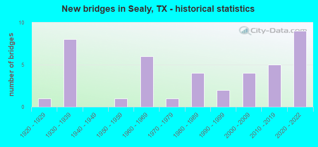
- New bridges - historical statistics
- 11920-1929
- 81930-1939
- 11950-1959
- 61960-1969
- 11970-1979
- 41980-1989
- 21990-1999
- 42000-2009
- 52010-2019
- 92020-2022

- Reconstructed bridges - Historical Statistics
- 11950-1959
- 41960-1969
- 11970-1979
- 01980-1989
- 01990-1999
- 32000-2009
- 12010-2019


- Bridge Condition - Deck
- 47.1%Very good
- 23.5%Good
- 29.4%Satisfactory

- Bridge Condition - Superstructure
- 52.9%Very good
- 23.5%Good
- 23.5%Satisfactory

- Bridge Condition - Substructure
- 47.1%Very good
- 23.5%Good
- 17.6%Satisfactory
- 5.9%Fair
- 5.9%Critical

- Bridge Condition - Channel
- 11.4%Very good
- 45.7%Good
- 40.0%Satisfactory
- 2.9%Poor

- Bridge Condition - Culverts
- 14.3%Very good
- 28.6%Good
- 57.1%Satisfactory
Find on map >> Show street view
Structure Number: 130080018702001, Location: 3.30 MI NW OF SH 159 (Lat: 29.993867, Lng: -96.302181), Route carried "on" structure: State highway 36, Year Built: 1927, Year Reconstructed: 1956, Status: Open, Structure Length: 0.67m (2.20ft), Average Daily Traffic: 6,088 (year 2020), Truck Traffic: 21%, Average Future Daily Traffic: 7,790 (year 2033), Features Intersected: LONG BRANCH
Minimum Vertical Clearance: 30+ m (98+ ft), Kilometerpoint: 12.151, Lanes on structure: 2, Owner: State Highway Agency, Approaching Roadway Width: 13.1m (43.0ft), Material/Design: Concrete, Design/Construction: Culvert, Number Of Spans In Main Unit: 2, Length of Maximum Span: 3.0m (9.8ft), Curb-To-Curb Width: 13.1m (43.0ft), Out-to-Out Width: 13.8m (45.3ft)
Condition: Channel: Satisfactory, Culverts: Satisfactory, Operating Rating: 39.9 metric tons, Method Used To Determine Operating Rating: Load Factor (LF), Inventory Rating: 23.6 metric tons, Method Used To Determine Inventory Rating: Load Factor (LF), Structural Evaluation: Somewhat better than minimum adequacy, Deck Geometry: Somewhat better than minimum adequacy, Waterway Adequacy: Equal to present minimum criteria, Approach Roadway Alignment: Equal to present desirable criteria, Designated Inspection Frequency: Every 24 months, Inspection Date: Febuary 2021, Deck Structure Type: Concrete Cast-file-Place
Find on map >> Show street view
Structure Number: 130080018703007, Location: 0.80 MI S OF FM 331 (Lat: 29.828950, Lng: -96.167269), Route carried "on" structure: State highway 36, Year Built: 1932, Year Reconstructed: 2011, Status: Open, Structure Length: 1.16m (3.81ft), Average Daily Traffic: 10,715 (year 2020), Truck Traffic: 16%, Average Future Daily Traffic: 13,160 (year 2033), Design Load: H 15, Features Intersected: DRAW
Minimum Vertical Clearance: 30+ m (98+ ft), Kilometerpoint: 5.642, Lanes on structure: 4, Owner: State Highway Agency, Approaching Roadway Width: 23.8m (78.1ft), Skew: 9 degrees, Material/Design: Concrete, Design/Construction: Culvert, Number Of Spans In Main Unit: 8, Length of Maximum Span: 1.2m (3.9ft), Out-to-Out Width: 40.5m (132.9ft)
Condition: Channel: Satisfactory, Culverts: Satisfactory, Operating Rating: 39.9 metric tons, Method Used To Determine Operating Rating: Load Factor (LF), Inventory Rating: 23.6 metric tons, Method Used To Determine Inventory Rating: Load Factor (LF), Structural Evaluation: Somewhat better than minimum adequacy, Waterway Adequacy: Equal to present minimum criteria, Approach Roadway Alignment: Equal to present desirable criteria, Designated Inspection Frequency: Every 24 months, Inspection Date: Febuary 2021
Find on map >> Show street view
Structure Number: 130080018703008, Location: 2.90 MI S OF FM 331 (Lat: 29.799089, Lng: -96.161711), Route carried "on" structure: State highway 36, Year Built: 1932, Year Reconstructed: 2011, Status: Open, Structure Length: 2.44m (8.01ft), Average Daily Traffic: 10,715 (year 2020), Truck Traffic: 16%, Average Future Daily Traffic: 13,160 (year 2033), Design Load: H 15, Features Intersected: BULLINGER CREEK
Minimum Vertical Clearance: 30+ m (98+ ft), Kilometerpoint: 8.988, Lanes on structure: 5, Owner: State Highway Agency, Approaching Roadway Width: 20.7m (67.9ft), Material/Design: Concrete, Design/Construction: Tee Beam, Number Of Spans In Main Unit: 3, Length of Maximum Span: 7.9m (25.9ft), Curb-To-Curb Width: 20.5m (67.3ft), Out-to-Out Width: 21.3m (69.9ft)
Condition: Deck: Good, Superstructure: Good, Substructure: Satisfactory, Channel: Satisfactory, Operating Rating: 59.0 metric tons, Method Used To Determine Operating Rating: Load Factor (LF), Inventory Rating: 35.4 metric tons, Method Used To Determine Inventory Rating: Load Factor (LF), Structural Evaluation: Equal to present minimum criteria, Deck Geometry: Somewhat better than minimum adequacy, Waterway Adequacy: Equal to present minimum criteria, Approach Roadway Alignment: Equal to present desirable criteria, Designated Inspection Frequency: Every 24 months, Inspection Date: Febuary 2021, Deck Structure Type: Concrete Cast-file-Place, Wearing Surface/Protective System: Wearing Surface: Bituminous
Find on map >> Show street view
Structure Number: 130080018703009, Location: 0.04 MI S OF FM 3013 (Lat: 29.749033, Lng: -96.146956), Route carried "on" structure: State highway 36, Year Built: 1932, Year Reconstructed: 1969, Status: Open, Structure Length: 1.01m (3.31ft), Average Daily Traffic: 15,203 (year 2020), Truck Traffic: 12%, Average Future Daily Traffic: 6,780 (year 2038), Design Load: H 15, Features Intersected: DRAW
Minimum Vertical Clearance: 30+ m (98+ ft), Kilometerpoint: 14.746, Lanes on structure: 3, Owner: State Highway Agency, Approaching Roadway Width: 16.2m (53.1ft), Material/Design: Concrete, Design/Construction: Culvert, Number Of Spans In Main Unit: 5, Length of Maximum Span: 1.8m (5.9ft), Curb-To-Curb Width: 17.9m (58.7ft), Out-to-Out Width: 18.5m (60.7ft)
Condition: Channel: Satisfactory, Culverts: Satisfactory, Operating Rating: 39.9 metric tons, Method Used To Determine Operating Rating: Load Factor (LF), Inventory Rating: 23.6 metric tons, Method Used To Determine Inventory Rating: Load Factor (LF), Structural Evaluation: Somewhat better than minimum adequacy, Deck Geometry: Superior to present desirable criteria, Waterway Adequacy: Equal to present minimum criteria, Approach Roadway Alignment: Equal to present desirable criteria, Designated Inspection Frequency: Every 24 months, Inspection Date: January 2021, Deck Structure Type: Concrete Cast-file-Place, Wearing Surface/Protective System: Wearing Surface: Bituminous
Find on map >> Show street view
Structure Number: 13008001870301, Location: 0.47 MI S OF FM 3013 (Lat: 29.742983, Lng: -96.145408), Route carried "on" structure: State highway 36, Year Built: 1932, Year Reconstructed: 1969, Status: Open, Structure Length: 0.82m (2.69ft), Average Daily Traffic: 5,159 (year 2020), Truck Traffic: 12%, Average Future Daily Traffic: 6,780 (year 2038), Design Load: H 15, Features Intersected: DRAW
Minimum Vertical Clearance: 30+ m (98+ ft), Kilometerpoint: 15.435, Lanes on structure: 2, Owner: State Highway Agency, Approaching Roadway Width: 14.0m (45.9ft), Material/Design: Concrete, Design/Construction: Culvert, Number Of Spans In Main Unit: 4, Length of Maximum Span: 1.8m (5.9ft), Curb-To-Curb Width: 20.8m (68.2ft), Out-to-Out Width: 21.2m (69.6ft)
Condition: Channel: Good, Culverts: Satisfactory, Operating Rating: 39.9 metric tons, Method Used To Determine Operating Rating: Load Factor (LF), Inventory Rating: 23.6 metric tons, Method Used To Determine Inventory Rating: Load Factor (LF), Structural Evaluation: Somewhat better than minimum adequacy, Deck Geometry: Superior to present desirable criteria, Waterway Adequacy: Equal to present minimum criteria, Approach Roadway Alignment: Equal to present desirable criteria, Designated Inspection Frequency: Every 24 months, Inspection Date: January 2021, Deck Structure Type: Concrete Cast-file-Place, Wearing Surface/Protective System: Wearing Surface: Bituminous
Find on map >> Show street view
Structure Number: 130080018703015, Location: 0.46 MI S OF IH 10 (Lat: 29.758308, Lng: -96.149903), Route carried "on" structure: State highway 36, Year Built: 1932, Year Reconstructed: 1969, Status: Open, Structure Length: 1.19m (3.90ft), Average Daily Traffic: 15,203 (year 2020), Truck Traffic: 11%, Average Future Daily Traffic: 18,540 (year 2038), Design Load: H 15, Features Intersected: ALLENS CREEK
Minimum Vertical Clearance: 30+ m (98+ ft), Kilometerpoint: 13.665, Lanes on structure: 5, Owner: State Highway Agency, Approaching Roadway Width: 20.7m (67.9ft), Material/Design: Concrete, Design/Construction: Culvert, Number Of Spans In Main Unit: 6, Length of Maximum Span: 1.8m (5.9ft), Curb-To-Curb Width: 20.4m (66.9ft), Out-to-Out Width: 21.1m (69.2ft)
Condition: Channel: Good, Culverts: Satisfactory, Operating Rating: 39.9 metric tons, Method Used To Determine Operating Rating: Load Factor (LF), Inventory Rating: 23.6 metric tons, Method Used To Determine Inventory Rating: Load Factor (LF), Structural Evaluation: Somewhat better than minimum adequacy, Deck Geometry: Somewhat better than minimum adequacy, Waterway Adequacy: Equal to present minimum criteria, Approach Roadway Alignment: Equal to present desirable criteria, Designated Inspection Frequency: Every 24 months, Inspection Date: January 2021, Deck Structure Type: Concrete Cast-file-Place, Wearing Surface/Protective System: Wearing Surface: Bituminous
Find on map >> Show street view
Structure Number: 130080018703016, Location: 1.80 MI S OF FM 331 (Lat: 29.814731, Lng: -96.163600), Route carried "on" structure: State highway 36, Year Built: 1932, Year Reconstructed: 2011, Status: Open, Structure Length: 0.70m (2.30ft), Average Daily Traffic: 10,715 (year 2020), Truck Traffic: 16%, Average Future Daily Traffic: 13,160 (year 2033), Design Load: H 15, Features Intersected: DRAINAGE DITCH
Minimum Vertical Clearance: 30+ m (98+ ft), Kilometerpoint: 7.250, Lanes on structure: 5, Owner: State Highway Agency, Approaching Roadway Width: 25.9m (85.0ft), Material/Design: Concrete, Design/Construction: Culvert, Number Of Spans In Main Unit: 5, Length of Maximum Span: 1.2m (3.9ft), Out-to-Out Width: 30.5m (100.1ft)
Condition: Channel: Satisfactory, Culverts: Satisfactory, Operating Rating: 39.9 metric tons, Method Used To Determine Operating Rating: Load Factor (LF), Inventory Rating: 23.6 metric tons, Method Used To Determine Inventory Rating: Load Factor (LF), Structural Evaluation: Somewhat better than minimum adequacy, Waterway Adequacy: Equal to present minimum criteria, Approach Roadway Alignment: Equal to present desirable criteria, Designated Inspection Frequency: Every 24 months, Inspection Date: Febuary 2021
Find on map >> Show street view
Structure Number: 130080018703017, Location: 0.88 MI S OF FM 3013 (Lat: 29.737058, Lng: -96.143919), Route carried "on" structure: State highway 36, Year Built: 1932, Year Reconstructed: 1969, Status: Open, Structure Length: 1.01m (3.31ft), Average Daily Traffic: 5,159 (year 2020), Truck Traffic: 12%, Average Future Daily Traffic: 6,780 (year 2038), Design Load: H 15, Features Intersected: DRAINAGE DITCH
Minimum Vertical Clearance: 30+ m (98+ ft), Kilometerpoint: 16.101, Lanes on structure: 2, Owner: State Highway Agency, Approaching Roadway Width: 14.0m (45.9ft), Material/Design: Concrete, Design/Construction: Culvert, Number Of Spans In Main Unit: 5, Length of Maximum Span: 1.8m (5.9ft), Curb-To-Curb Width: 20.7m (67.9ft), Out-to-Out Width: 21.1m (69.2ft)
Condition: Channel: Good, Culverts: Satisfactory, Operating Rating: 39.9 metric tons, Method Used To Determine Operating Rating: Load Factor (LF), Inventory Rating: 23.6 metric tons, Method Used To Determine Inventory Rating: Load Factor (LF), Structural Evaluation: Somewhat better than minimum adequacy, Deck Geometry: Superior to present desirable criteria, Waterway Adequacy: Equal to present minimum criteria, Approach Roadway Alignment: Equal to present desirable criteria, Designated Inspection Frequency: Every 24 months, Inspection Date: January 2021, Deck Structure Type: Concrete Cast-file-Place, Wearing Surface/Protective System: Wearing Surface: Bituminous
Find on map >> Show street view
Structure Number: 130080027102204, Location: 7.50 MI W OF SH 36 (Lat: 29.752000, Lng: -96.274100), Route carried "on" structure: Interstate 10, Year Built: 1939, Year Reconstructed: 1984, Status: Open, Structure Length: 0.67m (2.20ft), Average Daily Traffic: 46,316 (year 2019), Truck Traffic: 21%, Average Future Daily Traffic: 54,400 (year 2033), Design Load: H 15, Features Intersected: DRAW
Minimum Vertical Clearance: 30+ m (98+ ft), Kilometerpoint: 2.358, Lanes on structure: 8, Owner: State Highway Agency, Approaching Roadway Width: 38.4m (126.0ft), Skew: 30 degrees, Material/Design: Concrete, Design/Construction: Culvert, Number Of Spans In Main Unit: 4, Length of Maximum Span: 1.5m (4.9ft)
Condition: Channel: Good, Culverts: Good, Operating Rating: 39.9 metric tons, Method Used To Determine Operating Rating: Load Factor (LF), Inventory Rating: 23.6 metric tons, Method Used To Determine Inventory Rating: Load Factor (LF), Structural Evaluation: Somewhat better than minimum adequacy, Waterway Adequacy: Equal to present minimum criteria, Approach Roadway Alignment: Equal to present desirable criteria, Designated Inspection Frequency: Every 24 months, Inspection Date: January 2021
Find on map >> Show street view
Structure Number: 130080027102207, Location: 6.55 MI W OF SH 36 (Lat: 29.753689, Lng: -96.258739), Route carried "on" structure: Interstate 10, Year Built: 1966, Status: Open, Structure Length: 7.62m (25.00ft), Average Daily Traffic: 22,428 (year 2017), Truck Traffic: 21%, Average Future Daily Traffic: 27,200 (year 2033), Design Load: HS 20, Features Intersected: CROOKED BRANCH
Minimum Vertical Clearance: 30+ m (98+ ft), Kilometerpoint: 3.811, Lanes on structure: 2, Owner: State Highway Agency, Approaching Roadway Width: 11.6m (38.1ft), Skew: 2 degrees, Material/Design: Concrete, Design/Construction: Stringer/Multi-beam, Number Of Spans In Main Unit: 6, Length of Maximum Span: 12.8m (42.0ft), Curb-To-Curb Width: 11.5m (37.7ft), Out-to-Out Width: 12.3m (40.4ft)
Condition: Deck: Satisfactory, Superstructure: Satisfactory, Substructure: Fair, Channel: Satisfactory, Operating Rating: 57.1 metric tons, Method Used To Determine Operating Rating: Load Factor (LF), Inventory Rating: 34.5 metric tons, Method Used To Determine Inventory Rating: Load Factor (LF), Structural Evaluation: Somewhat better than minimum adequacy, Deck Geometry: Somewhat better than minimum adequacy, Waterway Adequacy: Equal to present minimum criteria, Approach Roadway Alignment: Equal to present desirable criteria, Designated Inspection Frequency: Every 24 months, Inspection Date: January 2021, Deck Structure Type: Concrete Cast-file-Place, Wearing Surface/Protective System: Wearing Surface: Bituminous
Find on map >> Show street view
Structure Number: 130080027102214, Location: 3.30 MI W OF SH 36 (Lat: 29.761461, Lng: -96.205431), Route carried "on" structure: Interstate 10, Year Built: 1966, Status: Open, Structure Length: 6.37m (20.90ft), Average Daily Traffic: 23,906 (year 2017), Truck Traffic: 21%, Average Future Daily Traffic: 27,200 (year 2033), Design Load: HS 20, Features Intersected: LITTLE BERNARD CREEK
Minimum Vertical Clearance: 30+ m (98+ ft), Kilometerpoint: 9.057, Lanes on structure: 2, Owner: State Highway Agency, Approaching Roadway Width: 12.2m (40.0ft), Skew: 2 degrees, Material/Design: Concrete, Design/Construction: Stringer/Multi-beam, Number Of Spans In Main Unit: 5, Length of Maximum Span: 12.8m (42.0ft), Curb-To-Curb Width: 11.5m (37.7ft), Out-to-Out Width: 12.3m (40.4ft)
Condition: Deck: Satisfactory, Superstructure: Satisfactory, Substructure: Satisfactory, Channel: Satisfactory, Operating Rating: 55.3 metric tons, Method Used To Determine Operating Rating: Load Factor (LF), Inventory Rating: 33.6 metric tons, Method Used To Determine Inventory Rating: Load Factor (LF), Structural Evaluation: Equal to present minimum criteria, Deck Geometry: Somewhat better than minimum adequacy, Waterway Adequacy: Equal to present minimum criteria, Approach Roadway Alignment: Equal to present desirable criteria, Designated Inspection Frequency: Every 24 months, Inspection Date: January 2021, Deck Structure Type: Concrete Cast-file-Place, Wearing Surface/Protective System: Wearing Surface: Bituminous
Find on map >> Show street view
Structure Number: 130080027102218, Location: 0.30 MI W OF SH 36 (Lat: 29.763458, Lng: -96.158008), Route carried "on" structure: Ramp Interstate 10, Year Built: 1966, Status: Open, Structure Length: 1.43m (4.69ft), Average Daily Traffic: 3,790 (year 2013), Truck Traffic: 33%, Average Future Daily Traffic: 5,310 (year 2033), Design Load: HS 20, Features Intersected: ALLENS CREEK
Minimum Vertical Clearance: 30+ m (98+ ft), Kilometerpoint: 13.543, Lanes on structure: 1, Owner: State Highway Agency, Approaching Roadway Width: 6.4m (21.0ft), Skew: 4 degrees, Material/Design: Concrete, Design/Construction: Culvert, Number Of Spans In Main Unit: 5, Length of Maximum Span: 1.8m (5.9ft), Curb-To-Curb Width: 6.4m (21.0ft), Out-to-Out Width: 16.0m (52.5ft)
Condition: Channel: Very good, Culverts: Good, Operating Rating: 39.9 metric tons, Method Used To Determine Operating Rating: Load Factor (LF), Inventory Rating: 23.6 metric tons, Method Used To Determine Inventory Rating: Load Factor (LF), Structural Evaluation: Somewhat better than minimum adequacy, Deck Geometry: Somewhat better than minimum adequacy, Waterway Adequacy: Equal to present minimum criteria, Approach Roadway Alignment: Equal to present desirable criteria, Designated Inspection Frequency: Every 24 months, Inspection Date: January 2021, Deck Structure Type: Concrete Cast-file-Place, Wearing Surface/Protective System: Wearing Surface: Bituminous
Find on map >> Show street view
Structure Number: 130080027102219, Location: 0.25 MI W OF SH 36 (Lat: 29.763331, Lng: -96.156689), Route carried "on" structure: Interstate 10, Year Built: 1966, Status: Open, Structure Length: 1.04m (3.41ft), Average Daily Traffic: 38,320 (year 2020), Truck Traffic: 33%, Average Future Daily Traffic: 53,120 (year 2033), Design Load: HS 20, Features Intersected: ALLENS CREEK
Minimum Vertical Clearance: 30+ m (98+ ft), Kilometerpoint: 13.948, Lanes on structure: 5, Owner: State Highway Agency, Approaching Roadway Width: 32.9m (107.9ft), Skew: 30 degrees, Material/Design: Concrete, Design/Construction: Culvert, Number Of Spans In Main Unit: 5, Length of Maximum Span: 1.8m (5.9ft), Out-to-Out Width: 52.2m (171.3ft)
Condition: Channel: Satisfactory, Culverts: Good, Operating Rating: 39.9 metric tons, Method Used To Determine Operating Rating: Load Factor (LF), Inventory Rating: 23.6 metric tons, Method Used To Determine Inventory Rating: Load Factor (LF), Structural Evaluation: Somewhat better than minimum adequacy, Waterway Adequacy: Equal to present minimum criteria, Approach Roadway Alignment: Equal to present desirable criteria, Designated Inspection Frequency: Every 24 months, Inspection Date: January 2021
Find on map >> Show street view
Structure Number: 130080027102221, Location: 0.20 MI W OF SH 36 (Lat: 29.762261, Lng: -96.155842), Route carried "on" structure: ServiceInterstate 10, Year Built: 1966, Status: Open, Structure Length: 1.07m (3.51ft), Average Daily Traffic: 2,993 (year 2016), Truck Traffic: 32%, Average Future Daily Traffic: 400 (year 2036), Features Intersected: ALLENS CREEK
Minimum Vertical Clearance: 30+ m (98+ ft), Kilometerpoint: 13.961, Lanes on structure: 2, Owner: State Highway Agency, Approaching Roadway Width: 6.4m (21.0ft), Skew: 1 degrees, Material/Design: Concrete, Design/Construction: Culvert, Number Of Spans In Main Unit: 5, Length of Maximum Span: 1.8m (5.9ft), Curb-To-Curb Width: 10.1m (33.1ft), Out-to-Out Width: 10.5m (34.4ft)
Condition: Channel: Very good, Culverts: Good, Operating Rating: 39.9 metric tons, Method Used To Determine Operating Rating: Load Factor (LF), Inventory Rating: 23.6 metric tons, Method Used To Determine Inventory Rating: Load Factor (LF), Structural Evaluation: Equal to present minimum criteria, Deck Geometry: Meets minimum limits, Waterway Adequacy: Better than present minimum criteria, Approach Roadway Alignment: Equal to present desirable criteria, Designated Inspection Frequency: Every 24 months, Inspection Date: January 2021, Deck Structure Type: Concrete Cast-file-Place, Wearing Surface/Protective System: Wearing Surface: Bituminous
Find on map >> Show street view
Structure Number: 130080027102769, Location: 0.20 MI W OF SH 36 (Lat: 29.762439, Lng: -96.156031), Route carried "on" structure: Ramp Interstate 10, Year Built: 2021, Status: Open, Structure Length: 1.62m (5.31ft), Average Daily Traffic: 4,338 (year 2019), Average Future Daily Traffic: 6,073 (year 2039), Design Load: HL 93, Features Intersected: ALLENS CREEK
Minimum Vertical Clearance: 0.00m, Kilometerpoint: 13.498, Lanes on structure: 2, Owner: State Highway Agency, Approaching Roadway Width: 8.5m (27.9ft), Skew: 1 degrees, Material/Design: Concrete, Design/Construction: Culvert, Number Of Spans In Main Unit: 7, Length of Maximum Span: 1.8m (5.9ft), Curb-To-Curb Width: 9.2m (30.2ft), Out-to-Out Width: 26.2m (86.0ft)
Condition: Channel: Very good, Culverts: Very good, Operating Rating: 54.4 metric tons, Method Used To Determine Operating Rating: Assigned ratings based on Load and Resistance Factor Design (LRFD) reported in metric tons, Inventory Rating: 32.7 metric tons, Method Used To Determine Inventory Rating: Assigned ratings based on Load and Resistance Factor Design (LRFD) reported in metric tons, Structural Evaluation: Equal to present desirable criteria, Deck Geometry: High priority of corrective action, Waterway Adequacy: Superior to present desirable criteria, Approach Roadway Alignment: Equal to present desirable criteria, Designated Inspection Frequency: Every 24 months, Inspection Date: January 2021
Find on map >> Show street view
Structure Number: 130080027102771, Location: 0.3 Mi. W. of SH 36 (Lat: 29.762583, Lng: -96.157611), Route carried "on" structure: Ramp Interstate 10, Year Built: 2021, Status: Not yet open, Structure Length: 1.13m (3.71ft), Average Daily Traffic: 4,338 (year 2019), Average Future Daily Traffic: 6,073 (year 2039), Design Load: HL 93, Features Intersected: DRAW
Minimum Vertical Clearance: 0.00m, Kilometerpoint: 13.728, Lanes on structure: 1, Base Highway Network: Yes, Owner: State Highway Agency, Approaching Roadway Width: 11.3m (37.1ft), Material/Design: Concrete, Design/Construction: Culvert, Number Of Spans In Main Unit: 5, Length of Maximum Span: 1.8m (5.9ft), Curb-To-Curb Width: 11.3m (37.1ft), Out-to-Out Width: 21.0m (68.9ft)
Condition: Channel: Good, Culverts: Very good, Operating Rating: 54.4 metric tons, Method Used To Determine Operating Rating: Assigned ratings based on Load and Resistance Factor Design (LRFD) reported in metric tons, Inventory Rating: 32.7 metric tons, Method Used To Determine Inventory Rating: Assigned ratings based on Load and Resistance Factor Design (LRFD) reported in metric tons, Structural Evaluation: Equal to present desirable criteria, Deck Geometry: High priority of corrective action, Waterway Adequacy: Superior to present desirable criteria, Approach Roadway Alignment: Equal to present minimum criteria, Designated Inspection Frequency: Every 24 months, Inspection Date: March 2021, Deck Structure Type: Concrete Cast-file-Place
Find on map >> Show street view
Structure Number: 130080027102781, Location: 1.15 MI W OF SH 36 (Lat: 29.759817, Lng: -96.170447), Route carried "on" structure: Interstate , Year Built: 2021, Status: Open, Structure Length: 12.01m (39.40ft), Average Daily Traffic: 44,576 (year 2018), Truck Traffic: 35%, Average Future Daily Traffic: 62,410 (year 2038), Design Load: HL 93, Features Intersected: REXVILLE RD, Facility Carried by Structure: IH 10
Minimum Vertical Clearance: 30+ m (98+ ft), Kilometerpoint: 12.456, Lanes on structure: 6, Lanes under structure: 6, Owner: State Highway Agency, Approaching Roadway Width: 18.3m (60.0ft), Skew: 5 degrees, Material/Design: Prestressed concrete, Design/Construction: Stringer/Multi-beam, Number Of Spans In Main Unit: 3, Length of Maximum Span: 41.5m (136.2ft), Curb-To-Curb Width: 18.3m (60.0ft), Out-to-Out Width: 18.9m (62.0ft)
Condition: Deck: Very good, Superstructure: Very good, Substructure: Very good, Operating Rating: 54.4 metric tons, Method Used To Determine Operating Rating: Assigned ratings based on Load and Resistance Factor Design (LRFD) reported in metric tons, Inventory Rating: 32.7 metric tons, Method Used To Determine Inventory Rating: Assigned ratings based on Load and Resistance Factor Design (LRFD) reported in metric tons, Structural Evaluation: Equal to present desirable criteria, Deck Geometry: High priority of replacement, Underclear: Somewhat better than minimum adequacy, Approach Roadway Alignment: Equal to present desirable criteria, Designated Inspection Frequency: Every 24 months, Inspection Date: July 2021, Deck Structure Type: Concrete Cast-file-Place
Find on map >> Show street view
Structure Number: 130080027102788, Location: 1.13 Mi. W. of SH 36 (Lat: 29.759722, Lng: -96.170594), Route carried "on" structure: Interstate 10, Year Built: 2021, Status: Open, Structure Length: 0.88m (2.89ft), Average Daily Traffic: 44,559 (year 2019), Truck Traffic: 35%, Average Future Daily Traffic: 62,383 (year 2039), Design Load: HL 93, Features Intersected: DRAW
Minimum Vertical Clearance: 0.00m, Kilometerpoint: 12.408, Lanes on structure: 4, Base Highway Network: Yes, Owner: State Highway Agency, Approaching Roadway Width: 11.0m (36.1ft), Skew: 9 degrees, Material/Design: Concrete, Design/Construction: Culvert, Number Of Spans In Main Unit: 3, Length of Maximum Span: 1.5m (4.9ft), Curb-To-Curb Width: 11.0m (36.1ft), Out-to-Out Width: 141.4m (463.9ft)
Condition: Channel: Good, Culverts: Very good, Operating Rating: 54.4 metric tons, Method Used To Determine Operating Rating: Assigned ratings based on Load and Resistance Factor Design (LRFD) reported in metric tons, Inventory Rating: 32.7 metric tons, Method Used To Determine Inventory Rating: Assigned ratings based on Load and Resistance Factor Design (LRFD) reported in metric tons, Structural Evaluation: Equal to present desirable criteria, Deck Geometry: High priority of replacement, Waterway Adequacy: Superior to present desirable criteria, Approach Roadway Alignment: Equal to present desirable criteria, Designated Inspection Frequency: Every 24 months, Inspection Date: March 2021, Deck Structure Type: Concrete Cast-file-Place
Find on map >> Show street view
Structure Number: 130080027102796, Location: 6.80 MI W OF SH 36 (Lat: 29.754111, Lng: -96.258811), Route carried "on" structure: ServiceInterstate 10, Year Built: 2020, Status: Open, Structure Length: 9.14m (29.99ft), Average Daily Traffic: 817 (year 2018), Truck Traffic: 9%, Average Future Daily Traffic: 1,144 (year 2038), Design Load: HL 93, Features Intersected: CROOKED BRANCH
Minimum Vertical Clearance: 0.00m, Kilometerpoint: 3.827, Lanes on structure: 2, Owner: State Highway Agency, Approaching Roadway Width: 11.6m (38.1ft), Skew: 3 degrees, Material/Design: Prestressed concrete, Design/Construction: Stringer/Multi-beam, Number Of Spans In Main Unit: 3, Length of Maximum Span: 35.1m (115.2ft), Curb-To-Curb Width: 11.6m (38.1ft), Out-to-Out Width: 12.2m (40.0ft)
Condition: Deck: Very good, Superstructure: Very good, Substructure: Very good, Channel: Good, Operating Rating: 54.4 metric tons, Method Used To Determine Operating Rating: Assigned ratings based on Load and Resistance Factor Design (LRFD) reported in metric tons, Inventory Rating: 32.7 metric tons, Method Used To Determine Inventory Rating: Assigned ratings based on Load and Resistance Factor Design (LRFD) reported in metric tons, Structural Evaluation: Equal to present desirable criteria, Deck Geometry: High priority of corrective action, Waterway Adequacy: Superior to present desirable criteria, Approach Roadway Alignment: Equal to present desirable criteria, Designated Inspection Frequency: Every 24 months, Inspection Date: March 2021, Deck Structure Type: Concrete Cast-file-Place
Find on map >> Show street view
Structure Number: 130080027102798, Location: 3.30 MI W OF SH 36 (Lat: 29.761283, Lng: -96.205489), Route carried "on" structure: Interstate 10, Year Built: 2021, Status: Open, Structure Length: 7.16m (23.49ft), Average Daily Traffic: 46,316 (year 2019), Truck Traffic: 34%, Average Future Daily Traffic: 64,842 (year 2039), Design Load: HL 93, Features Intersected: LITTLE BERNARD CREEK
Minimum Vertical Clearance: 0.00m, Kilometerpoint: 9.041, Lanes on structure: 6, Owner: State Highway Agency, Approaching Roadway Width: 18.3m (60.0ft), Skew: 2 degrees, Material/Design: Prestressed concrete, Design/Construction: Stringer/Multi-beam, Number Of Spans In Main Unit: 3, Length of Maximum Span: 24.4m (80.1ft), Curb-To-Curb Width: 18.3m (60.0ft), Out-to-Out Width: 38.4m (126.0ft)
Condition: Deck: Very good, Superstructure: Very good, Substructure: Very good, Channel: Good, Operating Rating: 54.4 metric tons, Method Used To Determine Operating Rating: Assigned ratings based on Load and Resistance Factor Design (LRFD) reported in metric tons, Inventory Rating: 32.7 metric tons, Method Used To Determine Inventory Rating: Assigned ratings based on Load and Resistance Factor Design (LRFD) reported in metric tons, Structural Evaluation: Equal to present desirable criteria, Deck Geometry: High priority of replacement, Waterway Adequacy: Superior to present desirable criteria, Approach Roadway Alignment: Equal to present desirable criteria, Designated Inspection Frequency: Every 24 months, Inspection Date: January 2021, Deck Structure Type: Concrete Precast Panels
Find on map >> Show street view
Structure Number: 130080027102799, Location: 3.30 MI W OF SH 36 (Lat: 29.760969, Lng: -96.205550), Route carried "on" structure: ServiceInterstate 10, Year Built: 2020, Status: Open, Structure Length: 7.16m (23.49ft), Average Daily Traffic: 150 (year 2019), Truck Traffic: 8%, Average Future Daily Traffic: 210 (year 2039), Design Load: HL 93, Features Intersected: LITTLE BERNARD CREEK
Minimum Vertical Clearance: 0.00m, Kilometerpoint: 9.041, Lanes on structure: 2, Owner: State Highway Agency, Approaching Roadway Width: 11.6m (38.1ft), Skew: 2 degrees, Material/Design: Prestressed concrete, Design/Construction: Stringer/Multi-beam, Number Of Spans In Main Unit: 3, Length of Maximum Span: 24.4m (80.1ft), Curb-To-Curb Width: 11.6m (38.1ft), Out-to-Out Width: 12.2m (40.0ft)
Condition: Deck: Very good, Superstructure: Very good, Substructure: Very good, Channel: Good, Operating Rating: 54.4 metric tons, Method Used To Determine Operating Rating: Assigned ratings based on Load and Resistance Factor Design (LRFD) reported in metric tons, Inventory Rating: 32.7 metric tons, Method Used To Determine Inventory Rating: Assigned ratings based on Load and Resistance Factor Design (LRFD) reported in metric tons, Structural Evaluation: Equal to present desirable criteria, Deck Geometry: High priority of corrective action, Waterway Adequacy: Superior to present desirable criteria, Approach Roadway Alignment: Equal to present desirable criteria, Designated Inspection Frequency: Every 24 months, Inspection Date: January 2021, Deck Structure Type: Concrete Precast Panels
Find on map >> Show street view
Structure Number: 1300800271028, Location: 3.50 MI W OF SH 36 (Lat: 29.761586, Lng: -96.205750), Route carried "on" structure: ServiceInterstate 10, Year Built: 2020, Status: Open, Structure Length: 7.16m (23.49ft), Average Daily Traffic: 817 (year 2018), Truck Traffic: 9%, Average Future Daily Traffic: 1,144 (year 2038), Design Load: HL 93, Features Intersected: LITTLE BERNARD CREEK
Minimum Vertical Clearance: 0.00m, Kilometerpoint: 9.057, Lanes on structure: 2, Owner: State Highway Agency, Approaching Roadway Width: 11.6m (38.1ft), Skew: 2 degrees, Material/Design: Prestressed concrete, Design/Construction: Stringer/Multi-beam, Number Of Spans In Main Unit: 3, Length of Maximum Span: 24.4m (80.1ft), Curb-To-Curb Width: 11.6m (38.1ft), Out-to-Out Width: 12.2m (40.0ft)
Condition: Deck: Very good, Superstructure: Very good, Substructure: Very good, Channel: Good, Operating Rating: 54.4 metric tons, Method Used To Determine Operating Rating: Assigned ratings based on Load and Resistance Factor Design (LRFD) reported in metric tons, Inventory Rating: 32.7 metric tons, Method Used To Determine Inventory Rating: Assigned ratings based on Load and Resistance Factor Design (LRFD) reported in metric tons, Structural Evaluation: Equal to present desirable criteria, Deck Geometry: High priority of corrective action, Waterway Adequacy: Superior to present desirable criteria, Approach Roadway Alignment: Equal to present desirable criteria, Designated Inspection Frequency: Every 24 months, Inspection Date: March 2021, Deck Structure Type: Concrete Cast-file-Place
Find on map >> Show street view
Structure Number: 130080027108714, Location: 0.30 MI N OF IH 10 (Lat: 29.770303, Lng: -96.154792), Route carried "on" structure: US 90, Year Built: 2017, Status: Open, Structure Length: 2.62m (8.60ft), Average Daily Traffic: 6,673 (year 2015), Truck Traffic: 6%, Average Future Daily Traffic: 12,410 (year 2035), Design Load: HL 93, Features Intersected: SH 36
Minimum Vertical Clearance: 30+ m (98+ ft), Kilometerpoint: 3.692, Lanes on structure: 4, Lanes under structure: 5, Base Highway Network: Yes, Owner: State Highway Agency, Approaching Roadway Width: 20.7m (67.9ft), Material/Design: Prestressed concrete, Design/Construction: Stringer/Multi-beam, Number Of Spans In Main Unit: 1, Length of Maximum Span: 26.2m (86.0ft), Curb or Sidewalk Widths: Left: 1.5m (4.9ft), Right: 1.5m (4.9ft), Curb-To-Curb Width: 20.7m (67.9ft), Out-to-Out Width: 25.0m (82.0ft)
Condition: Deck: Very good, Superstructure: Very good, Substructure: Very good, Operating Rating: 54.4 metric tons, Method Used To Determine Operating Rating: Assigned ratings based on Load and Resistance Factor Design (LRFD) reported in metric tons, Inventory Rating: 32.7 metric tons, Method Used To Determine Inventory Rating: Assigned ratings based on Load and Resistance Factor Design (LRFD) reported in metric tons, Structural Evaluation: Equal to present desirable criteria, Deck Geometry: Superior to present desirable criteria, Underclear: High priority of corrective action, Approach Roadway Alignment: Equal to present desirable criteria, Designated Inspection Frequency: Every 24 months, Inspection Date: January 2021, Deck Structure Type: Concrete Cast-file-Place
Find on map >> Show street view
Structure Number: 130080027108715, Location: 0.13 MI E OF SH 36 (Lat: 29.770833, Lng: -96.152186), Route carried "on" structure: US 90, Year Built: 2017, Status: Open, Structure Length: 10.03m (32.91ft), Average Daily Traffic: 6,673 (year 2015), Truck Traffic: 6%, Average Future Daily Traffic: 12,410 (year 2035), Design Load: HL 93, Features Intersected: BNSF RR & W FRONT ST
Minimum Vertical Clearance: 30+ m (98+ ft), Kilometerpoint: 3.924, Lanes on structure: 4, Lanes under structure: 2, Base Highway Network: Yes, Owner: State Highway Agency, Approaching Roadway Width: 20.7m (67.9ft), Material/Design: Prestressed concrete, Design/Construction: Stringer/Multi-beam, Number Of Spans In Main Unit: 3, Number Of Approach Spans: 1, Length of Maximum Span: 28.0m (91.9ft), Curb or Sidewalk Widths: Left: 1.5m (4.9ft), Right: 1.5m (4.9ft), Curb-To-Curb Width: 20.7m (67.9ft), Out-to-Out Width: 25.0m (82.0ft)
Condition: Deck: Good, Superstructure: Very good, Substructure: Very good, Operating Rating: 54.4 metric tons, Method Used To Determine Operating Rating: Assigned ratings based on Load and Resistance Factor Design (LRFD) reported in metric tons, Inventory Rating: 32.7 metric tons, Method Used To Determine Inventory Rating: Assigned ratings based on Load and Resistance Factor Design (LRFD) reported in metric tons, Structural Evaluation: Equal to present desirable criteria, Deck Geometry: Superior to present desirable criteria, Underclear: Superior to present desirable criteria, Approach Roadway Alignment: Equal to present desirable criteria, Designated Inspection Frequency: Every 24 months, Inspection Date: January 2021, Deck Structure Type: Concrete Precast Panels
Find on map >> Show street view
Structure Number: 130080027118642, Location: 0.3 MI S OF IH 10 (Lat: 29.759389, Lng: -96.188125), Route carried "on" structure: State highway 3538, Year Built: 2007, Status: Open, Structure Length: 0.67m (2.20ft), Average Daily Traffic: 2,182 (year 2020), Truck Traffic: 9%, Average Future Daily Traffic: 2,680 (year 2033), Design Load: HS 20, Features Intersected: DRAW
Minimum Vertical Clearance: 30+ m (98+ ft), Kilometerpoint: 0.784, Lanes on structure: 2, Owner: State Highway Agency, Approaching Roadway Width: 14.0m (45.9ft), Material/Design: Concrete, Design/Construction: Culvert, Number Of Spans In Main Unit: 3, Length of Maximum Span: 1.8m (5.9ft)
Condition: Channel: Good, Culverts: Good, Operating Rating: 54.4 metric tons, Method Used To Determine Operating Rating: Assigned rating based on Load Factor Design (LFD) reported in metric tons, Inventory Rating: 32.7 metric tons, Method Used To Determine Inventory Rating: Assigned rating based on Load Factor Design (LFD) reported in metric tons, Structural Evaluation: Better than present minimum criteria, Waterway Adequacy: Equal to present minimum criteria, Approach Roadway Alignment: Equal to present desirable criteria, Designated Inspection Frequency: Every 48 months, Inspection Date: Febuary 2021
Find on map >> Show street view
Structure Number: 130080027118655, Location: 0.50 MI N OF FM 3013 (Lat: 29.729681, Lng: -96.180864), Route carried "on" structure: State highway 3538, Year Built: 2005, Status: Open, Structure Length: 0.79m (2.59ft), Average Daily Traffic: 1,844 (year 2020), Truck Traffic: 12%, Average Future Daily Traffic: 2,700 (year 2038), Design Load: HS 20, Features Intersected: WALMART OUTFALL
Minimum Vertical Clearance: 30+ m (98+ ft), Kilometerpoint: 4.847, Lanes on structure: 2, Owner: State Highway Agency, Approaching Roadway Width: 14.0m (45.9ft), Material/Design: Concrete, Design/Construction: Culvert, Number Of Spans In Main Unit: 3, Length of Maximum Span: 2.1m (6.9ft)
Condition: Channel: Good, Culverts: Good, Operating Rating: 44.4 metric tons, Method Used To Determine Operating Rating: No rating analysis performed, Inventory Rating: 32.7 metric tons, Method Used To Determine Inventory Rating: No rating analysis performed, Structural Evaluation: Better than present minimum criteria, Waterway Adequacy: Equal to present minimum criteria, Approach Roadway Alignment: Equal to present desirable criteria, Designated Inspection Frequency: Every 48 months, Inspection Date: January 2019
Find on map >> Show street view
Structure Number: 130080172102001, Location: 2.50 MI NW OF FM 2187 (Lat: 29.812081, Lng: -96.216969), Route carried "on" structure: State highway 1094, Year Built: 1955, Year Reconstructed: 2016, Status: Open, Structure Length: 0.85m (2.79ft), Average Daily Traffic: 2,065 (year 2020), Truck Traffic: 7%, Average Future Daily Traffic: 2,500 (year 2033), Features Intersected: DRAW
Minimum Vertical Clearance: 30+ m (98+ ft), Kilometerpoint: 11.507, Lanes on structure: 2, Owner: State Highway Agency, Approaching Roadway Width: 8.5m (27.9ft), Material/Design: Concrete, Design/Construction: Culvert, Number Of Spans In Main Unit: 5, Length of Maximum Span: 1.5m (4.9ft), Curb-To-Curb Width: 11.4m (37.4ft), Out-to-Out Width: 12.0m (39.4ft)
Condition: Channel: Good, Culverts: Satisfactory, Operating Rating: 39.9 metric tons, Method Used To Determine Operating Rating: Load Factor (LF), Inventory Rating: 23.6 metric tons, Method Used To Determine Inventory Rating: Load Factor (LF), Structural Evaluation: Equal to present minimum criteria, Deck Geometry: Somewhat better than minimum adequacy, Waterway Adequacy: Equal to present minimum criteria, Approach Roadway Alignment: Equal to present desirable criteria, Designated Inspection Frequency: Every 24 months, Inspection Date: Febuary 2021, Deck Structure Type: Concrete Cast-file-Place, Wearing Surface/Protective System: Wearing Surface: Bituminous
Find on map >> Show street view
Structure Number: 130080289401001, Location: 1.60 MI W OF FM 1094 (Lat: 29.784261, Lng: -96.210769), Route carried "on" structure: State highway 2187, Year Built: 1965, Status: Open, Structure Length: 5.55m (18.21ft), Average Daily Traffic: 2,189 (year 2020), Truck Traffic: 7%, Average Future Daily Traffic: 2,560 (year 2033), Design Load: H 20, Features Intersected: LITTLE BERNARD CREEK
Minimum Vertical Clearance: 30+ m (98+ ft), Kilometerpoint: 17.210, Lanes on structure: 2, Owner: State Highway Agency, Approaching Roadway Width: 7.9m (25.9ft), Material/Design: Concrete, Design/Construction: Stringer/Multi-beam, Number Of Spans In Main Unit: 6, Length of Maximum Span: 9.1m (29.9ft), Curb-To-Curb Width: 7.3m (24.0ft), Out-to-Out Width: 7.8m (25.6ft)
Condition: Deck: Satisfactory, Superstructure: Satisfactory, Substructure: Good, Channel: Good, Operating Rating: 61.7 metric tons, Method Used To Determine Operating Rating: Load Factor (LF), Inventory Rating: 37.2 metric tons, Method Used To Determine Inventory Rating: Load Factor (LF), Structural Evaluation: Equal to present minimum criteria, Deck Geometry: High priority of replacement, Waterway Adequacy: Better than present minimum criteria, Approach Roadway Alignment: Equal to present desirable criteria, Length Of Structure Improvement: 5.55m (18.21ft), Designated Inspection Frequency: Every 24 months, Inspection Date: Febuary 2021, Deck Structure Type: Concrete Cast-file-Place, Wearing Surface/Protective System: Wearing Surface: Bituminous
Find on map >> Show street view
Structure Number: 130080320501004, Location: 4.48 MI SW OF SH 36 (Lat: 29.702361, Lng: -96.199400), Route carried "on" structure: State highway 3013, Year Built: 1975, Status: Open, Structure Length: 14.63m (48.00ft), Average Daily Traffic: 2,532 (year 2020), Truck Traffic: 25%, Average Future Daily Traffic: 3,740 (year 2038), Design Load: HS 20, Features Intersected: EAST BERNARD CREEK
Minimum Vertical Clearance: 30+ m (98+ ft), Kilometerpoint: 8.814, Lanes on structure: 2, Owner: State Highway Agency, Approaching Roadway Width: 11.0m (36.1ft), Material/Design: Concrete, Design/Construction: Stringer/Multi-beam, Number Of Spans In Main Unit: 12, Length of Maximum Span: 12.2m (40.0ft), Curb-To-Curb Width: 14.6m (47.9ft), Out-to-Out Width: 15.2m (49.9ft)
Condition: Deck: Satisfactory, Superstructure: Satisfactory, Substructure: Good, Channel: Satisfactory, Operating Rating: 68.0 metric tons, Method Used To Determine Operating Rating: Load Factor (LF), Inventory Rating: 40.8 metric tons, Method Used To Determine Inventory Rating: Load Factor (LF), Structural Evaluation: Equal to present minimum criteria, Deck Geometry: Superior to present desirable criteria, Waterway Adequacy: Equal to present minimum criteria, Approach Roadway Alignment: Equal to present desirable criteria, Designated Inspection Frequency: Every 24 months, Inspection Date: January 2021, Deck Structure Type: Concrete Cast-file-Place, Wearing Surface/Protective System: Wearing Surface: Bituminous
Find on map >> Show street view
Structure Number: 130080AA0112001, Location: 0.35 MI NE OF SH 36 (Lat: 29.742922, Lng: -96.139519), Route carried "on" structure: County highway , Year Built: 1983, Status: Open, Structure Length: 1.07m (3.51ft), Average Daily Traffic: 510 (year 2012), Average Future Daily Traffic: 700 (year 2032), Design Load: HS 20, Features Intersected: ALLENS CREEK, Facility Carried by Structure: STOCKOLD RD
Minimum Vertical Clearance: 30+ m (98+ ft), Kilometerpoint: 4.345, Lanes on structure: 2, Owner: County Highway Agency, Approaching Roadway Width: 4.9m (16.1ft), Material/Design: Concrete, Design/Construction: Culvert, Number Of Spans In Main Unit: 4, Length of Maximum Span: 2.4m (7.9ft), Curb-To-Curb Width: 7.2m (23.6ft), Out-to-Out Width: 7.9m (25.9ft)
Condition: Channel: Satisfactory, Culverts: Satisfactory, Operating Rating: 39.9 metric tons, Method Used To Determine Operating Rating: Load Factor (LF), Inventory Rating: 23.6 metric tons, Method Used To Determine Inventory Rating: Load Factor (LF), Structural Evaluation: Equal to present minimum criteria, Deck Geometry: Meets minimum limits, Waterway Adequacy: Better than present minimum criteria, Approach Roadway Alignment: Equal to present desirable criteria, Designated Inspection Frequency: Every 24 months, Inspection Date: January 2020, Deck Structure Type: Concrete Cast-file-Place, Wearing Surface/Protective System: Wearing Surface: Bituminous
Find on map >> Show street view
Structure Number: 130080AA0114001, Location: 0.40 MI W OF SH 36 (Lat: 29.709497, Lng: -96.143956), Route carried "on" structure: County highway , Year Built: 2001, Status: Open, Structure Length: 0.91m (2.99ft), Average Daily Traffic: 50 (year 2012), Average Future Daily Traffic: 100 (year 2032), Design Load: HS 20, Features Intersected: DRAW, Facility Carried by Structure: KLOPSTECK RD
Minimum Vertical Clearance: 30+ m (98+ ft), Kilometerpoint: 2.897, Lanes on structure: 2, Owner: County Highway Agency, Approaching Roadway Width: 4.9m (16.1ft), Material/Design: Concrete, Design/Construction: Stringer/Multi-beam, Number Of Spans In Main Unit: 1, Length of Maximum Span: 8.2m (26.9ft), Curb-To-Curb Width: 8.6m (28.2ft), Out-to-Out Width: 9.1m (29.9ft)
Condition: Deck: Good, Superstructure: Good, Substructure: Good, Channel: Good, Operating Rating: 32.7 metric tons, Method Used To Determine Operating Rating: Field evaluation and documented engineering judgment, Inventory Rating: 24.5 metric tons, Method Used To Determine Inventory Rating: Field evaluation and documented engineering judgment, Structural Evaluation: Equal to present minimum criteria, Deck Geometry: Better than present minimum criteria, Waterway Adequacy: Better than present minimum criteria, Approach Roadway Alignment: Equal to present desirable criteria, Designated Inspection Frequency: Every 24 months, Inspection Date: January 2020, Deck Structure Type: Concrete Cast-file-Place, Wearing Surface/Protective System: Wearing Surface: Bituminous
Find on map >> Show street view
Structure Number: 130080AA0131001, Location: 0.45 MI NE OF SH 36 (Lat: 29.704258, Lng: -96.129022), Route carried "on" structure: County highway , Year Built: 1983, Status: Posted for load, Structure Length: 1.71m (5.61ft), Average Daily Traffic: 110 (year 2012), Average Future Daily Traffic: 200 (year 2032), Features Intersected: ALLENS CREEK, Facility Carried by Structure: MIXVILLE RD
Minimum Vertical Clearance: 30+ m (98+ ft), Kilometerpoint: 7.564, Lanes on structure: 2, Owner: County Highway Agency, Approaching Roadway Width: 4.9m (16.1ft), Material/Design: Prestressed concrete, Design/Construction: Box Beam or Girders - Multiple, Number Of Spans In Main Unit: 1, Length of Maximum Span: 16.8m (55.1ft), Curb-To-Curb Width: 7.3m (24.0ft), Out-to-Out Width: 7.9m (25.9ft)
Condition: Deck: Good, Superstructure: Good, Substructure: Critical, Channel: Poor, Operating Rating: 32.7 metric tons, Method Used To Determine Operating Rating: Field evaluation and documented engineering judgment, Inventory Rating: 24.5 metric tons, Method Used To Determine Inventory Rating: Field evaluation and documented engineering judgment, Structural Evaluation: High priority of replacement, Deck Geometry: Somewhat better than minimum adequacy, Waterway Adequacy: Better than present minimum criteria, Approach Roadway Alignment: Equal to present desirable criteria, Designated Inspection Frequency: Every 24 months, Inspection Date: January 2020, Deck Structure Type: Concrete Cast-file-Place
Find on map >> Show street view
Structure Number: 130080AA0132001, Location: 0.70 MI SE OF SH 36 (Lat: 29.715614, Lng: -96.130983), Route carried "on" structure: County highway , Year Built: 1998, Status: Open, Structure Length: 1.40m (4.59ft), Average Daily Traffic: 200 (year 2012), Average Future Daily Traffic: 300 (year 2032), Features Intersected: ALLENS CREEK, Facility Carried by Structure: MACHALA RD
Minimum Vertical Clearance: 30+ m (98+ ft), Kilometerpoint: 1.127, Lanes on structure: 2, Owner: County Highway Agency, Approaching Roadway Width: 4.9m (16.1ft), Skew: 2 degrees, Material/Design: Steel, Design/Construction: Stringer/Multi-beam, Number Of Spans In Main Unit: 1, Length of Maximum Span: 12.5m (41.0ft), Curb-To-Curb Width: 7.2m (23.6ft), Out-to-Out Width: 7.3m (24.0ft)
Condition: Deck: Satisfactory, Superstructure: Good, Substructure: Satisfactory, Channel: Satisfactory, Operating Rating: 57.1 metric tons, Method Used To Determine Operating Rating: Load Factor (LF), Inventory Rating: 34.5 metric tons, Method Used To Determine Inventory Rating: Load Factor (LF), Structural Evaluation: Equal to present minimum criteria, Deck Geometry: Meets minimum limits, Waterway Adequacy: Equal to present minimum criteria, Approach Roadway Alignment: Equal to present desirable criteria, Designated Inspection Frequency: Every 24 months, Inspection Date: January 2020, Deck Structure Type: Concrete Cast-file-Place
Find on map >> Show street view
Structure Number: 130080AA0138001, Location: 1.46 MI SW OF FM 3538 (Lat: 29.724722, Lng: -96.209394), Route carried "on" structure: County highway , Year Built: 1992, Status: Open, Structure Length: 3.72m (12.20ft), Average Daily Traffic: 70 (year 2012), Average Future Daily Traffic: 100 (year 2032), Design Load: HS 20, Features Intersected: EAST BERNARD CREEK, Facility Carried by Structure: REXVILLE RD
Minimum Vertical Clearance: 30+ m (98+ ft), Kilometerpoint: 6.598, Lanes on structure: 2, Owner: County Highway Agency, Approaching Roadway Width: 4.9m (16.1ft), Skew: 4 degrees, Material/Design: Concrete, Design/Construction: Culvert, Number Of Spans In Main Unit: 8, Length of Maximum Span: 3.0m (9.8ft), Curb-To-Curb Width: 7.2m (23.6ft), Out-to-Out Width: 7.9m (25.9ft)
Condition: Channel: Satisfactory, Culverts: Satisfactory, Operating Rating: 39.9 metric tons, Method Used To Determine Operating Rating: Load Factor (LF), Inventory Rating: 23.6 metric tons, Method Used To Determine Inventory Rating: Load Factor (LF), Structural Evaluation: Equal to present minimum criteria, Deck Geometry: Somewhat better than minimum adequacy, Waterway Adequacy: Better than present minimum criteria, Approach Roadway Alignment: Equal to present desirable criteria, Designated Inspection Frequency: Every 24 months, Inspection Date: January 2020, Deck Structure Type: Concrete Cast-file-Place, Wearing Surface/Protective System: Wearing Surface: Gravel
Find on map >> Show street view
Structure Number: 130080AA0152001, Location: 0.85 MI W OF FM 2187 (Lat: 29.781181, Lng: -96.267461), Route carried "on" structure: County highway , Year Built: 1988, Status: Open, Structure Length: 1.37m (4.49ft), Average Daily Traffic: 110 (year 2016), Average Future Daily Traffic: 180 (year 2036), Features Intersected: CROOKED BRANCH, Facility Carried by Structure: KULOW RD
Minimum Vertical Clearance: 30+ m (98+ ft), Kilometerpoint: 1.368, Lanes on structure: 2, Owner: County Highway Agency, Approaching Roadway Width: 6.1m (20.0ft), Material/Design: Concrete, Design/Construction: Culvert, Number Of Spans In Main Unit: 4, Length of Maximum Span: 3.0m (9.8ft), Curb-To-Curb Width: 6.8m (22.3ft), Out-to-Out Width: 7.3m (24.0ft)
Condition: Channel: Satisfactory, Culverts: Satisfactory, Operating Rating: 32.7 metric tons, Method Used To Determine Operating Rating: Field evaluation and documented engineering judgment, Inventory Rating: 24.5 metric tons, Method Used To Determine Inventory Rating: Field evaluation and documented engineering judgment, Structural Evaluation: Equal to present minimum criteria, Deck Geometry: Meets minimum limits, Waterway Adequacy: Better than present minimum criteria, Approach Roadway Alignment: Equal to present desirable criteria, Length Of Structure Improvement: 1.71m (5.61ft), Designated Inspection Frequency: Every 24 months, Inspection Date: January 2020, Total Project Cost: $355,000, Deck Structure Type: Concrete Cast-file-Place, Wearing Surface/Protective System: Wearing Surface: Bituminous
Find on map >> Show street view
Structure Number: 130080AA0181002, Location: 0.8 MI NE OF SH 36 (Lat: 29.799067, Lng: -96.150228), Route carried "on" structure: County highway , Year Built: 1988, Status: Open, Structure Length: 1.31m (4.30ft), Average Daily Traffic: 70 (year 2012), Average Future Daily Traffic: 200 (year 2032), Design Load: HS 20, Features Intersected: BULLINGER CREEK, Facility Carried by Structure: MALER RD
Minimum Vertical Clearance: 30+ m (98+ ft), Kilometerpoint: 3.460, Lanes on structure: 2, Owner: County Highway Agency, Approaching Roadway Width: 4.9m (16.1ft), Material/Design: Concrete, Design/Construction: Culvert, Number Of Spans In Main Unit: 4, Length of Maximum Span: 3.0m (9.8ft), Curb-To-Curb Width: 7.2m (23.6ft), Out-to-Out Width: 7.9m (25.9ft)
Condition: Channel: Satisfactory, Culverts: Satisfactory, Operating Rating: 39.9 metric tons, Method Used To Determine Operating Rating: Load Factor (LF), Inventory Rating: 23.6 metric tons, Method Used To Determine Inventory Rating: Load Factor (LF), Structural Evaluation: Equal to present minimum criteria, Deck Geometry: Somewhat better than minimum adequacy, Waterway Adequacy: Better than present minimum criteria, Approach Roadway Alignment: Equal to present desirable criteria, Length Of Structure Improvement: 2.23m (7.32ft), Designated Inspection Frequency: Every 24 months, Inspection Date: January 2020, Total Project Cost: $465,000, Deck Structure Type: Concrete Cast-file-Place, Wearing Surface/Protective System: Wearing Surface: Bituminous
Find on map >> Show street view
Structure Number: 130080AA5064001, Location: 1.25 MI SW OF FM 2187 (Lat: 29.769092, Lng: -96.259247), Route carried "on" structure: County highway , Year Built: 2009, Status: Open, Structure Length: 3.66m (12.01ft), Average Daily Traffic: 150 (year 2013), Average Future Daily Traffic: 200 (year 2035), Design Load: HL 93, Features Intersected: CROOKED BRANCH, Facility Carried by Structure: OLD COLUMBUS RD
Minimum Vertical Clearance: 30+ m (98+ ft), Kilometerpoint: 1.963, Lanes on structure: 2, Owner: County Highway Agency, Approaching Roadway Width: 4.9m (16.1ft), Skew: 3 degrees, Material/Design: Prestressed concrete, Design/Construction: Slab, Number Of Spans In Main Unit: 3, Length of Maximum Span: 12.2m (40.0ft), Curb-To-Curb Width: 7.2m (23.6ft), Out-to-Out Width: 7.9m (25.9ft)
Condition: Deck: Very good, Superstructure: Very good, Substructure: Good, Channel: Good, Operating Rating: 44.4 metric tons, Method Used To Determine Operating Rating: Assigned ratings based on Load and Resistance Factor Design (LRFD) reported in metric tons, Inventory Rating: 32.7 metric tons, Method Used To Determine Inventory Rating: Assigned ratings based on Load and Resistance Factor Design (LRFD) reported in metric tons, Structural Evaluation: Better than present minimum criteria, Deck Geometry: Meets minimum limits, Waterway Adequacy: Better than present minimum criteria, Approach Roadway Alignment: Somewhat better than minimum adequacy, Designated Inspection Frequency: Every 24 months, Inspection Date: January 2020, Deck Structure Type: Concrete Precast Panels, Wearing Surface/Protective System: Wearing Surface: Bituminous
Find on map >> Show street view
Structure Number: 130080AA5066002, Location: 0.25 MI SW OF FM 2187 (Lat: 29.779675, Lng: -96.248025), Route carried "on" structure: County highway 5066, Year Built: 2019, Status: Open, Structure Length: 0.91m (2.99ft), Average Daily Traffic: 212 (year 2018), Truck Traffic: 3%, Average Future Daily Traffic: 297 (year 2038), Features Intersected: TRIB OF CROOKED BR, Facility Carried by Structure: OLD COLUMBUS RD
Minimum Vertical Clearance: 30+ m (98+ ft), Kilometerpoint: 0.402, Lanes on structure: 2, Owner: County Highway Agency, Approaching Roadway Width: 5.5m (18.0ft), Skew: 1 degrees, Material/Design: Steel, Design/Construction: Stringer/Multi-beam, Number Of Spans In Main Unit: 1, Length of Maximum Span: 7.3m (24.0ft), Curb-To-Curb Width: 8.2m (26.9ft), Out-to-Out Width: 8.5m (27.9ft)
Condition: Deck: Very good, Superstructure: Very good, Substructure: Very good, Channel: Very good, Operating Rating: 68.0 metric tons, Method Used To Determine Operating Rating: Load Factor (LF), Inventory Rating: 40.8 metric tons, Method Used To Determine Inventory Rating: Load Factor (LF), Structural Evaluation: Equal to present desirable criteria, Deck Geometry: Somewhat better than minimum adequacy, Waterway Adequacy: Equal to present minimum criteria, Approach Roadway Alignment: Equal to present desirable criteria, Designated Inspection Frequency: Every 24 months, Inspection Date: January 2020, Deck Structure Type: Concrete Cast-file-Place
Find on map >> Show street view
Structure Number: 130080027102781, Location: 1.15 MI W OF SH 36 (Lat: 29.759817, Lng: -96.170439), Route carried "under" structure: City street , Year Built: 2021, Structure Length: 0. m, Average Daily Traffic: 45,600 (year 2018), Truck Traffic: 30%, Features Intersected: Rexville Road, Facility Carried by Structure: IH 10
Minimum Vertical Clearance: 5.73m (18.80ft), Kilometerpoint: 0.000, Lanes on structure: 6, Lanes under structure: 6, Material/Design: Prestressed concrete, Design/Construction: Stringer/Multi-beam, Length of Maximum Span: 41.5m (136.2ft)
Find on map >> Show street view
Structure Number: 130080027108714, Location: 0.30 MI N OF IH 10 (Lat: 29.770361, Lng: -96.154789), Route carried "under" structure: State highway 36, Year Built: 2017, Structure Length: 0. m, Average Daily Traffic: 9,400 (year 2019), Truck Traffic: 16%, Features Intersected: SH 36, Facility Carried by Structure: US 90
Minimum Vertical Clearance: 5.09m (16.70ft), Kilometerpoint: 12.231, Lanes on structure: 4, Lanes under structure: 5, Material/Design: Prestressed concrete, Design/Construction: Stringer/Multi-beam, Length of Maximum Span: 26.2m (86.0ft)
Find on map >> Show street view
Structure Number: 130080027108715, Location: 0.13 MI E OF SH 36 (Lat: 29.770811, Lng: -99.152331), Route carried "under" structure: City street , Year Built: 2017, Structure Length: 0. m, Average Daily Traffic: 100 (year 2019), Truck Traffic: 5%, Features Intersected: W FRONT ST, Facility Carried by Structure: US 90
Minimum Vertical Clearance: 7.93m (26.02ft), Kilometerpoint: 1.320, Lanes on structure: 4, Lanes under structure: 2, Material/Design: Prestressed concrete, Design/Construction: Stringer/Multi-beam, Length of Maximum Span: 28.0m (91.9ft)