Bridge Statistics for Port Lavaca, Texas (TX)
Condition, Traffic, Stress, Structural Evaluation, Project Costs
- National Bridge Inventory (NBI) Statistics
- 38Number of bridges
- 1,463ft / 446mTotal length
- $1,373,000Total costs
- 181,028Total average daily traffic
- 17,890Total average daily truck traffic
- 205,513Total future (year 2028) average daily traffic
- National Bridge Inventory (NBI) Registered Bridges for Port Lavaca
- No street view available for this location
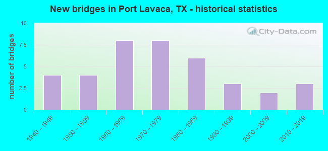
- New bridges - historical statistics
- 41940-1949
- 41950-1959
- 81960-1969
- 81970-1979
- 61980-1989
- 31990-1999
- 22000-2009
- 32010-2019

- Reconstructed bridges - Historical Statistics
- 11970-1979
- 01980-1989
- 31990-1999
- 32000-2009


- Bridge Condition - Deck
- 9.1%Very good
- 63.6%Good
- 27.3%Satisfactory

- Bridge Condition - Superstructure
- 72.7%Good
- 27.3%Satisfactory

- Bridge Condition - Substructure
- 54.5%Good
- 27.3%Satisfactory
- 18.2%Fair

- Bridge Condition - Channel
- 47.4%Good
- 50.0%Satisfactory
- 2.6%Fair

- Bridge Condition - Culverts
- 77.8%Good
- 22.2%Satisfactory
Find on map >> Show street view
Structure Number: 130290014403029, Location: 2.75 MI W OF SH 35 (Lat: 28.614464, Lng: -96.692972), Route carried "on" structure: US 87, Year Built: 1942, Year Reconstructed: 2006, Status: Open, Structure Length: 1.16m (3.81ft), Average Daily Traffic: 7,675 (year 2020), Truck Traffic: 5%, Average Future Daily Traffic: 8,170 (year 2033), Design Load: H 15, Features Intersected: DRAINAGE DITCH
Minimum Vertical Clearance: 30+ m (98+ ft), Kilometerpoint: 9.395, Lanes on structure: 4, Owner: State Highway Agency, Approaching Roadway Width: 24.4m (80.1ft), Skew: 14 degrees, Material/Design: Concrete, Design/Construction: Culvert, Number Of Spans In Main Unit: 4, Length of Maximum Span: 1.8m (5.9ft), Curb-To-Curb Width: 24.4m (80.1ft), Out-to-Out Width: 46.6m (152.9ft)
Condition: Channel: Good, Culverts: Good, Operating Rating: 39.9 metric tons, Method Used To Determine Operating Rating: Load Factor (LF), Inventory Rating: 23.6 metric tons, Method Used To Determine Inventory Rating: Load Factor (LF), Structural Evaluation: Somewhat better than minimum adequacy, Deck Geometry: Superior to present desirable criteria, Waterway Adequacy: Equal to present minimum criteria, Approach Roadway Alignment: Equal to present desirable criteria, Designated Inspection Frequency: Every 24 months, Inspection Date: December 2020, Deck Structure Type: Concrete Cast-file-Place, Wearing Surface/Protective System: Wearing Surface: Bituminous
Find on map >> Show street view
Structure Number: 13029001440303, Location: 1.75 MI W OF SH 35 (Lat: 28.612783, Lng: -96.674597), Route carried "on" structure: US 87, Year Built: 1942, Year Reconstructed: 1999, Status: Open, Structure Length: 1.13m (3.71ft), Average Daily Traffic: 7,675 (year 2020), Truck Traffic: 5%, Average Future Daily Traffic: 8,170 (year 2033), Design Load: H 15, Features Intersected: DRAINAGE DITCH
Minimum Vertical Clearance: 30+ m (98+ ft), Kilometerpoint: 11.206, Lanes on structure: 5, Owner: State Highway Agency, Approaching Roadway Width: 25.8m (84.6ft), Skew: 9 degrees, Material/Design: Concrete, Design/Construction: Culvert, Number Of Spans In Main Unit: 4, Length of Maximum Span: 1.8m (5.9ft), Curb-To-Curb Width: 26.1m (85.6ft), Out-to-Out Width: 32.3m (106.0ft)
Condition: Channel: Good, Culverts: Satisfactory, Operating Rating: 39.9 metric tons, Method Used To Determine Operating Rating: Load Factor (LF), Inventory Rating: 23.6 metric tons, Method Used To Determine Inventory Rating: Load Factor (LF), Structural Evaluation: Somewhat better than minimum adequacy, Deck Geometry: Superior to present desirable criteria, Waterway Adequacy: Equal to present minimum criteria, Approach Roadway Alignment: Equal to present desirable criteria, Designated Inspection Frequency: Every 24 months, Inspection Date: December 2020, Deck Structure Type: Concrete Cast-file-Place, Wearing Surface/Protective System: Wearing Surface: Bituminous
Find on map >> Show street view
Structure Number: 130290014403031, Location: 1.1 MI W OF SH 35 (Lat: 28.611600, Lng: -96.665625), Route carried "on" structure: US 87, Year Built: 1942, Year Reconstructed: 1999, Status: Open, Structure Length: 1.34m (4.40ft), Average Daily Traffic: 11,859 (year 2020), Truck Traffic: 5%, Average Future Daily Traffic: 13,430 (year 2033), Design Load: H 15, Features Intersected: LITTLE CHOCOLATE BYU
Minimum Vertical Clearance: 30+ m (98+ ft), Kilometerpoint: 12.062, Lanes on structure: 5, Owner: State Highway Agency, Approaching Roadway Width: 25.0m (82.0ft), Material/Design: Concrete, Design/Construction: Culvert, Number Of Spans In Main Unit: 5, Length of Maximum Span: 2.4m (7.9ft), Curb-To-Curb Width: 24.9m (81.7ft), Out-to-Out Width: 26.9m (88.3ft)
Condition: Channel: Satisfactory, Culverts: Good, Operating Rating: 39.9 metric tons, Method Used To Determine Operating Rating: Load Factor (LF), Inventory Rating: 23.6 metric tons, Method Used To Determine Inventory Rating: Load Factor (LF), Structural Evaluation: Somewhat better than minimum adequacy, Deck Geometry: Superior to present desirable criteria, Waterway Adequacy: Equal to present minimum criteria, Approach Roadway Alignment: Equal to present desirable criteria, Designated Inspection Frequency: Every 24 months, Inspection Date: December 2020, Deck Structure Type: Concrete Cast-file-Place, Wearing Surface/Protective System: Wearing Surface: Bituminous
Find on map >> Show street view
Structure Number: 130290014403048, Location: 0.3 MI W OF SH 35 (Lat: 28.610619, Lng: -96.650253), Route carried "on" structure: US 87, Year Built: 1967, Year Reconstructed: 2000, Status: Open, Structure Length: 0.70m (2.30ft), Average Daily Traffic: 11,859 (year 2020), Truck Traffic: 5%, Average Future Daily Traffic: 5,400 (year 2033), Features Intersected: BLARDONE DITCH
Minimum Vertical Clearance: 30+ m (98+ ft), Kilometerpoint: 15.162, Lanes on structure: 5, Owner: State Highway Agency, Approaching Roadway Width: 25.0m (82.0ft), Skew: 4 degrees, Material/Design: Concrete, Design/Construction: Culvert, Number Of Spans In Main Unit: 3, Length of Maximum Span: 1.5m (4.9ft), Curb-To-Curb Width: 25.2m (82.7ft), Out-to-Out Width: 26.4m (86.6ft)
Condition: Channel: Good, Culverts: Good, Operating Rating: 32.7 metric tons, Method Used To Determine Operating Rating: Field evaluation and documented engineering judgment, Inventory Rating: 24.5 metric tons, Method Used To Determine Inventory Rating: Field evaluation and documented engineering judgment, Structural Evaluation: Equal to present minimum criteria, Deck Geometry: Superior to present desirable criteria, Waterway Adequacy: Equal to present minimum criteria, Approach Roadway Alignment: Equal to present desirable criteria, Designated Inspection Frequency: Every 24 months, Inspection Date: December 2020, Deck Structure Type: Concrete Cast-file-Place, Wearing Surface/Protective System: Wearing Surface: Bituminous
Find on map >> Show street view
Structure Number: 130290014404046, Location: 0.33 MI S OF FM 1090 (Lat: 28.596481, Lng: -96.640619), Route carried "on" structure: State highway 238, Year Built: 1966, Status: Open, Structure Length: 0.88m (2.89ft), Average Daily Traffic: 5,705 (year 2020), Truck Traffic: 12%, Average Future Daily Traffic: 5,550 (year 2033), Features Intersected: DRAW
Minimum Vertical Clearance: 30+ m (98+ ft), Kilometerpoint: 6.367, Lanes on structure: 4, Owner: State Highway Agency, Approaching Roadway Width: 19.2m (63.0ft), Material/Design: Concrete, Design/Construction: Culvert, Number Of Spans In Main Unit: 3, Length of Maximum Span: 2.7m (8.9ft), Curb or Sidewalk Widths: Left: 1.7m (5.6ft), Right: 1.7m (5.6ft)
Condition: Channel: Satisfactory, Culverts: Satisfactory, Operating Rating: 32.7 metric tons, Method Used To Determine Operating Rating: Field evaluation and documented engineering judgment, Inventory Rating: 24.5 metric tons, Method Used To Determine Inventory Rating: Field evaluation and documented engineering judgment, Structural Evaluation: Equal to present minimum criteria, Waterway Adequacy: Equal to present minimum criteria, Approach Roadway Alignment: Equal to present desirable criteria, Designated Inspection Frequency: Every 24 months, Inspection Date: December 2020
Find on map >> Show street view
Structure Number: 130290014404047, Location: 0.80 MI E OF FM 2433 (Lat: 28.591794, Lng: -96.644600), Route carried "on" structure: State highway 238, Year Built: 1966, Status: Open, Structure Length: 4.63m (15.19ft), Average Daily Traffic: 4,213 (year 2020), Truck Traffic: 12%, Average Future Daily Traffic: 5,700 (year 2033), Design Load: H 20, Features Intersected: LITTLE CHOCOLATE BYU
Minimum Vertical Clearance: 30+ m (98+ ft), Kilometerpoint: 6.997, Lanes on structure: 4, Owner: State Highway Agency, Approaching Roadway Width: 19.2m (63.0ft), Material/Design: Concrete, Design/Construction: Stringer/Multi-beam, Number Of Spans In Main Unit: 5, Length of Maximum Span: 9.1m (29.9ft), Curb or Sidewalk Widths: Left: 1.5m (4.9ft), Right: 1.5m (4.9ft), Curb-To-Curb Width: 19.1m (62.7ft), Out-to-Out Width: 22.9m (75.1ft)
Condition: Deck: Satisfactory, Superstructure: Good, Substructure: Satisfactory, Channel: Satisfactory, Operating Rating: 54.4 metric tons, Method Used To Determine Operating Rating: Load Factor (LF), Inventory Rating: 32.7 metric tons, Method Used To Determine Inventory Rating: Load Factor (LF), Structural Evaluation: Equal to present minimum criteria, Deck Geometry: Equal to present minimum criteria, Waterway Adequacy: Equal to present minimum criteria, Approach Roadway Alignment: Equal to present desirable criteria, Designated Inspection Frequency: Every 24 months, Inspection Date: December 2020, Deck Structure Type: Concrete Cast-file-Place, Wearing Surface/Protective System: Wearing Surface: Bituminous
Find on map >> Show street view
Structure Number: 130290014404049, Location: 0.03 MI S OF FM 2541 (Lat: 28.569772, Lng: -96.638211), Route carried "on" structure: State highway 238, Year Built: 1971, Status: Open, Structure Length: 0.91m (2.99ft), Average Daily Traffic: 5,593 (year 2020), Truck Traffic: 11%, Average Future Daily Traffic: 6,040 (year 2033), Design Load: H 20, Features Intersected: DRAW
Minimum Vertical Clearance: 30+ m (98+ ft), Kilometerpoint: 10.395, Lanes on structure: 2, Owner: State Highway Agency, Approaching Roadway Width: 13.7m (44.9ft), Material/Design: Concrete, Design/Construction: Culvert, Number Of Spans In Main Unit: 4, Length of Maximum Span: 2.1m (6.9ft)
Condition: Channel: Satisfactory, Culverts: Good, Operating Rating: 39.9 metric tons, Method Used To Determine Operating Rating: Load Factor (LF), Inventory Rating: 23.6 metric tons, Method Used To Determine Inventory Rating: Load Factor (LF), Structural Evaluation: Somewhat better than minimum adequacy, Waterway Adequacy: Equal to present minimum criteria, Approach Roadway Alignment: Equal to present desirable criteria, Designated Inspection Frequency: Every 24 months, Inspection Date: December 2020
Find on map >> Show street view
Structure Number: 13029001440405, Location: 0.43 MI S OF FM 2433 (Lat: 28.577414, Lng: -96.649603), Route carried "on" structure: State highway 238, Year Built: 1971, Status: Open, Structure Length: 21.34m (70.01ft), Average Daily Traffic: 5,707 (year 2020), Truck Traffic: 8%, Average Future Daily Traffic: 9,350 (year 2033), Design Load: HS 20, Features Intersected: BIG CHOCOLATE BAYOU
Minimum Vertical Clearance: 30+ m (98+ ft), Kilometerpoint: 8.969, Lanes on structure: 2, Owner: State Highway Agency, Approaching Roadway Width: 14.0m (45.9ft), Material/Design: Prestressed concrete, Design/Construction: Stringer/Multi-beam, Number Of Spans In Main Unit: 10, Length of Maximum Span: 21.3m (69.9ft), Curb-To-Curb Width: 14.7m (48.2ft), Out-to-Out Width: 15.3m (50.2ft)
Condition: Deck: Good, Superstructure: Good, Substructure: Satisfactory, Channel: Fair, Operating Rating: 54.4 metric tons, Method Used To Determine Operating Rating: Assigned rating based on Load Factor Design (LFD) reported in metric tons, Inventory Rating: 32.7 metric tons, Method Used To Determine Inventory Rating: Assigned rating based on Load Factor Design (LFD) reported in metric tons, Structural Evaluation: Equal to present minimum criteria, Deck Geometry: Superior to present desirable criteria, Waterway Adequacy: Superior to present desirable criteria, Approach Roadway Alignment: Equal to present desirable criteria, Designated Inspection Frequency: Every 24 months, Underwater Inspection Frequency: Every 60 months, Inspection Date: December 2020, Underwater Inspection Date: Febuary 2020, Deck Structure Type: Concrete Cast-file-Place, Wearing Surface/Protective System: Wearing Surface: Bituminous
Find on map >> Show street view
Structure Number: 130290014404051, Location: AT JCT OF SH 238 & SH 316 (Lat: 28.566650, Lng: -96.633722), Route carried "on" structure: State highway 238, Year Built: 1971, Status: Open, Structure Length: 0.67m (2.20ft), Average Daily Traffic: 5,593 (year 2020), Truck Traffic: 11%, Average Future Daily Traffic: 6,040 (year 2033), Design Load: H 20, Features Intersected: DRAINAGE D
Minimum Vertical Clearance: 30+ m (98+ ft), Kilometerpoint: 10.961, Lanes on structure: 3, Owner: State Highway Agency, Approaching Roadway Width: 18.3m (60.0ft), Material/Design: Concrete, Design/Construction: Culvert, Number Of Spans In Main Unit: 3, Length of Maximum Span: 2.1m (6.9ft)
Condition: Channel: Satisfactory, Culverts: Good, Operating Rating: 39.9 metric tons, Method Used To Determine Operating Rating: Load Factor (LF), Inventory Rating: 23.6 metric tons, Method Used To Determine Inventory Rating: Load Factor (LF), Structural Evaluation: Somewhat better than minimum adequacy, Waterway Adequacy: Equal to present minimum criteria, Approach Roadway Alignment: Equal to present desirable criteria, Designated Inspection Frequency: Every 24 months, Inspection Date: December 2020
Find on map >> Show street view
Structure Number: 130290014405041, Location: 0.70 MI S OF SH 316 (Lat: 28.557022, Lng: -96.635444), Route carried "on" structure: State highway 238, Year Built: 1949, Year Reconstructed: 1998, Status: Open, Structure Length: 0.88m (2.89ft), Average Daily Traffic: 3,300 (year 2020), Truck Traffic: 14%, Average Future Daily Traffic: 3,490 (year 2033), Features Intersected: DRAINAGE DITCH
Minimum Vertical Clearance: 30+ m (98+ ft), Kilometerpoint: 8.736, Lanes on structure: 2, Owner: State Highway Agency, Approaching Roadway Width: 11.9m (39.0ft), Skew: 4 degrees, Material/Design: Concrete, Design/Construction: Culvert, Number Of Spans In Main Unit: 3, Length of Maximum Span: 1.8m (5.9ft)
Condition: Channel: Good, Culverts: Good, Operating Rating: 39.9 metric tons, Method Used To Determine Operating Rating: Load Factor (LF), Inventory Rating: 23.6 metric tons, Method Used To Determine Inventory Rating: Load Factor (LF), Structural Evaluation: Equal to present minimum criteria, Waterway Adequacy: Equal to present minimum criteria, Approach Roadway Alignment: Equal to present desirable criteria, Designated Inspection Frequency: Every 24 months, Inspection Date: December 2020
Find on map >> Show street view
Structure Number: 130290017910061, Location: AT PORT LAVACA N.C.L. (Lat: 28.643650, Lng: -96.607106), Route carried "on" structure: State highway 35, Year Built: 1961, Status: Open, Structure Length: 362.77m (1190.19ft), Average Daily Traffic: 17,189 (year 2020), Truck Traffic: 13%, Average Future Daily Traffic: 14,350 (year 2033), Features Intersected: LAVACA BAY
Minimum Vertical Clearance: 30+ m (98+ ft), Kilometerpoint: 10.429, Lanes on structure: 4, Owner: State Highway Agency, Approaching Roadway Width: 22.6m (74.1ft), Skew: 20 degrees, Navigation Control: Yes ( Vertical Clearance: 13.7m (44.9ft), Horizontal Clearance: 22.9m (75.1ft)), Material/Design: Steel continuous, Design/Construction: Stringer/Multi-beam, Number Of Spans In Main Unit: 3, Number Of Approach Spans: 194, Length of Maximum Span: 30.5m (100.1ft), Curb or Sidewalk Widths: Left: 0.6m (2.0ft), Right: 0.6m (2.0ft), Curb-To-Curb Width: 15.7m (51.5ft), Out-to-Out Width: 19.3m (63.3ft)
Condition: Deck: Satisfactory, Superstructure: Satisfactory, Substructure: Fair, Channel: Good, Operating Rating: 43.5 metric tons, Method Used To Determine Operating Rating: Load Factor (LF), Inventory Rating: 28.1 metric tons, Method Used To Determine Inventory Rating: Load Factor (LF), Structural Evaluation: Somewhat better than minimum adequacy, Deck Geometry: Meets minimum limits, Waterway Adequacy: Equal to present minimum criteria, Approach Roadway Alignment: Equal to present desirable criteria, Length Of Structure Improvement: 362.77m (1190.19ft), Designated Inspection Frequency: Every 24 months, Underwater Inspection Frequency: Every 60 months, Inspection Date: December 2020, Underwater Inspection Date: January 2018, Bridge Improvement Cost: $1,095,000, Roadway Improvement Cost: $274,000, Total Project Cost: $1,369,000, Deck Structure Type: Concrete Cast-file-Place
Find on map >> Show street view
Structure Number: 130290017910071, Location: 0.35 MI S OF FM 1090 (Lat: 28.620922, Lng: -96.638764), Route carried "on" structure: State highway 35, Year Built: 1982, Status: Open, Structure Length: 1.13m (3.71ft), Average Daily Traffic: 7,190 (year 2013), Truck Traffic: 13%, Average Future Daily Traffic: 10,070 (year 2033), Design Load: HS 20, Features Intersected: BARTON DITCH
Minimum Vertical Clearance: 30+ m (98+ ft), Kilometerpoint: 17.510, Lanes on structure: 2, Owner: State Highway Agency, Approaching Roadway Width: 11.6m (38.1ft), Skew: 4 degrees, Material/Design: Concrete, Design/Construction: Culvert, Number Of Spans In Main Unit: 3, Length of Maximum Span: 2.4m (7.9ft), Curb or Sidewalk Widths: Left: 0.0m, Right: 1.8m (5.9ft), Curb-To-Curb Width: 11.7m (38.4ft), Out-to-Out Width: 14.4m (47.2ft)
Condition: Channel: Good, Culverts: Good, Operating Rating: 39.9 metric tons, Method Used To Determine Operating Rating: Load Factor (LF), Inventory Rating: 23.6 metric tons, Method Used To Determine Inventory Rating: Load Factor (LF), Structural Evaluation: Somewhat better than minimum adequacy, Deck Geometry: Better than present minimum criteria, Waterway Adequacy: Equal to present minimum criteria, Approach Roadway Alignment: Equal to present desirable criteria, Designated Inspection Frequency: Every 48 months, Inspection Date: December 2020, Deck Structure Type: Concrete Cast-file-Place, Wearing Surface/Protective System: Wearing Surface: Bituminous
Find on map >> Show street view
Structure Number: 130290017910072, Location: 0.35 MI S OF FM 1090 (Lat: 28.620875, Lng: -96.638556), Route carried "on" structure: State highway 35, Year Built: 1982, Status: Open, Structure Length: 1.13m (3.71ft), Average Daily Traffic: 8,170 (year 2013), Truck Traffic: 13%, Average Future Daily Traffic: 11,440 (year 2033), Design Load: HS 20, Features Intersected: BARTON DITCH
Minimum Vertical Clearance: 30+ m (98+ ft), Kilometerpoint: 17.550, Lanes on structure: 2, Owner: State Highway Agency, Approaching Roadway Width: 11.6m (38.1ft), Skew: 4 degrees, Material/Design: Concrete, Design/Construction: Culvert, Number Of Spans In Main Unit: 3, Length of Maximum Span: 2.4m (7.9ft), Curb or Sidewalk Widths: Left: 0.0m, Right: 1.8m (5.9ft), Curb-To-Curb Width: 11.7m (38.4ft), Out-to-Out Width: 14.4m (47.2ft)
Condition: Channel: Good, Culverts: Good, Operating Rating: 39.9 metric tons, Method Used To Determine Operating Rating: Load Factor (LF), Inventory Rating: 23.6 metric tons, Method Used To Determine Inventory Rating: Load Factor (LF), Structural Evaluation: Somewhat better than minimum adequacy, Deck Geometry: Better than present minimum criteria, Waterway Adequacy: Equal to present minimum criteria, Approach Roadway Alignment: Equal to present desirable criteria, Designated Inspection Frequency: Every 48 months, Inspection Date: December 2020, Deck Structure Type: Concrete Cast-file-Place, Wearing Surface/Protective System: Wearing Surface: Bituminous
Find on map >> Show street view
Structure Number: 130290017910073, Location: 1.06 MI S OF SH 238 (Lat: 28.629614, Lng: -96.633636), Route carried "on" structure: State highway 35, Year Built: 1982, Status: Open, Structure Length: 2.87m (9.42ft), Average Daily Traffic: 8,030 (year 2013), Truck Traffic: 13%, Average Future Daily Traffic: 11,240 (year 2033), Design Load: HS 20, Features Intersected: LYNN BAYOU
Minimum Vertical Clearance: 30+ m (98+ ft), Kilometerpoint: 16.447, Lanes on structure: 2, Owner: State Highway Agency, Approaching Roadway Width: 11.6m (38.1ft), Skew: 1 degrees, Material/Design: Concrete, Design/Construction: Stringer/Multi-beam, Number Of Spans In Main Unit: 3, Length of Maximum Span: 9.4m (30.8ft), Curb or Sidewalk Widths: Left: 1.3m (4.3ft), Right: 0.0m, Curb-To-Curb Width: 11.6m (38.1ft), Out-to-Out Width: 13.4m (44.0ft)
Condition: Deck: Good, Superstructure: Good, Substructure: Good, Channel: Satisfactory, Operating Rating: 68.0 metric tons, Method Used To Determine Operating Rating: Load Factor (LF), Inventory Rating: 40.8 metric tons, Method Used To Determine Inventory Rating: Load Factor (LF), Structural Evaluation: Better than present minimum criteria, Deck Geometry: Better than present minimum criteria, Waterway Adequacy: Superior to present desirable criteria, Approach Roadway Alignment: Equal to present desirable criteria, Length Of Structure Improvement: 2.87m (9.42ft), Designated Inspection Frequency: Every 24 months, Inspection Date: December 2020, Deck Structure Type: Concrete Cast-file-Place, Wearing Surface/Protective System: Wearing Surface: Bituminous
Find on map >> Show street view
Structure Number: 130290017910074, Location: 1.06 MI S OF SH 238 (Lat: 28.629367, Lng: -96.633281), Route carried "on" structure: State highway 35, Year Built: 1982, Status: Open, Structure Length: 2.87m (9.42ft), Average Daily Traffic: 8,030 (year 2013), Truck Traffic: 13%, Average Future Daily Traffic: 11,240 (year 2033), Design Load: HS 20, Features Intersected: LYNN BAYOU
Minimum Vertical Clearance: 30+ m (98+ ft), Kilometerpoint: 16.460, Lanes on structure: 2, Owner: State Highway Agency, Approaching Roadway Width: 11.6m (38.1ft), Skew: 1 degrees, Material/Design: Concrete, Design/Construction: Stringer/Multi-beam, Number Of Spans In Main Unit: 3, Length of Maximum Span: 9.4m (30.8ft), Curb or Sidewalk Widths: Left: 0.0m, Right: 1.3m (4.3ft), Curb-To-Curb Width: 11.6m (38.1ft), Out-to-Out Width: 13.4m (44.0ft)
Condition: Deck: Good, Superstructure: Good, Substructure: Good, Channel: Satisfactory, Operating Rating: 68.0 metric tons, Method Used To Determine Operating Rating: Load Factor (LF), Inventory Rating: 40.8 metric tons, Method Used To Determine Inventory Rating: Load Factor (LF), Structural Evaluation: Better than present minimum criteria, Deck Geometry: Better than present minimum criteria, Waterway Adequacy: Superior to present desirable criteria, Approach Roadway Alignment: Equal to present desirable criteria, Designated Inspection Frequency: Every 24 months, Inspection Date: December 2020, Deck Structure Type: Concrete Cast-file-Place, Wearing Surface/Protective System: Wearing Surface: Bituminous
Find on map >> Show street view
Structure Number: 130290017915076, Location: 1.02 MI S OF SH 35 (Lat: 28.623783, Lng: -96.625681), Route carried "on" structure: State highway 238, Year Built: 1988, Status: Open, Structure Length: 2.77m (9.09ft), Average Daily Traffic: 7,037 (year 2020), Truck Traffic: 11%, Average Future Daily Traffic: 8,410 (year 2033), Design Load: HS 20, Features Intersected: Lynn Bayou
Minimum Vertical Clearance: 30+ m (98+ ft), Kilometerpoint: 2.511, Lanes on structure: 5, Owner: State Highway Agency, Approaching Roadway Width: 18.9m (62.0ft), Material/Design: Concrete, Design/Construction: Stringer/Multi-beam, Number Of Spans In Main Unit: 3, Length of Maximum Span: 9.1m (29.9ft), Curb or Sidewalk Widths: Left: 1.6m (5.2ft), Right: 1.6m (5.2ft), Curb-To-Curb Width: 19.2m (63.0ft), Out-to-Out Width: 23.3m (76.4ft)
Condition: Deck: Good, Superstructure: Good, Substructure: Good, Channel: Satisfactory, Operating Rating: 68.0 metric tons, Method Used To Determine Operating Rating: Load Factor (LF), Inventory Rating: 40.8 metric tons, Method Used To Determine Inventory Rating: Load Factor (LF), Structural Evaluation: Better than present minimum criteria, Deck Geometry: Meets minimum limits, Waterway Adequacy: Superior to present desirable criteria, Approach Roadway Alignment: Equal to present desirable criteria, Designated Inspection Frequency: Every 24 months, Underwater Inspection Frequency: Every 60 months, Inspection Date: December 2020, Underwater Inspection Date: April 2017, Deck Structure Type: Concrete Cast-file-Place, Wearing Surface/Protective System: Wearing Surface: Bituminous
Find on map >> Show street view
Structure Number: 130290018001032, Location: 1.85 MI SW OF FM 2433 (Lat: 28.578111, Lng: -96.700397), Route carried "on" structure: State highway 35, Year Built: 1958, Status: Open, Structure Length: 10.18m (33.40ft), Average Daily Traffic: 7,536 (year 2020), Truck Traffic: 13%, Average Future Daily Traffic: 9,540 (year 2033), Features Intersected: BIG CHOCOLATE BYU
Minimum Vertical Clearance: 30+ m (98+ ft), Kilometerpoint: 6.705, Lanes on structure: 2, Owner: State Highway Agency, Approaching Roadway Width: 13.1m (43.0ft), Material/Design: Concrete, Design/Construction: Stringer/Multi-beam, Number Of Spans In Main Unit: 11, Length of Maximum Span: 9.1m (29.9ft), Curb-To-Curb Width: 13.1m (43.0ft), Out-to-Out Width: 13.9m (45.6ft)
Condition: Deck: Good, Superstructure: Satisfactory, Substructure: Fair, Channel: Satisfactory, Operating Rating: 68.0 metric tons, Method Used To Determine Operating Rating: Load Factor (LF), Inventory Rating: 40.8 metric tons, Method Used To Determine Inventory Rating: Load Factor (LF), Structural Evaluation: Somewhat better than minimum adequacy, Deck Geometry: Somewhat better than minimum adequacy, Waterway Adequacy: Superior to present desirable criteria, Approach Roadway Alignment: Equal to present desirable criteria, Designated Inspection Frequency: Every 24 months, Inspection Date: December 2020, Deck Structure Type: Concrete Cast-file-Place, Wearing Surface/Protective System: Wearing Surface: Bituminous
Find on map >> Show street view
Structure Number: 130290018001033, Location: 1.30 MI NE OF FM 2433 (Lat: 28.603972, Lng: -96.656903), Route carried "on" structure: State highway 35, Year Built: 1958, Status: Open, Structure Length: 4.63m (15.19ft), Average Daily Traffic: 8,519 (year 2020), Truck Traffic: 12%, Average Future Daily Traffic: 6,990 (year 2033), Features Intersected: LITTLE CHOCOLATE BYU
Minimum Vertical Clearance: 30+ m (98+ ft), Kilometerpoint: 1.613, Lanes on structure: 2, Owner: State Highway Agency, Approaching Roadway Width: 13.4m (44.0ft), Material/Design: Concrete, Design/Construction: Stringer/Multi-beam, Number Of Spans In Main Unit: 5, Length of Maximum Span: 9.1m (29.9ft), Curb-To-Curb Width: 13.2m (43.3ft), Out-to-Out Width: 13.9m (45.6ft)
Condition: Deck: Good, Superstructure: Good, Substructure: Good, Channel: Good, Operating Rating: 68.0 metric tons, Method Used To Determine Operating Rating: Load Factor (LF), Inventory Rating: 40.8 metric tons, Method Used To Determine Inventory Rating: Load Factor (LF), Structural Evaluation: Better than present minimum criteria, Deck Geometry: Somewhat better than minimum adequacy, Waterway Adequacy: Equal to present minimum criteria, Approach Roadway Alignment: Equal to present desirable criteria, Designated Inspection Frequency: Every 24 months, Inspection Date: December 2020, Deck Structure Type: Concrete Cast-file-Place, Wearing Surface/Protective System: Wearing Surface: Bituminous
Find on map >> Show street view
Structure Number: 130290018001065, Location: 1.89 MI SW OF FM 2433 (Lat: 28.577625, Lng: -96.701078), Route carried "on" structure: State highway 35, Year Built: 1998, Status: Open, Structure Length: 1.43m (4.69ft), Average Daily Traffic: 6,370 (year 2020), Truck Traffic: 13%, Average Future Daily Traffic: 9,540 (year 2033), Design Load: HS 20, Features Intersected: BIG CHOCOLATE BAYOU REL
Minimum Vertical Clearance: 30+ m (98+ ft), Kilometerpoint: 6.677, Lanes on structure: 2, Owner: State Highway Agency, Approaching Roadway Width: 13.1m (43.0ft), Material/Design: Concrete, Design/Construction: Culvert, Number Of Spans In Main Unit: 4, Length of Maximum Span: 3.0m (9.8ft), Curb-To-Curb Width: 13.3m (43.6ft), Out-to-Out Width: 14.0m (45.9ft)
Condition: Channel: Good, Culverts: Satisfactory, Operating Rating: 39.9 metric tons, Method Used To Determine Operating Rating: Load Factor (LF), Inventory Rating: 23.6 metric tons, Method Used To Determine Inventory Rating: Load Factor (LF), Structural Evaluation: Somewhat better than minimum adequacy, Deck Geometry: Somewhat better than minimum adequacy, Waterway Adequacy: Superior to present desirable criteria, Approach Roadway Alignment: Equal to present desirable criteria, Designated Inspection Frequency: Every 48 months, Inspection Date: December 2018, Deck Structure Type: Concrete Cast-file-Place, Wearing Surface/Protective System: Wearing Surface: Bituminous
Find on map >> Show street view
Structure Number: 130290051503012, Location: 1.28 MI S OF VICTORIA C/L (Lat: 28.675569, Lng: -96.677178), Route carried "on" structure: State highway 1090, Year Built: 1960, Status: Open, Structure Length: 1.31m (4.30ft), Average Daily Traffic: 2,651 (year 2020), Truck Traffic: 12%, Average Future Daily Traffic: 3,890 (year 2033), Features Intersected: SIX MILE CREEK
Minimum Vertical Clearance: 30+ m (98+ ft), Kilometerpoint: 2.037, Lanes on structure: 2, Owner: State Highway Agency, Approaching Roadway Width: 6.7m (22.0ft), Material/Design: Concrete, Design/Construction: Culvert, Number Of Spans In Main Unit: 4, Length of Maximum Span: 3.0m (9.8ft), Curb-To-Curb Width: 9.8m (32.2ft), Out-to-Out Width: 10.2m (33.5ft)
Condition: Channel: Good, Culverts: Good, Operating Rating: 39.9 metric tons, Method Used To Determine Operating Rating: Load Factor (LF), Inventory Rating: 23.6 metric tons, Method Used To Determine Inventory Rating: Load Factor (LF), Structural Evaluation: Equal to present minimum criteria, Deck Geometry: Meets minimum limits, Waterway Adequacy: Equal to present minimum criteria, Approach Roadway Alignment: Equal to present desirable criteria, Designated Inspection Frequency: Every 24 months, Inspection Date: December 2020, Deck Structure Type: Concrete Cast-file-Place, Wearing Surface/Protective System: Wearing Surface: Bituminous
Find on map >> Show street view
Structure Number: 130290051503013, Location: 0.23 MI S OF SH 35 (Lat: 28.623347, Lng: -96.633753), Route carried "on" structure: State highway 1090, Year Built: 1960, Status: Open, Structure Length: 0.70m (2.30ft), Average Daily Traffic: 8,781 (year 2020), Truck Traffic: 4%, Average Future Daily Traffic: 10,820 (year 2033), Features Intersected: BARTON DITCH
Minimum Vertical Clearance: 30+ m (98+ ft), Kilometerpoint: 9.278, Lanes on structure: 4, Owner: State Highway Agency, Approaching Roadway Width: 18.9m (62.0ft), Skew: 1 degrees, Material/Design: Concrete, Design/Construction: Culvert, Number Of Spans In Main Unit: 2, Length of Maximum Span: 3.0m (9.8ft), Curb or Sidewalk Widths: Left: 1.2m (3.9ft), Right: 1.2m (3.9ft), Curb-To-Curb Width: 18.9m (62.0ft), Out-to-Out Width: 21.9m (71.9ft)
Condition: Channel: Satisfactory, Culverts: Good, Operating Rating: 39.9 metric tons, Method Used To Determine Operating Rating: Load Factor (LF), Inventory Rating: 23.6 metric tons, Method Used To Determine Inventory Rating: Load Factor (LF), Structural Evaluation: Somewhat better than minimum adequacy, Deck Geometry: Equal to present minimum criteria, Waterway Adequacy: Equal to present minimum criteria, Approach Roadway Alignment: Equal to present desirable criteria, Designated Inspection Frequency: Every 24 months, Inspection Date: December 2020, Deck Structure Type: Concrete Cast-file-Place, Wearing Surface/Protective System: Wearing Surface: Bituminous
Find on map >> Show street view
Structure Number: 130290051503022, Location: 2.15 MI S OF FM 3084 (Lat: 28.631589, Lng: -96.640594), Route carried "on" structure: State highway 1090, Year Built: 1971, Status: Open, Structure Length: 0.70m (2.30ft), Average Daily Traffic: 6,443 (year 2020), Truck Traffic: 4%, Average Future Daily Traffic: 8,700 (year 2033), Features Intersected: DRAW
Minimum Vertical Clearance: 30+ m (98+ ft), Kilometerpoint: 8.122, Lanes on structure: 4, Owner: State Highway Agency, Approaching Roadway Width: 15.9m (52.2ft), Material/Design: Concrete, Design/Construction: Culvert, Number Of Spans In Main Unit: 3, Length of Maximum Span: 2.1m (6.9ft), Curb-To-Curb Width: 15.9m (52.2ft), Out-to-Out Width: 23.2m (76.1ft)
Condition: Channel: Satisfactory, Culverts: Good, Operating Rating: 32.7 metric tons, Method Used To Determine Operating Rating: Field evaluation and documented engineering judgment, Inventory Rating: 24.5 metric tons, Method Used To Determine Inventory Rating: Field evaluation and documented engineering judgment, Structural Evaluation: Equal to present minimum criteria, Deck Geometry: Meets minimum limits, Waterway Adequacy: Superior to present desirable criteria, Approach Roadway Alignment: Equal to present desirable criteria, Designated Inspection Frequency: Every 24 months, Inspection Date: December 2020, Deck Structure Type: Concrete Cast-file-Place, Wearing Surface/Protective System: Wearing Surface: Bituminous
Find on map >> Show street view
Structure Number: 130290058001011, Location: 0.53 MI E OF SH 238 (Lat: 28.561997, Lng: -96.625908), Route carried "on" structure: State highway 316, Year Built: 1971, Status: Open, Structure Length: 0.91m (2.99ft), Average Daily Traffic: 2,028 (year 2020), Truck Traffic: 19%, Average Future Daily Traffic: 2,000 (year 2033), Design Load: H 20, Features Intersected: DRAW
Minimum Vertical Clearance: 30+ m (98+ ft), Kilometerpoint: 0.999, Lanes on structure: 2, Owner: State Highway Agency, Approaching Roadway Width: 12.8m (42.0ft), Material/Design: Concrete, Design/Construction: Culvert, Number Of Spans In Main Unit: 4, Length of Maximum Span: 2.1m (6.9ft), Curb-To-Curb Width: 26.2m (86.0ft), Out-to-Out Width: 26.6m (87.3ft)
Condition: Channel: Good, Culverts: Good, Operating Rating: 39.9 metric tons, Method Used To Determine Operating Rating: Load Factor (LF), Inventory Rating: 23.6 metric tons, Method Used To Determine Inventory Rating: Load Factor (LF), Structural Evaluation: Equal to present minimum criteria, Deck Geometry: Superior to present desirable criteria, Waterway Adequacy: Equal to present minimum criteria, Approach Roadway Alignment: Equal to present desirable criteria, Designated Inspection Frequency: Every 24 months, Inspection Date: December 2020, Deck Structure Type: Concrete Cast-file-Place, Wearing Surface/Protective System: Wearing Surface: Bituminous
Find on map >> Show street view
Structure Number: 130290058001012, Location: 2.02 MI E OF SH 238 (Lat: 28.549339, Lng: -96.606194), Route carried "on" structure: State highway 316, Year Built: 1971, Status: Open, Structure Length: 1.16m (3.81ft), Average Daily Traffic: 2,028 (year 2020), Truck Traffic: 19%, Average Future Daily Traffic: 2,000 (year 2033), Design Load: H 20, Features Intersected: DRAW
Minimum Vertical Clearance: 30+ m (98+ ft), Kilometerpoint: 3.386, Lanes on structure: 2, Owner: State Highway Agency, Approaching Roadway Width: 12.8m (42.0ft), Material/Design: Concrete, Design/Construction: Culvert, Number Of Spans In Main Unit: 4, Length of Maximum Span: 2.7m (8.9ft), Curb-To-Curb Width: 26.2m (86.0ft), Out-to-Out Width: 26.6m (87.3ft)
Condition: Channel: Satisfactory, Culverts: Good, Operating Rating: 39.9 metric tons, Method Used To Determine Operating Rating: Load Factor (LF), Inventory Rating: 23.6 metric tons, Method Used To Determine Inventory Rating: Load Factor (LF), Structural Evaluation: Equal to present minimum criteria, Deck Geometry: Superior to present desirable criteria, Waterway Adequacy: Equal to present minimum criteria, Approach Roadway Alignment: Equal to present desirable criteria, Designated Inspection Frequency: Every 24 months, Inspection Date: December 2020, Deck Structure Type: Concrete Cast-file-Place, Wearing Surface/Protective System: Wearing Surface: Bituminous
Find on map >> Show street view
Structure Number: 130290058001013, Location: 3.63 MI E OF SH 238 (Lat: 28.546697, Lng: -96.581028), Route carried "on" structure: State highway 316, Year Built: 1971, Status: Open, Structure Length: 1.04m (3.41ft), Average Daily Traffic: 1,145 (year 2020), Truck Traffic: 28%, Average Future Daily Traffic: 990 (year 2033), Design Load: H 20, Features Intersected: DRAW
Minimum Vertical Clearance: 30+ m (98+ ft), Kilometerpoint: 6.000, Lanes on structure: 2, Owner: State Highway Agency, Approaching Roadway Width: 12.2m (40.0ft), Skew: 3 degrees, Material/Design: Concrete, Design/Construction: Culvert, Number Of Spans In Main Unit: 4, Length of Maximum Span: 2.1m (6.9ft), Curb-To-Curb Width: 26.5m (86.9ft), Out-to-Out Width: 26.8m (87.9ft)
Condition: Channel: Satisfactory, Culverts: Satisfactory, Operating Rating: 39.9 metric tons, Method Used To Determine Operating Rating: Load Factor (LF), Inventory Rating: 23.6 metric tons, Method Used To Determine Inventory Rating: Load Factor (LF), Structural Evaluation: Equal to present minimum criteria, Deck Geometry: Superior to present desirable criteria, Waterway Adequacy: Equal to present minimum criteria, Approach Roadway Alignment: Equal to present desirable criteria, Designated Inspection Frequency: Every 24 months, Inspection Date: December 2020, Deck Structure Type: Concrete Cast-file-Place, Wearing Surface/Protective System: Wearing Surface: Bituminous
Find on map >> Show street view
Structure Number: 13029005800201, Location: 0.73 MI E OF FM 1679 (Lat: 28.609717, Lng: -96.700767), Route carried "on" structure: State highway 2433, Year Built: 1958, Year Reconstructed: 2006, Status: Open, Structure Length: 0.82m (2.69ft), Average Daily Traffic: 1,414 (year 2020), Truck Traffic: 20%, Average Future Daily Traffic: 1,320 (year 2033), Design Load: H 20, Features Intersected: DRAW
Minimum Vertical Clearance: 30+ m (98+ ft), Kilometerpoint: 1.176, Lanes on structure: 2, Owner: State Highway Agency, Approaching Roadway Width: 8.5m (27.9ft), Skew: 9 degrees, Material/Design: Concrete, Design/Construction: Culvert, Number Of Spans In Main Unit: 4, Length of Maximum Span: 1.8m (5.9ft)
Condition: Channel: Good, Culverts: Good, Operating Rating: 39.9 metric tons, Method Used To Determine Operating Rating: Load Factor (LF), Inventory Rating: 23.6 metric tons, Method Used To Determine Inventory Rating: Load Factor (LF), Structural Evaluation: Equal to present minimum criteria, Waterway Adequacy: Equal to present minimum criteria, Approach Roadway Alignment: Equal to present desirable criteria, Designated Inspection Frequency: Every 24 months, Inspection Date: December 2020
Find on map >> Show street view
Structure Number: 130290143801001, Location: 1.33 MI S OF SH 238 (Lat: 28.538189, Lng: -96.622975), Route carried "on" structure: State highway 1289, Year Built: 1951, Year Reconstructed: 1983, Status: Open, Structure Length: 0.85m (2.79ft), Average Daily Traffic: 1,593 (year 2020), Truck Traffic: 21%, Average Future Daily Traffic: 1,600 (year 2033), Features Intersected: DRAW
Minimum Vertical Clearance: 30+ m (98+ ft), Kilometerpoint: 2.134, Lanes on structure: 2, Owner: State Highway Agency, Approaching Roadway Width: 12.5m (41.0ft), Material/Design: Concrete, Design/Construction: Culvert, Number Of Spans In Main Unit: 5, Length of Maximum Span: 1.5m (4.9ft), Curb-To-Curb Width: 17.0m (55.8ft), Out-to-Out Width: 17.4m (57.1ft)
Condition: Channel: Good, Culverts: Good, Operating Rating: 32.7 metric tons, Method Used To Determine Operating Rating: Field evaluation and documented engineering judgment, Inventory Rating: 24.5 metric tons, Method Used To Determine Inventory Rating: Field evaluation and documented engineering judgment, Structural Evaluation: Equal to present minimum criteria, Deck Geometry: Superior to present desirable criteria, Waterway Adequacy: Equal to present minimum criteria, Approach Roadway Alignment: Equal to present desirable criteria, Designated Inspection Frequency: Every 24 months, Inspection Date: December 2020, Deck Structure Type: Concrete Cast-file-Place, Wearing Surface/Protective System: Wearing Surface: Bituminous
Find on map >> Show street view
Structure Number: 130290291401001, Location: 1.82 MI E OF SH 35 (Lat: 28.563153, Lng: -96.676814), Route carried "on" structure: State highway 2541, Year Built: 1968, Status: Open, Structure Length: 0.79m (2.59ft), Average Daily Traffic: 198 (year 2020), Truck Traffic: 17%, Average Future Daily Traffic: 200 (year 2033), Design Load: H 20, Features Intersected: DRAW
Minimum Vertical Clearance: 30+ m (98+ ft), Kilometerpoint: 2.927, Lanes on structure: 2, Owner: State Highway Agency, Approaching Roadway Width: 6.1m (20.0ft), Skew: 1 degrees, Material/Design: Concrete, Design/Construction: Culvert, Number Of Spans In Main Unit: 3, Length of Maximum Span: 2.4m (7.9ft), Curb-To-Curb Width: 8.5m (27.9ft), Out-to-Out Width: 8.9m (29.2ft)
Condition: Channel: Satisfactory, Culverts: Satisfactory, Operating Rating: 39.9 metric tons, Method Used To Determine Operating Rating: Load Factor (LF), Inventory Rating: 23.6 metric tons, Method Used To Determine Inventory Rating: Load Factor (LF), Structural Evaluation: Equal to present minimum criteria, Deck Geometry: Equal to present minimum criteria, Waterway Adequacy: Better than present minimum criteria, Approach Roadway Alignment: Equal to present desirable criteria, Designated Inspection Frequency: Every 24 months, Inspection Date: December 2020, Deck Structure Type: Concrete Cast-file-Place, Wearing Surface/Protective System: Wearing Surface: Bituminous
Find on map >> Show street view
Structure Number: 130290AA0177001, Location: 0.65 MI W OF FM 1090 (Lat: 28.675850, Lng: -96.691578), Route carried "on" structure: County highway , Year Built: 2015, Status: Open, Structure Length: 0.91m (2.99ft), Average Daily Traffic: 407 (year 2017), Average Future Daily Traffic: 400 (year 2033), Design Load: HL 93, Features Intersected: SIXMILE CREEK, Facility Carried by Structure: ROYAL RD
Minimum Vertical Clearance: 30+ m (98+ ft), Kilometerpoint: 3.862, Lanes on structure: 2, Owner: County Highway Agency, Approaching Roadway Width: 5.5m (18.0ft), Skew: 3 degrees, Material/Design: Concrete, Design/Construction: Culvert, Number Of Spans In Main Unit: 2, Length of Maximum Span: 3.4m (11.2ft), Curb-To-Curb Width: 8.7m (28.5ft), Out-to-Out Width: 11.0m (36.1ft)
Condition: Channel: Good, Culverts: Good, Operating Rating: 54.4 metric tons, Method Used To Determine Operating Rating: Assigned ratings based on Load and Resistance Factor Design (LRFD) reported in metric tons, Inventory Rating: 32.7 metric tons, Method Used To Determine Inventory Rating: Assigned ratings based on Load and Resistance Factor Design (LRFD) reported in metric tons, Structural Evaluation: Better than present minimum criteria, Deck Geometry: Somewhat better than minimum adequacy, Waterway Adequacy: Superior to present desirable criteria, Approach Roadway Alignment: Equal to present desirable criteria, Designated Inspection Frequency: Every 24 months, Inspection Date: November 2021, Deck Structure Type: Concrete Cast-file-Place, Wearing Surface/Protective System: Wearing Surface: Bituminous
Find on map >> Show street view
Structure Number: 130290AA0179001, Location: 0.01 MI NW OF ROYAL RD (Lat: 28.673317, Lng: -96.695856), Route carried "on" structure: County highway , Year Built: 2009, Status: Open, Structure Length: 1.19m (3.90ft), Average Daily Traffic: 407 (year 2017), Average Future Daily Traffic: 150 (year 2030), Design Load: HS 20, Features Intersected: SIXMILE CREEK DRAW, Facility Carried by Structure: JUREK RD
Minimum Vertical Clearance: 30+ m (98+ ft), Kilometerpoint: 0.032, Lanes on structure: 2, Owner: County Highway Agency, Approaching Roadway Width: 4.6m (15.1ft), Material/Design: Concrete, Design/Construction: Culvert, Number Of Spans In Main Unit: 4, Length of Maximum Span: 2.4m (7.9ft), Curb-To-Curb Width: 7.3m (24.0ft), Out-to-Out Width: 7.9m (25.9ft)
Condition: Channel: Satisfactory, Culverts: Good, Operating Rating: 54.4 metric tons, Method Used To Determine Operating Rating: Assigned rating based on Load Factor Design (LFD) reported in metric tons, Inventory Rating: 32.7 metric tons, Method Used To Determine Inventory Rating: Assigned rating based on Load Factor Design (LFD) reported in metric tons, Structural Evaluation: Better than present minimum criteria, Deck Geometry: Meets minimum limits, Waterway Adequacy: Meets minimum limits, Approach Roadway Alignment: Equal to present desirable criteria, Designated Inspection Frequency: Every 24 months, Inspection Date: November 2021, Deck Structure Type: Concrete Cast-file-Place, Wearing Surface/Protective System: Wearing Surface: Bituminous
Find on map >> Show street view
Structure Number: 130290AA0179002, Location: 0.01 MI NW OF ROYAL RD (Lat: 28.674214, Lng: -96.696583), Route carried "on" structure: County highway , Year Built: 2009, Status: Open, Structure Length: 1.37m (4.49ft), Average Daily Traffic: 50 (year 2010), Average Future Daily Traffic: 150 (year 2030), Design Load: HS 20, Features Intersected: SIXMILE CREEK, Facility Carried by Structure: JUREK RD
Minimum Vertical Clearance: 30+ m (98+ ft), Kilometerpoint: 0.161, Lanes on structure: 2, Owner: County Highway Agency, Approaching Roadway Width: 4.0m (13.1ft), Skew: 3 degrees, Material/Design: Concrete, Design/Construction: Culvert, Number Of Spans In Main Unit: 4, Length of Maximum Span: 2.7m (8.9ft), Curb-To-Curb Width: 9.0m (29.5ft), Out-to-Out Width: 9.8m (32.2ft)
Condition: Channel: Good, Culverts: Good, Operating Rating: 54.4 metric tons, Method Used To Determine Operating Rating: Assigned rating based on Load Factor Design (LFD) reported in metric tons, Inventory Rating: 32.7 metric tons, Method Used To Determine Inventory Rating: Assigned rating based on Load Factor Design (LFD) reported in metric tons, Structural Evaluation: Better than present minimum criteria, Deck Geometry: Better than present minimum criteria, Waterway Adequacy: Superior to present desirable criteria, Approach Roadway Alignment: Equal to present desirable criteria, Designated Inspection Frequency: Every 24 months, Inspection Date: November 2021, Deck Structure Type: Concrete Cast-file-Place, Wearing Surface/Protective System: Wearing Surface: Bituminous
Find on map >> Show street view
Structure Number: 130290AA0205001, Location: 0.7 MI W OF FM 2433 (Lat: 28.594869, Lng: -96.696814), Route carried "on" structure: County highway 205, Year Built: 1984, Status: Open, Structure Length: 2.77m (9.09ft), Average Daily Traffic: 270 (year 2009), Truck Traffic: 2%, Average Future Daily Traffic: 350 (year 2028), Design Load: HS 20, Features Intersected: CHOCOLATE BAYOU, Facility Carried by Structure: SWEETWATER ROAD
Minimum Vertical Clearance: 30+ m (98+ ft), Kilometerpoint: 0.885, Lanes on structure: 2, Owner: County Highway Agency, Approaching Roadway Width: 5.5m (18.0ft), Material/Design: Concrete, Design/Construction: Stringer/Multi-beam, Number Of Spans In Main Unit: 3, Length of Maximum Span: 9.1m (29.9ft), Curb-To-Curb Width: 8.7m (28.5ft), Out-to-Out Width: 9.2m (30.2ft)
Condition: Deck: Satisfactory, Superstructure: Satisfactory, Substructure: Good, Channel: Satisfactory, Operating Rating: 68.0 metric tons, Method Used To Determine Operating Rating: Load Factor (LF), Inventory Rating: 40.8 metric tons, Method Used To Determine Inventory Rating: Load Factor (LF), Structural Evaluation: Equal to present minimum criteria, Deck Geometry: Equal to present minimum criteria, Waterway Adequacy: Better than present minimum criteria, Approach Roadway Alignment: Equal to present desirable criteria, Designated Inspection Frequency: Every 24 months, Inspection Date: November 2021, Deck Structure Type: Concrete Cast-file-Place
Find on map >> Show street view
Structure Number: 130290AA0206003, Location: 0.9 MI E OF FM 1090 (Lat: 28.664917, Lng: -96.648853), Route carried "on" structure: County highway , Year Built: 1978, Status: Open, Structure Length: 1.86m (6.10ft), Average Daily Traffic: 1,029 (year 2017), Average Future Daily Traffic: 1,200 (year 2028), Features Intersected: DRAW, Facility Carried by Structure: E MAXWELL DITCH RD
Minimum Vertical Clearance: 30+ m (98+ ft), Kilometerpoint: 10.622, Lanes on structure: 2, Owner: County Highway Agency, Approaching Roadway Width: 4.6m (15.1ft), Skew: 3 degrees, Material/Design: Prestressed concrete, Design/Construction: Box Beam or Girders - Multiple, Number Of Spans In Main Unit: 1, Length of Maximum Span: 18.0m (59.1ft), Curb-To-Curb Width: 6.4m (21.0ft), Out-to-Out Width: 7.0m (23.0ft)
Condition: Deck: Good, Superstructure: Good, Substructure: Satisfactory, Channel: Satisfactory, Operating Rating: 32.7 metric tons, Method Used To Determine Operating Rating: Field evaluation and documented engineering judgment, Inventory Rating: 24.5 metric tons, Method Used To Determine Inventory Rating: Field evaluation and documented engineering judgment, Structural Evaluation: Equal to present minimum criteria, Deck Geometry: High priority of replacement, Waterway Adequacy: Better than present minimum criteria, Approach Roadway Alignment: High priority of corrective action, Length Of Structure Improvement: 1.86m (6.10ft), Designated Inspection Frequency: Every 24 months, Inspection Date: November 2021, Bridge Improvement Cost: $3,000, Roadway Improvement Cost: $1,000, Total Project Cost: $4,000, Deck Structure Type: Concrete Precast Panels, Wearing Surface/Protective System: Wearing Surface: Bituminous
Find on map >> Show street view
Structure Number: 130290AA0207002, Location: 2.0 MI NW OF US 87 (Lat: 28.633008, Lng: -96.690333), Route carried "on" structure: County highway 207, Year Built: 2015, Status: Open, Structure Length: 1.01m (3.31ft), Average Daily Traffic: 235 (year 2017), Average Future Daily Traffic: 200 (year 2035), Design Load: HL 93, Features Intersected: LITTLE CHOCOLATE BAYOU, Facility Carried by Structure: WESTERLUND GRADE
Minimum Vertical Clearance: 30+ m (98+ ft), Kilometerpoint: 4.828, Lanes on structure: 2, Owner: County Highway Agency, Approaching Roadway Width: 6.1m (20.0ft), Skew: 9 degrees, Material/Design: Concrete, Design/Construction: Culvert, Number Of Spans In Main Unit: 3, Length of Maximum Span: 2.7m (8.9ft), Curb-To-Curb Width: 14.6m (47.9ft), Out-to-Out Width: 15.2m (49.9ft)
Condition: Channel: Good, Culverts: Good, Operating Rating: 54.4 metric tons, Method Used To Determine Operating Rating: Assigned ratings based on Load and Resistance Factor Design (LRFD) reported in metric tons, Inventory Rating: 32.7 metric tons, Method Used To Determine Inventory Rating: Assigned ratings based on Load and Resistance Factor Design (LRFD) reported in metric tons, Structural Evaluation: Better than present minimum criteria, Deck Geometry: Superior to present desirable criteria, Waterway Adequacy: Equal to present minimum criteria, Approach Roadway Alignment: Equal to present desirable criteria, Designated Inspection Frequency: Every 24 months, Inspection Date: November 2021, Deck Structure Type: Concrete Cast-file-Place, Wearing Surface/Protective System: Wearing Surface: Bituminous
Find on map >> Show street view
Structure Number: 130290AA0209001, Location: 0.3 MI W OF FM 3084 (Lat: 28.632456, Lng: -96.671344), Route carried "on" structure: County highway , Year Built: 1997, Status: Open, Structure Length: 1.13m (3.71ft), Average Daily Traffic: 270 (year 2009), Truck Traffic: 2%, Average Future Daily Traffic: 350 (year 2028), Design Load: HS 20, Features Intersected: LITTLE CHOCOLATE BAYOU, Facility Carried by Structure: ROSENBAUM ROAD
Minimum Vertical Clearance: 30+ m (98+ ft), Kilometerpoint: 1.609, Lanes on structure: 2, Owner: County Highway Agency, Approaching Roadway Width: 6.4m (21.0ft), Skew: 1 degrees, Material/Design: Concrete, Design/Construction: Culvert, Number Of Spans In Main Unit: 3, Length of Maximum Span: 3.0m (9.8ft), Curb-To-Curb Width: 8.5m (27.9ft), Out-to-Out Width: 9.2m (30.2ft)
Condition: Channel: Good, Culverts: Good, Operating Rating: 44.4 metric tons, Method Used To Determine Operating Rating: Assigned rating based on Load Factor Design (LFD) reported in metric tons, Inventory Rating: 32.7 metric tons, Method Used To Determine Inventory Rating: Assigned rating based on Load Factor Design (LFD) reported in metric tons, Structural Evaluation: Better than present minimum criteria, Deck Geometry: Equal to present minimum criteria, Waterway Adequacy: Meets minimum limits, Approach Roadway Alignment: Equal to present desirable criteria, Designated Inspection Frequency: Every 24 months, Inspection Date: November 2021, Deck Structure Type: Concrete Cast-file-Place, Wearing Surface/Protective System: Wearing Surface: Bituminous
Find on map >> Show street view
Structure Number: 130290AA0212001, Location: 1.10 MI E OF FM 2433 (Lat: 28.610800, Lng: -96.672789), Route carried "on" structure: County highway , Year Built: 2017, Status: Open, Structure Length: 0.94m (3.08ft), Average Daily Traffic: 309 (year 2018), Truck Traffic: 3%, Average Future Daily Traffic: 433 (year 2038), Design Load: HL 93, Features Intersected: DRAW, Facility Carried by Structure: GIN RD
Minimum Vertical Clearance: 0.00m, Kilometerpoint: 1.770, Lanes on structure: 2, Owner: County Highway Agency, Approaching Roadway Width: 9.1m (29.9ft), Skew: 9 degrees, Material/Design: Concrete, Design/Construction: Culvert, Number Of Spans In Main Unit: 3, Length of Maximum Span: 2.7m (8.9ft), Curb-To-Curb Width: 9.0m (29.5ft), Out-to-Out Width: 17.4m (57.1ft)
Condition: Channel: Good, Culverts: Good, Operating Rating: 54.4 metric tons, Method Used To Determine Operating Rating: Assigned ratings based on Load and Resistance Factor Design (LRFD) reported in metric tons, Inventory Rating: 32.7 metric tons, Method Used To Determine Inventory Rating: Assigned ratings based on Load and Resistance Factor Design (LRFD) reported in metric tons, Structural Evaluation: Better than present minimum criteria, Deck Geometry: Equal to present minimum criteria, Waterway Adequacy: Better than present minimum criteria, Approach Roadway Alignment: Meets minimum limits, Designated Inspection Frequency: Every 24 months, Inspection Date: November 2021
Find on map >> Show street view
Structure Number: 130290B00355001, Location: 0.01 MI N OF NEWLIN ST (Lat: 28.624456, Lng: -96.630986), Route carried "on" structure: City street , Year Built: 1992, Status: Open, Structure Length: 2.29m (7.51ft), Average Daily Traffic: 3,550 (year 2009), Average Future Daily Traffic: 5,000 (year 2028), Features Intersected: LYNN'S BAYOU, Facility Carried by Structure: HOUSTON ST
Minimum Vertical Clearance: 30+ m (98+ ft), Kilometerpoint: 0.805, Lanes on structure: 2, Owner: City or Municipal Highway Agency, Approaching Roadway Width: 10.4m (34.1ft), Material/Design: Prestressed concrete, Design/Construction: Box Beam or Girders - Multiple, Number Of Spans In Main Unit: 1, Length of Maximum Span: 22.6m (74.1ft), Curb or Sidewalk Widths: Left: 1.7m (5.6ft), Right: 0.0m, Curb-To-Curb Width: 11.5m (37.7ft), Out-to-Out Width: 14.1m (46.3ft)
Condition: Deck: Very good, Superstructure: Good, Substructure: Good, Channel: Satisfactory, Operating Rating: 32.7 metric tons, Method Used To Determine Operating Rating: Field evaluation and documented engineering judgment, Inventory Rating: 24.5 metric tons, Method Used To Determine Inventory Rating: Field evaluation and documented engineering judgment, Structural Evaluation: Equal to present minimum criteria, Deck Geometry: Somewhat better than minimum adequacy, Waterway Adequacy: Superior to present desirable criteria, Approach Roadway Alignment: Equal to present desirable criteria, Designated Inspection Frequency: Every 24 months, Inspection Date: November 2021, Deck Structure Type: Concrete Precast Panels, Wearing Surface/Protective System: Wearing Surface: Bituminous
Find on map >> Show street view
Structure Number: 130290B00445001, Location: 0.1 MI NE OF SEADRIFT ST (Lat: 28.609122, Lng: -96.632519), Route carried "on" structure: City street , Year Built: 1960, Status: Open, Structure Length: 0.73m (2.40ft), Average Daily Traffic: 970 (year 2009), Average Future Daily Traffic: 1,600 (year 2028), Features Intersected: CORPORATION DITCH, Facility Carried by Structure: LIVE OAK ST
Minimum Vertical Clearance: 30+ m (98+ ft), Kilometerpoint: 0.129, Lanes on structure: 2, Owner: City or Municipal Highway Agency, Approaching Roadway Width: 7.0m (23.0ft), Material/Design: Concrete, Design/Construction: Culvert, Number Of Spans In Main Unit: 3, Length of Maximum Span: 2.1m (6.9ft), Curb or Sidewalk Widths: Left: 0.8m (2.6ft), Right: 0.8m (2.6ft), Curb-To-Curb Width: 7.0m (23.0ft), Out-to-Out Width: 9.1m (29.9ft)
Condition: Channel: Satisfactory, Culverts: Satisfactory, Operating Rating: 32.7 metric tons, Method Used To Determine Operating Rating: Field evaluation and documented engineering judgment, Inventory Rating: 24.5 metric tons, Method Used To Determine Inventory Rating: Field evaluation and documented engineering judgment, Structural Evaluation: Equal to present minimum criteria, Deck Geometry: Meets minimum limits, Waterway Adequacy: Better than present minimum criteria, Approach Roadway Alignment: Equal to present desirable criteria, Designated Inspection Frequency: Every 24 months, Inspection Date: November 2021, Deck Structure Type: Concrete Cast-file-Place, Wearing Surface/Protective System: Wearing Surface: Bituminous