Bridge Statistics for Oak Forest, Illinois (IL)
Condition, Traffic, Stress, Structural Evaluation, Project Costs
- National Bridge Inventory (NBI) Statistics
- 17Number of bridges
- 112ft / 33.8mTotal length
- $267,000Total costs
- 391,150Total average daily traffic
- 18,179Total average daily truck traffic
- National Bridge Inventory (NBI) Registered Bridges for Oak Forest
- No street view available for this location
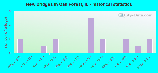
- New bridges - historical statistics
- 21900-1909
- 11920-1929
- 21930-1939
- 51960-1969
- 21970-1979
- 21990-1999
- 12000-2009
- 22010-2019

- Reconstructed bridges - Historical Statistics
- 21980-1989
- 11990-1999
- 12000-2009
- 22010-2019


- Bridge Condition - Deck
- 25.0%Excellent
- 25.0%Very good
- 25.0%Good
- 25.0%Satisfactory

- Bridge Condition - Superstructure
- 25.0%Good
- 25.0%Fair
- 25.0%Poor
- 25.0%Critical

- Bridge Condition - Channel
- 33.3%Very good
- 8.3%Good
- 33.3%Satisfactory
- 25.0%Fair

- Bridge Condition - Culverts
- 10.0%Excellent
- 10.0%Very good
- 60.0%Good
- 10.0%Satisfactory
- 10.0%Fair
Find on map >> Show street view
Structure Number: 160997, Location: .5 M S IL 83 (147TH) (Lat: 41.618406, Lng: -87.737039), Route carried "on" structure: State highway 50, Year Built: 1971, Status: Open, Structure Length: 0.73m (2.40ft), Average Daily Traffic: 25,400 (year 2021), Truck Traffic: 4%, Average Future Daily Traffic: 30,694 (year 2032), Design Load: HS 20, Features Intersected: CREEK N OF 151ST ST
Minimum Vertical Clearance: 30+ m (98+ ft), Kilometerpoint: 60.606, Lanes on structure: 5, Base Highway Network: Yes, Owner: State Highway Agency, Approaching Roadway Width: 18.3m (60.0ft), Skew: 20 degrees, Material/Design: Concrete continuous, Design/Construction: Culvert, Number Of Spans In Main Unit: 2, Length of Maximum Span: 3.4m (11.2ft), Curb or Sidewalk Widths: Left: 0.0m, Right: 1.2m (3.9ft)
Condition: Channel: Satisfactory, Culverts: Satisfactory, Operating Rating: 82.6 metric tons, Method Used To Determine Operating Rating: Load Factor (LF) rating reported by rating factor (RF) method using MS18 loading, Inventory Rating: 49.6 metric tons, Method Used To Determine Inventory Rating: Load Factor (LF) rating reported by rating factor (RF) method using MS18 loading, Structural Evaluation: Equal to present minimum criteria, Waterway Adequacy: Equal to present desirable criteria, Approach Roadway Alignment: Equal to present desirable criteria, Designated Inspection Frequency: Every 24 months, Inspection Date: Febuary 2022
Find on map >> Show street view
Structure Number: 161014, Location: 3.5 M SW I-294 (Lat: 41.582500, Lng: -87.734700), Route carried "on" structure: State highway 50, Year Built: 1967, Year Reconstructed: 2018, Status: Open, Structure Length: 7.84m (25.72ft), Average Daily Traffic: 17,500 (year 2021), Truck Traffic: 7%, Average Future Daily Traffic: 18,952 (year 2032), Design Load: HS 20, Features Intersected: I- 57
Minimum Vertical Clearance: 30+ m (98+ ft), Kilometerpoint: 56.583, Lanes on structure: 4, Lanes under structure: 7, Base Highway Network: Yes, Owner: State Highway Agency, Approaching Roadway Width: 19.5m (64.0ft), Skew: 32 degrees, Material/Design: Steel continuous, Design/Construction: Stringer/Multi-beam, Number Of Spans In Main Unit: 2, Number Of Approach Spans: 2, Length of Maximum Span: 31.9m (104.7ft), Curb-To-Curb Width: 19.5m (64.0ft), Out-to-Out Width: 25.4m (83.3ft)
Condition: Deck: Excellent, Superstructure: Fair, Substructure: Good, Operating Rating: 58.6 metric tons, Method Used To Determine Operating Rating: Load Factor (LF) rating reported by rating factor (RF) method using MS18 loading, Inventory Rating: 35.3 metric tons, Method Used To Determine Inventory Rating: Load Factor (LF) rating reported by rating factor (RF) method using MS18 loading, Structural Evaluation: Somewhat better than minimum adequacy, Deck Geometry: Better than present minimum criteria, Underclear: Somewhat better than minimum adequacy, Approach Roadway Alignment: Equal to present desirable criteria, Designated Inspection Frequency: Every 24 months, Inspection Date: March 2020, Deck Structure Type: Concrete Cast-file-Place, Wearing Surface/Protective System: Deck Protection: Epoxy Coated Reinforcing
Find on map >> Show street view
Structure Number: 162125, Location: 3 M SW I-294 (Lat: 41.587683, Lng: -87.728103), Route carried "on" structure: Other road , Year Built: 1968, Year Reconstructed: 2019, Status: Open, Structure Length: 10.05m (32.97ft), Average Daily Traffic: 16,000 (year 2018), Truck Traffic: 11%, Average Future Daily Traffic: 29,870 (year 2032), Design Load: HS 20, Features Intersected: I- 57, Facility Carried by Structure: 167TH ST
Minimum Vertical Clearance: 30+ m (98+ ft), Kilometerpoint: 5.504, Lanes on structure: 4, Lanes under structure: 10, Base Highway Network: Yes, Owner: State Highway Agency, Approaching Roadway Width: 21.9m (71.9ft), Skew: 21 degrees, Material/Design: Steel continuous, Design/Construction: Stringer/Multi-beam, Number Of Spans In Main Unit: 2, Number Of Approach Spans: 2, Length of Maximum Span: 35.6m (116.8ft), Curb-To-Curb Width: 25.9m (85.0ft), Out-to-Out Width: 27.8m (91.2ft)
Condition: Deck: Very good, Superstructure: Critical, Substructure: Good, Operating Rating: 63.8 metric tons, Method Used To Determine Operating Rating: Load Factor (LF) rating reported by rating factor (RF) method using MS18 loading, Inventory Rating: 38.2 metric tons, Method Used To Determine Inventory Rating: Load Factor (LF) rating reported by rating factor (RF) method using MS18 loading, Structural Evaluation: High priority of replacement, Deck Geometry: Superior to present desirable criteria, Underclear: Somewhat better than minimum adequacy, Approach Roadway Alignment: Equal to present desirable criteria, Designated Inspection Frequency: Every 12 months, Inspection Date: May 2021, Deck Structure Type: Concrete Cast-file-Place, Wearing Surface/Protective System: Deck Protection: Epoxy Coated Reinforcing
Find on map >> Show street view
Structure Number: 1624, Location: 0.2 M S 143RD ST (Lat: 41.628897, Lng: -87.795408), Route carried "on" structure: State highway 43, Year Built: 1925, Year Reconstructed: 2008, Status: Open, Structure Length: 1.16m (3.81ft), Average Daily Traffic: 30,200 (year 2021), Truck Traffic: 5%, Average Future Daily Traffic: 32,857 (year 2032), Design Load: HS 20, Features Intersected: TINLEY CREEK
Minimum Vertical Clearance: 30+ m (98+ ft), Kilometerpoint: 13.711, Lanes on structure: 4, Base Highway Network: Yes, Owner: State Highway Agency, Approaching Roadway Width: 17.1m (56.1ft), Skew: 33 degrees, Material/Design: Concrete continuous, Design/Construction: Culvert, Number Of Spans In Main Unit: 3, Length of Maximum Span: 3.8m (12.5ft)
Condition: Channel: Fair, Culverts: Fair, Operating Rating: 43.1 metric tons, Method Used To Determine Operating Rating: Field evaluation and documented engineering judgment, Inventory Rating: 25.9 metric tons, Method Used To Determine Inventory Rating: Field evaluation and documented engineering judgment, Structural Evaluation: Somewhat better than minimum adequacy, Waterway Adequacy: Equal to present desirable criteria, Approach Roadway Alignment: Equal to present desirable criteria, Length Of Structure Improvement: 1.37m (4.49ft), Designated Inspection Frequency: Every 24 months, Inspection Date: December 2021, Bridge Improvement Cost: $178,000, Roadway Improvement Cost: $18,000, Total Project Cost: $267,000, Deck Structure Type: Other
Find on map >> Show street view
Structure Number: 162711, Location: 0.1 M S OF 143RD ST (Lat: 41.630556, Lng: -87.784986), Route carried "on" structure: Other road , Year Built: 1999, Status: Open, Structure Length: 1.88m (6.17ft), Average Daily Traffic: 13,200 (year 2018), Truck Traffic: 4%, Average Future Daily Traffic: 5,768 (year 2032), Design Load: HS 20, Features Intersected: TINLEY CREEK, Facility Carried by Structure: OAK PARK AVE
Minimum Vertical Clearance: 30+ m (98+ ft), Kilometerpoint: 0.129, Lanes on structure: 2, Owner: State Highway Agency, Approaching Roadway Width: 11.0m (36.1ft), Material/Design: Prestressed concrete, Design/Construction: Box Beam or Girders - Multiple, Number Of Spans In Main Unit: 1, Length of Maximum Span: 17.6m (57.7ft), Curb-To-Curb Width: 11.0m (36.1ft), Out-to-Out Width: 11.0m (36.1ft)
Condition: Deck: Satisfactory, Superstructure: Good, Substructure: Good, Channel: Fair, Operating Rating: 73.2 metric tons, Method Used To Determine Operating Rating: Load Factor (LF) rating reported by rating factor (RF) method using MS18 loading, Inventory Rating: 43.7 metric tons, Method Used To Determine Inventory Rating: Load Factor (LF) rating reported by rating factor (RF) method using MS18 loading, Structural Evaluation: Better than present minimum criteria, Deck Geometry: Meets minimum limits, Waterway Adequacy: Superior to present desirable criteria, Approach Roadway Alignment: Equal to present desirable criteria, Designated Inspection Frequency: Every 48 months, Inspection Date: January 2021, Deck Structure Type: Concrete Cast-file-Place, Wearing Surface/Protective System: Wearing Surface: Integral Concrete, Deck Protection: Epoxy Coated Reinforcing
Find on map >> Show street view
Structure Number: 162846, Location: 1.7 MI W. ILL. 83 (Lat: 41.624617, Lng: -87.771583), Route carried "on" structure: Other road , Year Built: 2007, Status: Open, Structure Length: 0.86m (2.82ft), Average Daily Traffic: 11,100 (year 2018), Truck Traffic: 4%, Average Future Daily Traffic: 9,682 (year 2032), Design Load: HS 20, Features Intersected: BACA RIO DITCH, Facility Carried by Structure: 147TH ST
Minimum Vertical Clearance: 30+ m (98+ ft), Kilometerpoint: 1.915, Lanes on structure: 2, Base Highway Network: Yes, Owner: State Highway Agency, Approaching Roadway Width: 7.3m (24.0ft), Material/Design: Concrete, Design/Construction: Culvert, Number Of Spans In Main Unit: 2, Length of Maximum Span: 4.0m (13.1ft), Curb-To-Curb Width: 7.3m (24.0ft), Out-to-Out Width: 17.1m (56.1ft)
Condition: Channel: Satisfactory, Culverts: Good, Operating Rating: 44.1 metric tons, Method Used To Determine Operating Rating: Load Factor (LF) rating reported by rating factor (RF) method using MS18 loading, Inventory Rating: 32.4 metric tons, Method Used To Determine Inventory Rating: Load Factor (LF) rating reported by rating factor (RF) method using MS18 loading, Structural Evaluation: Better than present minimum criteria, Deck Geometry: High priority of replacement, Waterway Adequacy: Equal to present desirable criteria, Approach Roadway Alignment: Equal to present desirable criteria, Designated Inspection Frequency: Every 48 months, Inspection Date: Febuary 2020
Find on map >> Show street view
Structure Number: 162849, Location: .03 M W OF IL 50 (Lat: 41.603186, Lng: -87.736989), Route carried "on" structure: US 6, Year Built: 2018, Status: Open, Structure Length: 1.07m (3.51ft), Average Daily Traffic: 53,300 (year 2021), Truck Traffic: 3%, Average Future Daily Traffic: 54,468 (year 2042), Design Load: HS 25 or greater, Features Intersected: MIDLOTHIAN CR
Minimum Vertical Clearance: 30+ m (98+ ft), Kilometerpoint: 269.783, Lanes on structure: 8, Base Highway Network: Yes, Owner: State Highway Agency, Approaching Roadway Width: 22.6m (74.1ft), Skew: 2 degrees, Material/Design: Concrete continuous, Design/Construction: Culvert, Number Of Spans In Main Unit: 3, Length of Maximum Span: 3.0m (9.8ft), Curb-To-Curb Width: 22.6m (74.1ft)
Condition: Channel: Satisfactory, Culverts: Excellent, Operating Rating: 58.3 metric tons, Method Used To Determine Operating Rating: Load and Resistance Factor Rating (LRFR) rating reported by rating factor(RF) method using HL-93 loadings, Inventory Rating: 45.0 metric tons, Method Used To Determine Inventory Rating: Load and Resistance Factor Rating (LRFR) rating reported by rating factor(RF) method using HL-93 loadings, Structural Evaluation: Superior to present desirable criteria, Deck Geometry: High priority of replacement, Waterway Adequacy: Equal to present desirable criteria, Approach Roadway Alignment: Equal to present desirable criteria, Designated Inspection Frequency: Every 24 months, Inspection Date: June 2020
Find on map >> Show street view
Structure Number: 163069, Location: 0.75 W CENTRAL P3 (Lat: 41.631956, Lng: -87.772269), Route carried "on" structure: Other road , Year Built: 1931, Year Reconstructed: 1997, Status: Open, Structure Length: 0.98m (3.22ft), Average Daily Traffic: 14,300 (year 2018), Truck Traffic: 3%, Average Future Daily Traffic: 13,390 (year 2032), Design Load: HS 20, Features Intersected: BR OF TINLEY CREEK, Facility Carried by Structure: 143RD ST
Minimum Vertical Clearance: 30+ m (98+ ft), Kilometerpoint: 11.732, Lanes on structure: 4, Base Highway Network: Yes, Owner: County Highway Agency, Approaching Roadway Width: 17.1m (56.1ft), Skew: 30 degrees, Material/Design: Prestressed concrete, Design/Construction: Box Beam or Girders - Multiple, Number Of Spans In Main Unit: 1, Length of Maximum Span: 8.5m (27.9ft), Curb or Sidewalk Widths: Left: 3.0m (9.8ft), Right: 1.5m (4.9ft), Curb-To-Curb Width: 15.8m (51.8ft), Out-to-Out Width: 22.7m (74.5ft)
Condition: Deck: Good, Superstructure: Poor, Substructure: Good, Channel: Very good, Operating Rating: 78.4 metric tons, Method Used To Determine Operating Rating: Load Factor (LF) rating reported by rating factor (RF) method using MS18 loading, Inventory Rating: 47.0 metric tons, Method Used To Determine Inventory Rating: Load Factor (LF) rating reported by rating factor (RF) method using MS18 loading, Structural Evaluation: Meets minimum limits, Deck Geometry: Meets minimum limits, Waterway Adequacy: Equal to present desirable criteria, Approach Roadway Alignment: Equal to present desirable criteria, Designated Inspection Frequency: Every 24 months, Inspection Date: November 2021, Deck Structure Type: Concrete Cast-file-Place, Wearing Surface/Protective System: Wearing Surface: Integral Concrete, Deck Protection: Epoxy Coated Reinforcing
Find on map >> Show street view
Structure Number: 163246, Location: 0.25M.N.OF 143RD.ST. (Lat: 41.635353, Lng: -87.776644), Route carried "on" structure: Other road , Year Built: 1931, Year Reconstructed: 1994, Status: Open, Structure Length: 1.12m (3.67ft), Average Daily Traffic: 16,800 (year 2018), Truck Traffic: 3%, Average Future Daily Traffic: 19,879 (year 2032), Design Load: HS 20, Features Intersected: TINLEY CREEK, Facility Carried by Structure: RIDGELAND AVE.
Minimum Vertical Clearance: 30+ m (98+ ft), Kilometerpoint: 9.366, Lanes on structure: 4, Base Highway Network: Yes, Owner: County Highway Agency, Approaching Roadway Width: 17.1m (56.1ft), Skew: 23 degrees, Material/Design: Concrete continuous, Design/Construction: Culvert, Number Of Spans In Main Unit: 3, Length of Maximum Span: 3.9m (12.8ft)
Condition: Channel: Fair, Culverts: Good, Operating Rating: 89.1 metric tons, Method Used To Determine Operating Rating: Load Factor (LF) rating reported by rating factor (RF) method using MS18 loading, Inventory Rating: 89.1 metric tons, Method Used To Determine Inventory Rating: Load Factor (LF) rating reported by rating factor (RF) method using MS18 loading, Structural Evaluation: Better than present minimum criteria, Waterway Adequacy: Equal to present desirable criteria, Approach Roadway Alignment: Equal to present desirable criteria, Designated Inspection Frequency: Every 24 months, Inspection Date: August 2021
Find on map >> Show street view
Structure Number: 163259, Location: 0.3 M W OF RIDGELAND (Lat: 41.631733, Lng: -87.782694), Route carried "on" structure: Other road , Year Built: 1997, Status: Open, Structure Length: 2.56m (8.40ft), Average Daily Traffic: 20,100 (year 2018), Truck Traffic: 3%, Average Future Daily Traffic: 18,643 (year 2032), Design Load: HS 20, Features Intersected: TINLEY CREEK, Facility Carried by Structure: 143RD STREET
Minimum Vertical Clearance: 30+ m (98+ ft), Kilometerpoint: 10.782, Lanes on structure: 4, Base Highway Network: Yes, Owner: County Highway Agency, Approaching Roadway Width: 14.6m (47.9ft), Skew: 22 degrees, Material/Design: Concrete continuous, Design/Construction: Culvert, Number Of Spans In Main Unit: 3, Length of Maximum Span: 3.0m (9.8ft)
Condition: Channel: Good, Culverts: Good, Operating Rating: 54.1 metric tons, Method Used To Determine Operating Rating: Field evaluation and documented engineering judgment, Inventory Rating: 32.4 metric tons, Method Used To Determine Inventory Rating: Field evaluation and documented engineering judgment, Structural Evaluation: Better than present minimum criteria, Waterway Adequacy: Equal to present desirable criteria, Approach Roadway Alignment: Equal to present desirable criteria, Designated Inspection Frequency: Every 48 months, Inspection Date: June 2019
Find on map >> Show street view
Structure Number: 163272, Location: 0.4 MI E CENTRAL AVE (Lat: 41.588486, Lng: -87.748389), Route carried "on" structure: Other road , Year Built: 1973, Year Reconstructed: 1985, Status: Open, Structure Length: 3.07m (10.07ft), Average Daily Traffic: 22,700 (year 2018), Truck Traffic: 8%, Average Future Daily Traffic: 16,274 (year 2032), Design Load: HS 20, Features Intersected: MIDLOTHIAN CREEK, Facility Carried by Structure: 167TH STREET
Minimum Vertical Clearance: 30+ m (98+ ft), Kilometerpoint: 3.798, Lanes on structure: 4, Base Highway Network: Yes, Owner: County Highway Agency, Approaching Roadway Width: 15.8m (51.8ft), Skew: 3 degrees, Material/Design: Concrete, Design/Construction: Culvert, Number Of Spans In Main Unit: 2, Length of Maximum Span: 3.0m (9.8ft), Curb or Sidewalk Widths: Left: 3.7m (12.1ft), Right: 3.0m (9.8ft)
Condition: Channel: Satisfactory, Culverts: Good, Operating Rating: 55.4 metric tons, Method Used To Determine Operating Rating: Load Factor (LF) rating reported by rating factor (RF) method using MS18 loading, Inventory Rating: 33.0 metric tons, Method Used To Determine Inventory Rating: Load Factor (LF) rating reported by rating factor (RF) method using MS18 loading, Structural Evaluation: Better than present minimum criteria, Waterway Adequacy: Equal to present desirable criteria, Approach Roadway Alignment: Equal to present desirable criteria, Designated Inspection Frequency: Every 48 months, Inspection Date: July 2018
Find on map >> Show street view
Structure Number: 166027, Location: 0.1M NE IL. RTE 50 (Lat: 41.608933, Lng: -87.734603), Route carried "on" structure: City street , Year Built: 2012, Status: Open, Structure Length: 0.70m (2.30ft), Average Daily Traffic: 475 (year 2018), Truck Traffic: 5%, Average Future Daily Traffic: 250 (year 2032), Design Load: HS 25 or greater, Features Intersected: MIDLOTHIAN CREEK, Facility Carried by Structure: WAVERLY AVE
Minimum Vertical Clearance: 30+ m (98+ ft), Kilometerpoint: 0.241, Lanes on structure: 2, Owner: City or Municipal Highway Agency, Approaching Roadway Width: 7.3m (24.0ft), Skew: 4 degrees, Material/Design: Concrete, Design/Construction: Culvert, Number Of Spans In Main Unit: 2, Length of Maximum Span: 3.5m (11.5ft)
Condition: Channel: Very good, Culverts: Very good, Operating Rating: 53.5 metric tons, Method Used To Determine Operating Rating: Load and Resistance Factor Rating (LRFR) rating reported by rating factor(RF) method using HL-93 loadings, Inventory Rating: 41.1 metric tons, Method Used To Determine Inventory Rating: Load and Resistance Factor Rating (LRFR) rating reported by rating factor(RF) method using HL-93 loadings, Structural Evaluation: Equal to present desirable criteria, Waterway Adequacy: Equal to present desirable criteria, Approach Roadway Alignment: Equal to present desirable criteria, Designated Inspection Frequency: Every 48 months, Inspection Date: June 2019
Find on map >> Show street view
Structure Number: 16764, Location: 0.1 M S 151ST (Lat: 41.616400, Lng: -87.738558), Route carried "on" structure: City street , Year Built: 1967, Status: Open, Structure Length: 0.91m (2.99ft), Average Daily Traffic: 150 (year 2018), Truck Traffic: 15%, Average Future Daily Traffic: 318 (year 2032), Design Load: HS 20, Features Intersected: NATALIE CR, Facility Carried by Structure: LACROSSE AV
Minimum Vertical Clearance: 30+ m (98+ ft), Kilometerpoint: 0.161, Lanes on structure: 2, Owner: City or Municipal Highway Agency, Approaching Roadway Width: 8.5m (27.9ft), Skew: 6 degrees, Material/Design: Concrete, Design/Construction: Culvert, Number Of Spans In Main Unit: 2, Length of Maximum Span: 4.6m (15.1ft), Curb or Sidewalk Widths: Left: 1.7m (5.6ft), Right: 1.7m (5.6ft), Curb-To-Curb Width: 7.9m (25.9ft), Out-to-Out Width: 23.0m (75.5ft)
Condition: Channel: Very good, Culverts: Good, Operating Rating: 48.0 metric tons, Method Used To Determine Operating Rating: Load Factor (LF) rating reported by rating factor (RF) method using MS18 loading, Inventory Rating: 28.8 metric tons, Method Used To Determine Inventory Rating: Load Factor (LF) rating reported by rating factor (RF) method using MS18 loading, Structural Evaluation: Better than present minimum criteria, Deck Geometry: Somewhat better than minimum adequacy, Waterway Adequacy: Better than present minimum criteria, Approach Roadway Alignment: Equal to present desirable criteria, Designated Inspection Frequency: Every 24 months, Inspection Date: June 2021, Deck Structure Type: Concrete Cast-file-Place, Wearing Surface/Protective System: Wearing Surface: Bituminous
Find on map >> Show street view
Structure Number: 167641, Location: 0.1 M S 151ST (Lat: 41.616381, Lng: -87.740200), Route carried "on" structure: City street , Year Built: 1967, Status: Open, Structure Length: 0.85m (2.79ft), Average Daily Traffic: 225 (year 2018), Truck Traffic: 12%, Average Future Daily Traffic: 318 (year 2032), Design Load: HS 20, Features Intersected: NATALIE CR, Facility Carried by Structure: LAPORTE AV
Minimum Vertical Clearance: 30+ m (98+ ft), Kilometerpoint: 0.161, Lanes on structure: 2, Owner: City or Municipal Highway Agency, Approaching Roadway Width: 7.9m (25.9ft), Material/Design: Concrete, Design/Construction: Culvert, Number Of Spans In Main Unit: 2, Length of Maximum Span: 4.3m (14.1ft), Curb or Sidewalk Widths: Left: 1.4m (4.6ft), Right: 1.4m (4.6ft), Curb-To-Curb Width: 9.1m (29.9ft), Out-to-Out Width: 12.2m (40.0ft)
Condition: Channel: Very good, Culverts: Good, Operating Rating: 47.0 metric tons, Method Used To Determine Operating Rating: Load Factor (LF) rating reported by rating factor (RF) method using MS18 loading, Inventory Rating: 28.2 metric tons, Method Used To Determine Inventory Rating: Load Factor (LF) rating reported by rating factor (RF) method using MS18 loading, Structural Evaluation: Better than present minimum criteria, Deck Geometry: Equal to present minimum criteria, Waterway Adequacy: Equal to present minimum criteria, Approach Roadway Alignment: Equal to present desirable criteria, Designated Inspection Frequency: Every 24 months, Inspection Date: June 2021, Deck Structure Type: Concrete Cast-file-Place, Wearing Surface/Protective System: Wearing Surface: Bituminous
Find on map >> Show street view
Structure Number: 160382, Location: 0.2 M W ILL 50 P3 (Lat: 41.603136, Lng: -87.740161), Route carried "under" structure: US 6, Year Built: 1900, Structure Length: 0. m, Average Daily Traffic: 27,900 (year 2021), Truck Traffic: 3%, Features Intersected: US 6 (159TH ST), Facility Carried by Structure: CRI&P RR
Minimum Vertical Clearance: 4.32m (14.17ft), Kilometerpoint: 269.542, Lanes under structure: 4, Material/Design: Concrete, Length of Maximum Span: 15.8m (51.8ft)
Find on map >> Show street view
Structure Number: 160422, Location: 0.2 M N US 6 P3 (Lat: 41.606039, Lng: -87.736578), Route carried "under" structure: State highway 50, Year Built: 1900, Structure Length: 0. m, Average Daily Traffic: 25,400 (year 2021), Truck Traffic: 4%, Features Intersected: ILL 50 (CICERO AVE), Facility Carried by Structure: CRI&P RR
Minimum Vertical Clearance: 4.50m (14.76ft), Kilometerpoint: 59.222, Lanes under structure: 4, Material/Design: Steel, Length of Maximum Span: 22.3m (73.2ft)
Find on map >> Show street view
Structure Number: 162125, Location: 3 M SW I-294 (Lat: 41.587417, Lng: -87.727594), Route carried "under" structure: Interstate 57, Year Built: 1968, Structure Length: 0. m, Average Daily Traffic: 96,400 (year 2021), Truck Traffic: 5%, Features Intersected: I- 57, Facility Carried by Structure: 167TH ST
Minimum Vertical Clearance: 5.11m (16.77ft), Kilometerpoint: 557.783, Lanes on structure: 4, Lanes under structure: 10, Material/Design: Steel continuous, Design/Construction: Stringer/Multi-beam, Length of Maximum Span: 35.6m (116.8ft)