Bridge Statistics for Norwood, Massachusetts (MA)
Condition, Traffic, Stress, Structural Evaluation, Project Costs
- National Bridge Inventory (NBI) Statistics
- 23Number of bridges
- 167ft / 51.5mTotal length
- $42,292,000Total costs
- 726,045Total average daily traffic
- 30,952Total average daily truck traffic
- National Bridge Inventory (NBI) Registered Bridges for Norwood
- No street view available for this location
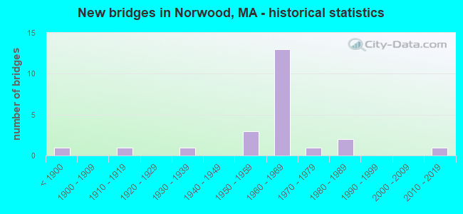
- New bridges - historical statistics
- 1Before 1900
- 11910-1919
- 11930-1939
- 31950-1959
- 131960-1969
- 11970-1979
- 21980-1989
- 12010-2019

- Reconstructed bridges - Historical Statistics
- 11920-1929
- 01930-1939
- 01940-1949
- 11950-1959
- 01960-1969
- 01970-1979
- 01980-1989
- 01990-1999
- 32000-2009


- Bridge Condition - Deck
- 5.9%Very good
- 23.5%Good
- 29.4%Satisfactory
- 41.2%Fair

- Bridge Condition - Superstructure
- 5.6%Very good
- 33.3%Good
- 33.3%Satisfactory
- 27.8%Fair

- Bridge Condition - Substructure
- 16.7%Very good
- 38.9%Good
- 33.3%Satisfactory
- 11.1%Fair

- Bridge Condition - Channel
- 63.6%Good
- 9.1%Satisfactory
- 9.1%Fair
- 9.1%Poor
- 9.1%Serious
Find on map >> Show street view
Structure Number: N250023JQMUNNBI, Location: .2 MI SO OF DEAN STREET (Lat: 42.177389, Lng: -71.200311), Route carried "on" structure: City street , Year Built: 1971, Status: Open, Structure Length: 1.31m (4.30ft), Average Daily Traffic: 12,672 (year 2021), Truck Traffic: 10%, Average Future Daily Traffic: 26,848 (year 2032), Design Load: H 20, Features Intersected: WATER NEPONSET RIVER, Facility Carried by Structure: HWY PLEASANT ST
Minimum Vertical Clearance: 30+ m (98+ ft), Kilometerpoint: 1.658, Lanes on structure: 2, Owner: Town or Township Highway Agency, Approaching Roadway Width: 8.5m (27.9ft), Material/Design: Prestressed concrete, Design/Construction: Slab, Number Of Spans In Main Unit: 1, Length of Maximum Span: 12.8m (42.0ft), Curb or Sidewalk Widths: Left: 1.8m (5.9ft), Right: 1.8m (5.9ft), Curb-To-Curb Width: 8.5m (27.9ft), Out-to-Out Width: 12.2m (40.0ft)
Condition: Deck: Satisfactory, Superstructure: Satisfactory, Substructure: Good, Channel: Fair, Operating Rating: 73.8 metric tons, Method Used To Determine Operating Rating: Allowable Stress (AS), Inventory Rating: 37.6 metric tons, Method Used To Determine Inventory Rating: Allowable Stress (AS), Structural Evaluation: Equal to present minimum criteria, Deck Geometry: High priority of replacement, Waterway Adequacy: Equal to present desirable criteria, Approach Roadway Alignment: Somewhat better than minimum adequacy, Length Of Structure Improvement: 1.40m (4.59ft), Designated Inspection Frequency: Every 24 months, Inspection Date: August 2021, Bridge Improvement Cost: $647,000, Roadway Improvement Cost: $65,000, Total Project Cost: $971,000 ( Estimate for 2022), Deck Structure Type: Concrete Precast Panels, Wearing Surface/Protective System: Wearing Surface: Bituminous, Membrane: Built-up
Find on map >> Show street view
Structure Number: N25003AYVMUNNBI, Location: .1 MI W OF PLEASANT ST (Lat: 42.172964, Lng: -71.204789), Route carried "on" structure: City street , Year Built: 2010, Status: Open, Structure Length: 1.34m (4.40ft), Average Daily Traffic: 8,500 (year 2019), Truck Traffic: 2%, Average Future Daily Traffic: 13,424 (year 2032), Design Load: HS 25 or greater, Features Intersected: WATER NEPONSET RIVER, Facility Carried by Structure: HWY MORSE ST
Minimum Vertical Clearance: 30+ m (98+ ft), Kilometerpoint: 0.515, Lanes on structure: 2, Owner: Town or Township Highway Agency, Approaching Roadway Width: 8.5m (27.9ft), Material/Design: Prestressed concrete, Design/Construction: Slab, Number Of Spans In Main Unit: 1, Length of Maximum Span: 12.3m (40.4ft), Curb or Sidewalk Widths: Left: 0.0m, Right: 1.7m (5.6ft), Curb-To-Curb Width: 6.6m (21.7ft), Out-to-Out Width: 9.1m (29.9ft)
Condition: Deck: Very good, Superstructure: Very good, Substructure: Very good, Channel: Good, Operating Rating: 87.4 metric tons, Method Used To Determine Operating Rating: Load Factor (LF), Inventory Rating: 49.8 metric tons, Method Used To Determine Inventory Rating: Load Factor (LF), Structural Evaluation: Equal to present desirable criteria, Deck Geometry: High priority of replacement, Waterway Adequacy: Somewhat better than minimum adequacy, Approach Roadway Alignment: Equal to present minimum criteria, Length Of Structure Improvement: 1.40m (4.59ft), Designated Inspection Frequency: Every 24 months, Inspection Date: January 2021, Bridge Improvement Cost: $896,000, Roadway Improvement Cost: $90,000, Total Project Cost: $1,345,000 ( Estimate for 2022), Deck Structure Type: Concrete Precast Panels, Wearing Surface/Protective System: Wearing Surface: Bituminous, Membrane: Built-up, Deck Protection: Epoxy Coated Reinforcing
Find on map >> Show street view
Structure Number: N250143PPDOTNBI, Location: .1 MI S OF UNIVERSITY AVE (Lat: 42.209092, Lng: -71.184678), Route carried "on" structure: US 1, Year Built: 1932, Year Reconstructed: 1956, Status: Open, Structure Length: 0.79m (2.59ft), Average Daily Traffic: 50,000 (year 2020), Truck Traffic: 6%, Average Future Daily Traffic: 59,382 (year 2033), Design Load: H 20, Features Intersected: WATER PURGATORY BROOK
Minimum Vertical Clearance: 30+ m (98+ ft), Kilometerpoint: 39.360, Lanes on structure: 4, Base Highway Network: Yes, Owner: State Highway Agency, Approaching Roadway Width: 20.7m (67.9ft), Skew: 23 degrees, Material/Design: Concrete, Design/Construction: Culvert, Number Of Spans In Main Unit: 2, Length of Maximum Span: 3.0m (9.8ft)
Condition: Channel: Serious, Culverts: Good, Operating Rating: 45.4 metric tons, Method Used To Determine Operating Rating: Load Factor (LF), Inventory Rating: 32.4 metric tons, Method Used To Determine Inventory Rating: Load Factor (LF), Structural Evaluation: Better than present minimum criteria, Waterway Adequacy: Somewhat better than minimum adequacy, Approach Roadway Alignment: Equal to present desirable criteria, Length Of Structure Improvement: 0.20m (0.66ft), Designated Inspection Frequency: Every 24 months, Underwater Inspection Frequency: Every 36 months, Inspection Date: January 2022, Underwater Inspection Date: July 2021, Bridge Improvement Cost: $118,000, Roadway Improvement Cost: $12,000, Total Project Cost: $178,000 ( Estimate for 2022)
Find on map >> Show street view
Structure Number: N250173JPMUNNBI, Location: .5 MI NE OF WALPOLE (Lat: 42.173972, Lng: -71.208100), Route carried "on" structure: City street , Year Built: 1967, Status: Open, Structure Length: 1.01m (3.31ft), Average Daily Traffic: 20,600 (year 2021), Truck Traffic: 2%, Average Future Daily Traffic: 31,586 (year 2032), Design Load: HS 20, Features Intersected: WATER HAWES BROOK, Facility Carried by Structure: HWY WASHNGTON ST
Minimum Vertical Clearance: 30+ m (98+ ft), Kilometerpoint: 0.000, Lanes on structure: 2, Owner: Town or Township Highway Agency, Approaching Roadway Width: 12.5m (41.0ft), Material/Design: Prestressed concrete, Design/Construction: Slab, Number Of Spans In Main Unit: 1, Length of Maximum Span: 9.8m (32.2ft), Curb or Sidewalk Widths: Left: 2.7m (8.9ft), Right: 2.4m (7.9ft), Curb-To-Curb Width: 12.8m (42.0ft), Out-to-Out Width: 18.3m (60.0ft)
Condition: Deck: Fair, Superstructure: Fair, Substructure: Good, Channel: Good, Operating Rating: 84.7 metric tons, Method Used To Determine Operating Rating: Allowable Stress (AS), Inventory Rating: 51.1 metric tons, Method Used To Determine Inventory Rating: Allowable Stress (AS), Structural Evaluation: Somewhat better than minimum adequacy, Deck Geometry: Somewhat better than minimum adequacy, Waterway Adequacy: Superior to present desirable criteria, Approach Roadway Alignment: Better than present minimum criteria, Length Of Structure Improvement: 1.10m (3.61ft), Designated Inspection Frequency: Every 24 months, Inspection Date: June 2021, Bridge Improvement Cost: $791,000, Roadway Improvement Cost: $80,000, Total Project Cost: $1,187,000 ( Estimate for 2022), Deck Structure Type: Concrete Precast Panels, Wearing Surface/Protective System: Wearing Surface: Bituminous, Membrane: Built-up
Find on map >> Show street view
Structure Number: N250223VVDOTNBI, Location: SOUTH BRIDGE (Lat: 42.187569, Lng: -71.184700), Route carried "on" structure: City street , Year Built: 1956, Year Reconstructed: 2005, Status: Open, Structure Length: 5.06m (16.60ft), Average Daily Traffic: 18,000 (year 2021), Truck Traffic: 6%, Average Future Daily Traffic: 25,585 (year 2032), Design Load: HS 20, Features Intersected: US 1 PROVDNCE HWY, Facility Carried by Structure: HWY PNDRGST C SO
Minimum Vertical Clearance: 30+ m (98+ ft), Kilometerpoint: 0.000, Lanes on structure: 1, Lanes under structure: 4, Base Highway Network: Yes, Owner: State Highway Agency, Approaching Roadway Width: 12.2m (40.0ft), Material/Design: Steel continuous, Design/Construction: Stringer/Multi-beam, Number Of Spans In Main Unit: 3, Length of Maximum Span: 26.8m (87.9ft), Curb or Sidewalk Widths: Left: 0.0m, Right: 1.8m (5.9ft), Curb-To-Curb Width: 12.2m (40.0ft), Out-to-Out Width: 14.7m (48.2ft)
Condition: Deck: Good, Superstructure: Good, Substructure: Very good, Operating Rating: 80.7 metric tons, Method Used To Determine Operating Rating: Load Factor (LF), Inventory Rating: 48.3 metric tons, Method Used To Determine Inventory Rating: Load Factor (LF), Structural Evaluation: Better than present minimum criteria, Deck Geometry: Somewhat better than minimum adequacy, Underclear: High priority of corrective action, Approach Roadway Alignment: Equal to present minimum criteria, Length Of Structure Improvement: 5.10m (16.73ft), Designated Inspection Frequency: Every 24 months, Inspection Date: April 2021, Bridge Improvement Cost: $578,000, Roadway Improvement Cost: $58,000, Total Project Cost: $868,000 ( Estimate for 2022), Deck Structure Type: Concrete Cast-file-Place, Wearing Surface/Protective System: Wearing Surface: Monolithic Concrete, Deck Protection: Epoxy Coated Reinforcing
Find on map >> Show street view
Structure Number: N250233VWDOTNBI, Location: NORTH BRIDGE (Lat: 42.188953, Lng: -71.184394), Route carried "on" structure: City street , Year Built: 1956, Year Reconstructed: 2005, Status: Open, Structure Length: 4.91m (16.11ft), Average Daily Traffic: 14,250 (year 2021), Truck Traffic: 9%, Average Future Daily Traffic: 25,585 (year 2032), Design Load: HS 20, Features Intersected: US 1 PROVDNCE HWY, Facility Carried by Structure: HWY PNDRGST C NO
Minimum Vertical Clearance: 30+ m (98+ ft), Kilometerpoint: 0.000, Lanes on structure: 1, Lanes under structure: 4, Base Highway Network: Yes, Owner: State Highway Agency, Approaching Roadway Width: 12.2m (40.0ft), Material/Design: Steel continuous, Design/Construction: Stringer/Multi-beam, Number Of Spans In Main Unit: 3, Length of Maximum Span: 26.8m (87.9ft), Curb or Sidewalk Widths: Left: 0.0m, Right: 1.7m (5.6ft), Curb-To-Curb Width: 12.2m (40.0ft), Out-to-Out Width: 14.7m (48.2ft)
Condition: Deck: Good, Superstructure: Good, Substructure: Very good, Operating Rating: 79.4 metric tons, Method Used To Determine Operating Rating: Load Factor (LF), Inventory Rating: 48.3 metric tons, Method Used To Determine Inventory Rating: Load Factor (LF), Structural Evaluation: Better than present minimum criteria, Deck Geometry: Somewhat better than minimum adequacy, Underclear: High priority of corrective action, Approach Roadway Alignment: Equal to present minimum criteria, Length Of Structure Improvement: 5.00m (16.40ft), Designated Inspection Frequency: Every 24 months, Inspection Date: April 2021, Bridge Improvement Cost: $566,000, Roadway Improvement Cost: $57,000, Total Project Cost: $850,000 ( Estimate for 2022), Deck Structure Type: Concrete Cast-file-Place, Wearing Surface/Protective System: Wearing Surface: Monolithic Concrete, Deck Protection: Epoxy Coated Reinforcing
Find on map >> Show street view
Structure Number: N250263PNDOTNBI, Location: .25 MI S OF DEAN ST (Lat: 42.176953, Lng: -71.191994), Route carried "on" structure: US 1, Year Built: 1960, Status: Open, Structure Length: 1.98m (6.50ft), Average Daily Traffic: 45,258 (year 2022), Truck Traffic: 9%, Average Future Daily Traffic: 56,223 (year 2032), Design Load: H 20, Features Intersected: WATER NEPONSET RIVER
Minimum Vertical Clearance: 30+ m (98+ ft), Kilometerpoint: 35.680, Lanes on structure: 4, Base Highway Network: Yes, Owner: State Highway Agency, Approaching Roadway Width: 21.3m (69.9ft), Skew: 33 degrees, Material/Design: Steel, Design/Construction: Stringer/Multi-beam, Number Of Spans In Main Unit: 1, Length of Maximum Span: 18.6m (61.0ft), Curb or Sidewalk Widths: Left: 1.5m (4.9ft), Right: 0.6m (2.0ft), Curb-To-Curb Width: 21.3m (69.9ft), Out-to-Out Width: 25.8m (84.6ft)
Condition: Deck: Fair, Superstructure: Good, Substructure: Good, Channel: Good, Operating Rating: 50.6 metric tons, Method Used To Determine Operating Rating: Load Factor (LF), Inventory Rating: 30.3 metric tons, Method Used To Determine Inventory Rating: Load Factor (LF), Structural Evaluation: Better than present minimum criteria, Deck Geometry: Superior to present desirable criteria, Waterway Adequacy: Equal to present desirable criteria, Approach Roadway Alignment: Equal to present desirable criteria, Length Of Structure Improvement: 2.00m (6.56ft), Designated Inspection Frequency: Every 24 months, Inspection Date: October 2021, Bridge Improvement Cost: $2,027,000, Roadway Improvement Cost: $203,000, Total Project Cost: $3,041,000 ( Estimate for 2022), Deck Structure Type: Concrete Cast-file-Place, Wearing Surface/Protective System: Wearing Surface: Bituminous, Membrane: Built-up
Find on map >> Show street view
Structure Number: N250283R1DOTNBI, Location: .3 MI N OF WALPOLE T.L. (Lat: 42.153381, Lng: -71.190225), Route carried "on" structure: Interstate 95, Year Built: 1963, Status: Open, Structure Length: 3.14m (10.30ft), Average Daily Traffic: 53,991 (year 2019), Truck Traffic: 5%, Average Future Daily Traffic: 75,806 (year 2032), Design Load: HS 20+Mod, Features Intersected: HWY UNION ST
Minimum Vertical Clearance: 30+ m (98+ ft), Kilometerpoint: 34.600, Lanes on structure: 3, Lanes under structure: 2, Base Highway Network: Yes, Owner: State Highway Agency, Approaching Roadway Width: 15.2m (49.9ft), Skew: 1 degrees, Material/Design: Steel, Design/Construction: Stringer/Multi-beam, Number Of Spans In Main Unit: 3, Length of Maximum Span: 14.0m (45.9ft), Curb-To-Curb Width: 16.5m (54.1ft), Out-to-Out Width: 17.2m (56.4ft)
Condition: Deck: Satisfactory, Superstructure: Satisfactory, Substructure: Satisfactory, Operating Rating: 57.2 metric tons, Method Used To Determine Operating Rating: Load Factor (LF), Inventory Rating: 34.3 metric tons, Method Used To Determine Inventory Rating: Load Factor (LF), Structural Evaluation: Equal to present minimum criteria, Deck Geometry: Equal to present minimum criteria, Underclear: High priority of corrective action, Approach Roadway Alignment: Equal to present desirable criteria, Length Of Structure Improvement: 3.20m (10.50ft), Designated Inspection Frequency: Every 24 months, Inspection Date: January 2021, Bridge Improvement Cost: $574,000, Roadway Improvement Cost: $58,000, Total Project Cost: $862,000 ( Estimate for 2022), Deck Structure Type: Concrete Cast-file-Place, Wearing Surface/Protective System: Wearing Surface: Bituminous, Membrane: Built-up
Find on map >> Show street view
Structure Number: N250283R2DOTNBI, Location: .3 MI N OF WALPOLE T.L. (Lat: 42.153722, Lng: -71.190525), Route carried "on" structure: Interstate 95, Year Built: 1963, Status: Open, Structure Length: 3.14m (10.30ft), Average Daily Traffic: 56,741 (year 2019), Truck Traffic: 5%, Average Future Daily Traffic: 75,806 (year 2032), Design Load: HS 20+Mod, Features Intersected: HWY UNION ST
Minimum Vertical Clearance: 30+ m (98+ ft), Kilometerpoint: 34.600, Lanes on structure: 3, Lanes under structure: 2, Base Highway Network: Yes, Owner: State Highway Agency, Approaching Roadway Width: 15.2m (49.9ft), Skew: 1 degrees, Material/Design: Steel, Design/Construction: Stringer/Multi-beam, Number Of Spans In Main Unit: 3, Length of Maximum Span: 14.0m (45.9ft), Curb-To-Curb Width: 16.5m (54.1ft), Out-to-Out Width: 17.2m (56.4ft)
Condition: Deck: Satisfactory, Superstructure: Satisfactory, Substructure: Satisfactory, Operating Rating: 53.5 metric tons, Method Used To Determine Operating Rating: Load Factor (LF), Inventory Rating: 32.0 metric tons, Method Used To Determine Inventory Rating: Load Factor (LF), Structural Evaluation: Equal to present minimum criteria, Deck Geometry: Equal to present minimum criteria, Underclear: High priority of corrective action, Approach Roadway Alignment: Equal to present desirable criteria, Length Of Structure Improvement: 3.20m (10.50ft), Designated Inspection Frequency: Every 24 months, Inspection Date: January 2021, Bridge Improvement Cost: $2,162,000, Roadway Improvement Cost: $217,000, Total Project Cost: $3,244,000 ( Estimate for 2022), Deck Structure Type: Concrete Cast-file-Place, Wearing Surface/Protective System: Wearing Surface: Bituminous, Membrane: Built-up
Find on map >> Show street view
Structure Number: N250303VTDOTNBI, Location: .6 MI N OF SHARON T.L. (Lat: 42.170942, Lng: -71.170828), Route carried "on" structure: City street , Year Built: 1963, Status: Open, Structure Length: 2.44m (8.01ft), Average Daily Traffic: 25,200 (year 2020), Truck Traffic: 4%, Average Future Daily Traffic: 62,066 (year 2032), Design Load: H 20, Features Intersected: I 95 NB, Facility Carried by Structure: HWY NEPONSET ST
Minimum Vertical Clearance: 30+ m (98+ ft), Kilometerpoint: 2.414, Lanes on structure: 4, Lanes under structure: 4, Base Highway Network: Yes, Owner: State Highway Agency, Approaching Roadway Width: 24.4m (80.1ft), Skew: 20 degrees, Material/Design: Steel, Design/Construction: Stringer/Multi-beam, Number Of Spans In Main Unit: 1, Length of Maximum Span: 23.2m (76.1ft), Curb or Sidewalk Widths: Left: 1.5m (4.9ft), Right: 0.5m (1.6ft), Curb-To-Curb Width: 23.8m (78.1ft), Out-to-Out Width: 26.5m (86.9ft)
Condition: Deck: Satisfactory, Superstructure: Fair, Substructure: Satisfactory, Operating Rating: 76.1 metric tons, Method Used To Determine Operating Rating: Load Factor (LF), Inventory Rating: 45.6 metric tons, Method Used To Determine Inventory Rating: Load Factor (LF), Structural Evaluation: Somewhat better than minimum adequacy, Deck Geometry: Superior to present desirable criteria, Underclear: High priority of corrective action, Approach Roadway Alignment: Equal to present desirable criteria, Length Of Structure Improvement: 2.50m (8.20ft), Designated Inspection Frequency: Every 24 months, Inspection Date: March 2021, Bridge Improvement Cost: $2,603,000, Roadway Improvement Cost: $261,000, Total Project Cost: $3,905,000 ( Estimate for 2022), Deck Structure Type: Concrete Cast-file-Place, Wearing Surface/Protective System: Wearing Surface: Bituminous, Membrane: Built-up
Find on map >> Show street view
Structure Number: N250303VUDOTNBI, Location: .6 MI N OF SHARON T.L. (Lat: 42.171194, Lng: -71.171278), Route carried "on" structure: City street , Year Built: 1963, Status: Open, Structure Length: 2.44m (8.01ft), Average Daily Traffic: 25,200 (year 2020), Truck Traffic: 4%, Average Future Daily Traffic: 34,745 (year 2032), Design Load: H 20, Features Intersected: I 95 SB, Facility Carried by Structure: HWY NEPONSET ST
Minimum Vertical Clearance: 30+ m (98+ ft), Kilometerpoint: 2.414, Lanes on structure: 4, Lanes under structure: 4, Base Highway Network: Yes, Owner: State Highway Agency, Approaching Roadway Width: 24.4m (80.1ft), Skew: 20 degrees, Material/Design: Steel, Design/Construction: Stringer/Multi-beam, Number Of Spans In Main Unit: 1, Length of Maximum Span: 23.2m (76.1ft), Curb or Sidewalk Widths: Left: 1.5m (4.9ft), Right: 0.5m (1.6ft), Curb-To-Curb Width: 23.8m (78.1ft), Out-to-Out Width: 26.5m (86.9ft)
Condition: Deck: Satisfactory, Superstructure: Fair, Substructure: Satisfactory, Operating Rating: 74.7 metric tons, Method Used To Determine Operating Rating: Load Factor (LF), Inventory Rating: 44.8 metric tons, Method Used To Determine Inventory Rating: Load Factor (LF), Structural Evaluation: Somewhat better than minimum adequacy, Deck Geometry: Superior to present desirable criteria, Underclear: High priority of corrective action, Approach Roadway Alignment: Equal to present desirable criteria, Length Of Structure Improvement: 2.50m (8.20ft), Designated Inspection Frequency: Every 24 months, Inspection Date: March 2021, Bridge Improvement Cost: $2,603,000, Roadway Improvement Cost: $261,000, Total Project Cost: $3,905,000 ( Estimate for 2022), Deck Structure Type: Concrete Cast-file-Place, Wearing Surface/Protective System: Wearing Surface: Bituminous, Membrane: Built-up
Find on map >> Show street view
Structure Number: N250313R3DOTNBI, Location: N. OF NEPONSET ST/95 (Lat: 42.175431, Lng: -71.166731), Route carried "on" structure: Interstate 95, Year Built: 1963, Status: Open, Structure Length: 3.90m (12.80ft), Average Daily Traffic: 61,777 (year 2019), Truck Traffic: 5%, Average Future Daily Traffic: 80,228 (year 2032), Design Load: HS 20, Features Intersected: WATER NEPONSET RIVER
Minimum Vertical Clearance: 30+ m (98+ ft), Kilometerpoint: 38.055, Lanes on structure: 3, Base Highway Network: Yes, Owner: State Highway Agency, Approaching Roadway Width: 15.8m (51.8ft), Skew: 1 degrees, Material/Design: Steel, Design/Construction: Stringer/Multi-beam, Number Of Spans In Main Unit: 3, Length of Maximum Span: 19.2m (63.0ft), Curb or Sidewalk Widths: Left: 0.5m (1.6ft), Right: 0.5m (1.6ft), Curb-To-Curb Width: 15.8m (51.8ft), Out-to-Out Width: 17.7m (58.1ft)
Condition: Deck: Fair, Superstructure: Satisfactory, Substructure: Good, Channel: Good, Operating Rating: 45.7 metric tons, Method Used To Determine Operating Rating: Load Factor (LF), Inventory Rating: 27.4 metric tons, Method Used To Determine Inventory Rating: Load Factor (LF), Structural Evaluation: Equal to present minimum criteria, Deck Geometry: Somewhat better than minimum adequacy, Waterway Adequacy: Better than present minimum criteria, Approach Roadway Alignment: Better than present minimum criteria, Length Of Structure Improvement: 4.00m (13.12ft), Designated Inspection Frequency: Every 24 months, Underwater Inspection Frequency: Every 36 months, Inspection Date: October 2021, Underwater Inspection Date: August 2019, Bridge Improvement Cost: $2,782,000, Roadway Improvement Cost: $279,000, Total Project Cost: $4,174,000 ( Estimate for 2022), Deck Structure Type: Concrete Cast-file-Place, Wearing Surface/Protective System: Wearing Surface: Bituminous, Membrane: Built-up
Find on map >> Show street view
Structure Number: N250313R4DOTNBI, Location: N. OF NEPONSET ST/95 (Lat: 42.175889, Lng: -71.167011), Route carried "on" structure: Interstate 95, Year Built: 1963, Status: Open, Structure Length: 3.90m (12.80ft), Average Daily Traffic: 63,800 (year 2019), Truck Traffic: 5%, Average Future Daily Traffic: 80,228 (year 2032), Design Load: HS 20, Features Intersected: WATER NEPONSET RIVER
Minimum Vertical Clearance: 30+ m (98+ ft), Kilometerpoint: 38.055, Lanes on structure: 3, Base Highway Network: Yes, Owner: State Highway Agency, Approaching Roadway Width: 15.2m (49.9ft), Skew: 1 degrees, Material/Design: Steel, Design/Construction: Stringer/Multi-beam, Number Of Spans In Main Unit: 3, Length of Maximum Span: 19.2m (63.0ft), Curb or Sidewalk Widths: Left: 0.5m (1.6ft), Right: 0.5m (1.6ft), Curb-To-Curb Width: 15.2m (49.9ft), Out-to-Out Width: 17.1m (56.1ft)
Condition: Deck: Fair, Superstructure: Satisfactory, Substructure: Satisfactory, Channel: Good, Operating Rating: 46.5 metric tons, Method Used To Determine Operating Rating: Load Factor (LF), Inventory Rating: 27.9 metric tons, Method Used To Determine Inventory Rating: Load Factor (LF), Structural Evaluation: Equal to present minimum criteria, Deck Geometry: Meets minimum limits, Waterway Adequacy: Better than present minimum criteria, Approach Roadway Alignment: Equal to present desirable criteria, Length Of Structure Improvement: 4.00m (13.12ft), Designated Inspection Frequency: Every 24 months, Underwater Inspection Frequency: Every 36 months, Inspection Date: October 2021, Underwater Inspection Date: August 2019, Bridge Improvement Cost: $2,687,000, Roadway Improvement Cost: $269,000, Total Project Cost: $4,031,000 ( Estimate for 2022), Deck Structure Type: Concrete Cast-file-Place, Wearing Surface/Protective System: Wearing Surface: Bituminous, Membrane: Built-up
Find on map >> Show street view
Structure Number: N2503240MDOT634, Location: R 128 IND PRK LEAD MP QBL (Lat: 42.199333, Lng: -71.158864), Route carried "on" structure: City street , Year Built: 1966, Status: Open, Structure Length: 2.29m (7.51ft), Average Daily Traffic: 12,100 (year 2020), Truck Traffic: 4%, Average Future Daily Traffic: 19,425 (year 2033), Design Load: H 20, Features Intersected: RR CSX SPUR QBL 2.18, Facility Carried by Structure: HWY CANTON ST
Minimum Vertical Clearance: 30+ m (98+ ft), Kilometerpoint: 0.032, Lanes on structure: 2, Owner: State Highway Agency, Approaching Roadway Width: 13.4m (44.0ft), Skew: 4 degrees, Material/Design: Steel, Design/Construction: Stringer/Multi-beam, Number Of Spans In Main Unit: 1, Length of Maximum Span: 21.3m (69.9ft), Curb or Sidewalk Widths: Left: 1.9m (6.2ft), Right: 1.9m (6.2ft), Curb-To-Curb Width: 13.4m (44.0ft), Out-to-Out Width: 17.9m (58.7ft)
Condition: Deck: Fair, Superstructure: Good, Substructure: Good, Operating Rating: 58.8 metric tons, Method Used To Determine Operating Rating: Load Factor (LF), Inventory Rating: 35.2 metric tons, Method Used To Determine Inventory Rating: Load Factor (LF), Structural Evaluation: Better than present minimum criteria, Deck Geometry: Equal to present minimum criteria, Underclear: High priority of corrective action, Approach Roadway Alignment: Equal to present desirable criteria, Length Of Structure Improvement: 2.30m (7.55ft), Designated Inspection Frequency: Every 24 months, Inspection Date: January 2022, Bridge Improvement Cost: $777,000, Roadway Improvement Cost: $78,000, Total Project Cost: $1,166,000 ( Estimate for 2022), Deck Structure Type: Concrete Cast-file-Place, Wearing Surface/Protective System: Wearing Surface: Monolithic Concrete
Find on map >> Show street view
Structure Number: W03010415DOT634, Location: .2 MI SW OF ST 1A (Lat: 42.167144, Lng: -71.225683), Route carried "on" structure: City street , Year Built: 1985, Status: Open, Structure Length: 1.55m (5.09ft), Average Daily Traffic: 6,000 (year 2019), Truck Traffic: 6%, Average Future Daily Traffic: 22,110 (year 2033), Design Load: HS 20, Features Intersected: RR MBTA/CSX, Facility Carried by Structure: HWY MYLOD ST
Minimum Vertical Clearance: 30+ m (98+ ft), Kilometerpoint: 0.193, Lanes on structure: 2, Owner: State Highway Agency, Approaching Roadway Width: 10.4m (34.1ft), Skew: 2 degrees, Material/Design: Prestressed concrete, Design/Construction: Slab, Number Of Spans In Main Unit: 1, Length of Maximum Span: 14.6m (47.9ft), Curb or Sidewalk Widths: Left: 0.2m (0.7ft), Right: 1.6m (5.2ft), Curb-To-Curb Width: 10.4m (34.1ft), Out-to-Out Width: 12.9m (42.3ft)
Condition: Deck: Fair, Superstructure: Fair, Substructure: Satisfactory, Operating Rating: 65.1 metric tons, Method Used To Determine Operating Rating: Load Factor (LF), Inventory Rating: 39.2 metric tons, Method Used To Determine Inventory Rating: Load Factor (LF), Structural Evaluation: Somewhat better than minimum adequacy, Deck Geometry: Meets minimum limits, Underclear: High priority of corrective action, Approach Roadway Alignment: High priority of corrective action, Length Of Structure Improvement: 1.60m (5.25ft), Designated Inspection Frequency: Every 24 months, Inspection Date: Febuary 2022, Bridge Improvement Cost: $811,000, Roadway Improvement Cost: $82,000, Total Project Cost: $1,217,000 ( Estimate for 2022), Deck Structure Type: Concrete Precast Panels, Wearing Surface/Protective System: Wearing Surface: Bituminous, Membrane: Built-up
Find on map >> Show street view
Structure Number: W030223KBMUNNBI, Location: .4 MI S OF NORWOOD (Lat: 42.162636, Lng: -71.215353), Route carried "on" structure: City street , Year Built: 1875, Year Reconstructed: 1926, Status: Open, Structure Length: 1.10m (3.61ft), Average Daily Traffic: 16,785 (year 2021), Truck Traffic: 6%, Average Future Daily Traffic: 27,638 (year 2031), Features Intersected: WATER NEPONSET RIVER, Facility Carried by Structure: HWY WASHNGTON ST
Minimum Vertical Clearance: 30+ m (98+ ft), Kilometerpoint: 7.435, Lanes on structure: 2, Owner: Town or Township Highway Agency, Approaching Roadway Width: 9.4m (30.8ft), Skew: 1 degrees, Material/Design: Masonry, Design/Construction: Arch - Deck, Number Of Spans In Main Unit: 2, Length of Maximum Span: 4.9m (16.1ft), Curb or Sidewalk Widths: Left: 0.6m (2.0ft), Right: 2.0m (6.6ft), Curb-To-Curb Width: 9.4m (30.8ft), Out-to-Out Width: 14.1m (46.3ft)
Condition: Superstructure: Fair, Substructure: Fair, Channel: Satisfactory, Structural Evaluation: Somewhat better than minimum adequacy, Deck Geometry: High priority of corrective action, Waterway Adequacy: Equal to present desirable criteria, Approach Roadway Alignment: Equal to present desirable criteria, Length Of Structure Improvement: 1.20m (3.94ft), Designated Inspection Frequency: Every 24 months, Underwater Inspection Frequency: Every 36 months, Inspection Date: August 2021, Underwater Inspection Date: August 2020, Bridge Improvement Cost: $665,000, Roadway Improvement Cost: $67,000, Total Project Cost: $998,000 ( Estimate for 2022)
Find on map >> Show street view
Structure Number: W030313KGMUNNBI, Location: .5 MI WEST OF RTE 1 (Lat: 42.157586, Lng: -71.208906), Route carried "on" structure: City street , Year Built: 1956, Status: Open, Structure Length: 0.70m (2.30ft), Average Daily Traffic: 5,500 (year 2021), Truck Traffic: 3%, Average Future Daily Traffic: 12,634 (year 2032), Design Load: H 20, Features Intersected: WATER TRAPHOLE BROOK, Facility Carried by Structure: HWY CONEY ST
Minimum Vertical Clearance: 30+ m (98+ ft), Kilometerpoint: 0.225, Lanes on structure: 2, Owner: Town or Township Highway Agency, Approaching Roadway Width: 7.3m (24.0ft), Material/Design: Prestressed concrete, Design/Construction: Slab, Number Of Spans In Main Unit: 1, Length of Maximum Span: 6.4m (21.0ft), Curb or Sidewalk Widths: Left: 1.2m (3.9ft), Right: 1.5m (4.9ft), Curb-To-Curb Width: 8.0m (26.2ft), Out-to-Out Width: 9.7m (31.8ft)
Condition: Deck: Good, Superstructure: Good, Substructure: Good, Channel: Good, Inventory Rating: 73.2 metric tons, Method Used To Determine Inventory Rating: Allowable Stress (AS), Structural Evaluation: Better than present minimum criteria, Deck Geometry: High priority of replacement, Waterway Adequacy: Equal to present desirable criteria, Approach Roadway Alignment: Equal to present minimum criteria, Length Of Structure Improvement: 0.80m (2.62ft), Designated Inspection Frequency: Every 24 months, Inspection Date: July 2021, Bridge Improvement Cost: $408,000, Roadway Improvement Cost: $41,000, Total Project Cost: $613,000 ( Estimate for 2022), Deck Structure Type: Concrete Precast Panels, Wearing Surface/Protective System: Wearing Surface: Bituminous, Membrane: Built-up
Find on map >> Show street view
Structure Number: W030333WLDOTNBI, Location: .5 MI SE OF US 1 (Lat: 42.148156, Lng: -71.200706), Route carried "on" structure: City street , Year Built: 1963, Status: Posted for load, Structure Length: 8.63m (28.31ft), Average Daily Traffic: 14,500 (year 2019), Truck Traffic: 4%, Average Future Daily Traffic: 34,745 (year 2032), Design Load: H 20, Features Intersected: I 95, Facility Carried by Structure: HWY CONEY ST
Minimum Vertical Clearance: 30+ m (98+ ft), Kilometerpoint: 0.000, Lanes on structure: 2, Lanes under structure: 6, Base Highway Network: Yes, Owner: State Highway Agency, Approaching Roadway Width: 13.4m (44.0ft), Skew: 2 degrees, Material/Design: Steel, Design/Construction: Stringer/Multi-beam, Number Of Spans In Main Unit: 5, Length of Maximum Span: 23.8m (78.1ft), Curb or Sidewalk Widths: Left: 1.9m (6.2ft), Right: 1.9m (6.2ft), Curb-To-Curb Width: 13.4m (44.0ft), Out-to-Out Width: 17.2m (56.4ft)
Condition: Deck: Fair, Superstructure: Satisfactory, Substructure: Fair, Operating Rating: 39.6 metric tons, Method Used To Determine Operating Rating: Allowable Stress (AS), Inventory Rating: 20.7 metric tons, Method Used To Determine Inventory Rating: Allowable Stress (AS), Structural Evaluation: Somewhat better than minimum adequacy, Deck Geometry: Equal to present minimum criteria, Underclear: High priority of corrective action, Approach Roadway Alignment: Equal to present desirable criteria, Length Of Structure Improvement: 8.70m (28.54ft), Designated Inspection Frequency: Every 24 months, Inspection Date: October 2021, Bridge Improvement Cost: $5,878,000, Roadway Improvement Cost: $588,000, Total Project Cost: $8,818,000 ( Estimate for 2022), Deck Structure Type: Concrete Cast-file-Place, Wearing Surface/Protective System: Wearing Surface: Bituminous, Membrane: Built-up
Find on map >> Show street view
Structure Number: W030373KCMUNNBI, Location: JCT W OF RTE 1A (Lat: 42.180394, Lng: -71.232989), Route carried "on" structure: City street , Year Built: 1911, Year Reconstructed: 2007, Status: Posted for load, Structure Length: 1.05m (3.44ft), Average Daily Traffic: 7,371 (year 2022), Truck Traffic: 5%, Average Future Daily Traffic: 4,738 (year 2033), Design Load: HS 20, Features Intersected: WATER WILLETT POND OTLT, Facility Carried by Structure: HWY BULLARD ST
Minimum Vertical Clearance: 30+ m (98+ ft), Kilometerpoint: 1.432, Lanes on structure: 2, Owner: Town or Township Highway Agency, Approaching Roadway Width: 7.2m (23.6ft), Material/Design: Steel, Design/Construction: Stringer/Multi-beam, Number Of Spans In Main Unit: 1, Length of Maximum Span: 9.1m (29.9ft), Curb-To-Curb Width: 7.5m (24.6ft), Out-to-Out Width: 8.4m (27.6ft)
Condition: Deck: Good, Superstructure: Good, Substructure: Good, Channel: Good, Operating Rating: 86.1 metric tons, Method Used To Determine Operating Rating: Load Factor (LF), Inventory Rating: 51.6 metric tons, Method Used To Determine Inventory Rating: Load Factor (LF), Structural Evaluation: Better than present minimum criteria, Deck Geometry: High priority of replacement, Waterway Adequacy: Better than present minimum criteria, Approach Roadway Alignment: Somewhat better than minimum adequacy, Length Of Structure Improvement: 1.10m (3.61ft), Designated Inspection Frequency: Every 24 months, Inspection Date: Febuary 2022, Bridge Improvement Cost: $612,000, Roadway Improvement Cost: $62,000, Total Project Cost: $919,000 ( Estimate for 2022), Deck Structure Type: Concrete Cast-file-Place, Wearing Surface/Protective System: Wearing Surface: Bituminous, Membrane: Built-up, Deck Protection: Epoxy Coated Reinforcing
Find on map >> Show street view
Structure Number: W030413PUDOTNBI, Location: .2 MI S OF CONEY ST (Lat: 42.151858, Lng: -71.209114), Route carried "on" structure: US 1, Year Built: 1984, Status: Open, Structure Length: 0.77m (2.53ft), Average Daily Traffic: 47,900 (year 2019), Truck Traffic: 6%, Average Future Daily Traffic: 60,013 (year 2032), Design Load: HS 20+Mod, Features Intersected: WATER TRAPHOLE BROOK
Minimum Vertical Clearance: 30+ m (98+ ft), Kilometerpoint: 0.129, Lanes on structure: 4, Base Highway Network: Yes, Owner: State Highway Agency, Approaching Roadway Width: 24.4m (80.1ft), Skew: 33 degrees, Material/Design: Concrete, Design/Construction: Culvert, Number Of Spans In Main Unit: 2, Length of Maximum Span: 3.0m (9.8ft)
Condition: Channel: Poor, Culverts: Good, Structural Evaluation: Better than present minimum criteria, Waterway Adequacy: Equal to present desirable criteria, Approach Roadway Alignment: Equal to present desirable criteria, Designated Inspection Frequency: Every 24 months, Inspection Date: October 2021
Find on map >> Show street view
Structure Number: N250303VTDOTNBI, Location: 000063 STATUTORY (Lat: 42.166667, Lng: -71.166667), Route carried "under" structure: Interstate 95, Year Built: 1963, Structure Length: 0. m, Average Daily Traffic: 59,450 (year 0000), Features Intersected: I 95 NB, Facility Carried by Structure: HWY NEPONSET ST
Minimum Vertical Clearance: 5.03m (16.50ft), Kilometerpoint: 0.000, Lanes on structure: 3, Lanes under structure: 4, Material/Design: Steel, Design/Construction: Stringer/Multi-beam, Length of Maximum Span: 23.2m (76.1ft)
Find on map >> Show street view
Structure Number: N250303VUDOTNBI, Location: 000063 STATUTORY (Lat: 42.166667, Lng: -71.166667), Route carried "under" structure: Interstate 95, Year Built: 1963, Structure Length: 0. m, Average Daily Traffic: 59,450 (year 0000), Features Intersected: I 95 SB, Facility Carried by Structure: HWY NEPONSET ST
Minimum Vertical Clearance: 5.79m (19.00ft), Kilometerpoint: 0.000, Lanes on structure: 3, Lanes under structure: 4, Material/Design: Steel, Design/Construction: Stringer/Multi-beam, Length of Maximum Span: 23.2m (76.1ft)
Find on map >> Show street view
Structure Number: W030333WLDOTNBI, Location: 000063 STATUTORY (Lat: 42.150000, Lng: -71.200000), Route carried "under" structure: Interstate 95, Year Built: 1963, Structure Length: 0. m, Average Daily Traffic: 41,000 (year 0000), Features Intersected: I 95 NB, Facility Carried by Structure: HWY CONEY ST
Minimum Vertical Clearance: 5.03m (16.50ft), Kilometerpoint: 0.000, Lanes on structure: 2, Lanes under structure: 2, Material/Design: Steel, Design/Construction: Stringer/Multi-beam, Length of Maximum Span: 18.9m (62.0ft)