Bridge Statistics for Northborough, Massachusetts (MA)
Condition, Traffic, Stress, Structural Evaluation, Project Costs
- National Bridge Inventory (NBI) Statistics
- 18Number of bridges
- 148ft / 44.9mTotal length
- $35,462,000Total costs
- 396,443Total average daily traffic
- 29,699Total average daily truck traffic
- National Bridge Inventory (NBI) Registered Bridges for Northborough
- No street view available for this location
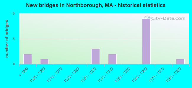
- New bridges - historical statistics
- 2Before 1900
- 11900-1909
- 31930-1939
- 21940-1949
- 91960-1969
- 11980-1989

- Reconstructed bridges - Historical Statistics
- 11960-1969
- 01970-1979
- 01980-1989
- 21990-1999
- 22000-2009


- Bridge Condition - Deck
- 6.7%Very good
- 26.7%Good
- 46.7%Satisfactory
- 20.0%Fair

- Bridge Condition - Superstructure
- 13.3%Good
- 53.3%Satisfactory
- 33.3%Fair

- Bridge Condition - Substructure
- 40.0%Good
- 40.0%Satisfactory
- 20.0%Fair

- Bridge Condition - Channel
- 14.3%Very good
- 42.9%Good
- 28.6%Satisfactory
- 14.3%Fair
Find on map >> Show street view
Structure Number: N200011GTMUNNBI, Location: 150 FT. S. OF HUDSON ST. (Lat: 42.323281, Lng: -71.638000), Route carried "on" structure: City street , Year Built: 1961, Status: Posted for load, Structure Length: 1.83m (6.00ft), Average Daily Traffic: 600 (year 2015), Truck Traffic: 1%, Average Future Daily Traffic: 948 (year 2032), Design Load: H 20, Features Intersected: WATER ASSABET RIVER, Facility Carried by Structure: HWY RIVER ST
Minimum Vertical Clearance: 30+ m (98+ ft), Kilometerpoint: 0.483, Lanes on structure: 2, Owner: Town or Township Highway Agency, Approaching Roadway Width: 9.1m (29.9ft), Material/Design: Concrete continuous, Design/Construction: Slab, Number Of Spans In Main Unit: 3, Length of Maximum Span: 5.5m (18.0ft), Curb or Sidewalk Widths: Left: 1.5m (4.9ft), Right: 0.6m (2.0ft), Curb-To-Curb Width: 9.1m (29.9ft), Out-to-Out Width: 11.4m (37.4ft)
Condition: Deck: Satisfactory, Superstructure: Satisfactory, Substructure: Good, Channel: Good, Operating Rating: 27.5 metric tons, Method Used To Determine Operating Rating: Load Factor (LF), Inventory Rating: 16.5 metric tons, Method Used To Determine Inventory Rating: Load Factor (LF), Structural Evaluation: Meets minimum limits, Deck Geometry: Equal to present minimum criteria, Waterway Adequacy: Equal to present desirable criteria, Approach Roadway Alignment: Better than present minimum criteria, Bridge Posting: Required (Relationship of Operating Rating to Maximum Legal Load: 10.0 - 19.9% below), Length Of Structure Improvement: 1.90m (6.23ft), Designated Inspection Frequency: Every 24 months, Inspection Date: July 2021, Bridge Improvement Cost: $851,000, Roadway Improvement Cost: $86,000, Total Project Cost: $1,277,000 ( Estimate for 2022), Deck Structure Type: Concrete Cast-file-Place, Wearing Surface/Protective System: Wearing Surface: Bituminous, Membrane: Built-up
Find on map >> Show street view
Structure Number: N200021CVMUNNBI, Location: AT CORNER OF HUDSON ST. (Lat: 42.329511, Lng: -71.630017), Route carried "on" structure: City street , Year Built: 1986, Year Reconstructed: 2007, Status: Open, Structure Length: 1.95m (6.40ft), Average Daily Traffic: 3,514 (year 2020), Truck Traffic: 7%, Average Future Daily Traffic: 4,896 (year 2032), Design Load: HS 25 or greater, Features Intersected: WATER ASSABET RIVER, Facility Carried by Structure: HWY ALLEN ST
Minimum Vertical Clearance: 30+ m (98+ ft), Kilometerpoint: 0.209, Lanes on structure: 2, Owner: Town or Township Highway Agency, Approaching Roadway Width: 9.8m (32.2ft), Material/Design: Prestressed concrete, Design/Construction: Box Beam or Girders - Multiple, Number Of Spans In Main Unit: 1, Length of Maximum Span: 17.7m (58.1ft), Curb or Sidewalk Widths: Left: 0.0m, Right: 1.5m (4.9ft), Curb-To-Curb Width: 9.8m (32.2ft), Out-to-Out Width: 12.3m (40.4ft)
Condition: Deck: Very good, Superstructure: Good, Substructure: Good, Channel: Satisfactory, Operating Rating: 88.2 metric tons, Method Used To Determine Operating Rating: Load Factor (LF), Inventory Rating: 52.8 metric tons, Method Used To Determine Inventory Rating: Load Factor (LF), Structural Evaluation: Better than present minimum criteria, Deck Geometry: Meets minimum limits, Waterway Adequacy: Better than present minimum criteria, Approach Roadway Alignment: Better than present minimum criteria, Length Of Structure Improvement: 2.00m (6.56ft), Designated Inspection Frequency: Every 24 months, Underwater Inspection Frequency: Every 36 months, Inspection Date: August 2021, Underwater Inspection Date: March 2019, Bridge Improvement Cost: $679,000, Roadway Improvement Cost: $68,000, Total Project Cost: $1,019,000 ( Estimate for 2022), Deck Structure Type: Concrete Cast-file-Place, Wearing Surface/Protective System: Wearing Surface: Bituminous, Membrane: Built-up, Deck Protection: Epoxy Coated Reinforcing
Find on map >> Show street view
Structure Number: N200031GUMUNNBI, Location: 1 MI. S. OF RT. 20 (Lat: 42.309103, Lng: -71.629500), Route carried "on" structure: City street , Year Built: 1940, Status: Open, Structure Length: 0.98m (3.22ft), Average Daily Traffic: 2,544 (year 2019), Truck Traffic: 3%, Average Future Daily Traffic: 7,423 (year 2031), Features Intersected: WATER ASSABET RIVER, Facility Carried by Structure: HWY BRIGHAM ST
Minimum Vertical Clearance: 30+ m (98+ ft), Kilometerpoint: 1.250, Lanes on structure: 2, Owner: Town or Township Highway Agency, Approaching Roadway Width: 7.0m (23.0ft), Material/Design: Steel, Design/Construction: Culvert, Number Of Spans In Main Unit: 2, Length of Maximum Span: 4.0m (13.1ft)
Condition: Channel: Satisfactory, Culverts: Fair, Structural Evaluation: Somewhat better than minimum adequacy, Waterway Adequacy: Better than present minimum criteria, Approach Roadway Alignment: Meets minimum limits, Length Of Structure Improvement: 0.80m (2.62ft), Designated Inspection Frequency: Every 24 months, Inspection Date: December 2020, Bridge Improvement Cost: $308,000, Roadway Improvement Cost: $31,000, Total Project Cost: $463,000 ( Estimate for 2022)
Find on map >> Show street view
Structure Number: N2000420DDOTNBI, Location: AT WESTBORO TOWN LINE (Lat: 42.294458, Lng: -71.637278), Route carried "on" structure: State highway 135, Year Built: 1947, Status: Open, Structure Length: 2.19m (7.19ft), Average Daily Traffic: 9,124 (year 2018), Truck Traffic: 4%, Average Future Daily Traffic: 15,003 (year 2033), Features Intersected: WATER ASSABET RIVER
Minimum Vertical Clearance: 30+ m (98+ ft), Kilometerpoint: 3.059, Lanes on structure: 2, Owner: State Highway Agency, Approaching Roadway Width: 9.1m (29.9ft), Material/Design: Concrete continuous, Design/Construction: Slab, Number Of Spans In Main Unit: 4, Length of Maximum Span: 5.3m (17.4ft), Curb or Sidewalk Widths: Left: 0.7m (2.3ft), Right: 0.7m (2.3ft), Curb-To-Curb Width: 9.1m (29.9ft), Out-to-Out Width: 11.6m (38.1ft)
Condition: Deck: Fair, Superstructure: Fair, Substructure: Fair, Channel: Fair, Operating Rating: 70.2 metric tons, Method Used To Determine Operating Rating: Load Factor (LF), Inventory Rating: 42.0 metric tons, Method Used To Determine Inventory Rating: Load Factor (LF), Structural Evaluation: Somewhat better than minimum adequacy, Deck Geometry: High priority of corrective action, Waterway Adequacy: Equal to present desirable criteria, Approach Roadway Alignment: Equal to present desirable criteria, Length Of Structure Improvement: 2.20m (7.22ft), Designated Inspection Frequency: Every 24 months, Underwater Inspection Frequency: Every 36 months, Inspection Date: Febuary 2022, Underwater Inspection Date: August 2019, Bridge Improvement Cost: $1,003,000, Roadway Improvement Cost: $101,000, Total Project Cost: $1,505,000 ( Estimate for 2022), Deck Structure Type: Concrete Cast-file-Place, Wearing Surface/Protective System: Wearing Surface: Bituminous
Find on map >> Show street view
Structure Number: N200051GVMUNNBI, Location: 0.1M W OF RT135 (Lat: 42.293933, Lng: -71.637694), Route carried "on" structure: City street , Year Built: 1850, Year Reconstructed: 1971, Status: Open, Structure Length: 1.04m (3.41ft), Average Daily Traffic: 3,653 (year 2018), Truck Traffic: 1%, Average Future Daily Traffic: 11,087 (year 2032), Design Load: H 20, Features Intersected: WATER ASSABET RIVER, Facility Carried by Structure: HWY DAVIS ST
Minimum Vertical Clearance: 30+ m (98+ ft), Kilometerpoint: 3.186, Lanes on structure: 2, Owner: Town or Township Highway Agency, Approaching Roadway Width: 5.8m (19.0ft), Material/Design: Prestressed concrete, Design/Construction: Slab, Number Of Spans In Main Unit: 1, Length of Maximum Span: 10.1m (33.1ft), Curb or Sidewalk Widths: Left: 0.3m (1.0ft), Right: 0.3m (1.0ft), Curb-To-Curb Width: 6.7m (22.0ft), Out-to-Out Width: 7.3m (24.0ft)
Condition: Deck: Fair, Superstructure: Fair, Substructure: Satisfactory, Channel: Good, Operating Rating: 65.5 metric tons, Method Used To Determine Operating Rating: Allowable Stress (AS), Inventory Rating: 31.8 metric tons, Method Used To Determine Inventory Rating: Allowable Stress (AS), Structural Evaluation: Somewhat better than minimum adequacy, Deck Geometry: High priority of replacement, Waterway Adequacy: Better than present minimum criteria, Approach Roadway Alignment: Equal to present minimum criteria, Length Of Structure Improvement: 1.10m (3.61ft), Designated Inspection Frequency: Every 24 months, Inspection Date: July 2021, Bridge Improvement Cost: $316,000, Roadway Improvement Cost: $32,000, Total Project Cost: $475,000 ( Estimate for 2022), Deck Structure Type: Concrete Precast Panels, Wearing Surface/Protective System: Wearing Surface: Bituminous, Membrane: Built-up
Find on map >> Show street view
Structure Number: N2000822DDOT634, Location: 1.1MI.STH.OF US-20 (Lat: 42.313278, Lng: -71.613528), Route carried "on" structure: City street , Year Built: 1900, Year Reconstructed: 1995, Status: Open, Structure Length: 1.62m (5.31ft), Average Daily Traffic: 3,600 (year 2014), Truck Traffic: 8%, Average Future Daily Traffic: 5,685 (year 2031), Design Load: HS 20, Features Intersected: RR CSX, Facility Carried by Structure: HWY LYMAN ST
Minimum Vertical Clearance: 30+ m (98+ ft), Kilometerpoint: 0.000, Lanes on structure: 2, Owner: State Highway Agency, Approaching Roadway Width: 7.3m (24.0ft), Material/Design: Prestressed concrete, Design/Construction: Slab, Number Of Spans In Main Unit: 1, Length of Maximum Span: 14.9m (48.9ft), Curb or Sidewalk Widths: Left: 0.0m, Right: 1.5m (4.9ft), Curb-To-Curb Width: 7.3m (24.0ft), Out-to-Out Width: 9.8m (32.2ft)
Condition: Deck: Satisfactory, Superstructure: Satisfactory, Substructure: Good, Operating Rating: 67.1 metric tons, Method Used To Determine Operating Rating: Load Factor (LF), Inventory Rating: 47.4 metric tons, Method Used To Determine Inventory Rating: Load Factor (LF), Structural Evaluation: Equal to present minimum criteria, Deck Geometry: High priority of replacement, Underclear: Meets minimum limits, Approach Roadway Alignment: Better than present minimum criteria, Length Of Structure Improvement: 1.70m (5.58ft), Designated Inspection Frequency: Every 24 months, Inspection Date: April 2020, Bridge Improvement Cost: $978,000, Roadway Improvement Cost: $98,000, Total Project Cost: $1,468,000 ( Estimate for 2022), Deck Structure Type: Concrete Precast Panels, Wearing Surface/Protective System: Wearing Surface: Bituminous, Membrane: Preformed Fabric, Deck Protection: Epoxy Coated Reinforcing
Find on map >> Show street view
Structure Number: N2000922BDOT634, Location: .25 MI E OF WHITNEY ST (Lat: 42.328297, Lng: -71.640019), Route carried "on" structure: City street , Year Built: 1880, Year Reconstructed: 1996, Status: Open, Structure Length: 0.73m (2.40ft), Average Daily Traffic: 600 (year 2013), Truck Traffic: 1%, Average Future Daily Traffic: 948 (year 2032), Design Load: HS 20, Features Intersected: RR CSX, Facility Carried by Structure: HWY RICE AVE
Minimum Vertical Clearance: 30+ m (98+ ft), Kilometerpoint: 0.402, Lanes on structure: 2, Owner: State Highway Agency, Approaching Roadway Width: 6.1m (20.0ft), Skew: 1 degrees, Material/Design: Steel, Design/Construction: Stringer/Multi-beam, Number Of Spans In Main Unit: 1, Length of Maximum Span: 6.0m (19.7ft), Curb-To-Curb Width: 6.1m (20.0ft), Out-to-Out Width: 7.1m (23.3ft)
Condition: Deck: Good, Superstructure: Good, Substructure: Satisfactory, Operating Rating: 54.1 metric tons, Method Used To Determine Operating Rating: Load Factor (LF), Inventory Rating: 32.4 metric tons, Method Used To Determine Inventory Rating: Load Factor (LF), Structural Evaluation: Equal to present minimum criteria, Deck Geometry: High priority of corrective action, Underclear: High priority of corrective action, Approach Roadway Alignment: Better than present minimum criteria, Length Of Structure Improvement: 0.80m (2.62ft), Designated Inspection Frequency: Every 24 months, Inspection Date: April 2021, Bridge Improvement Cost: $461,000, Roadway Improvement Cost: $47,000, Total Project Cost: $692,000 ( Estimate for 2022), Deck Structure Type: Concrete Precast Panels, Wearing Surface/Protective System: Wearing Surface: Bituminous, Membrane: Built-up, Deck Protection: Epoxy Coated Reinforcing
Find on map >> Show street view
Structure Number: N200161LYDOTNBI, Location: 1000 FT E OF SHREWSBRY TL (Lat: 42.282694, Lng: -71.670053), Route carried "on" structure: State highway 9, Year Built: 1930, Status: Open, Structure Length: 2.01m (6.59ft), Average Daily Traffic: 51,882 (year 2019), Truck Traffic: 3%, Average Future Daily Traffic: 61,593 (year 2032), Design Load: H 20, Features Intersected: US 20 SOUTHWEST CUTOFF
Minimum Vertical Clearance: 30+ m (98+ ft), Kilometerpoint: 167.061, Lanes on structure: 4, Lanes under structure: 2, Base Highway Network: Yes, Owner: State Highway Agency, Approaching Roadway Width: 21.3m (69.9ft), Skew: 34 degrees, Material/Design: Steel, Design/Construction: Stringer/Multi-beam, Number Of Spans In Main Unit: 1, Length of Maximum Span: 17.8m (58.4ft), Curb or Sidewalk Widths: Left: 0.2m (0.7ft), Right: 0.2m (0.7ft), Curb-To-Curb Width: 21.3m (69.9ft), Out-to-Out Width: 22.9m (75.1ft)
Condition: Deck: Satisfactory, Superstructure: Fair, Substructure: Good, Operating Rating: 46.8 metric tons, Method Used To Determine Operating Rating: Allowable Stress (AS), Inventory Rating: 19.8 metric tons, Method Used To Determine Inventory Rating: Allowable Stress (AS), Structural Evaluation: Somewhat better than minimum adequacy, Deck Geometry: Superior to present desirable criteria, Underclear: High priority of corrective action, Approach Roadway Alignment: Equal to present desirable criteria, Length Of Structure Improvement: 2.10m (6.89ft), Designated Inspection Frequency: Every 24 months, Inspection Date: December 2021, Bridge Improvement Cost: $1,889,000, Roadway Improvement Cost: $189,000, Total Project Cost: $2,834,000 ( Estimate for 2022), Deck Structure Type: Concrete Cast-file-Place, Wearing Surface/Protective System: Wearing Surface: Bituminous, Membrane: Built-up
Find on map >> Show street view
Structure Number: N200171KYDOTNBI, Location: 0.3 MI W OF BARTLETT ST (Lat: 42.326214, Lng: -71.625239), Route carried "on" structure: US 20, Year Built: 1931, Year Reconstructed: 2014, Status: Open, Structure Length: 1.55m (5.09ft), Average Daily Traffic: 13,137 (year 2019), Truck Traffic: 7%, Average Future Daily Traffic: 28,112 (year 2033), Design Load: HS 20, Features Intersected: WATER WACHUSETT AQUEDUCT
Minimum Vertical Clearance: 30+ m (98+ ft), Kilometerpoint: 200.002, Lanes on structure: 2, Base Highway Network: Yes, Owner: State Highway Agency, Approaching Roadway Width: 12.5m (41.0ft), Skew: 3 degrees, Material/Design: Concrete, Design/Construction: Tee Beam, Number Of Spans In Main Unit: 1, Length of Maximum Span: 14.0m (45.9ft), Curb-To-Curb Width: 12.5m (41.0ft), Out-to-Out Width: 13.4m (44.0ft)
Condition: Deck: Good, Superstructure: Satisfactory, Substructure: Good, Channel: Very good, Operating Rating: 69.9 metric tons, Method Used To Determine Operating Rating: Load Factor (LF), Inventory Rating: 41.8 metric tons, Method Used To Determine Inventory Rating: Load Factor (LF), Structural Evaluation: Equal to present minimum criteria, Deck Geometry: Somewhat better than minimum adequacy, Approach Roadway Alignment: Equal to present desirable criteria, Designated Inspection Frequency: Every 24 months, Inspection Date: November 2020, Deck Structure Type: Concrete Cast-file-Place, Wearing Surface/Protective System: Wearing Surface: Bituminous
Find on map >> Show street view
Structure Number: N200211R4DOTNBI, Location: I-290 WB/CHURCH S (Lat: 42.332658, Lng: -71.680108), Route carried "on" structure: Interstate 290, Year Built: 1968, Status: Open, Structure Length: 4.79m (15.72ft), Average Daily Traffic: 43,560 (year 2019), Truck Traffic: 7%, Average Future Daily Traffic: 61,593 (year 2031), Design Load: HS 20, Features Intersected: HWY CHURCH ST
Minimum Vertical Clearance: 30+ m (98+ ft), Kilometerpoint: 24.091, Lanes on structure: 4, Lanes under structure: 2, Base Highway Network: Yes, Owner: State Highway Agency, Approaching Roadway Width: 16.8m (55.1ft), Skew: 4 degrees, Material/Design: Steel, Design/Construction: Stringer/Multi-beam, Number Of Spans In Main Unit: 3, Length of Maximum Span: 24.7m (81.0ft), Curb-To-Curb Width: 16.8m (55.1ft), Out-to-Out Width: 18.6m (61.0ft)
Condition: Deck: Fair, Superstructure: Satisfactory, Substructure: Fair, Operating Rating: 54.9 metric tons, Method Used To Determine Operating Rating: Load Factor (LF), Inventory Rating: 32.9 metric tons, Method Used To Determine Inventory Rating: Load Factor (LF), Structural Evaluation: Somewhat better than minimum adequacy, Deck Geometry: High priority of replacement, Underclear: Meets minimum limits, Approach Roadway Alignment: Equal to present desirable criteria, Length Of Structure Improvement: 4.80m (15.75ft), Designated Inspection Frequency: Every 24 months, Inspection Date: June 2020, Bridge Improvement Cost: $3,507,000, Roadway Improvement Cost: $351,000, Total Project Cost: $5,261,000 ( Estimate for 2022), Deck Structure Type: Concrete Cast-file-Place, Wearing Surface/Protective System: Wearing Surface: Bituminous, Membrane: Built-up
Find on map >> Show street view
Structure Number: N200211R5DOTNBI, Location: I-290 EB/ CHURCH ST (Lat: 42.332369, Lng: -71.679747), Route carried "on" structure: Interstate 290, Year Built: 1968, Status: Open, Structure Length: 4.72m (15.49ft), Average Daily Traffic: 39,000 (year 2014), Truck Traffic: 15%, Average Future Daily Traffic: 61,593 (year 2031), Design Load: HS 20, Features Intersected: HWY CHURCH ST
Minimum Vertical Clearance: 30+ m (98+ ft), Kilometerpoint: 24.091, Lanes on structure: 3, Lanes under structure: 2, Base Highway Network: Yes, Owner: State Highway Agency, Approaching Roadway Width: 16.8m (55.1ft), Skew: 4 degrees, Material/Design: Steel, Design/Construction: Stringer/Multi-beam, Number Of Spans In Main Unit: 3, Length of Maximum Span: 24.7m (81.0ft), Curb or Sidewalk Widths: Left: 0.2m (0.7ft), Right: 0.2m (0.7ft), Curb-To-Curb Width: 15.8m (51.8ft), Out-to-Out Width: 17.1m (56.1ft)
Condition: Deck: Good, Superstructure: Satisfactory, Substructure: Fair, Operating Rating: 57.6 metric tons, Method Used To Determine Operating Rating: Load Factor (LF), Inventory Rating: 34.5 metric tons, Method Used To Determine Inventory Rating: Load Factor (LF), Structural Evaluation: Somewhat better than minimum adequacy, Deck Geometry: Somewhat better than minimum adequacy, Underclear: Meets minimum limits, Approach Roadway Alignment: Equal to present desirable criteria, Length Of Structure Improvement: 4.80m (15.75ft), Designated Inspection Frequency: Every 24 months, Inspection Date: June 2020, Bridge Improvement Cost: $3,225,000, Roadway Improvement Cost: $323,000, Total Project Cost: $4,838,000 ( Estimate for 2022), Deck Structure Type: Concrete Cast-file-Place, Wearing Surface/Protective System: Wearing Surface: Bituminous, Membrane: Built-up
Find on map >> Show street view
Structure Number: N2002320XDOTNBI, Location: .5 MI N OF HOWARD ST. (Lat: 42.336400, Lng: -71.660067), Route carried "on" structure: City street , Year Built: 1968, Status: Open, Structure Length: 9.91m (32.51ft), Average Daily Traffic: 1,300 (year 2013), Truck Traffic: 5%, Average Future Daily Traffic: 2,053 (year 2032), Design Load: H 20, Features Intersected: I 290, Facility Carried by Structure: HWY GREEN ST
Minimum Vertical Clearance: 30+ m (98+ ft), Kilometerpoint: 3.380, Lanes on structure: 2, Lanes under structure: 6, Owner: State Highway Agency, Approaching Roadway Width: 9.8m (32.2ft), Skew: 3 degrees, Material/Design: Steel, Design/Construction: Stringer/Multi-beam, Number Of Spans In Main Unit: 3, Length of Maximum Span: 33.5m (109.9ft), Curb or Sidewalk Widths: Left: 0.0m, Right: 1.5m (4.9ft), Curb-To-Curb Width: 9.8m (32.2ft), Out-to-Out Width: 12.7m (41.7ft)
Condition: Deck: Good, Superstructure: Fair, Substructure: Satisfactory, Operating Rating: 55.9 metric tons, Method Used To Determine Operating Rating: Load Factor (LF), Inventory Rating: 33.5 metric tons, Method Used To Determine Inventory Rating: Load Factor (LF), Structural Evaluation: Somewhat better than minimum adequacy, Deck Geometry: Somewhat better than minimum adequacy, Underclear: High priority of corrective action, Approach Roadway Alignment: Equal to present desirable criteria, Length Of Structure Improvement: 10.00m (32.81ft), Designated Inspection Frequency: Every 24 months, Inspection Date: June 2021, Bridge Improvement Cost: $4,989,000, Roadway Improvement Cost: $499,000, Total Project Cost: $7,484,000 ( Estimate for 2022), Deck Structure Type: Concrete Cast-file-Place, Wearing Surface/Protective System: Wearing Surface: Bituminous, Membrane: Built-up
Find on map >> Show street view
Structure Number: N200241R6DOTNBI, Location: .7 MI.W. SOLOMON POND (Lat: 42.342022, Lng: -71.642006), Route carried "on" structure: Interstate 290, Year Built: 1968, Status: Open, Structure Length: 2.42m (7.94ft), Average Daily Traffic: 65,423 (year 2020), Truck Traffic: 15%, Average Future Daily Traffic: 61,593 (year 2032), Design Load: HS 20+Mod, Features Intersected: HWY WHITNEY ST
Minimum Vertical Clearance: 30+ m (98+ ft), Kilometerpoint: 27.397, Lanes on structure: 3, Lanes under structure: 2, Base Highway Network: Yes, Owner: State Highway Agency, Approaching Roadway Width: 15.7m (51.5ft), Skew: 1 degrees, Material/Design: Steel, Design/Construction: Stringer/Multi-beam, Number Of Spans In Main Unit: 1, Length of Maximum Span: 22.7m (74.5ft), Curb-To-Curb Width: 15.7m (51.5ft), Out-to-Out Width: 17.1m (56.1ft)
Condition: Deck: Satisfactory, Superstructure: Fair, Substructure: Satisfactory, Operating Rating: 49.5 metric tons, Method Used To Determine Operating Rating: Allowable Stress (AS), Inventory Rating: 32.4 metric tons, Method Used To Determine Inventory Rating: Allowable Stress (AS), Structural Evaluation: Somewhat better than minimum adequacy, Deck Geometry: Somewhat better than minimum adequacy, Underclear: Meets minimum limits, Approach Roadway Alignment: Equal to present desirable criteria, Length Of Structure Improvement: 2.50m (8.20ft), Designated Inspection Frequency: Every 24 months, Inspection Date: November 2021, Bridge Improvement Cost: $1,680,000, Roadway Improvement Cost: $169,000, Total Project Cost: $2,521,000 ( Estimate for 2022), Deck Structure Type: Concrete Cast-file-Place, Wearing Surface/Protective System: Wearing Surface: Bituminous, Membrane: Built-up
Find on map >> Show street view
Structure Number: N200241R7DOTNBI, Location: I-290 WB MM 17.1 (Lat: 42.342442, Lng: -71.641947), Route carried "on" structure: Interstate 290, Year Built: 1968, Status: Open, Structure Length: 2.50m (8.20ft), Average Daily Traffic: 32,382 (year 2020), Truck Traffic: 9%, Average Future Daily Traffic: 61,593 (year 2032), Design Load: HS 20+Mod, Features Intersected: HWY WHITNEY ST
Minimum Vertical Clearance: 30+ m (98+ ft), Kilometerpoint: 27.558, Lanes on structure: 3, Lanes under structure: 2, Base Highway Network: Yes, Owner: State Highway Agency, Approaching Roadway Width: 15.2m (49.9ft), Skew: 2 degrees, Material/Design: Steel, Design/Construction: Stringer/Multi-beam, Number Of Spans In Main Unit: 1, Length of Maximum Span: 23.5m (77.1ft), Curb-To-Curb Width: 15.2m (49.9ft), Out-to-Out Width: 17.4m (57.1ft)
Condition: Deck: Satisfactory, Superstructure: Satisfactory, Substructure: Satisfactory, Operating Rating: 49.5 metric tons, Method Used To Determine Operating Rating: Allowable Stress (AS), Inventory Rating: 32.4 metric tons, Method Used To Determine Inventory Rating: Allowable Stress (AS), Structural Evaluation: Equal to present minimum criteria, Deck Geometry: Meets minimum limits, Underclear: Meets minimum limits, Approach Roadway Alignment: Equal to present desirable criteria, Length Of Structure Improvement: 2.60m (8.53ft), Designated Inspection Frequency: Every 24 months, Inspection Date: November 2021, Bridge Improvement Cost: $785,000, Roadway Improvement Cost: $79,000, Total Project Cost: $1,178,000 ( Estimate for 2022), Deck Structure Type: Concrete Cast-file-Place, Wearing Surface/Protective System: Wearing Surface: Bituminous, Membrane: Built-up
Find on map >> Show street view
Structure Number: N200251R9DOTNBI, Location: MM 17.4 (Lat: 42.342722, Lng: -71.637250), Route carried "on" structure: Interstate 290, Year Built: 1968, Status: Open, Structure Length: 5.37m (17.62ft), Average Daily Traffic: 42,242 (year 2019), Truck Traffic: 7%, Average Future Daily Traffic: 63,172 (year 2031), Design Load: H 20, Features Intersected: COMB MDC AQUEDUCT & CSX
Minimum Vertical Clearance: 30+ m (98+ ft), Kilometerpoint: 27.841, Lanes on structure: 3, Base Highway Network: Yes, Owner: State Highway Agency, Approaching Roadway Width: 15.7m (51.5ft), Skew: 1 degrees, Material/Design: Steel, Design/Construction: Stringer/Multi-beam, Number Of Spans In Main Unit: 2, Length of Maximum Span: 33.0m (108.3ft), Curb or Sidewalk Widths: Left: 0.2m (0.7ft), Right: 0.2m (0.7ft), Curb-To-Curb Width: 15.7m (51.5ft), Out-to-Out Width: 17.0m (55.8ft)
Condition: Deck: Satisfactory, Superstructure: Satisfactory, Substructure: Satisfactory, Operating Rating: 57.1 metric tons, Method Used To Determine Operating Rating: Load Factor (LF), Inventory Rating: 34.2 metric tons, Method Used To Determine Inventory Rating: Load Factor (LF), Structural Evaluation: Equal to present minimum criteria, Deck Geometry: Somewhat better than minimum adequacy, Underclear: High priority of corrective action, Approach Roadway Alignment: Equal to present desirable criteria, Length Of Structure Improvement: 5.40m (17.72ft), Designated Inspection Frequency: Every 24 months, Inspection Date: October 2020, Bridge Improvement Cost: $1,375,000, Roadway Improvement Cost: $138,000, Total Project Cost: $2,063,000 ( Estimate for 2022), Deck Structure Type: Concrete Cast-file-Place, Wearing Surface/Protective System: Wearing Surface: Bituminous, Membrane: Built-up
Find on map >> Show street view
Structure Number: W240021M4DOTNBI, Location: .3MI. W. OF ST-135 (Lat: 42.283453, Lng: -71.638561), Route carried "on" structure: State highway 9, Year Built: 1930, Status: Open, Structure Length: 1.30m (4.27ft), Average Daily Traffic: 51,882 (year 2020), Truck Traffic: 3%, Average Future Daily Traffic: 81,334 (year 2031), Design Load: H 20, Features Intersected: WATER ASSABET RIVER
Minimum Vertical Clearance: 30+ m (98+ ft), Kilometerpoint: 169.620, Lanes on structure: 5, Base Highway Network: Yes, Owner: State Highway Agency, Approaching Roadway Width: 26.8m (87.9ft), Skew: 30 degrees, Material/Design: Concrete, Design/Construction: Tee Beam, Number Of Spans In Main Unit: 1, Length of Maximum Span: 13.0m (42.7ft), Curb-To-Curb Width: 26.8m (87.9ft), Out-to-Out Width: 28.8m (94.5ft)
Condition: Deck: Satisfactory, Superstructure: Satisfactory, Substructure: Good, Channel: Good, Operating Rating: 54.0 metric tons, Method Used To Determine Operating Rating: Load Factor (LF), Inventory Rating: 32.3 metric tons, Method Used To Determine Inventory Rating: Load Factor (LF), Structural Evaluation: Equal to present minimum criteria, Deck Geometry: Superior to present desirable criteria, Waterway Adequacy: Equal to present desirable criteria, Approach Roadway Alignment: Equal to present desirable criteria, Length Of Structure Improvement: 1.40m (4.59ft), Designated Inspection Frequency: Every 24 months, Inspection Date: April 2020, Bridge Improvement Cost: $1,589,000, Roadway Improvement Cost: $159,000, Total Project Cost: $2,384,000 ( Estimate for 2022), Deck Structure Type: Concrete Cast-file-Place, Wearing Surface/Protective System: Wearing Surface: Bituminous
Find on map >> Show street view
Structure Number: N2002320XDOTNBI, Location: GREEN ST/ I-290 (Lat: 42.333333, Lng: -71.666667), Route carried "under" structure: Interstate 290, Year Built: 1968, Structure Length: 0. m, Average Daily Traffic: 16,000 (year 0000), Features Intersected: I 290 WB, Facility Carried by Structure: HWY GREEN ST
Minimum Vertical Clearance: 5.00m (16.40ft), Kilometerpoint: 0.000, Lanes on structure: 3, Lanes under structure: 2, Material/Design: Steel, Design/Construction: Stringer/Multi-beam, Length of Maximum Span: 34.1m (111.9ft)
Find on map >> Show street view
Structure Number: N2002320XDOTNBI, Location: GREEN ST/ I-290 (Lat: 42.333333, Lng: -71.666667), Route carried "under" structure: Interstate 290, Year Built: 1968, Structure Length: 0. m, Average Daily Traffic: 16,000 (year 0000), Features Intersected: I 290 EB, Facility Carried by Structure: HWY GREEN ST
Minimum Vertical Clearance: 5.00m (16.40ft), Kilometerpoint: 0.000, Lanes on structure: 3, Lanes under structure: 2, Material/Design: Steel, Design/Construction: Stringer/Multi-beam, Length of Maximum Span: 33.5m (109.9ft)