Bridge Statistics for North Versailles, Pennsylvania (PA)
Condition, Traffic, Stress, Structural Evaluation, Project Costs
- National Bridge Inventory (NBI) Statistics
- 10Number of bridges
- 26ft / 7.8mTotal length
- $90,000Total costs
- 40,552Total average daily traffic
- 2,955Total average daily truck traffic
- National Bridge Inventory (NBI) Registered Bridges for North Versailles
- No street view available for this location
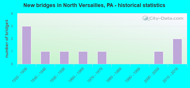
- New bridges - historical statistics
- 31930-1939
- 11940-1949
- 11950-1959
- 11960-1969
- 11970-1979
- 12000-2009
- 22010-2019

- Reconstructed bridges - Historical Statistics
- 12010-2019
- 12020-2022


- Bridge Condition - Deck
- 20.0%Very good
- 20.0%Good
- 40.0%Satisfactory
- 20.0%Fair

- Bridge Condition - Superstructure
- 20.0%Good
- 60.0%Satisfactory
- 20.0%Fair

- Bridge Condition - Substructure
- 60.0%Satisfactory
- 40.0%Fair

- Bridge Condition - Channel
- 20.0%Good
- 40.0%Satisfactory
- 20.0%Fair
- 20.0%Poor
Find on map >> Show street view
Structure Number: 5234, Location: CHRISTMAS VILLAGE ROAD (Lat: 40.417556, Lng: -76.168022), Route carried "on" structure: State highway , Year Built: 1950, Status: Open, Structure Length: 1.31m (4.30ft), Average Daily Traffic: 835 (year 2022), Truck Traffic: 7%, Average Future Daily Traffic: 820 (year 2032), Design Load: HS 20, Features Intersected: MILL CREEK, Facility Carried by Structure: SR 4010(LR 06020)
Minimum Vertical Clearance: 30+ m (98+ ft), Kilometerpoint: 3.003, Lanes on structure: 2, Owner: State Highway Agency, Approaching Roadway Width: 6.7m (22.0ft), Skew: 1 degrees, Material/Design: Steel, Design/Construction: Stringer/Multi-beam, Number Of Spans In Main Unit: 1, Length of Maximum Span: 12.5m (41.0ft), Curb-To-Curb Width: 7.3m (24.0ft), Out-to-Out Width: 8.1m (26.6ft)
Condition: Deck: Satisfactory, Superstructure: Satisfactory, Substructure: Fair, Channel: Poor, Operating Rating: 54.4 metric tons, Method Used To Determine Operating Rating: Load Factor (LF), Inventory Rating: 32.7 metric tons, Method Used To Determine Inventory Rating: Load Factor (LF), Structural Evaluation: Somewhat better than minimum adequacy, Deck Geometry: Meets minimum limits, Waterway Adequacy: Better than present minimum criteria, Approach Roadway Alignment: Equal to present desirable criteria, Length Of Structure Improvement: 2.00m (6.56ft), Designated Inspection Frequency: Every 24 months, Inspection Date: May 2021, Deck Structure Type: Concrete Cast-file-Place, Wearing Surface/Protective System: Wearing Surface: Monolithic Concrete
Find on map >> Show street view
Structure Number: 5264, Location: 3 M.S.OF SHARTLESVILLE (Lat: 40.477306, Lng: -76.106250), Route carried "on" structure: State highway , Year Built: 1962, Status: Open, Structure Length: 1.77m (5.81ft), Average Daily Traffic: 176 (year 2022), Truck Traffic: 6%, Average Future Daily Traffic: 241 (year 2032), Design Load: HS 20, Features Intersected: NORTHKILL CREEK, Facility Carried by Structure: SR 4024(LR 06178)
Minimum Vertical Clearance: 30+ m (98+ ft), Kilometerpoint: 0.000, Lanes on structure: 2, Owner: State Highway Agency, Approaching Roadway Width: 7.3m (24.0ft), Skew: 1 degrees, Material/Design: Steel, Design/Construction: Stringer/Multi-beam, Number Of Spans In Main Unit: 1, Length of Maximum Span: 17.4m (57.1ft), Curb or Sidewalk Widths: Left: 0.5m (1.6ft), Right: 0.5m (1.6ft), Curb-To-Curb Width: 9.8m (32.2ft), Out-to-Out Width: 11.4m (37.4ft)
Condition: Deck: Fair, Superstructure: Satisfactory, Substructure: Satisfactory, Channel: Fair, Operating Rating: 58.1 metric tons, Method Used To Determine Operating Rating: Load Factor (LF), Inventory Rating: 34.5 metric tons, Method Used To Determine Inventory Rating: Load Factor (LF), Structural Evaluation: Equal to present minimum criteria, Deck Geometry: Better than present minimum criteria, Waterway Adequacy: Better than present minimum criteria, Approach Roadway Alignment: Equal to present desirable criteria, Length Of Structure Improvement: 2.50m (8.20ft), Designated Inspection Frequency: Every 24 months, Inspection Date: March 2021, Deck Structure Type: Concrete Cast-file-Place, Wearing Surface/Protective System: Wearing Surface: Monolithic Concrete
Find on map >> Show street view
Structure Number: 19844, Location: 0.1 MILE SOUTH OF SR 3031 (Lat: 41.036581, Lng: -79.115503), Route carried "on" structure: City street , Year Built: 1935, Year Reconstructed: 2020, Status: Open, Structure Length: 2.23m (7.32ft), Average Daily Traffic: 100 (year 2021), Truck Traffic: 9%, Average Future Daily Traffic: 140 (year 2043), Design Load: HS 20, Features Intersected: LITTLE SANDY CREEK, Facility Carried by Structure: T-718 PINE RUN CH
Minimum Vertical Clearance: 30+ m (98+ ft), Kilometerpoint: 0.000, Lanes on structure: 2, Owner: County Highway Agency, Approaching Roadway Width: 5.5m (18.0ft), Material/Design: Prestressed concrete, Design/Construction: Box Beam or Girders - Multiple, Number Of Spans In Main Unit: 2, Length of Maximum Span: 10.7m (35.1ft), Curb or Sidewalk Widths: Left: 0.2m (0.7ft), Right: 0.2m (0.7ft), Curb-To-Curb Width: 8.0m (26.2ft), Out-to-Out Width: 9.1m (29.9ft)
Condition: Deck: Very good, Superstructure: Satisfactory, Substructure: Satisfactory, Channel: Satisfactory, Operating Rating: 90.7 metric tons, Method Used To Determine Operating Rating: Load Factor (LF), Inventory Rating: 41.7 metric tons, Method Used To Determine Inventory Rating: Load Factor (LF), Structural Evaluation: Equal to present minimum criteria, Deck Geometry: Equal to present minimum criteria, Waterway Adequacy: Equal to present minimum criteria, Approach Roadway Alignment: Equal to present desirable criteria, Length Of Structure Improvement: 2.60m (8.53ft), Designated Inspection Frequency: Every 24 months, Inspection Date: August 2021, Wearing Surface/Protective System: Wearing Surface: Integral Concrete, Deck Protection: Epoxy Coated Reinforcing
Find on map >> Show street view
Structure Number: 32033, Location: 0.7 MI NW OF ELK GROVE (Lat: 41.305697, Lng: -76.424383), Route carried "on" structure: State highway , Year Built: 1937, Status: Open, Structure Length: 0.64m (2.10ft), Average Daily Traffic: 61 (year 2017), Truck Traffic: 28%, Average Future Daily Traffic: 78 (year 2032), Features Intersected: BLOODY RUN, Facility Carried by Structure: SR 2003
Minimum Vertical Clearance: 30+ m (98+ ft), Kilometerpoint: 0.000, Lanes on structure: 2, Owner: State Highway Agency, Approaching Roadway Width: 5.2m (17.1ft), Skew: 2 degrees, Material/Design: Concrete, Design/Construction: Slab, Number Of Spans In Main Unit: 1, Length of Maximum Span: 4.9m (16.1ft), Curb or Sidewalk Widths: Left: 0.2m (0.7ft), Right: 0.2m (0.7ft), Curb-To-Curb Width: 7.0m (23.0ft), Out-to-Out Width: 7.9m (25.9ft)
Condition: Deck: Satisfactory, Superstructure: Fair, Substructure: Satisfactory, Channel: Good, Operating Rating: 54.4 metric tons, Method Used To Determine Operating Rating: Field evaluation and documented engineering judgment, Inventory Rating: 32.7 metric tons, Method Used To Determine Inventory Rating: Field evaluation and documented engineering judgment, Structural Evaluation: Somewhat better than minimum adequacy, Deck Geometry: Somewhat better than minimum adequacy, Waterway Adequacy: Better than present minimum criteria, Approach Roadway Alignment: Equal to present desirable criteria, Length Of Structure Improvement: 0.60m (1.97ft), Designated Inspection Frequency: Every 24 months, Inspection Date: December 2020, Bridge Improvement Cost: $7,000, Roadway Improvement Cost: $50,000, Total Project Cost: $90,000, Wearing Surface/Protective System: Wearing Surface: Bituminous, Membrane: Preformed Fabric
Find on map >> Show street view
Structure Number: 44007, Location: 0.1mi NE OF WALL AVE (Lat: 40.393969, Lng: -79.774944), Route carried "on" structure: State highway 48, Year Built: 2006, Status: Open, Structure Length: 0.98m (3.22ft), Average Daily Traffic: 14,804 (year 2021), Truck Traffic: 11%, Average Future Daily Traffic: 25,261 (year 2040), Design Load: HS 20, Features Intersected: Access Rd
Minimum Vertical Clearance: 30+ m (98+ ft), Kilometerpoint: 24.399, Lanes on structure: 4, Base Highway Network: Yes, Owner: State Highway Agency, Approaching Roadway Width: 7.3m (24.0ft), Skew: 20 degrees, Material/Design: Concrete, Design/Construction: Culvert, Number Of Spans In Main Unit: 1, Length of Maximum Span: 9.8m (32.2ft)
Condition: Culverts: Very good, Operating Rating: 49.0 metric tons, Method Used To Determine Operating Rating: Field evaluation and documented engineering judgment, Inventory Rating: 32.7 metric tons, Method Used To Determine Inventory Rating: Field evaluation and documented engineering judgment, Structural Evaluation: Equal to present desirable criteria, Approach Roadway Alignment: Equal to present desirable criteria, Designated Inspection Frequency: Every 24 months, Inspection Date: September 2021
Find on map >> Show street view
Structure Number: 44458, Location: S. of Westghse Ave/SR 148 (Lat: 40.361964, Lng: -79.825733), Route carried "on" structure: City street , Year Built: 1940, Year Reconstructed: 2015, Status: Open, Structure Length: 0.82m (2.69ft), Average Daily Traffic: 200 (year 2019), Truck Traffic: 5%, Average Future Daily Traffic: 205 (year 2041), Design Load: HS 20, Features Intersected: Crooked Run, Facility Carried by Structure: Osborne Street
Minimum Vertical Clearance: 30+ m (98+ ft), Kilometerpoint: 0.000, Lanes on structure: 2, Owner: Town or Township Highway Agency, Approaching Roadway Width: 6.1m (20.0ft), Material/Design: Concrete, Design/Construction: Slab, Number Of Spans In Main Unit: 1, Length of Maximum Span: 7.6m (24.9ft), Curb-To-Curb Width: 7.3m (24.0ft), Out-to-Out Width: 8.0m (26.2ft)
Condition: Deck: Good, Superstructure: Good, Substructure: Fair, Channel: Satisfactory, Inventory Rating: 76.2 metric tons, Method Used To Determine Inventory Rating: Assigned rating based on Load Factor Design (LFD) reported in metric tons, Structural Evaluation: Somewhat better than minimum adequacy, Deck Geometry: Somewhat better than minimum adequacy, Waterway Adequacy: Equal to present minimum criteria, Approach Roadway Alignment: Equal to present minimum criteria, Designated Inspection Frequency: Every 24 months, Inspection Date: July 2021, Deck Structure Type: Concrete Precast Panels, Wearing Surface/Protective System: Wearing Surface: Bituminous
Find on map >> Show street view
Structure Number: 675, Location: LR 1074 SB (Lat: 40.388111, Lng: -79.829456), Route carried "under" structure: State highway , Year Built: 1931, Structure Length: 0. m, Average Daily Traffic: 3,381 (year 2022), Truck Traffic: 6%, Features Intersected: SR 2037, Facility Carried by Structure: SR 0030 EB WB
Minimum Vertical Clearance: 5.94m (19.49ft), Kilometerpoint: 3.521, Lanes on structure: 4, Lanes under structure: 2, Material/Design: Concrete, Design/Construction: Culvert, Length of Maximum Span: 12.2m (40.0ft)
Find on map >> Show street view
Structure Number: 676, Location: RT 30 OVER SR 2037 NB (Lat: 40.387503, Lng: -79.828553), Route carried "under" structure: State highway , Year Built: 1970, Structure Length: 0. m, Average Daily Traffic: 3,514 (year 2022), Truck Traffic: 7%, Features Intersected: SR 2037 NB TRIBORO, Facility Carried by Structure: RT 0030 EB WB
Minimum Vertical Clearance: 4.70m (15.42ft), Kilometerpoint: 3.520, Lanes on structure: 4, Lanes under structure: 2, Material/Design: Prestressed concrete, Design/Construction: Box Beam or Girders - Single/Spread, Length of Maximum Span: 18.3m (60.0ft)
Find on map >> Show street view
Structure Number: 4622, Location: GREENSBURG PIKE O/ RT 30 (Lat: 40.381111, Lng: -79.816611), Route carried "under" structure: US 30, Year Built: 2010, Structure Length: 0. m, Average Daily Traffic: 9,682 (year 2022), Truck Traffic: 4%, Features Intersected: LINCOLN HIGHWAY, Facility Carried by Structure: GREENSBURG PIKE
Minimum Vertical Clearance: 6.00m (19.69ft), Kilometerpoint: 19.751, Lanes on structure: 2, Lanes under structure: 2, Material/Design: Steel, Design/Construction: Stringer/Multi-beam, Length of Maximum Span: 51.2m (168.0ft)
Find on map >> Show street view
Structure Number: 4622, Location: GREENSBURG PIKE O/ RT 30 (Lat: 40.381111, Lng: -79.816611), Route carried "under" structure: US 30, Year Built: 2010, Structure Length: 0. m, Average Daily Traffic: 7,799 (year 2022), Truck Traffic: 5%, Features Intersected: LINCOLN HIGHWAY, Facility Carried by Structure: GREENSBURG PIKE
Minimum Vertical Clearance: 5.59m (18.34ft), Kilometerpoint: 19.753, Lanes on structure: 2, Lanes under structure: 2, Material/Design: Steel, Design/Construction: Stringer/Multi-beam, Length of Maximum Span: 51.2m (168.0ft)