Bridge Statistics for McCandless Township, Pennsylvania (PA)
Condition, Traffic, Stress, Structural Evaluation, Project Costs
- National Bridge Inventory (NBI) Statistics
- 13Number of bridges
- 62ft / 19.3mTotal length
- $2,006,000Total costs
- 96,201Total average daily traffic
- 5,396Total average daily truck traffic
- National Bridge Inventory (NBI) Registered Bridges for McCandless Township
- No street view available for this location
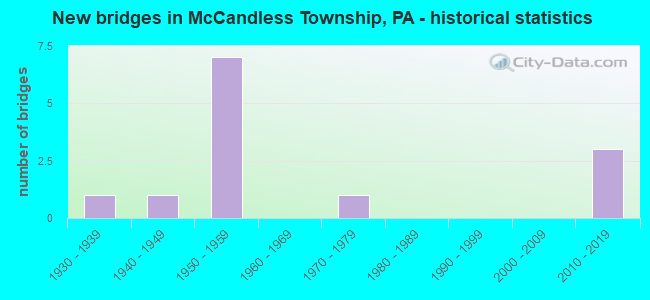
- New bridges - historical statistics
- 11930-1939
- 11940-1949
- 71950-1959
- 11970-1979
- 32010-2019


- Bridge Condition - Deck
- 40.0%Very good
- 40.0%Good
- 20.0%Satisfactory

- Bridge Condition - Superstructure
- 16.7%Very good
- 50.0%Good
- 33.3%Satisfactory

- Bridge Condition - Substructure
- 16.7%Very good
- 50.0%Good
- 16.7%Satisfactory
- 16.7%Fair

- Bridge Condition - Channel
- 57.1%Good
- 42.9%Fair

- Bridge Condition - Culverts
- 50.0%Satisfactory
- 50.0%Fair
Find on map >> Show street view
Structure Number: 539, Location: 150' SOUTH OF PINE CR.RD. (Lat: 40.585861, Lng: -80.044458), Route carried "on" structure: US 19, Year Built: 1940, Status: Open, Structure Length: 0.79m (2.59ft), Average Daily Traffic: 11,017 (year 2022), Truck Traffic: 5%, Average Future Daily Traffic: 14,985 (year 2032), Design Load: HS 20, Features Intersected: PINE CREEK
Minimum Vertical Clearance: 30+ m (98+ ft), Kilometerpoint: 34.807, Lanes on structure: 3, Owner: State Highway Agency, Approaching Roadway Width: 18.0m (59.1ft), Skew: 23 degrees, Material/Design: Concrete, Design/Construction: Culvert, Number Of Spans In Main Unit: 1, Length of Maximum Span: 7.9m (25.9ft)
Condition: Channel: Fair, Culverts: Fair, Operating Rating: 49.0 metric tons, Method Used To Determine Operating Rating: Field evaluation and documented engineering judgment, Inventory Rating: 32.7 metric tons, Method Used To Determine Inventory Rating: Field evaluation and documented engineering judgment, Structural Evaluation: Somewhat better than minimum adequacy, Waterway Adequacy: Superior to present desirable criteria, Approach Roadway Alignment: Equal to present desirable criteria, Length Of Structure Improvement: 0.80m (2.62ft), Designated Inspection Frequency: Every 24 months, Inspection Date: November 2020, Bridge Improvement Cost: $15,000, Roadway Improvement Cost: $43,000, Total Project Cost: $199,000
Find on map >> Show street view
Structure Number: 1914, Location: TRUCK RT.19 OVER SR 4070 (Lat: 40.586583, Lng: -80.040456), Route carried "on" structure: US 19T, Year Built: 1952, Year Reconstructed: 2016, Status: Open, Structure Length: 4.39m (14.40ft), Average Daily Traffic: 21,731 (year 2022), Truck Traffic: 6%, Average Future Daily Traffic: 24,242 (year 2032), Design Load: HS 20, Features Intersected: INGOMAR RD-SR 4070, Facility Carried by Structure: MCKNIGHT RD
Minimum Vertical Clearance: 30+ m (98+ ft), Kilometerpoint: 11.742, Lanes on structure: 4, Lanes under structure: 2, Base Highway Network: Yes, Owner: State Highway Agency, Approaching Roadway Width: 20.7m (67.9ft), Skew: 31 degrees, Material/Design: Steel, Design/Construction: Stringer/Multi-beam, Number Of Spans In Main Unit: 3, Length of Maximum Span: 24.1m (79.1ft), Curb or Sidewalk Widths: Left: 0.2m (0.7ft), Right: 0.2m (0.7ft), Curb-To-Curb Width: 20.7m (67.9ft), Out-to-Out Width: 21.9m (71.9ft)
Condition: Deck: Very good, Superstructure: Good, Substructure: Satisfactory, Inventory Rating: 73.5 metric tons, Method Used To Determine Inventory Rating: Load Factor (LF), Structural Evaluation: Equal to present minimum criteria, Deck Geometry: Superior to present desirable criteria, Underclear: Meets minimum limits, Approach Roadway Alignment: Equal to present desirable criteria, Length Of Structure Improvement: 4.40m (14.44ft), Designated Inspection Frequency: Every 24 months, Inspection Date: May 2020, Bridge Improvement Cost: $50,000, Roadway Improvement Cost: $147,000, Total Project Cost: $673,000, Deck Structure Type: Concrete Cast-file-Place, Wearing Surface/Protective System: Wearing Surface: Monolithic Concrete, Deck Protection: Epoxy Coated Reinforcing
Find on map >> Show street view
Structure Number: 1915, Location: 1/2 MI. N.W. OF SR 4070 (Lat: 40.589556, Lng: -80.046375), Route carried "on" structure: Spur US 19T, Year Built: 1953, Year Reconstructed: 2016, Status: Open, Structure Length: 1.95m (6.40ft), Average Daily Traffic: 21,731 (year 2022), Truck Traffic: 6%, Average Future Daily Traffic: 24,242 (year 2032), Design Load: HS 20, Features Intersected: PINE CREEK, Facility Carried by Structure: MCKNIGHT RD
Minimum Vertical Clearance: 30+ m (98+ ft), Kilometerpoint: 11.742, Lanes on structure: 4, Base Highway Network: Yes, Owner: State Highway Agency, Approaching Roadway Width: 20.1m (65.9ft), Skew: 24 degrees, Material/Design: Steel, Design/Construction: Stringer/Multi-beam, Number Of Spans In Main Unit: 1, Length of Maximum Span: 18.3m (60.0ft), Curb or Sidewalk Widths: Left: 0.2m (0.7ft), Right: 0.2m (0.7ft), Curb-To-Curb Width: 20.2m (66.3ft), Out-to-Out Width: 21.3m (69.9ft)
Condition: Deck: Very good, Superstructure: Good, Substructure: Good, Channel: Good, Operating Rating: 71.7 metric tons, Method Used To Determine Operating Rating: Load Factor (LF), Inventory Rating: 42.6 metric tons, Method Used To Determine Inventory Rating: Load Factor (LF), Structural Evaluation: Better than present minimum criteria, Deck Geometry: Better than present minimum criteria, Waterway Adequacy: Equal to present minimum criteria, Approach Roadway Alignment: Equal to present desirable criteria, Length Of Structure Improvement: 2.00m (6.56ft), Designated Inspection Frequency: Every 24 months, Inspection Date: Febuary 2020, Bridge Improvement Cost: $23,000, Roadway Improvement Cost: $68,000, Total Project Cost: $313,000, Deck Structure Type: Concrete Cast-file-Place, Wearing Surface/Protective System: Wearing Surface: Monolithic Concrete, Deck Protection: Epoxy Coated Reinforcing
Find on map >> Show street view
Structure Number: 1916, Location: 200' NORTH OF SR 4086 (Lat: 40.591528, Lng: -80.047703), Route carried "on" structure: Spur US 19T, Year Built: 1953, Year Reconstructed: 2016, Status: Open, Structure Length: 3.32m (10.89ft), Average Daily Traffic: 10,049 (year 2022), Truck Traffic: 7%, Average Future Daily Traffic: 12,023 (year 2032), Design Load: HS 20, Features Intersected: PERRY HIGHWAY-US 19, Facility Carried by Structure: MCKNIGHT RD
Minimum Vertical Clearance: 30+ m (98+ ft), Kilometerpoint: 12.925, Lanes on structure: 1, Lanes under structure: 6, Base Highway Network: Yes, Owner: State Highway Agency, Approaching Roadway Width: 9.4m (30.8ft), Skew: 4 degrees, Material/Design: Steel, Design/Construction: Stringer/Multi-beam, Number Of Spans In Main Unit: 1, Length of Maximum Span: 30.5m (100.1ft), Curb or Sidewalk Widths: Left: 0.2m (0.7ft), Right: 0.2m (0.7ft), Curb-To-Curb Width: 12.2m (40.0ft), Out-to-Out Width: 13.4m (44.0ft)
Condition: Deck: Good, Superstructure: Good, Substructure: Good, Operating Rating: 72.6 metric tons, Method Used To Determine Operating Rating: Load Factor (LF), Inventory Rating: 43.5 metric tons, Method Used To Determine Inventory Rating: Load Factor (LF), Structural Evaluation: Better than present minimum criteria, Deck Geometry: Somewhat better than minimum adequacy, Underclear: Meets minimum limits, Approach Roadway Alignment: Equal to present minimum criteria, Length Of Structure Improvement: 3.20m (10.50ft), Designated Inspection Frequency: Every 24 months, Inspection Date: May 2020, Bridge Improvement Cost: $15,000, Roadway Improvement Cost: $44,000, Total Project Cost: $201,000, Deck Structure Type: Concrete Cast-file-Place, Wearing Surface/Protective System: Wearing Surface: Integral Concrete
Find on map >> Show street view
Structure Number: 197, Location: 300' SOUTH OF SR 4070 (Lat: 40.592283, Lng: -79.996872), Route carried "on" structure: State highway , Year Built: 1936, Status: Open, Structure Length: 0.67m (2.20ft), Average Daily Traffic: 4,778 (year 2022), Truck Traffic: 6%, Average Future Daily Traffic: 7,345 (year 2032), Design Load: HS 20, Features Intersected: SMALL CREEK, DRAIN PIPE, Facility Carried by Structure: BABCOCK BL
Minimum Vertical Clearance: 30+ m (98+ ft), Kilometerpoint: 2.470, Lanes on structure: 4, Owner: State Highway Agency, Approaching Roadway Width: 12.2m (40.0ft), Material/Design: Concrete, Design/Construction: Frame, Number Of Spans In Main Unit: 1, Length of Maximum Span: 6.7m (22.0ft), Curb or Sidewalk Widths: Left: 2.7m (8.9ft), Right: 2.7m (8.9ft), Curb-To-Curb Width: 12.2m (40.0ft), Out-to-Out Width: 19.5m (64.0ft)
Condition: Superstructure: Satisfactory, Substructure: Good, Operating Rating: 49.0 metric tons, Method Used To Determine Operating Rating: Field evaluation and documented engineering judgment, Inventory Rating: 32.7 metric tons, Method Used To Determine Inventory Rating: Field evaluation and documented engineering judgment, Structural Evaluation: Equal to present minimum criteria, Deck Geometry: High priority of replacement, Waterway Adequacy: Superior to present desirable criteria, Approach Roadway Alignment: Equal to present desirable criteria, Length Of Structure Improvement: 0.70m (2.30ft), Designated Inspection Frequency: Every 24 months, Inspection Date: June 2020, Bridge Improvement Cost: $3,000, Roadway Improvement Cost: $19,000, Total Project Cost: $44,000
Find on map >> Show street view
Structure Number: 202, Location: INT ROCH RD ON SLOOP RD (Lat: 40.563694, Lng: -80.059828), Route carried "on" structure: State highway , Year Built: 1950, Status: Open, Structure Length: 0.64m (2.10ft), Average Daily Traffic: 2,538 (year 2022), Truck Traffic: 6%, Average Future Daily Traffic: 5,058 (year 2038), Design Load: HS 20, Features Intersected: LOWRIES RUN, Facility Carried by Structure: SLOOP RD
Minimum Vertical Clearance: 30+ m (98+ ft), Kilometerpoint: 0.000, Lanes on structure: 2, Owner: State Highway Agency, Approaching Roadway Width: 7.6m (24.9ft), Skew: 3 degrees, Material/Design: Concrete, Design/Construction: Slab, Number Of Spans In Main Unit: 1, Length of Maximum Span: 4.9m (16.1ft), Curb-To-Curb Width: 7.3m (24.0ft), Out-to-Out Width: 8.5m (27.9ft)
Condition: Deck: Satisfactory, Superstructure: Satisfactory, Substructure: Fair, Channel: Fair, Operating Rating: 70.8 metric tons, Method Used To Determine Operating Rating: Field evaluation and documented engineering judgment, Inventory Rating: 41.7 metric tons, Method Used To Determine Inventory Rating: Field evaluation and documented engineering judgment, Structural Evaluation: Somewhat better than minimum adequacy, Deck Geometry: High priority of replacement, Waterway Adequacy: Superior to present desirable criteria, Approach Roadway Alignment: Better than present minimum criteria, Length Of Structure Improvement: 1.20m (3.94ft), Designated Inspection Frequency: Every 24 months, Inspection Date: June 2020, Bridge Improvement Cost: $3,000, Roadway Improvement Cost: $7,000, Total Project Cost: $35,000, Deck Structure Type: Concrete Cast-file-Place, Wearing Surface/Protective System: Wearing Surface: Bituminous
Find on map >> Show street view
Structure Number: 2151, Location: 108001 OVER PINE CREEK (Lat: 40.587019, Lng: -80.022756), Route carried "on" structure: City street , Year Built: 1975, Status: Open, Structure Length: 2.44m (8.01ft), Average Daily Traffic: 2,000 (year 2021), Truck Traffic: 5%, Average Future Daily Traffic: 2,180 (year 2041), Features Intersected: PINE CREEK, Facility Carried by Structure: BLAZIER DR
Minimum Vertical Clearance: 30+ m (98+ ft), Kilometerpoint: 0.000, Lanes on structure: 3, Owner: Town or Township Highway Agency, Approaching Roadway Width: 11.0m (36.1ft), Material/Design: Steel, Design/Construction: Culvert, Number Of Spans In Main Unit: 3, Length of Maximum Span: 7.3m (24.0ft), Curb or Sidewalk Widths: Left: 3.1m (10.2ft), Right: 0.5m (1.6ft)
Condition: Channel: Fair, Culverts: Fair, Operating Rating: 54.4 metric tons, Method Used To Determine Operating Rating: Field evaluation and documented engineering judgment, Inventory Rating: 32.7 metric tons, Method Used To Determine Inventory Rating: Field evaluation and documented engineering judgment, Structural Evaluation: Somewhat better than minimum adequacy, Waterway Adequacy: Equal to present desirable criteria, Approach Roadway Alignment: Equal to present desirable criteria, Length Of Structure Improvement: 2.40m (7.87ft), Designated Inspection Frequency: Every 24 months, Inspection Date: October 2021, Bridge Improvement Cost: $40,000, Roadway Improvement Cost: $118,000, Total Project Cost: $541,000
Find on map >> Show street view
Structure Number: 4614, Location: GRUBBS ROAD (Lat: 40.591569, Lng: -80.017778), Route carried "on" structure: State highway , Year Built: 2010, Status: Open, Structure Length: 1.58m (5.18ft), Average Daily Traffic: 1,849 (year 2020), Truck Traffic: 3%, Average Future Daily Traffic: 3,333 (year 2032), Design Load: HS 20, Features Intersected: PINE CREEK, Facility Carried by Structure: GRUBBS RD
Minimum Vertical Clearance: 30+ m (98+ ft), Kilometerpoint: 0.000, Lanes on structure: 2, Owner: State Highway Agency, Approaching Roadway Width: 9.1m (29.9ft), Material/Design: Prestressed concrete, Design/Construction: Box Beam or Girders - Single/Spread, Number Of Spans In Main Unit: 1, Length of Maximum Span: 15.2m (49.9ft), Curb or Sidewalk Widths: Left: 0.2m (0.7ft), Right: 0.2m (0.7ft), Curb-To-Curb Width: 9.1m (29.9ft), Out-to-Out Width: 10.1m (33.1ft)
Condition: Deck: Good, Superstructure: Very good, Substructure: Very good, Channel: Good, Operating Rating: 83.5 metric tons, Method Used To Determine Operating Rating: Load Factor (LF), Inventory Rating: 39.9 metric tons, Method Used To Determine Inventory Rating: Load Factor (LF), Structural Evaluation: Equal to present desirable criteria, Deck Geometry: Somewhat better than minimum adequacy, Waterway Adequacy: Better than present minimum criteria, Approach Roadway Alignment: Better than present minimum criteria, Designated Inspection Frequency: Every 24 months, Inspection Date: Febuary 2020, Deck Structure Type: Concrete Cast-file-Place, Wearing Surface/Protective System: Wearing Surface: Low Slump Concrete, Deck Protection: Epoxy Coated Reinforcing
Find on map >> Show street view
Structure Number: 46151, Location: Blazier 3 over Pine Creek (Lat: 40.585853, Lng: -80.037289), Route carried "on" structure: ServiceCity street , Year Built: 2010, Status: Open, Structure Length: 1.62m (5.31ft), Average Daily Traffic: 1,500 (year 2018), Truck Traffic: 1%, Average Future Daily Traffic: 1,550 (year 2039), Design Load: HS 20, Features Intersected: Pine Creek, Facility Carried by Structure: Blazier Drive #3
Minimum Vertical Clearance: 30+ m (98+ ft), Kilometerpoint: 0.000, Lanes on structure: 2, Owner: Town or Township Highway Agency, Approaching Roadway Width: 8.5m (27.9ft), Skew: 1 degrees, Material/Design: Concrete, Design/Construction: Culvert, Number Of Spans In Main Unit: 2, Length of Maximum Span: 7.3m (24.0ft), Curb or Sidewalk Widths: Left: 0.3m (1.0ft), Right: 1.8m (5.9ft)
Condition: Channel: Good, Culverts: Satisfactory, Operating Rating: 76.2 metric tons, Method Used To Determine Operating Rating: Load Factor (LF), Inventory Rating: 48.1 metric tons, Method Used To Determine Inventory Rating: Load Factor (LF), Structural Evaluation: Equal to present minimum criteria, Waterway Adequacy: Better than present minimum criteria, Approach Roadway Alignment: Equal to present desirable criteria, Designated Inspection Frequency: Every 24 months, Inspection Date: August 2020
Find on map >> Show street view
Structure Number: 47689, Location: BLAZIER 2 OVER PINE CREEK (Lat: 40.585925, Lng: -80.035894), Route carried "on" structure: ServiceCity street , Year Built: 2012, Status: Open, Structure Length: 1.86m (6.10ft), Average Daily Traffic: 500 (year 2018), Truck Traffic: 1%, Average Future Daily Traffic: 550 (year 2039), Design Load: HS 20, Features Intersected: Pine Creek, Facility Carried by Structure: Blazier Drive #2
Minimum Vertical Clearance: 30+ m (98+ ft), Kilometerpoint: 0.000, Lanes on structure: 4, Owner: Town or Township Highway Agency, Approaching Roadway Width: 8.8m (28.9ft), Skew: 20 degrees, Material/Design: Concrete, Design/Construction: Culvert, Number Of Spans In Main Unit: 2, Length of Maximum Span: 8.5m (27.9ft), Curb or Sidewalk Widths: Left: 0.3m (1.0ft), Right: 0.2m (0.7ft)
Condition: Channel: Good, Culverts: Satisfactory, Inventory Rating: 62.6 metric tons, Method Used To Determine Inventory Rating: Assigned rating based on Load Factor Design (LFD) reported in metric tons, Structural Evaluation: Equal to present minimum criteria, Waterway Adequacy: Better than present minimum criteria, Approach Roadway Alignment: Equal to present desirable criteria, Designated Inspection Frequency: Every 24 months, Inspection Date: October 2020
Find on map >> Show street view
Structure Number: 1914, Location: TRUCK RT.19 OVER SR 4070 (Lat: 40.586583, Lng: -80.040456), Route carried "under" structure: State highway , Year Built: 1952, Structure Length: 0. m, Average Daily Traffic: 9,407 (year 2022), Truck Traffic: 5%, Features Intersected: INGOMAR RD-SR 4070, Facility Carried by Structure: MCKNIGHT RD
Minimum Vertical Clearance: 4.85m (15.91ft), Kilometerpoint: 2.593, Lanes on structure: 4, Lanes under structure: 2, Material/Design: Steel, Design/Construction: Stringer/Multi-beam, Length of Maximum Span: 24.1m (79.1ft)
Find on map >> Show street view
Structure Number: 1916, Location: 200' NORTH OF SR 4086 (Lat: 40.591528, Lng: -80.047703), Route carried "under" structure: US 19, Year Built: 1953, Structure Length: 0. m, Average Daily Traffic: 2,522 (year 2021), Truck Traffic: 5%, Features Intersected: PERRY HIGHWAY-US 19, Facility Carried by Structure: MCKNIGHT RD
Minimum Vertical Clearance: 4.44m (14.57ft), Kilometerpoint: 35.616, Lanes on structure: 1, Lanes under structure: 3, Material/Design: Steel, Design/Construction: Stringer/Multi-beam, Length of Maximum Span: 30.5m (100.1ft)
Find on map >> Show street view
Structure Number: 1916, Location: 200' NORTH OF SR 4086 (Lat: 40.591528, Lng: -80.047703), Route carried "under" structure: US 19, Year Built: 1953, Structure Length: 0. m, Average Daily Traffic: 6,579 (year 2021), Truck Traffic: 5%, Features Intersected: PERRY HIGHWAY-US 19, Facility Carried by Structure: MCKNIGHT RD
Minimum Vertical Clearance: 4.34m (14.24ft), Kilometerpoint: 35.628, Lanes on structure: 1, Lanes under structure: 3, Material/Design: Steel, Design/Construction: Stringer/Multi-beam, Length of Maximum Span: 30.5m (100.1ft)