Bridge Statistics for Mamaroneck, New York (NY)
Condition, Traffic, Stress, Structural Evaluation, Project Costs
- National Bridge Inventory (NBI) Statistics
- 35Number of bridges
- 187ft / 56.7mTotal length
- $108,546,000Total costs
- 673,566Total average daily traffic
- 45,665Total average daily truck traffic
- National Bridge Inventory (NBI) Registered Bridges for Mamaroneck
- No street view available for this location
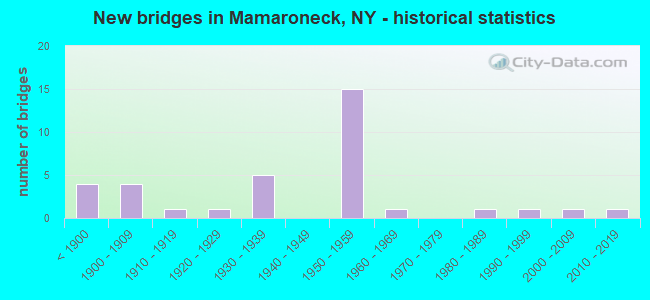
- New bridges - historical statistics
- 4Before 1900
- 41900-1909
- 11910-1919
- 11920-1929
- 51930-1939
- 151950-1959
- 11960-1969
- 11980-1989
- 11990-1999
- 12000-2009
- 12010-2019
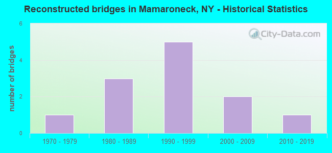
- Reconstructed bridges - Historical Statistics
- 11970-1979
- 31980-1989
- 51990-1999
- 22000-2009
- 12010-2019
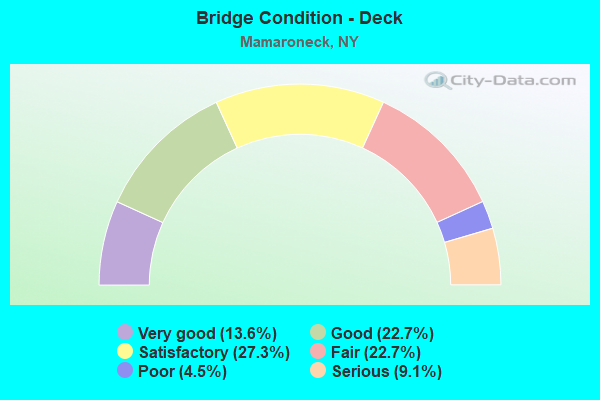
- Bridge Condition - Deck
- 13.6%Very good
- 22.7%Good
- 27.3%Satisfactory
- 22.7%Fair
- 4.5%Poor
- 9.1%Serious

- Bridge Condition - Superstructure
- 7.7%Very good
- 19.2%Good
- 23.1%Satisfactory
- 26.9%Fair
- 23.1%Poor
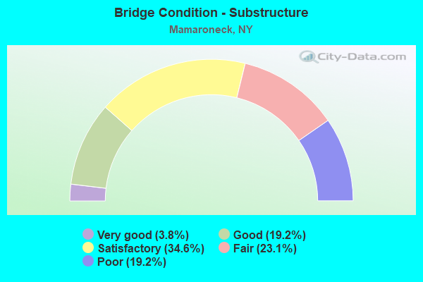
- Bridge Condition - Substructure
- 3.8%Very good
- 19.2%Good
- 34.6%Satisfactory
- 23.1%Fair
- 19.2%Poor
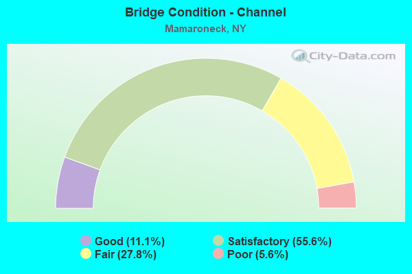
- Bridge Condition - Channel
- 11.1%Good
- 55.6%Satisfactory
- 27.8%Fair
- 5.6%Poor
Find on map >> Show street view
Structure Number: 100004, Location: JCT US 1 & MAMARONECK RVR (Lat: 40.948897, Lng: -73.732619), Route carried "on" structure: US 1, Year Built: 1895, Status: Open, Structure Length: 2.13m (6.99ft), Average Daily Traffic: 13,855 (year 2019), Truck Traffic: 1%, Average Future Daily Traffic: 13,920 (year 2040), Design Load: H 20, Features Intersected: MAMARONECK RIVER
Minimum Vertical Clearance: 30+ m (98+ ft), Kilometerpoint: 10.024, Lanes on structure: 5, Owner: State Highway Agency, Approaching Roadway Width: 16.2m (53.1ft), Skew: 3 degrees, Material/Design: Masonry, Design/Construction: Arch - Deck, Number Of Spans In Main Unit: 1, Length of Maximum Span: 15.2m (49.9ft), Curb or Sidewalk Widths: Left: 2.4m (7.9ft), Right: 0.0m, Curb-To-Curb Width: 16.2m (53.1ft), Out-to-Out Width: 20.1m (65.9ft)
Condition: Superstructure: Fair, Substructure: Fair, Operating Rating: 56.1 metric tons, Method Used To Determine Operating Rating: Field evaluation and documented engineering judgment, Inventory Rating: 20.8 metric tons, Method Used To Determine Inventory Rating: Field evaluation and documented engineering judgment, Structural Evaluation: Somewhat better than minimum adequacy, Deck Geometry: High priority of replacement, Waterway Adequacy: Equal to present minimum criteria, Approach Roadway Alignment: Meets minimum limits, Length Of Structure Improvement: 2.13m (6.99ft), Designated Inspection Frequency: Every 24 months, Inspection Date: December 2020, Bridge Improvement Cost: $3,623,000, Roadway Improvement Cost: $2,122,000, Total Project Cost: $5,745,000 ( Estimate for 2021), Wearing Surface/Protective System: Wearing Surface: Bituminous
Find on map >> Show street view
Structure Number: 222506, Location: IN MAMARONECK (Lat: 40.960325, Lng: -73.735500), Route carried "on" structure: Other road , Year Built: 1957, Status: Open, Structure Length: 1.83m (6.00ft), Average Daily Traffic: 7,329 (year 2017), Truck Traffic: 1%, Average Future Daily Traffic: 9,068 (year 2040), Design Load: HS 20+Mod, Features Intersected: MAMARONECK RIVER, Facility Carried by Structure: N BARRY AVE EXT
Minimum Vertical Clearance: 30+ m (98+ ft), Kilometerpoint: 0.129, Lanes on structure: 2, Owner: Town or Township Highway Agency, Approaching Roadway Width: 9.1m (29.9ft), Material/Design: Concrete continuous, Design/Construction: Frame, Number Of Spans In Main Unit: 3, Length of Maximum Span: 5.7m (18.7ft), Curb or Sidewalk Widths: Left: 1.6m (5.2ft), Right: 1.6m (5.2ft), Curb-To-Curb Width: 9.1m (29.9ft), Out-to-Out Width: 12.8m (42.0ft)
Condition: Deck: Fair, Superstructure: Good, Substructure: Good, Channel: Fair, Operating Rating: 25.3 metric tons, Method Used To Determine Operating Rating: Load and Resistance Factor Rating (LRFR) rating reported by rating factor(RF) method using HL-93 loadings, Inventory Rating: 19.4 metric tons, Method Used To Determine Inventory Rating: Load and Resistance Factor Rating (LRFR) rating reported by rating factor(RF) method using HL-93 loadings, Structural Evaluation: Meets minimum limits, Deck Geometry: High priority of corrective action, Waterway Adequacy: Meets minimum limits, Approach Roadway Alignment: Equal to present minimum criteria, Length Of Structure Improvement: 1.82m (5.97ft), Designated Inspection Frequency: Every 24 months, Inspection Date: June 2021, Bridge Improvement Cost: $1,669,000, Roadway Improvement Cost: $978,000, Total Project Cost: $2,647,000 ( Estimate for 2021), Deck Structure Type: Concrete Cast-file-Place, Wearing Surface/Protective System: Wearing Surface: Monolithic Concrete
Find on map >> Show street view
Structure Number: 222507, Location: AT MAMARONECK (Lat: 40.958306, Lng: -73.735203), Route carried "on" structure: Other road , Year Built: 1936, Status: Posted for load, Structure Length: 1.07m (3.51ft), Average Daily Traffic: 1,572 (year 2017), Truck Traffic: 2%, Average Future Daily Traffic: 2,201 (year 2037), Features Intersected: MAMARONECK RIVER, Facility Carried by Structure: HILLSIDE AVENUE
Minimum Vertical Clearance: 30+ m (98+ ft), Kilometerpoint: 0.354, Lanes on structure: 2, Owner: Town or Township Highway Agency, Approaching Roadway Width: 8.8m (28.9ft), Skew: 1 degrees, Material/Design: Concrete, Design/Construction: Tee Beam, Number Of Spans In Main Unit: 1, Length of Maximum Span: 10.0m (32.8ft), Curb or Sidewalk Widths: Left: 1.8m (5.9ft), Right: 1.8m (5.9ft), Curb-To-Curb Width: 9.1m (29.9ft), Out-to-Out Width: 13.9m (45.6ft)
Condition: Deck: Serious, Superstructure: Poor, Substructure: Fair, Channel: Satisfactory, Operating Rating: 29.9 metric tons, Method Used To Determine Operating Rating: Load Factor (LF), Inventory Rating: 18.1 metric tons, Method Used To Determine Inventory Rating: Load Factor (LF), Structural Evaluation: Meets minimum limits, Deck Geometry: Somewhat better than minimum adequacy, Waterway Adequacy: Equal to present desirable criteria, Approach Roadway Alignment: Equal to present desirable criteria, Bridge Posting: Required (Relationship of Operating Rating to Maximum Legal Load: > 39.9% below), Length Of Structure Improvement: 1.06m (3.48ft), Designated Inspection Frequency: Every 12 months, Inspection Date: April 2021, Bridge Improvement Cost: $542,000, Roadway Improvement Cost: $317,000, Total Project Cost: $859,000 ( Estimate for 2021), Deck Structure Type: Concrete Cast-file-Place, Wearing Surface/Protective System: Wearing Surface: Bituminous
Find on map >> Show street view
Structure Number: 222508, Location: AT MARMARONECK (Lat: 40.955783, Lng: -73.736706), Route carried "on" structure: City street , Year Built: 2013, Status: Open, Structure Length: 2.56m (8.40ft), Average Daily Traffic: 3,684 (year 2018), Truck Traffic: 2%, Average Future Daily Traffic: 5,158 (year 2038), Design Load: HL 93, Features Intersected: MAMARONECK RIVER, Facility Carried by Structure: JEFFERSON AVENUE
Minimum Vertical Clearance: 30+ m (98+ ft), Kilometerpoint: 0.193, Lanes on structure: 2, Owner: Town or Township Highway Agency, Approaching Roadway Width: 9.1m (29.9ft), Material/Design: Prestressed concrete, Design/Construction: Tee Beam, Number Of Spans In Main Unit: 1, Length of Maximum Span: 24.7m (81.0ft), Curb or Sidewalk Widths: Left: 1.8m (5.9ft), Right: 3.4m (11.2ft), Curb-To-Curb Width: 9.1m (29.9ft), Out-to-Out Width: 15.3m (50.2ft)
Condition: Deck: Good, Superstructure: Very good, Substructure: Good, Channel: Good, Operating Rating: 49.2 metric tons, Method Used To Determine Operating Rating: Load and Resistance Factor Rating (LRFR) rating reported by rating factor(RF) method using HL-93 loadings, Inventory Rating: 32.4 metric tons, Method Used To Determine Inventory Rating: Load and Resistance Factor Rating (LRFR) rating reported by rating factor(RF) method using HL-93 loadings, Structural Evaluation: Better than present minimum criteria, Deck Geometry: Meets minimum limits, Waterway Adequacy: Equal to present minimum criteria, Approach Roadway Alignment: Equal to present desirable criteria, Length Of Structure Improvement: 2.56m (8.40ft), Designated Inspection Frequency: Every 24 months, Inspection Date: November 2020, Bridge Improvement Cost: $1,487,000, Roadway Improvement Cost: $871,000, Total Project Cost: $2,358,000 ( Estimate for 2021), Wearing Surface/Protective System: Wearing Surface: Monolithic Concrete
Find on map >> Show street view
Structure Number: 222509, Location: AT MAMARONECK (Lat: 40.953431, Lng: -73.738114), Route carried "on" structure: County highway , Year Built: 2005, Status: Open, Structure Length: 0.91m (2.99ft), Average Daily Traffic: 15,876 (year 2016), Truck Traffic: 4%, Average Future Daily Traffic: 15,950 (year 2040), Features Intersected: SHELDRAKE RIVER, Facility Carried by Structure: MAMARONECK AVENUE
Minimum Vertical Clearance: 30+ m (98+ ft), Kilometerpoint: 0.113, Lanes on structure: 4, Owner: County Highway Agency, Approaching Roadway Width: 18.0m (59.1ft), Material/Design: Concrete, Design/Construction: Arch - Deck, Number Of Spans In Main Unit: 1, Length of Maximum Span: 8.5m (27.9ft), Curb or Sidewalk Widths: Left: 5.8m (19.0ft), Right: 6.2m (20.3ft), Curb-To-Curb Width: 18.0m (59.1ft), Out-to-Out Width: 31.6m (103.7ft)
Condition: Superstructure: Very good, Substructure: Very good, Channel: Good, Operating Rating: 98.0 metric tons, Method Used To Determine Operating Rating: Load Factor (LF), Inventory Rating: 59.0 metric tons, Method Used To Determine Inventory Rating: Load Factor (LF), Structural Evaluation: Equal to present desirable criteria, Deck Geometry: Somewhat better than minimum adequacy, Waterway Adequacy: Equal to present minimum criteria, Approach Roadway Alignment: Equal to present desirable criteria, Length Of Structure Improvement: 0.91m (2.99ft), Designated Inspection Frequency: Every 24 months, Inspection Date: July 2020, Bridge Improvement Cost: $1,654,000, Roadway Improvement Cost: $969,000, Total Project Cost: $2,623,000 ( Estimate for 2021), Wearing Surface/Protective System: Wearing Surface: Bituminous
Find on map >> Show street view
Structure Number: 22251, Location: 3 MI W OF HUTCHINSON PKWY (Lat: 40.954844, Lng: -73.735792), Route carried "on" structure: Other road , Year Built: 1987, Status: Posted for load, Structure Length: 2.56m (8.40ft), Average Daily Traffic: 1,504 (year 2017), Truck Traffic: 4%, Average Future Daily Traffic: 2,106 (year 2037), Design Load: HS 20, Features Intersected: MAMARONECK RIVER, Facility Carried by Structure: STATION PLAZA
Minimum Vertical Clearance: 30+ m (98+ ft), Kilometerpoint: 0.225, Lanes on structure: 2, Owner: Town or Township Highway Agency, Approaching Roadway Width: 9.1m (29.9ft), Skew: 3 degrees, Material/Design: Prestressed concrete, Design/Construction: Box Beam or Girders - Multiple, Number Of Spans In Main Unit: 2, Length of Maximum Span: 9.7m (31.8ft), Curb or Sidewalk Widths: Left: 2.4m (7.9ft), Right: 2.4m (7.9ft), Curb-To-Curb Width: 9.2m (30.2ft), Out-to-Out Width: 14.6m (47.9ft)
Condition: Deck: Satisfactory, Superstructure: Satisfactory, Substructure: Fair, Channel: Poor, Operating Rating: 28.2 metric tons, Method Used To Determine Operating Rating: Load and Resistance Factor Rating (LRFR) rating reported by rating factor(RF) method using HL-93 loadings, Inventory Rating: 20.7 metric tons, Method Used To Determine Inventory Rating: Load and Resistance Factor Rating (LRFR) rating reported by rating factor(RF) method using HL-93 loadings, Structural Evaluation: Somewhat better than minimum adequacy, Deck Geometry: Somewhat better than minimum adequacy, Waterway Adequacy: Equal to present desirable criteria, Approach Roadway Alignment: Equal to present desirable criteria, Bridge Posting: Required (Relationship of Operating Rating to Maximum Legal Load: > 39.9% below), Length Of Structure Improvement: 2.56m (8.40ft), Designated Inspection Frequency: Every 12 months, Inspection Date: April 2021, Bridge Improvement Cost: $1,532,000, Roadway Improvement Cost: $897,000, Total Project Cost: $2,430,000 ( Estimate for 2021), Wearing Surface/Protective System: Wearing Surface: Bituminous, Membrane: Other
Find on map >> Show street view
Structure Number: 222511, Location: AT MAMARONECK (Lat: 40.952350, Lng: -73.734497), Route carried "on" structure: Other road , Year Built: 1937, Status: Open, Structure Length: 1.04m (3.41ft), Average Daily Traffic: 320 (year 2018), Truck Traffic: 2%, Average Future Daily Traffic: 448 (year 2038), Features Intersected: MAMARONECK RIVER, Facility Carried by Structure: WARD AVENUE
Minimum Vertical Clearance: 30+ m (98+ ft), Kilometerpoint: 0.193, Lanes on structure: 2, Owner: Town or Township Highway Agency, Approaching Roadway Width: 9.8m (32.2ft), Material/Design: Concrete, Design/Construction: Arch - Deck, Number Of Spans In Main Unit: 1, Length of Maximum Span: 9.4m (30.8ft), Curb or Sidewalk Widths: Left: 2.8m (9.2ft), Right: 2.7m (8.9ft), Curb-To-Curb Width: 9.8m (32.2ft), Out-to-Out Width: 16.3m (53.5ft)
Condition: Superstructure: Fair, Substructure: Fair, Channel: Fair, Operating Rating: 65.2 metric tons, Method Used To Determine Operating Rating: Field evaluation and documented engineering judgment, Inventory Rating: 25.3 metric tons, Method Used To Determine Inventory Rating: Field evaluation and documented engineering judgment, Structural Evaluation: Somewhat better than minimum adequacy, Deck Geometry: Better than present minimum criteria, Waterway Adequacy: Meets minimum limits, Approach Roadway Alignment: Equal to present minimum criteria, Length Of Structure Improvement: 1.03m (3.38ft), Designated Inspection Frequency: Every 24 months, Inspection Date: March 2021, Bridge Improvement Cost: $1,126,000, Roadway Improvement Cost: $659,000, Total Project Cost: $1,785,000 ( Estimate for 2021), Wearing Surface/Protective System: Wearing Surface: Bituminous
Find on map >> Show street view
Structure Number: 222512, Location: AT MAMARONECK (Lat: 40.950833, Lng: -73.732333), Route carried "on" structure: Other road , Year Built: 1900, Status: Posted for load, Structure Length: 1.07m (3.51ft), Average Daily Traffic: 2,803 (year 2016), Truck Traffic: 4%, Average Future Daily Traffic: 3,924 (year 2036), Features Intersected: MAMARONECK RIVER, Facility Carried by Structure: TOMPKINS AVE
Minimum Vertical Clearance: 30+ m (98+ ft), Kilometerpoint: 0.483, Lanes on structure: 2, Owner: Town or Township Highway Agency, Approaching Roadway Width: 9.1m (29.9ft), Material/Design: Steel, Design/Construction: Stringer/Multi-beam, Number Of Spans In Main Unit: 1, Length of Maximum Span: 9.8m (32.2ft), Curb or Sidewalk Widths: Left: 3.0m (9.8ft), Right: 3.0m (9.8ft), Curb-To-Curb Width: 9.1m (29.9ft), Out-to-Out Width: 15.5m (50.9ft)
Condition: Deck: Serious, Superstructure: Poor, Substructure: Poor, Channel: Fair, Operating Rating: 22.7 metric tons, Method Used To Determine Operating Rating: Load Factor (LF), Inventory Rating: 13.6 metric tons, Method Used To Determine Inventory Rating: Load Factor (LF), Structural Evaluation: Meets minimum limits, Deck Geometry: Meets minimum limits, Waterway Adequacy: Meets minimum limits, Approach Roadway Alignment: Better than present minimum criteria, Bridge Posting: Required (Relationship of Operating Rating to Maximum Legal Load: > 39.9% below), Length Of Structure Improvement: 1.06m (3.48ft), Designated Inspection Frequency: Every 12 months, Underwater Inspection Frequency: Every 60 months, Inspection Date: June 2021, Underwater Inspection Date: May 2021, Bridge Improvement Cost: $1,345,000, Roadway Improvement Cost: $787,000, Total Project Cost: $2,132,000 ( Estimate for 2021), Deck Structure Type: Concrete Cast-file-Place, Wearing Surface/Protective System: Wearing Surface: Bituminous
Find on map >> Show street view
Structure Number: 222514, Location: AT MAMARONECK (Lat: 40.951575, Lng: -73.741128), Route carried "on" structure: Other road , Year Built: 1931, Year Reconstructed: 2003, Status: Posted for load, Structure Length: 1.01m (3.31ft), Average Daily Traffic: 8,859 (year 2016), Truck Traffic: 4%, Average Future Daily Traffic: 12,403 (year 2036), Features Intersected: SHELDRAKE RIVER, Facility Carried by Structure: WAVERLY AVENUE
Minimum Vertical Clearance: 30+ m (98+ ft), Kilometerpoint: 0.338, Lanes on structure: 2, Owner: Town or Township Highway Agency, Approaching Roadway Width: 6.4m (21.0ft), Skew: 2 degrees, Material/Design: Steel, Design/Construction: Stringer/Multi-beam, Number Of Spans In Main Unit: 1, Length of Maximum Span: 8.8m (28.9ft), Curb-To-Curb Width: 8.5m (27.9ft), Out-to-Out Width: 9.0m (29.5ft)
Condition: Deck: Poor, Superstructure: Poor, Substructure: Poor, Channel: Fair, Operating Rating: 4.2 metric tons, Method Used To Determine Operating Rating: Load and Resistance Factor Rating (LRFR) rating reported by rating factor(RF) method using HL-93 loadings, Inventory Rating: 3.2 metric tons, Method Used To Determine Inventory Rating: Load and Resistance Factor Rating (LRFR) rating reported by rating factor(RF) method using HL-93 loadings, Structural Evaluation: High priority of corrective action, Deck Geometry: High priority of replacement, Waterway Adequacy: Equal to present desirable criteria, Approach Roadway Alignment: Somewhat better than minimum adequacy, Bridge Posting: Required (Relationship of Operating Rating to Maximum Legal Load: > 39.9% below), Length Of Structure Improvement: 1.00m (3.28ft), Designated Inspection Frequency: Every 12 months, Inspection Date: March 2021, Bridge Improvement Cost: $518,000, Roadway Improvement Cost: $303,000, Total Project Cost: $822,000 ( Estimate for 2021), Deck Structure Type: Concrete Cast-file-Place, Wearing Surface/Protective System: Wearing Surface: Bituminous
Find on map >> Show street view
Structure Number: 226228, Location: 0.9 MI W OF MAMARONECK (Lat: 40.943892, Lng: -73.753342), Route carried "on" structure: Other road , Year Built: 1939, Status: Open, Structure Length: 0.88m (2.89ft), Average Daily Traffic: 159 (year 2020), Truck Traffic: 2%, Average Future Daily Traffic: 223 (year 2040), Design Load: H 20, Features Intersected: SHELDRAKE RIVER, Facility Carried by Structure: HICKORY GROVE DRV
Minimum Vertical Clearance: 30+ m (98+ ft), Kilometerpoint: 0.563, Lanes on structure: 2, Owner: Town or Township Highway Agency, Approaching Roadway Width: 9.1m (29.9ft), Material/Design: Steel, Design/Construction: Stringer/Multi-beam, Number Of Spans In Main Unit: 1, Length of Maximum Span: 8.5m (27.9ft), Curb or Sidewalk Widths: Left: 0.8m (2.6ft), Right: 2.7m (8.9ft), Curb-To-Curb Width: 9.0m (29.5ft), Out-to-Out Width: 12.5m (41.0ft)
Condition: Deck: Fair, Superstructure: Fair, Substructure: Satisfactory, Channel: Satisfactory, Operating Rating: 57.7 metric tons, Method Used To Determine Operating Rating: Load and Resistance Factor Rating (LRFR) rating reported by rating factor(RF) method using HL-93 loadings, Inventory Rating: 44.4 metric tons, Method Used To Determine Inventory Rating: Load and Resistance Factor Rating (LRFR) rating reported by rating factor(RF) method using HL-93 loadings, Structural Evaluation: Somewhat better than minimum adequacy, Deck Geometry: Equal to present minimum criteria, Waterway Adequacy: Meets minimum limits, Approach Roadway Alignment: Equal to present minimum criteria, Length Of Structure Improvement: 0.88m (2.89ft), Designated Inspection Frequency: Every 24 months, Inspection Date: March 2021, Bridge Improvement Cost: $957,000, Roadway Improvement Cost: $560,000, Total Project Cost: $1,517,000 ( Estimate for 2021), Deck Structure Type: Concrete Cast-file-Place, Wearing Surface/Protective System: Wearing Surface: Bituminous
Find on map >> Show street view
Structure Number: 226514, Location: AT MAMARONECK (Lat: 40.951628, Lng: -73.745081), Route carried "on" structure: Other road , Year Built: 1956, Year Reconstructed: 2003, Status: Open, Structure Length: 1.22m (4.00ft), Average Daily Traffic: 11,125 (year 2019), Truck Traffic: 4%, Average Future Daily Traffic: 13,764 (year 2040), Features Intersected: SHELDRAKE RIVER, Facility Carried by Structure: FENIMORE ROAD
Minimum Vertical Clearance: 30+ m (98+ ft), Kilometerpoint: 0.145, Lanes on structure: 2, Owner: Town or Township Highway Agency, Approaching Roadway Width: 11.0m (36.1ft), Material/Design: Concrete, Design/Construction: Frame, Number Of Spans In Main Unit: 2, Length of Maximum Span: 5.4m (17.7ft), Curb or Sidewalk Widths: Left: 0.9m (3.0ft), Right: 0.9m (3.0ft), Curb-To-Curb Width: 11.0m (36.1ft), Out-to-Out Width: 13.1m (43.0ft)
Condition: Deck: Satisfactory, Superstructure: Good, Substructure: Satisfactory, Channel: Satisfactory, Operating Rating: 60.9 metric tons, Method Used To Determine Operating Rating: Load and Resistance Factor Rating (LRFR) rating reported by rating factor(RF) method using HL-93 loadings, Inventory Rating: 47.0 metric tons, Method Used To Determine Inventory Rating: Load and Resistance Factor Rating (LRFR) rating reported by rating factor(RF) method using HL-93 loadings, Structural Evaluation: Equal to present minimum criteria, Deck Geometry: Meets minimum limits, Waterway Adequacy: Somewhat better than minimum adequacy, Approach Roadway Alignment: Equal to present desirable criteria, Length Of Structure Improvement: 1.21m (3.97ft), Designated Inspection Frequency: Every 24 months, Inspection Date: May 2021, Bridge Improvement Cost: $1,035,000, Roadway Improvement Cost: $606,000, Total Project Cost: $1,642,000 ( Estimate for 2021), Wearing Surface/Protective System: Wearing Surface: Bituminous
Find on map >> Show street view
Structure Number: 226517, Location: AT MAMARONECK/ RYE (Lat: 40.958597, Lng: -73.730908), Route carried "on" structure: Other road , Year Built: 1887, Year Reconstructed: 1982, Status: Posted for load, Structure Length: 1.98m (6.50ft), Average Daily Traffic: 7,329 (year 2017), Truck Traffic: 1%, Average Future Daily Traffic: 9,068 (year 2040), Features Intersected: MNRR NH LINE, Facility Carried by Structure: NO. BARRY AVENUE
Minimum Vertical Clearance: 30+ m (98+ ft), Kilometerpoint: 0.708, Lanes on structure: 2, Owner: Railroad, Approaching Roadway Width: 8.8m (28.9ft), Skew: 1 degrees, Material/Design: Steel, Design/Construction: Truss - Thru, Number Of Spans In Main Unit: 1, Number Of Approach Spans: 1, Length of Maximum Span: 17.3m (56.8ft), Curb or Sidewalk Widths: Left: 1.2m (3.9ft), Right: 2.6m (8.5ft), Curb-To-Curb Width: 9.1m (29.9ft), Out-to-Out Width: 15.5m (50.9ft)
Condition: Deck: Satisfactory, Superstructure: Poor, Substructure: Poor, Operating Rating: 14.5 metric tons, Method Used To Determine Operating Rating: Allowable Stress (AS), Inventory Rating: 10.0 metric tons, Method Used To Determine Inventory Rating: Allowable Stress (AS), Structural Evaluation: High priority of corrective action, Deck Geometry: High priority of corrective action, Underclear: High priority of corrective action, Approach Roadway Alignment: Equal to present desirable criteria, Bridge Posting: Required (Relationship of Operating Rating to Maximum Legal Load: > 39.9% below), Length Of Structure Improvement: 1.98m (6.50ft), Designated Inspection Frequency: Every 12 months, Critical Feature Inspection Frequency: Every 12 months, Inspection Date: December 2021, Critical Feature Inspection Date: December 2021, Bridge Improvement Cost: $4,501,000, Roadway Improvement Cost: $2,636,000, Total Project Cost: $7,136,000 ( Estimate for 2021), Deck Structure Type: Wood or Timber, Wearing Surface/Protective System: Wearing Surface: Bituminous
Find on map >> Show street view
Structure Number: 226525, Location: AT MAMARONECK RYE (Lat: 40.956803, Lng: -73.732958), Route carried "on" structure: Other road , Year Built: 1887, Year Reconstructed: 2015, Status: Posted for load, Structure Length: 1.92m (6.30ft), Average Daily Traffic: 1,572 (year 2017), Truck Traffic: 2%, Average Future Daily Traffic: 2,201 (year 2037), Features Intersected: MNRR NH LINE, Facility Carried by Structure: HILLSIDE AVENUE
Minimum Vertical Clearance: 30+ m (98+ ft), Kilometerpoint: 0.064, Lanes on structure: 2, Owner: Railroad, Maintenance Responsibility: Town or Township Highway Agency, Approaching Roadway Width: 9.4m (30.8ft), Material/Design: Steel, Design/Construction: Truss - Thru, Number Of Spans In Main Unit: 1, Number Of Approach Spans: 1, Length of Maximum Span: 17.1m (56.1ft), Curb or Sidewalk Widths: Left: 2.5m (8.2ft), Right: 2.5m (8.2ft), Curb-To-Curb Width: 9.4m (30.8ft), Out-to-Out Width: 15.1m (49.5ft)
Condition: Deck: Very good, Superstructure: Poor, Substructure: Poor, Operating Rating: 13.6 metric tons, Method Used To Determine Operating Rating: Load Factor (LF), Inventory Rating: 7.3 metric tons, Method Used To Determine Inventory Rating: Load Factor (LF), Structural Evaluation: High priority of corrective action, Deck Geometry: Somewhat better than minimum adequacy, Underclear: High priority of corrective action, Approach Roadway Alignment: Equal to present desirable criteria, Bridge Posting: Required (Relationship of Operating Rating to Maximum Legal Load: > 39.9% below), Length Of Structure Improvement: 1.92m (6.30ft), Designated Inspection Frequency: Every 12 months, Critical Feature Inspection Frequency: Every 12 months, Inspection Date: December 2021, Critical Feature Inspection Date: December 2021, Bridge Improvement Cost: $4,310,000, Roadway Improvement Cost: $2,524,000, Total Project Cost: $6,833,000 ( Estimate for 2021), Deck Structure Type: Wood or Timber, Wearing Surface/Protective System: Wearing Surface: Bituminous
Find on map >> Show street view
Structure Number: 226526, Location: AT MAMARONECK (Lat: 40.947211, Lng: -73.747472), Route carried "on" structure: Other road , Year Built: 1955, Status: Open, Structure Length: 1.37m (4.49ft), Average Daily Traffic: 3,726 (year 2017), Truck Traffic: 4%, Average Future Daily Traffic: 4,610 (year 2040), Features Intersected: SHELDRAKE RIVER, Facility Carried by Structure: ROCKLAND AVENUE
Minimum Vertical Clearance: 30+ m (98+ ft), Kilometerpoint: 0.949, Lanes on structure: 2, Owner: Town or Township Highway Agency, Approaching Roadway Width: 9.4m (30.8ft), Material/Design: Concrete, Design/Construction: Culvert, Number Of Spans In Main Unit: 2, Length of Maximum Span: 5.4m (17.7ft)
Condition: Channel: Satisfactory, Culverts: Satisfactory, Operating Rating: 97.2 metric tons, Method Used To Determine Operating Rating: Load and Resistance Factor Rating (LRFR) rating reported by rating factor(RF) method using HL-93 loadings, Inventory Rating: 97.2 metric tons, Method Used To Determine Inventory Rating: Load and Resistance Factor Rating (LRFR) rating reported by rating factor(RF) method using HL-93 loadings, Structural Evaluation: Equal to present minimum criteria, Waterway Adequacy: Meets minimum limits, Approach Roadway Alignment: Equal to present desirable criteria, Length Of Structure Improvement: 1.37m (4.49ft), Designated Inspection Frequency: Every 24 months, Inspection Date: June 2021, Bridge Improvement Cost: $365,000, Roadway Improvement Cost: $214,000, Total Project Cost: $579,000 ( Estimate for 2021)
Find on map >> Show street view
Structure Number: 226578, Location: AT MAMARONECK / RYE (Lat: 40.949286, Lng: -73.725331), Route carried "on" structure: Other road , Year Built: 1992, Status: Open, Structure Length: 1.19m (3.90ft), Average Daily Traffic: 1,464 (year 2015), Truck Traffic: 2%, Average Future Daily Traffic: 1,811 (year 2040), Design Load: HS 20, Features Intersected: BEAVER SWAMP BRK, Facility Carried by Structure: SOUTH BARRY AVE
Minimum Vertical Clearance: 30+ m (98+ ft), Kilometerpoint: 0.579, Lanes on structure: 2, Owner: Town or Township Highway Agency, Approaching Roadway Width: 9.1m (29.9ft), Material/Design: Prestressed concrete, Design/Construction: Box Beam or Girders - Multiple, Number Of Spans In Main Unit: 1, Length of Maximum Span: 11.0m (36.1ft), Curb or Sidewalk Widths: Left: 2.6m (8.5ft), Right: 1.8m (5.9ft), Curb-To-Curb Width: 9.1m (29.9ft), Out-to-Out Width: 13.6m (44.6ft)
Condition: Deck: Good, Superstructure: Good, Substructure: Good, Channel: Fair, Operating Rating: 69.9 metric tons, Method Used To Determine Operating Rating: Allowable Stress (AS), Inventory Rating: 32.7 metric tons, Method Used To Determine Inventory Rating: Allowable Stress (AS), Structural Evaluation: Better than present minimum criteria, Deck Geometry: Somewhat better than minimum adequacy, Waterway Adequacy: Somewhat better than minimum adequacy, Approach Roadway Alignment: Equal to present desirable criteria, Length Of Structure Improvement: 1.18m (3.87ft), Designated Inspection Frequency: Every 24 months, Inspection Date: June 2021, Bridge Improvement Cost: $846,000, Roadway Improvement Cost: $496,000, Total Project Cost: $1,342,000 ( Estimate for 2021), Wearing Surface/Protective System: Wearing Surface: Bituminous
Find on map >> Show street view
Structure Number: 226579, Location: IN MAMARONECK/SHORE ACRES (Lat: 40.944508, Lng: -73.723358), Route carried "on" structure: Other road , Year Built: 1930, Year Reconstructed: 2003, Status: Open, Structure Length: 1.01m (3.31ft), Average Daily Traffic: 87 (year 2019), Truck Traffic: 6%, Average Future Daily Traffic: 122 (year 2039), Features Intersected: OTTER CREEK TIDAL BASIN, Facility Carried by Structure: SOUTH BARRY AVE
Minimum Vertical Clearance: 30+ m (98+ ft), Kilometerpoint: 0.016, Lanes on structure: 2, Owner: Town or Township Highway Agency, Approaching Roadway Width: 7.6m (24.9ft), Material/Design: Steel, Design/Construction: Stringer/Multi-beam, Number Of Spans In Main Unit: 1, Length of Maximum Span: 9.8m (32.2ft), Curb or Sidewalk Widths: Left: 0.0m, Right: 1.5m (4.9ft), Curb-To-Curb Width: 5.5m (18.0ft), Out-to-Out Width: 7.5m (24.6ft)
Condition: Deck: Fair, Superstructure: Fair, Substructure: Fair, Channel: Satisfactory, Operating Rating: 48.3 metric tons, Method Used To Determine Operating Rating: Load and Resistance Factor Rating (LRFR) rating reported by rating factor(RF) method using HL-93 loadings, Inventory Rating: 37.3 metric tons, Method Used To Determine Inventory Rating: Load and Resistance Factor Rating (LRFR) rating reported by rating factor(RF) method using HL-93 loadings, Structural Evaluation: Somewhat better than minimum adequacy, Deck Geometry: Meets minimum limits, Waterway Adequacy: Equal to present desirable criteria, Approach Roadway Alignment: Meets minimum limits, Length Of Structure Improvement: 1.00m (3.28ft), Designated Inspection Frequency: Every 24 months, Inspection Date: April 2020, Bridge Improvement Cost: $445,000, Roadway Improvement Cost: $261,000, Total Project Cost: $706,000 ( Estimate for 2021), Deck Structure Type: Concrete Cast-file-Place, Wearing Surface/Protective System: Wearing Surface: Bituminous, Deck Protection: Epoxy Coated Reinforcing
Find on map >> Show street view
Structure Number: 3347919, Location: 1.4 MI NW MAMARONECK RYE (Lat: 40.968403, Lng: -73.741453), Route carried "on" structure: County highway , Year Built: 1963, Status: Open, Structure Length: 1.62m (5.31ft), Average Daily Traffic: 21,846 (year 2008), Truck Traffic: 6%, Average Future Daily Traffic: 21,948 (year 2040), Features Intersected: MAMARONECK RIVER, Facility Carried by Structure: MAMARONECK AVENUE
Minimum Vertical Clearance: 30+ m (98+ ft), Kilometerpoint: 2.220, Lanes on structure: 4, Owner: County Highway Agency, Approaching Roadway Width: 22.6m (74.1ft), Skew: 30 degrees, Material/Design: Prestressed concrete, Design/Construction: Box Beam or Girders - Multiple, Number Of Spans In Main Unit: 1, Length of Maximum Span: 15.2m (49.9ft), Curb or Sidewalk Widths: Left: 1.2m (3.9ft), Right: 1.2m (3.9ft), Curb-To-Curb Width: 17.9m (58.7ft), Out-to-Out Width: 25.6m (84.0ft)
Condition: Deck: Satisfactory, Superstructure: Fair, Substructure: Satisfactory, Channel: Satisfactory, Operating Rating: 48.0 metric tons, Method Used To Determine Operating Rating: Load and Resistance Factor Rating (LRFR) rating reported by rating factor(RF) method using HL-93 loadings, Inventory Rating: 16.8 metric tons, Method Used To Determine Inventory Rating: Load and Resistance Factor Rating (LRFR) rating reported by rating factor(RF) method using HL-93 loadings, Structural Evaluation: Meets minimum limits, Deck Geometry: Somewhat better than minimum adequacy, Waterway Adequacy: Somewhat better than minimum adequacy, Approach Roadway Alignment: Equal to present desirable criteria, Length Of Structure Improvement: 1.61m (5.28ft), Designated Inspection Frequency: Every 24 months, Inspection Date: March 2021, Bridge Improvement Cost: $1,900,000, Roadway Improvement Cost: $1,113,000, Total Project Cost: $3,013,000 ( Estimate for 2021), Wearing Surface/Protective System: Wearing Surface: Bituminous
Find on map >> Show street view
Structure Number: 334829, Location: AT MAMARONECK (Lat: 40.954614, Lng: -73.734989), Route carried "on" structure: Other road , Year Built: 1910, Year Reconstructed: 2003, Status: Open, Structure Length: 1.46m (4.79ft), Average Daily Traffic: 6,767 (year 2017), Truck Traffic: 3%, Average Future Daily Traffic: 8,220 (year 2040), Features Intersected: MAMARONECK RIVER, Facility Carried by Structure: HALSTEAD AVENUE
Minimum Vertical Clearance: 30+ m (98+ ft), Kilometerpoint: 1.255, Lanes on structure: 2, Owner: County Highway Agency, Approaching Roadway Width: 11.9m (39.0ft), Material/Design: Steel, Design/Construction: Stringer/Multi-beam, Number Of Spans In Main Unit: 1, Length of Maximum Span: 13.4m (44.0ft), Curb or Sidewalk Widths: Left: 3.0m (9.8ft), Right: 4.0m (13.1ft), Curb-To-Curb Width: 12.9m (42.3ft), Out-to-Out Width: 21.0m (68.9ft)
Condition: Deck: Fair, Superstructure: Satisfactory, Substructure: Satisfactory, Channel: Satisfactory, Inventory Rating: 84.4 metric tons, Method Used To Determine Inventory Rating: Load Factor (LF), Structural Evaluation: Equal to present minimum criteria, Deck Geometry: Somewhat better than minimum adequacy, Waterway Adequacy: Meets minimum limits, Approach Roadway Alignment: Equal to present desirable criteria, Length Of Structure Improvement: 1.46m (4.79ft), Designated Inspection Frequency: Every 24 months, Inspection Date: April 2020, Bridge Improvement Cost: $2,457,000, Roadway Improvement Cost: $1,439,000, Total Project Cost: $3,896,000 ( Estimate for 2021), Deck Structure Type: Concrete Cast-file-Place, Wearing Surface/Protective System: Wearing Surface: Bituminous
Find on map >> Show street view
Structure Number: 334848, Location: 0.8 MI W OF MAMARONECK (Lat: 40.943478, Lng: -73.752150), Route carried "on" structure: Other road , Year Built: 1925, Year Reconstructed: 1994, Status: Open, Structure Length: 1.04m (3.41ft), Average Daily Traffic: 1,418 (year 2018), Truck Traffic: 4%, Average Future Daily Traffic: 1,985 (year 2038), Design Load: HS 25 or greater, Features Intersected: SHELDRAKE RIVER, Facility Carried by Structure: LAKESIDE DRIVE
Minimum Vertical Clearance: 30+ m (98+ ft), Kilometerpoint: 0.016, Lanes on structure: 2, Owner: County Highway Agency, Approaching Roadway Width: 8.8m (28.9ft), Material/Design: Prestressed concrete, Design/Construction: Box Beam or Girders - Multiple, Number Of Spans In Main Unit: 1, Length of Maximum Span: 8.8m (28.9ft), Curb or Sidewalk Widths: Left: 1.5m (4.9ft), Right: 0.0m, Curb-To-Curb Width: 8.8m (28.9ft), Out-to-Out Width: 11.9m (39.0ft)
Condition: Deck: Good, Superstructure: Good, Substructure: Good, Channel: Satisfactory, Operating Rating: 41.5 metric tons, Method Used To Determine Operating Rating: Load and Resistance Factor Rating (LRFR) rating reported by rating factor(RF) method using HL-93 loadings, Inventory Rating: 31.8 metric tons, Method Used To Determine Inventory Rating: Load and Resistance Factor Rating (LRFR) rating reported by rating factor(RF) method using HL-93 loadings, Structural Evaluation: Better than present minimum criteria, Deck Geometry: Somewhat better than minimum adequacy, Waterway Adequacy: Equal to present minimum criteria, Approach Roadway Alignment: Better than present minimum criteria, Length Of Structure Improvement: 1.03m (3.38ft), Designated Inspection Frequency: Every 24 months, Inspection Date: May 2021, Bridge Improvement Cost: $298,000, Roadway Improvement Cost: $175,000, Total Project Cost: $473,000 ( Estimate for 2021), Wearing Surface/Protective System: Wearing Surface: Bituminous, Membrane: Other
Find on map >> Show street view
Structure Number: 5514649, Location: 2.8 MI SW JCT RTS I95<127 (Lat: 40.945367, Lng: -73.749747), Route carried "on" structure: Interstate 95, Year Built: 1956, Status: Open, Structure Length: 1.68m (5.51ft), Truck Traffic: 15%, Design Load: HS 20+Mod, Features Intersected: SHELDRAKE RIVER
Minimum Vertical Clearance: 30+ m (98+ ft), Kilometerpoint: 8.190, Lanes on structure: 6, Base Highway Network: Yes, Toll: On Interstate toll segment, Owner: State Toll Authority, Approaching Roadway Width: 30.1m (98.8ft), Skew: 24 degrees, Material/Design: Concrete, Design/Construction: Frame, Number Of Spans In Main Unit: 2, Length of Maximum Span: 8.2m (26.9ft), Curb-To-Curb Width: 30.1m (98.8ft), Out-to-Out Width: 32.7m (107.3ft)
Condition: Deck: Satisfactory, Superstructure: Satisfactory, Substructure: Satisfactory, Channel: Satisfactory, Operating Rating: 78.4 metric tons, Method Used To Determine Operating Rating: Field evaluation and documented engineering judgment, Inventory Rating: 32.7 metric tons, Method Used To Determine Inventory Rating: Field evaluation and documented engineering judgment, Structural Evaluation: Equal to present minimum criteria, Deck Geometry: Superior to present desirable criteria, Waterway Adequacy: Superior to present desirable criteria, Approach Roadway Alignment: Equal to present desirable criteria, Length Of Structure Improvement: 1.67m (5.48ft), Designated Inspection Frequency: Every 24 months, Inspection Date: June 2020, Bridge Improvement Cost: $3,744,000, Roadway Improvement Cost: $2,192,000, Total Project Cost: $5,936,000 ( Estimate for 2021), Wearing Surface/Protective System: Wearing Surface: Integral Concrete
Find on map >> Show street view
Structure Number: 551465, Location: 2.7 MI SW JCT RTS I95+127 (Lat: 40.947553, Lng: -73.748475), Route carried "on" structure: Other road , Year Built: 1954, Year Reconstructed: 2014, Status: Open, Structure Length: 3.41m (11.19ft), Average Daily Traffic: 3,726 (year 2017), Truck Traffic: 4%, Average Future Daily Traffic: 4,610 (year 2040), Design Load: HS 20+Mod, Features Intersected: 95IX SB, RTE I95, Facility Carried by Structure: ROCKLAND AVENUE
Minimum Vertical Clearance: 32.69m (107.25ft), Kilometerpoint: 0.998, Lanes on structure: 2, Lanes under structure: 6, Owner: State Toll Authority, Approaching Roadway Width: 7.9m (25.9ft), Material/Design: Steel, Design/Construction: Stringer/Multi-beam, Number Of Spans In Main Unit: 2, Length of Maximum Span: 16.5m (54.1ft), Curb or Sidewalk Widths: Left: 0.7m (2.3ft), Right: 0.7m (2.3ft), Curb-To-Curb Width: 7.9m (25.9ft), Out-to-Out Width: 10.1m (33.1ft)
Condition: Deck: Satisfactory, Superstructure: Fair, Substructure: Fair, Operating Rating: 71.7 metric tons, Method Used To Determine Operating Rating: Load Factor (LF), Inventory Rating: 42.6 metric tons, Method Used To Determine Inventory Rating: Load Factor (LF), Structural Evaluation: Somewhat better than minimum adequacy, Deck Geometry: High priority of corrective action, Underclear: High priority of corrective action, Approach Roadway Alignment: Equal to present desirable criteria, Length Of Structure Improvement: 3.41m (11.19ft), Designated Inspection Frequency: Every 24 months, Inspection Date: June 2020, Bridge Improvement Cost: $1,915,000, Roadway Improvement Cost: $1,122,000, Total Project Cost: $3,037,000 ( Estimate for 2021), Deck Structure Type: Concrete Cast-file-Place, Wearing Surface/Protective System: Wearing Surface: Monolithic Concrete
Find on map >> Show street view
Structure Number: 5514669, Location: 2.4 MI SW JCT RTS I95&127 (Lat: 40.951842, Lng: -73.745661), Route carried "on" structure: Interstate 95, Year Built: 1954, Year Reconstructed: 1992, Status: Open, Structure Length: 3.63m (11.91ft), Average Daily Traffic: 87,605 (year 2018), Truck Traffic: 15%, Average Future Daily Traffic: 148,350 (year 2040), Design Load: HS 20+Mod, Features Intersected: FENIMORE ROAD
Minimum Vertical Clearance: 30+ m (98+ ft), Kilometerpoint: 8.962, Lanes on structure: 6, Lanes under structure: 2, Base Highway Network: Yes, Toll: On Interstate toll segment, Owner: State Toll Authority, Approaching Roadway Width: 30.2m (99.1ft), Skew: 20 degrees, Material/Design: Steel, Design/Construction: Stringer/Multi-beam, Number Of Spans In Main Unit: 3, Length of Maximum Span: 15.2m (49.9ft), Curb-To-Curb Width: 30.1m (98.8ft), Out-to-Out Width: 32.1m (105.3ft)
Condition: Deck: Very good, Superstructure: Fair, Substructure: Satisfactory, Operating Rating: 58.1 metric tons, Method Used To Determine Operating Rating: Load Factor (LF), Inventory Rating: 32.7 metric tons, Method Used To Determine Inventory Rating: Load Factor (LF), Structural Evaluation: Somewhat better than minimum adequacy, Deck Geometry: Superior to present desirable criteria, Underclear: Meets minimum limits, Approach Roadway Alignment: Equal to present desirable criteria, Length Of Structure Improvement: 3.62m (11.88ft), Designated Inspection Frequency: Every 24 months, Inspection Date: July 2020, Bridge Improvement Cost: $4,802,000, Roadway Improvement Cost: $2,812,000, Total Project Cost: $7,613,000 ( Estimate for 2021), Deck Structure Type: Concrete Cast-file-Place, Wearing Surface/Protective System: Wearing Surface: Bituminous, Deck Protection: Epoxy Coated Reinforcing
Find on map >> Show street view
Structure Number: 551467, Location: 2.0 MI SW JCT RTS I95<127 (Lat: 40.957014, Lng: -73.741781), Route carried "on" structure: Other road , Year Built: 1955, Status: Open, Structure Length: 3.96m (12.99ft), Average Daily Traffic: 5,023 (year 2020), Truck Traffic: 2%, Average Future Daily Traffic: 6,101 (year 2040), Design Load: HS 20+Mod, Features Intersected: 95IX SB, RTE I95, Facility Carried by Structure: OLD WHITE PLAINSR
Minimum Vertical Clearance: 30+ m (98+ ft), Kilometerpoint: 0.129, Lanes on structure: 2, Lanes under structure: 6, Owner: State Toll Authority, Approaching Roadway Width: 11.3m (37.1ft), Skew: 3 degrees, Material/Design: Steel, Design/Construction: Stringer/Multi-beam, Number Of Spans In Main Unit: 2, Length of Maximum Span: 19.2m (63.0ft), Curb or Sidewalk Widths: Left: 1.1m (3.6ft), Right: 1.1m (3.6ft), Curb-To-Curb Width: 11.3m (37.1ft), Out-to-Out Width: 13.4m (44.0ft)
Condition: Deck: Fair, Superstructure: Satisfactory, Substructure: Satisfactory, Operating Rating: 78.9 metric tons, Method Used To Determine Operating Rating: Load Factor (LF), Inventory Rating: 47.2 metric tons, Method Used To Determine Inventory Rating: Load Factor (LF), Structural Evaluation: Equal to present minimum criteria, Deck Geometry: Meets minimum limits, Underclear: High priority of corrective action, Approach Roadway Alignment: Equal to present desirable criteria, Length Of Structure Improvement: 3.96m (12.99ft), Designated Inspection Frequency: Every 24 months, Inspection Date: July 2020, Bridge Improvement Cost: $3,282,000, Roadway Improvement Cost: $1,922,000, Total Project Cost: $5,204,000 ( Estimate for 2021), Deck Structure Type: Concrete Cast-file-Place, Wearing Surface/Protective System: Wearing Surface: Bituminous
Find on map >> Show street view
Structure Number: 551468, Location: 1.7 MI SW JCT RTS I95<127 (Lat: 40.961153, Lng: -73.738769), Route carried "on" structure: Ramp Other road , Year Built: 1956, Year Reconstructed: 1992, Status: Open, Structure Length: 4.97m (16.31ft), Average Daily Traffic: 1,541 (year 2019), Truck Traffic: 15%, Average Future Daily Traffic: 2,609 (year 2040), Design Load: HS 20+Mod, Features Intersected: 95IX SB, RTE I95, Facility Carried by Structure: RAMP MB
Minimum Vertical Clearance: 30+ m (98+ ft), Kilometerpoint: 0.724, Lanes on structure: 1, Lanes under structure: 8, Toll: On Interstate toll segment, Owner: State Toll Authority, Approaching Roadway Width: 10.1m (33.1ft), Skew: 1 degrees, Material/Design: Steel, Design/Construction: Stringer/Multi-beam, Number Of Spans In Main Unit: 2, Length of Maximum Span: 28.3m (92.8ft), Curb-To-Curb Width: 10.1m (33.1ft), Out-to-Out Width: 11.1m (36.4ft)
Condition: Deck: Very good, Superstructure: Satisfactory, Substructure: Satisfactory, Operating Rating: 71.7 metric tons, Method Used To Determine Operating Rating: Load Factor (LF), Inventory Rating: 32.7 metric tons, Method Used To Determine Inventory Rating: Load Factor (LF), Structural Evaluation: Equal to present minimum criteria, Deck Geometry: Superior to present desirable criteria, Underclear: High priority of corrective action, Approach Roadway Alignment: Equal to present desirable criteria, Length Of Structure Improvement: 4.96m (16.27ft), Designated Inspection Frequency: Every 24 months, Inspection Date: May 2021, Bridge Improvement Cost: $2,630,000, Roadway Improvement Cost: $1,540,000, Total Project Cost: $4,171,000 ( Estimate for 2021), Deck Structure Type: Concrete Cast-file-Place, Wearing Surface/Protective System: Wearing Surface: Integral Concrete, Deck Protection: Epoxy Coated Reinforcing
Find on map >> Show street view
Structure Number: 5514699, Location: 1.6 MI SW JCT RTS I95<127 (Lat: 40.962094, Lng: -73.736250), Route carried "on" structure: Interstate 95, Year Built: 1954, Year Reconstructed: 1990, Status: Open, Structure Length: 6.31m (20.70ft), Average Daily Traffic: 87,605 (year 2019), Truck Traffic: 15%, Average Future Daily Traffic: 148,350 (year 2040), Design Load: HS 20+Mod, Features Intersected: MAMARONECK AV-CR8
Minimum Vertical Clearance: 30+ m (98+ ft), Kilometerpoint: 10.394, Lanes on structure: 9, Lanes under structure: 4, Base Highway Network: Yes, Toll: On Interstate toll segment, Owner: State Toll Authority, Approaching Roadway Width: 32.9m (107.9ft), Skew: 23 degrees, Material/Design: Steel, Design/Construction: Stringer/Multi-beam, Number Of Spans In Main Unit: 3, Length of Maximum Span: 26.5m (86.9ft), Curb-To-Curb Width: 44.2m (145.0ft), Out-to-Out Width: 47.1m (154.5ft)
Condition: Deck: Good, Superstructure: Satisfactory, Substructure: Satisfactory, Operating Rating: 83.5 metric tons, Method Used To Determine Operating Rating: Load Factor (LF), Inventory Rating: 39.0 metric tons, Method Used To Determine Inventory Rating: Load Factor (LF), Structural Evaluation: Equal to present minimum criteria, Deck Geometry: Superior to present desirable criteria, Underclear: High priority of corrective action, Approach Roadway Alignment: Equal to present desirable criteria, Length Of Structure Improvement: 6.30m (20.67ft), Designated Inspection Frequency: Every 24 months, Inspection Date: March 2021, Bridge Improvement Cost: $12,165,000, Roadway Improvement Cost: $7,124,000, Total Project Cost: $19,289,000 ( Estimate for 2021), Deck Structure Type: Concrete Cast-file-Place, Wearing Surface/Protective System: Wearing Surface: Bituminous, Deck Protection: Epoxy Coated Reinforcing
Find on map >> Show street view
Structure Number: 5514709, Location: I-95 & MAMARONECK RIVER (Lat: 40.964283, Lng: -73.730292), Route carried "on" structure: Interstate 95, Year Built: 1954, Status: Open, Structure Length: 1.92m (6.30ft), Average Daily Traffic: 83,384 (year 2019), Truck Traffic: 15%, Average Future Daily Traffic: 141,202 (year 2040), Features Intersected: Mamaroneck River
Minimum Vertical Clearance: 30+ m (98+ ft), Kilometerpoint: 10.973, Lanes on structure: 6, Base Highway Network: Yes, Toll: On Interstate toll segment, Owner: State Toll Authority, Approaching Roadway Width: 30.5m (100.1ft), Skew: 22 degrees, Material/Design: Concrete, Design/Construction: Frame, Number Of Spans In Main Unit: 3, Length of Maximum Span: 5.8m (19.0ft), Curb-To-Curb Width: 30.5m (100.1ft), Out-to-Out Width: 35.4m (116.1ft)
Condition: Superstructure: Good, Substructure: Good, Channel: Satisfactory, Operating Rating: 89.8 metric tons, Method Used To Determine Operating Rating: Load Factor (LF), Inventory Rating: 34.5 metric tons, Method Used To Determine Inventory Rating: Load Factor (LF), Structural Evaluation: Better than present minimum criteria, Deck Geometry: Superior to present desirable criteria, Waterway Adequacy: Meets minimum limits, Approach Roadway Alignment: Equal to present desirable criteria, Length Of Structure Improvement: 1.92m (6.30ft), Designated Inspection Frequency: Every 24 months, Inspection Date: May 2021, Bridge Improvement Cost: $4,073,000, Roadway Improvement Cost: $2,385,000, Total Project Cost: $6,458,000 ( Estimate for 2021)
Find on map >> Show street view
Structure Number: 770046, Location: IN MAMARONECK VILLAGE (Lat: 40.946033, Lng: -73.745294), Route carried "on" structure: Other road , Year Built: 1900, Year Reconstructed: 2009, Status: Posted for load, Structure Length: 2.99m (9.81ft), Average Daily Traffic: 3,726 (year 2017), Truck Traffic: 4%, Average Future Daily Traffic: 4,610 (year 2040), Features Intersected: MNRR NH LINE, Facility Carried by Structure: ROCKLAND AVENUE
Minimum Vertical Clearance: 30+ m (98+ ft), Kilometerpoint: 0.692, Lanes on structure: 2, Owner: Railroad, Maintenance Responsibility: Town or Township Highway Agency, Approaching Roadway Width: 9.1m (29.9ft), Material/Design: Steel, Design/Construction: Truss - Thru, Number Of Spans In Main Unit: 1, Number Of Approach Spans: 2, Length of Maximum Span: 17.0m (55.8ft), Curb or Sidewalk Widths: Left: 2.5m (8.2ft), Right: 2.5m (8.2ft), Curb-To-Curb Width: 9.1m (29.9ft), Out-to-Out Width: 15.9m (52.2ft)
Condition: Deck: Good, Superstructure: Poor, Substructure: Poor, Operating Rating: 25.4 metric tons, Method Used To Determine Operating Rating: Load Factor (LF), Inventory Rating: 15.4 metric tons, Method Used To Determine Inventory Rating: Load Factor (LF), Structural Evaluation: Meets minimum limits, Deck Geometry: Meets minimum limits, Underclear: High priority of corrective action, Approach Roadway Alignment: Equal to present desirable criteria, Bridge Posting: Required (Relationship of Operating Rating to Maximum Legal Load: > 39.9% below), Length Of Structure Improvement: 2.98m (9.78ft), Designated Inspection Frequency: Every 12 months, Critical Feature Inspection Frequency: Every 12 months, Inspection Date: December 2021, Critical Feature Inspection Date: December 2021, Bridge Improvement Cost: $5,235,000, Roadway Improvement Cost: $3,065,000, Total Project Cost: $8,300,000 ( Estimate for 2021), Deck Structure Type: Wood or Timber, Wearing Surface/Protective System: Wearing Surface: Bituminous
Find on map >> Show street view
Structure Number: 551465, Location: 2.7 MI SW JCT RTS I95+127 (Lat: 40.947553, Lng: -73.748475), Route carried "under" structure: Interstate 95, Year Built: 1954, Structure Length: 0. m, Average Daily Traffic: 100,054 (year 2014), Features Intersected: 95IX SB, RTE I95, Facility Carried by Structure: ROCKLAND AVENUE
Minimum Vertical Clearance: 4.57m (14.99ft), Kilometerpoint: 14.159, Lanes on structure: 2, Lanes under structure: 3, Toll: On Interstate toll segment, Material/Design: Steel, Design/Construction: Stringer/Multi-beam, Length of Maximum Span: 16.5m (54.1ft)
Find on map >> Show street view
Structure Number: 5514669, Location: 2.4 MI SW JCT RTS I95&127 (Lat: 40.951842, Lng: -73.745661), Route carried "under" structure: Other road , Year Built: 1954, Structure Length: 0. m, Average Daily Traffic: 5,476 (year 2014), Features Intersected: FENIMORE ROAD, Facility Carried by Structure: RTE I95
Minimum Vertical Clearance: 4.65m (15.26ft), Kilometerpoint: 0.000, Lanes on structure: 6, Lanes under structure: 2, Material/Design: Steel, Design/Construction: Stringer/Multi-beam, Length of Maximum Span: 15.2m (49.9ft)
Find on map >> Show street view
Structure Number: 551467, Location: 2.0 MI SW JCT RTS I95<127 (Lat: 40.957014, Lng: -73.741781), Route carried "under" structure: Interstate 95, Year Built: 1955, Structure Length: 0. m, Average Daily Traffic: 111,600 (year 2004), Features Intersected: 95IX SB, RTE I95, Facility Carried by Structure: OLD WHITE PLAINSR
Minimum Vertical Clearance: 5.64m (18.50ft), Kilometerpoint: 15.366, Lanes on structure: 2, Lanes under structure: 3, Toll: On Interstate toll segment, Material/Design: Steel, Design/Construction: Stringer/Multi-beam, Length of Maximum Span: 19.2m (63.0ft)
Find on map >> Show street view
Structure Number: 551468, Location: 1.7 MI SW JCT RTS I95<127 (Lat: 40.961153, Lng: -73.738769), Route carried "under" structure: Interstate 95, Year Built: 1956, Structure Length: 0. m, Average Daily Traffic: 20,000 (year 2021), Features Intersected: 95IX SB, RTE I95, Facility Carried by Structure: RAMP MB
Minimum Vertical Clearance: 4.75m (15.58ft), Kilometerpoint: 981.297, Lanes on structure: 1, Lanes under structure: 4, Toll: On Interstate toll segment, Material/Design: Steel, Design/Construction: Stringer/Multi-beam, Length of Maximum Span: 28.3m (92.8ft)
Find on map >> Show street view
Structure Number: 5514699, Location: 1.6 MI SW JCT RTS I95<127 (Lat: 40.962094, Lng: -73.736250), Route carried "under" structure: County highway , Year Built: 1954, Structure Length: 0. m, Average Daily Traffic: 21,846 (year 2008), Truck Traffic: 6%, Features Intersected: MAMARONECK AV-CR8, Facility Carried by Structure: RTE 95
Minimum Vertical Clearance: 4.90m (16.08ft), Kilometerpoint: 1.142, Lanes on structure: 9, Lanes under structure: 4, Material/Design: Steel, Design/Construction: Stringer/Multi-beam, Length of Maximum Span: 26.5m (86.9ft)
Find on map >> Show street view
Structure Number: 77125, Location: AT MAMARONECK (Lat: 40.952903, Lng: -73.737444), Route carried "under" structure: Other road , Year Built: 1905, Structure Length: 0. m, Average Daily Traffic: 15,876 (year 2016), Truck Traffic: 4%, Features Intersected: MAMARONECK AVENUE, Facility Carried by Structure: MNRR NH LINE
Minimum Vertical Clearance: 3.32m (10.89ft), Kilometerpoint: 0.000, Lanes under structure: 4, Material/Design: Steel, Design/Construction: Girder and Floorbeam System, Length of Maximum Span: 21.9m (71.9ft)
Find on map >> Show street view
Structure Number: 771251, Location: AT MAMARONECK RYE (Lat: 40.955167, Lng: -73.734842), Route carried "under" structure: City street , Year Built: 1887, Structure Length: 0. m, Average Daily Traffic: 3,684 (year 2018), Truck Traffic: 2%, Features Intersected: JEFFERSON AVENUE, Facility Carried by Structure: MNRR NH LINE
Minimum Vertical Clearance: 2.84m (9.32ft), Kilometerpoint: 0.000, Lanes under structure: 2, Material/Design: Masonry, Design/Construction: Arch - Deck, Length of Maximum Span: 13.7m (44.9ft)
Find on map >> Show street view
Structure Number: 771264, Location: AT MAMARONECK (Lat: 40.950003, Lng: -73.740769), Route carried "under" structure: Other road , Year Built: 1905, Structure Length: 0. m, Average Daily Traffic: 11,125 (year 2019), Truck Traffic: 4%, Features Intersected: FENIMORE ROAD, Facility Carried by Structure: MNRR NH LINE
Minimum Vertical Clearance: 3.14m (10.30ft), Kilometerpoint: 0.418, Lanes under structure: 2, Material/Design: Steel, Design/Construction: Girder and Floorbeam System, Length of Maximum Span: 16.4m (53.8ft)