Bridge Statistics for Lake St. Louis, Missouri (MO)
Condition, Traffic, Stress, Structural Evaluation, Project Costs
- National Bridge Inventory (NBI) Statistics
- 29Number of bridges
- 230ft / 70.4mTotal length
- 567,788Total average daily traffic
- 53,043Total average daily truck traffic
- National Bridge Inventory (NBI) Registered Bridges for Lake St. Louis
- No street view available for this location
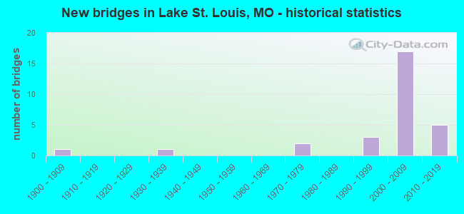
- New bridges - historical statistics
- 11900-1909
- 11930-1939
- 21970-1979
- 31990-1999
- 172000-2009
- 52010-2019

- Reconstructed bridges - Historical Statistics
- 11980-1989
- 01990-1999
- 12000-2009


- Bridge Condition - Deck
- 8.3%Very good
- 66.7%Good
- 16.7%Satisfactory
- 8.3%Fair

- Bridge Condition - Superstructure
- 8.3%Very good
- 75.0%Good
- 8.3%Satisfactory
- 8.3%Fair

- Bridge Condition - Substructure
- 8.3%Very good
- 75.0%Good
- 8.3%Satisfactory
- 8.3%Fair

- Bridge Condition - Channel
- 11.1%Excellent
- 77.8%Satisfactory
- 11.1%Fair

- Bridge Condition - Culverts
- 25.0%Good
- 50.0%Satisfactory
- 25.0%Fair
Find on map >> Show street view
Structure Number: 19764, Location: S 33 T 47 N R 2 E (Lat: 38.803450, Lng: -90.793525), Route carried "on" structure: City street , Year Built: 1970, Status: Open, Structure Length: 0.79m (2.59ft), Average Daily Traffic: 4,200 (year 2020), Truck Traffic: 5%, Average Future Daily Traffic: 6,510 (year 2040), Features Intersected: TRIB OF PERUQUE CR, Facility Carried by Structure: DELOIRE DR
Minimum Vertical Clearance: 30+ m (98+ ft), Kilometerpoint: 0.322, Lanes on structure: 2, Owner: City or Municipal Highway Agency, Approaching Roadway Width: 7.3m (24.0ft), Skew: 1 degrees, Material/Design: Concrete, Design/Construction: Culvert, Number Of Spans In Main Unit: 3, Length of Maximum Span: 2.5m (8.2ft)
Condition: Channel: Satisfactory, Culverts: Fair, Operating Rating: 40.5 metric tons, Method Used To Determine Operating Rating: Allowable Stress (AS), Inventory Rating: 22.5 metric tons, Method Used To Determine Inventory Rating: Allowable Stress (AS), Structural Evaluation: Somewhat better than minimum adequacy, Waterway Adequacy: Equal to present desirable criteria, Approach Roadway Alignment: Equal to present desirable criteria, Designated Inspection Frequency: Every 24 months, Inspection Date: January 2022
Find on map >> Show street view
Structure Number: 19765, Location: S 35 T 47 N R 2 E (Lat: 38.785183, Lng: -90.770950), Route carried "on" structure: City street , Year Built: 1970, Status: Open, Structure Length: 0.76m (2.49ft), Average Daily Traffic: 5,200 (year 2020), Truck Traffic: 5%, Average Future Daily Traffic: 8,060 (year 2040), Features Intersected: TRIB OF PERUQUE CR, Facility Carried by Structure: LK ST LOUIS BLVD
Minimum Vertical Clearance: 30+ m (98+ ft), Kilometerpoint: 0.644, Lanes on structure: 2, Owner: City or Municipal Highway Agency, Approaching Roadway Width: 12.2m (40.0ft), Material/Design: Concrete, Design/Construction: Culvert, Number Of Spans In Main Unit: 3, Length of Maximum Span: 2.4m (7.9ft)
Condition: Channel: Fair, Culverts: Satisfactory, Operating Rating: 42.3 metric tons, Method Used To Determine Operating Rating: Allowable Stress (AS), Inventory Rating: 22.5 metric tons, Method Used To Determine Inventory Rating: Allowable Stress (AS), Structural Evaluation: Somewhat better than minimum adequacy, Waterway Adequacy: Equal to present minimum criteria, Approach Roadway Alignment: Equal to present desirable criteria, Designated Inspection Frequency: Every 24 months, Inspection Date: January 2022
Find on map >> Show street view
Structure Number: 21557, Location: S 1811 T 46 N R 2 E (Lat: 38.772825, Lng: -90.822211), Route carried "on" structure: County highway 311, Year Built: 1900, Year Reconstructed: 1985, Status: Posted for load, Structure Length: 0.91m (2.99ft), Average Daily Traffic: 3,320 (year 2020), Truck Traffic: 10%, Average Future Daily Traffic: 5,146 (year 2040), Features Intersected: TRIB OF PERUQUE CR, Facility Carried by Structure: DUELLO RD
Minimum Vertical Clearance: 30+ m (98+ ft), Kilometerpoint: 3.219, Lanes on structure: 2, Owner: County Highway Agency, Approaching Roadway Width: 6.1m (20.0ft), Material/Design: Steel, Design/Construction: Stringer/Multi-beam, Number Of Spans In Main Unit: 1, Length of Maximum Span: 8.5m (27.9ft), Curb-To-Curb Width: 8.7m (28.5ft), Out-to-Out Width: 9.2m (30.2ft)
Condition: Deck: Fair, Superstructure: Fair, Substructure: Fair, Channel: Satisfactory, Operating Rating: 63.0 metric tons, Method Used To Determine Operating Rating: Load Factor (LF), Inventory Rating: 37.8 metric tons, Method Used To Determine Inventory Rating: Load Factor (LF), Structural Evaluation: Somewhat better than minimum adequacy, Deck Geometry: Meets minimum limits, Waterway Adequacy: Equal to present desirable criteria, Approach Roadway Alignment: Equal to present minimum criteria, Designated Inspection Frequency: Every 24 months, Inspection Date: Febuary 2022, Deck Structure Type: Concrete Cast-file-Place, Wearing Surface/Protective System: Wearing Surface: Bituminous
Find on map >> Show street view
Structure Number: 21576, Location: S 32 T 47 N R 2 E (Lat: 38.786833, Lng: -90.827453), Route carried "on" structure: County highway 312, Year Built: 1999, Status: Open, Structure Length: 5.03m (16.50ft), Average Daily Traffic: 3,494 (year 2020), Truck Traffic: 10%, Average Future Daily Traffic: 5,416 (year 2040), Design Load: HS 20, Features Intersected: PERUQUE CR, Facility Carried by Structure: DUELLO RD
Minimum Vertical Clearance: 30+ m (98+ ft), Kilometerpoint: 1.368, Lanes on structure: 2, Owner: County Highway Agency, Approaching Roadway Width: 12.2m (40.0ft), Skew: 1 degrees, Material/Design: Prestressed concrete, Design/Construction: Stringer/Multi-beam, Number Of Spans In Main Unit: 3, Length of Maximum Span: 19.2m (63.0ft), Curb-To-Curb Width: 12.2m (40.0ft), Out-to-Out Width: 13.0m (42.7ft)
Condition: Deck: Good, Superstructure: Good, Substructure: Good, Channel: Satisfactory, Operating Rating: 60.3 metric tons, Method Used To Determine Operating Rating: Load Factor (LF), Inventory Rating: 36.0 metric tons, Method Used To Determine Inventory Rating: Load Factor (LF), Structural Evaluation: Better than present minimum criteria, Deck Geometry: Equal to present minimum criteria, Waterway Adequacy: Superior to present desirable criteria, Approach Roadway Alignment: Equal to present desirable criteria, Designated Inspection Frequency: Every 24 months, Inspection Date: Febuary 2022, Deck Structure Type: Concrete Cast-file-Place
Find on map >> Show street view
Structure Number: 296, Location: S 2 T 46 N R 2 E (Lat: 38.770372, Lng: -90.777017), Route carried "on" structure: State highway 364, Year Built: 2003, Status: Open, Structure Length: 10.94m (35.89ft), Average Daily Traffic: 29,041 (year 2021), Truck Traffic: 5%, Average Future Daily Traffic: 49,370 (year 2041), Design Load: HS 20+Mod, Features Intersected: IS 64
Minimum Vertical Clearance: 30+ m (98+ ft), Kilometerpoint: 0.473, Lanes on structure: 5, Lanes under structure: 6, Base Highway Network: Yes, Owner: State Highway Agency, Approaching Roadway Width: 8.8m (28.9ft), Skew: 4 degrees, Material/Design: Steel continuous, Design/Construction: Stringer/Multi-beam, Number Of Spans In Main Unit: 4, Length of Maximum Span: 33.5m (109.9ft), Curb-To-Curb Width: 20.8m (68.2ft), Out-to-Out Width: 22.3m (73.2ft)
Condition: Deck: Good, Superstructure: Good, Substructure: Good, Operating Rating: 72.9 metric tons, Method Used To Determine Operating Rating: Load Factor (LF), Inventory Rating: 44.1 metric tons, Method Used To Determine Inventory Rating: Load Factor (LF), Structural Evaluation: Better than present minimum criteria, Deck Geometry: Meets minimum limits, Underclear: High priority of corrective action, Approach Roadway Alignment: Equal to present desirable criteria, Designated Inspection Frequency: Every 24 months, Inspection Date: September 2021, Deck Structure Type: Concrete Cast-file-Place, Wearing Surface/Protective System: Wearing Surface: Epoxy Overlay, Deck Protection: Epoxy Coated Reinforcing
Find on map >> Show street view
Structure Number: 30138, Location: S 26 T 47 N R 2 E (Lat: 38.804022, Lng: -90.770689), Route carried "on" structure: City street , Year Built: 2003, Status: Open, Structure Length: 4.08m (13.39ft), Average Daily Traffic: 6,877 (year 2021), Truck Traffic: 3%, Average Future Daily Traffic: 12,379 (year 2041), Design Load: HS 20, Features Intersected: IS 70, Facility Carried by Structure: LAKE ST LOUIS BLVD
Minimum Vertical Clearance: 30+ m (98+ ft), Kilometerpoint: 10.165, Lanes on structure: 6, Lanes under structure: 6, Owner: State Highway Agency, Approaching Roadway Width: 24.8m (81.4ft), Material/Design: Prestressed concrete continuous, Design/Construction: Box Beam or Girders - Multiple, Number Of Spans In Main Unit: 2, Length of Maximum Span: 20.4m (66.9ft), Curb-To-Curb Width: 24.8m (81.4ft), Out-to-Out Width: 25.6m (84.0ft)
Condition: Deck: Good, Superstructure: Satisfactory, Substructure: Good, Operating Rating: 53.1 metric tons, Method Used To Determine Operating Rating: Load Factor (LF), Inventory Rating: 32.4 metric tons, Method Used To Determine Inventory Rating: Load Factor (LF), Structural Evaluation: Equal to present minimum criteria, Deck Geometry: Somewhat better than minimum adequacy, Underclear: Somewhat better than minimum adequacy, Approach Roadway Alignment: Equal to present desirable criteria, Designated Inspection Frequency: Every 24 months, Inspection Date: September 2021, Deck Structure Type: Concrete Cast-file-Place, Wearing Surface/Protective System: Wearing Surface: Monolithic Concrete, Deck Protection: Epoxy Coated Reinforcing
Find on map >> Show street view
Structure Number: 30676, Location: S 26 T 47 N R 2 E (Lat: 38.802067, Lng: -90.766422), Route carried "on" structure: City street , Year Built: 2004, Status: Open, Structure Length: 4.11m (13.48ft), Average Daily Traffic: 6,000 (year 2020), Truck Traffic: 4%, Average Future Daily Traffic: 9,300 (year 2040), Design Load: HS 20, Features Intersected: PERUQUE CR, LK ST LOUIS, Facility Carried by Structure: LK ST LOUIS BLVD
Minimum Vertical Clearance: 30+ m (98+ ft), Kilometerpoint: 0.161, Lanes on structure: 2, Owner: City or Municipal Highway Agency, Approaching Roadway Width: 9.8m (32.2ft), Material/Design: Steel, Design/Construction: Stringer/Multi-beam, Number Of Spans In Main Unit: 1, Length of Maximum Span: 40.5m (132.9ft), Curb-To-Curb Width: 9.9m (32.5ft), Out-to-Out Width: 13.9m (45.6ft)
Condition: Deck: Good, Superstructure: Very good, Substructure: Good, Channel: Excellent, Operating Rating: 68.4 metric tons, Method Used To Determine Operating Rating: Load Factor (LF), Inventory Rating: 41.4 metric tons, Method Used To Determine Inventory Rating: Load Factor (LF), Structural Evaluation: Better than present minimum criteria, Deck Geometry: Meets minimum limits, Waterway Adequacy: Superior to present desirable criteria, Approach Roadway Alignment: Better than present minimum criteria, Designated Inspection Frequency: Every 24 months, Inspection Date: January 2022, Deck Structure Type: Concrete Cast-file-Place, Wearing Surface/Protective System: Wearing Surface: Monolithic Concrete, Deck Protection: Epoxy Coated Reinforcing
Find on map >> Show street view
Structure Number: 30733, Location: S 3 T 46 N R 2 E (Lat: 38.773956, Lng: -90.782944), Route carried "on" structure: City street , Year Built: 2005, Status: Open, Structure Length: 6.77m (22.21ft), Average Daily Traffic: 8,457 (year 2021), Truck Traffic: 6%, Average Future Daily Traffic: 16,491 (year 2041), Design Load: HS 20, Features Intersected: IS 64, Facility Carried by Structure: RONALD REAGAN DR S
Minimum Vertical Clearance: 30+ m (98+ ft), Kilometerpoint: 1.217, Lanes on structure: 3, Lanes under structure: 6, Owner: State Highway Agency, Approaching Roadway Width: 12.2m (40.0ft), Material/Design: Steel continuous, Design/Construction: Stringer/Multi-beam, Number Of Spans In Main Unit: 2, Length of Maximum Span: 32.9m (107.9ft), Curb or Sidewalk Widths: Left: 1.8m (5.9ft), Right: 0.0m, Curb-To-Curb Width: 12.2m (40.0ft), Out-to-Out Width: 14.8m (48.6ft)
Condition: Deck: Satisfactory, Superstructure: Good, Substructure: Good, Operating Rating: 90.0 metric tons, Method Used To Determine Operating Rating: Load Factor (LF), Inventory Rating: 54.0 metric tons, Method Used To Determine Inventory Rating: Load Factor (LF), Structural Evaluation: Better than present minimum criteria, Deck Geometry: Meets minimum limits, Underclear: Equal to present minimum criteria, Approach Roadway Alignment: Equal to present desirable criteria, Designated Inspection Frequency: Every 24 months, Inspection Date: September 2021, Deck Structure Type: Concrete Cast-file-Place, Wearing Surface/Protective System: Wearing Surface: Epoxy Overlay, Deck Protection: Epoxy Coated Reinforcing
Find on map >> Show street view
Structure Number: 30877, Location: S 54 T 47 N R 2 E (Lat: 38.803567, Lng: -90.764506), Route carried "on" structure: ServiceState highway 70, Year Built: 2005, Status: Open, Structure Length: 6.77m (22.21ft), Average Daily Traffic: 4,487 (year 2021), Truck Traffic: 4%, Average Future Daily Traffic: 8,750 (year 2041), Design Load: HS 20, Features Intersected: PERUQUE CR
Minimum Vertical Clearance: 30+ m (98+ ft), Kilometerpoint: 5.469, Lanes on structure: 2, Owner: State Highway Agency, Approaching Roadway Width: 12.2m (40.0ft), Skew: 1 degrees, Material/Design: Prestressed concrete continuous, Design/Construction: Stringer/Multi-beam, Number Of Spans In Main Unit: 3, Length of Maximum Span: 24.4m (80.1ft), Curb-To-Curb Width: 12.2m (40.0ft), Out-to-Out Width: 13.0m (42.7ft)
Condition: Deck: Good, Superstructure: Good, Substructure: Good, Channel: Satisfactory, Operating Rating: 84.6 metric tons, Method Used To Determine Operating Rating: Load Factor (LF), Inventory Rating: 50.4 metric tons, Method Used To Determine Inventory Rating: Load Factor (LF), Structural Evaluation: Better than present minimum criteria, Deck Geometry: Equal to present minimum criteria, Waterway Adequacy: Superior to present desirable criteria, Approach Roadway Alignment: Equal to present desirable criteria, Designated Inspection Frequency: Every 24 months, Inspection Date: September 2021, Deck Structure Type: Concrete Cast-file-Place, Wearing Surface/Protective System: Wearing Surface: Monolithic Concrete, Deck Protection: Epoxy Coated Reinforcing
Find on map >> Show street view
Structure Number: 31432, Location: S 3 T 46 N R 2 E (Lat: 38.766128, Lng: -90.770311), Route carried "on" structure: State highway N, Year Built: 2006, Status: Open, Structure Length: 14.14m (46.39ft), Average Daily Traffic: 11,965 (year 2021), Truck Traffic: 7%, Average Future Daily Traffic: 21,537 (year 2041), Design Load: HS 20, Features Intersected: IS 64, CST HENKE RD
Minimum Vertical Clearance: 5.49m (18.01ft), Kilometerpoint: 18.351, Lanes on structure: 3, Lanes under structure: 6, Owner: State Highway Agency, Approaching Roadway Width: 20.4m (66.9ft), Skew: 4 degrees, Material/Design: Prestressed concrete continuous, Design/Construction: Tee Beam, Number Of Spans In Main Unit: 4, Length of Maximum Span: 39.0m (128.0ft), Curb or Sidewalk Widths: Left: 1.8m (5.9ft), Right: 0.0m, Curb-To-Curb Width: 20.4m (66.9ft), Out-to-Out Width: 21.2m (69.6ft)
Condition: Deck: Good, Superstructure: Good, Substructure: Good, Operating Rating: 64.8 metric tons, Method Used To Determine Operating Rating: Load Factor (LF), Inventory Rating: 38.7 metric tons, Method Used To Determine Inventory Rating: Load Factor (LF), Structural Evaluation: Better than present minimum criteria, Deck Geometry: Superior to present desirable criteria, Underclear: Equal to present minimum criteria, Approach Roadway Alignment: Equal to present desirable criteria, Designated Inspection Frequency: Every 24 months, Inspection Date: September 2021, Deck Structure Type: Concrete Cast-file-Place, Wearing Surface/Protective System: Wearing Surface: Monolithic Concrete, Deck Protection: Epoxy Coated Reinforcing
Find on map >> Show street view
Structure Number: 31523, Location: S 3 T 46 N R 2 E (Lat: 38.774769, Lng: -90.782003), Route carried "on" structure: City street 232, Year Built: 2005, Status: Open, Structure Length: 2.59m (8.50ft), Average Daily Traffic: 800 (year 2020), Truck Traffic: 10%, Average Future Daily Traffic: 1,240 (year 2040), Design Load: HS 20, Features Intersected: FEISE RD, Facility Carried by Structure: RONALD REAGAN DR
Minimum Vertical Clearance: 30+ m (98+ ft), Kilometerpoint: 0.000, Lanes on structure: 3, Lanes under structure: 2, Owner: City or Municipal Highway Agency, Approaching Roadway Width: 12.2m (40.0ft), Skew: 2 degrees, Material/Design: Prestressed concrete, Design/Construction: Stringer/Multi-beam, Number Of Spans In Main Unit: 1, Length of Maximum Span: 24.1m (79.1ft), Curb or Sidewalk Widths: Left: 1.8m (5.9ft), Right: 0.0m, Curb-To-Curb Width: 12.2m (40.0ft), Out-to-Out Width: 12.8m (42.0ft)
Condition: Deck: Good, Superstructure: Good, Substructure: Satisfactory, Operating Rating: 60.3 metric tons, Method Used To Determine Operating Rating: Load Factor (LF), Inventory Rating: 36.0 metric tons, Method Used To Determine Inventory Rating: Load Factor (LF), Structural Evaluation: Equal to present minimum criteria, Deck Geometry: Meets minimum limits, Approach Roadway Alignment: Equal to present desirable criteria, Designated Inspection Frequency: Every 24 months, Inspection Date: January 2022, Deck Structure Type: Concrete Precast Panels, Wearing Surface/Protective System: Wearing Surface: Monolithic Concrete, Deck Protection: Epoxy Coated Reinforcing
Find on map >> Show street view
Structure Number: 3184, Location: S 33 T 47 N R 2 E (Lat: 38.786519, Lng: -90.803906), Route carried "on" structure: Interstate 64, Year Built: 2009, Status: Open, Structure Length: 7.79m (25.56ft), Average Daily Traffic: 33,411 (year 2021), Truck Traffic: 12%, Average Future Daily Traffic: 56,799 (year 2041), Design Load: HS 25 or greater, Features Intersected: PERUQUE CR
Minimum Vertical Clearance: 30+ m (98+ ft), Kilometerpoint: 3.991, Lanes on structure: 2, Base Highway Network: Yes, Owner: State Highway Agency, Approaching Roadway Width: 12.2m (40.0ft), Material/Design: Steel continuous, Design/Construction: Stringer/Multi-beam, Number Of Spans In Main Unit: 2, Length of Maximum Span: 43.3m (142.1ft), Curb-To-Curb Width: 12.5m (41.0ft), Out-to-Out Width: 13.4m (44.0ft)
Condition: Deck: Satisfactory, Superstructure: Good, Substructure: Good, Channel: Satisfactory, Operating Rating: 59.4 metric tons, Method Used To Determine Operating Rating: Load Factor (LF), Inventory Rating: 36.0 metric tons, Method Used To Determine Inventory Rating: Load Factor (LF), Structural Evaluation: Better than present minimum criteria, Deck Geometry: Better than present minimum criteria, Waterway Adequacy: Superior to present desirable criteria, Approach Roadway Alignment: Equal to present desirable criteria, Designated Inspection Frequency: Every 24 months, Underwater Inspection Frequency: Every 60 months, Inspection Date: September 2021, Underwater Inspection Date: October 2021, Deck Structure Type: Concrete Cast-file-Place, Wearing Surface/Protective System: Wearing Surface: Monolithic Concrete, Deck Protection: Epoxy Coated Reinforcing
Find on map >> Show street view
Structure Number: 34556, Location: S 1 T 46 N R 2 E (Lat: 38.771047, Lng: -90.770186), Route carried "on" structure: State highway 364, Year Built: 2013, Status: Open, Structure Length: 2.07m (6.79ft), Average Daily Traffic: 16,867 (year 2021), Truck Traffic: 6%, Average Future Daily Traffic: 28,674 (year 2041), Features Intersected: CST HENKE RD
Minimum Vertical Clearance: 30+ m (98+ ft), Kilometerpoint: 1.118, Lanes on structure: 3, Lanes under structure: 3, Base Highway Network: Yes, Owner: State Highway Agency, Approaching Roadway Width: 14.1m (46.3ft), Material/Design: Prestressed concrete, Design/Construction: Stringer/Multi-beam, Number Of Spans In Main Unit: 1, Length of Maximum Span: 19.8m (65.0ft), Curb-To-Curb Width: 14.1m (46.3ft), Out-to-Out Width: 14.9m (48.9ft)
Condition: Deck: Very good, Superstructure: Good, Substructure: Very good, Operating Rating: 71.1 metric tons, Method Used To Determine Operating Rating: Load Factor (LF), Inventory Rating: 38.7 metric tons, Method Used To Determine Inventory Rating: Load Factor (LF), Structural Evaluation: Better than present minimum criteria, Deck Geometry: Meets minimum limits, Underclear: Meets minimum limits, Approach Roadway Alignment: Equal to present desirable criteria, Designated Inspection Frequency: Every 24 months, Inspection Date: September 2021, Deck Structure Type: Concrete Cast-file-Place, Wearing Surface/Protective System: Wearing Surface: Monolithic Concrete, Deck Protection: Epoxy Coated Reinforcing
Find on map >> Show street view
Structure Number: 34557, Location: S 1 T 46 N R 2 E (Lat: 38.771300, Lng: -90.770200), Route carried "on" structure: State highway 364, Year Built: 2013, Status: Open, Structure Length: 2.07m (6.79ft), Average Daily Traffic: 17,917 (year 2021), Truck Traffic: 5%, Average Future Daily Traffic: 30,459 (year 2041), Features Intersected: CST HENKE RD
Minimum Vertical Clearance: 30+ m (98+ ft), Kilometerpoint: 33.265, Lanes on structure: 2, Lanes under structure: 3, Base Highway Network: Yes, Owner: State Highway Agency, Approaching Roadway Width: 11.7m (38.4ft), Material/Design: Prestressed concrete, Design/Construction: Stringer/Multi-beam, Number Of Spans In Main Unit: 1, Length of Maximum Span: 19.8m (65.0ft), Curb-To-Curb Width: 11.7m (38.4ft), Out-to-Out Width: 12.5m (41.0ft)
Condition: Deck: Good, Superstructure: Good, Substructure: Good, Operating Rating: 70.2 metric tons, Method Used To Determine Operating Rating: Load Factor (LF), Inventory Rating: 40.5 metric tons, Method Used To Determine Inventory Rating: Load Factor (LF), Structural Evaluation: Better than present minimum criteria, Deck Geometry: Equal to present minimum criteria, Underclear: Meets minimum limits, Approach Roadway Alignment: Equal to present desirable criteria, Designated Inspection Frequency: Every 24 months, Inspection Date: September 2021, Deck Structure Type: Concrete Cast-file-Place, Wearing Surface/Protective System: Wearing Surface: Monolithic Concrete, Deck Protection: Epoxy Coated Reinforcing
Find on map >> Show street view
Structure Number: 35032, Location: S 8 T 46 N R 2 E (Lat: 38.754944, Lng: -90.824750), Route carried "on" structure: State highway 309, Year Built: 2015, Status: Open, Structure Length: 0.81m (2.66ft), Average Daily Traffic: 2,214 (year 2020), Truck Traffic: 15%, Average Future Daily Traffic: 3,432 (year 2040), Features Intersected: TRIB TO DARDENNE C, Facility Carried by Structure: HOPEWELL RD
Minimum Vertical Clearance: 30+ m (98+ ft), Kilometerpoint: 0.805, Lanes on structure: 2, Owner: County Highway Agency, Approaching Roadway Width: 7.9m (25.9ft), Material/Design: Steel, Design/Construction: Culvert, Number Of Spans In Main Unit: 3, Length of Maximum Span: 2.4m (7.9ft), Curb-To-Curb Width: 12.2m (40.0ft), Out-to-Out Width: 15.4m (50.5ft)
Condition: Channel: Satisfactory, Culverts: Good, Operating Rating: 56.7 metric tons, Method Used To Determine Operating Rating: Load Factor (LF), Inventory Rating: 33.3 metric tons, Method Used To Determine Inventory Rating: Load Factor (LF), Structural Evaluation: Better than present minimum criteria, Deck Geometry: Equal to present minimum criteria, Waterway Adequacy: Superior to present desirable criteria, Approach Roadway Alignment: Equal to present desirable criteria, Designated Inspection Frequency: Every 24 months, Inspection Date: Febuary 2022, Wearing Surface/Protective System: Wearing Surface: Bituminous
Find on map >> Show street view
Structure Number: 5617, Location: S 33 T 47 N R 2 E (Lat: 38.783667, Lng: -90.800056), Route carried "on" structure: Interstate 64, Year Built: 1935, Year Reconstructed: 2007, Status: Open, Structure Length: 0.73m (2.40ft), Average Daily Traffic: 66,218 (year 2021), Truck Traffic: 12%, Average Future Daily Traffic: 112,571 (year 2041), Design Load: H 15, Features Intersected: PERUQUE CR
Minimum Vertical Clearance: 30+ m (98+ ft), Kilometerpoint: 4.437, Lanes on structure: 8, Base Highway Network: Yes, Owner: State Highway Agency, Approaching Roadway Width: 29.3m (96.1ft), Skew: 24 degrees, Material/Design: Concrete continuous, Design/Construction: Culvert, Number Of Spans In Main Unit: 2, Length of Maximum Span: 2.4m (7.9ft)
Condition: Channel: Satisfactory, Culverts: Satisfactory, Operating Rating: 66.6 metric tons, Method Used To Determine Operating Rating: Load Factor (LF), Inventory Rating: 39.6 metric tons, Method Used To Determine Inventory Rating: Load Factor (LF), Structural Evaluation: Equal to present minimum criteria, Waterway Adequacy: Equal to present desirable criteria, Approach Roadway Alignment: Equal to present desirable criteria, Designated Inspection Frequency: Every 24 months, Inspection Date: November 2021
Find on map >> Show street view
Structure Number: 296, Location: S 2 T 46 N R 2 E (Lat: 38.770372, Lng: -90.777017), Route carried "under" structure: Interstate 64, Year Built: 2003, Structure Length: 0. m, Average Daily Traffic: 21,430 (year 2021), Truck Traffic: 7%, Features Intersected: IS 64
Minimum Vertical Clearance: 5.33m (17.49ft), Kilometerpoint: 58.698, Lanes on structure: 5, Lanes under structure: 3, Material/Design: Steel continuous, Design/Construction: Stringer/Multi-beam, Length of Maximum Span: 33.5m (109.9ft)
Find on map >> Show street view
Structure Number: 296, Location: S 2 T 46 N R 2 E (Lat: 38.770372, Lng: -90.777017), Route carried "under" structure: Interstate 64, Year Built: 2003, Structure Length: 0. m, Average Daily Traffic: 26,276 (year 2021), Truck Traffic: 12%, Features Intersected: IS 64
Minimum Vertical Clearance: 5.44m (17.85ft), Kilometerpoint: 6.968, Lanes on structure: 5, Lanes under structure: 3, Material/Design: Steel continuous, Design/Construction: Stringer/Multi-beam, Length of Maximum Span: 33.5m (109.9ft)
Find on map >> Show street view
Structure Number: 30138, Location: S 26 T 47 N R 2 E (Lat: 38.804022, Lng: -90.770689), Route carried "under" structure: Interstate 70, Year Built: 2003, Structure Length: 0. m, Average Daily Traffic: 43,574 (year 2021), Truck Traffic: 12%, Features Intersected: IS 70, Facility Carried by Structure: LAKE ST LOUIS BLVD
Minimum Vertical Clearance: 5.00m (16.40ft), Kilometerpoint: 344.486, Lanes on structure: 6, Lanes under structure: 3, Material/Design: Prestressed concrete continuous, Design/Construction: Box Beam or Girders - Multiple, Length of Maximum Span: 20.4m (66.9ft)
Find on map >> Show street view
Structure Number: 30138, Location: S 26 T 47 N R 2 E (Lat: 38.804022, Lng: -90.770689), Route carried "under" structure: Interstate 70, Year Built: 2003, Structure Length: 0. m, Average Daily Traffic: 46,582 (year 2021), Truck Traffic: 12%, Features Intersected: IS 70, Facility Carried by Structure: LAKE ST LOUIS BLVD
Minimum Vertical Clearance: 5.05m (16.57ft), Kilometerpoint: 58.051, Lanes on structure: 6, Lanes under structure: 3, Material/Design: Prestressed concrete continuous, Design/Construction: Box Beam or Girders - Multiple, Length of Maximum Span: 20.4m (66.9ft)
Find on map >> Show street view
Structure Number: 30733, Location: S 3 T 46 N R 2 E (Lat: 38.773956, Lng: -90.782944), Route carried "under" structure: Interstate 64, Year Built: 2005, Structure Length: 0. m, Average Daily Traffic: 32,807 (year 2021), Truck Traffic: 7%, Features Intersected: IS 64, Facility Carried by Structure: RONALD REAGAN DR S
Minimum Vertical Clearance: 5.10m (16.73ft), Kilometerpoint: 59.366, Lanes on structure: 3, Lanes under structure: 3, Material/Design: Steel continuous, Design/Construction: Stringer/Multi-beam, Length of Maximum Span: 32.9m (107.9ft)
Find on map >> Show street view
Structure Number: 30733, Location: S 3 T 46 N R 2 E (Lat: 38.773956, Lng: -90.782944), Route carried "under" structure: Interstate 64, Year Built: 2005, Structure Length: 0. m, Average Daily Traffic: 33,411 (year 2021), Truck Traffic: 12%, Features Intersected: IS 64, Facility Carried by Structure: RONALD REAGAN DR S
Minimum Vertical Clearance: 5.06m (16.60ft), Kilometerpoint: 6.318, Lanes on structure: 3, Lanes under structure: 3, Material/Design: Steel continuous, Design/Construction: Stringer/Multi-beam, Length of Maximum Span: 32.9m (107.9ft)
Find on map >> Show street view
Structure Number: 31432, Location: S 3 T 46 N R 2 E (Lat: 38.766128, Lng: -90.770311), Route carried "under" structure: Interstate 64, Year Built: 2006, Structure Length: 0. m, Average Daily Traffic: 26,276 (year 2021), Truck Traffic: 12%, Features Intersected: IS 64, Facility Carried by Structure: RT N E
Minimum Vertical Clearance: 5.41m (17.75ft), Kilometerpoint: 7.696, Lanes on structure: 3, Lanes under structure: 2, Material/Design: Prestressed concrete continuous, Design/Construction: Tee Beam, Length of Maximum Span: 39.0m (128.0ft)
Find on map >> Show street view
Structure Number: 31432, Location: S 3 T 46 N R 2 E (Lat: 38.766128, Lng: -90.770311), Route carried "under" structure: Interstate 64, Year Built: 2006, Structure Length: 0. m, Average Daily Traffic: 21,430 (year 2021), Truck Traffic: 7%, Features Intersected: IS 64, Facility Carried by Structure: RT N E
Minimum Vertical Clearance: 5.49m (18.01ft), Kilometerpoint: 57.961, Lanes on structure: 3, Lanes under structure: 2, Material/Design: Prestressed concrete continuous, Design/Construction: Tee Beam, Length of Maximum Span: 39.0m (128.0ft)
Find on map >> Show street view
Structure Number: 31432, Location: S 3 T 46 N R 2 E (Lat: 38.766128, Lng: -90.770311), Route carried "under" structure: City street , Year Built: 2006, Structure Length: 0. m, Average Daily Traffic: 9,772 (year 2021), Truck Traffic: 5%, Features Intersected: CST HENKE RD, Facility Carried by Structure: RT N E
Minimum Vertical Clearance: 5.72m (18.77ft), Kilometerpoint: 2.062, Lanes on structure: 3, Lanes under structure: 2, Material/Design: Prestressed concrete continuous, Design/Construction: Tee Beam, Length of Maximum Span: 39.0m (128.0ft)
Find on map >> Show street view
Structure Number: 34556, Location: S 1 T 46 N R 2 E (Lat: 38.771047, Lng: -90.770186), Route carried "under" structure: City street , Year Built: 2013, Structure Length: 0. m, Average Daily Traffic: 9,772 (year 2021), Truck Traffic: 5%, Features Intersected: CST HENKE RD, Facility Carried by Structure: MO 364 E
Minimum Vertical Clearance: 5.59m (18.34ft), Kilometerpoint: 1.510, Lanes on structure: 3, Lanes under structure: 3, Material/Design: Prestressed concrete, Design/Construction: Stringer/Multi-beam, Length of Maximum Span: 19.8m (65.0ft)
Find on map >> Show street view
Structure Number: 34557, Location: S 1 T 46 N R 2 E (Lat: 38.771300, Lng: -90.770200), Route carried "under" structure: City street , Year Built: 2013, Structure Length: 0. m, Average Daily Traffic: 9,772 (year 2021), Truck Traffic: 5%, Features Intersected: CST HENKE RD, Facility Carried by Structure: MO 364 W
Minimum Vertical Clearance: 5.28m (17.32ft), Kilometerpoint: 1.487, Lanes on structure: 2, Lanes under structure: 3, Material/Design: Prestressed concrete, Design/Construction: Stringer/Multi-beam, Length of Maximum Span: 19.8m (65.0ft)
Find on map >> Show street view
Structure Number: 4256, Location: S 35 T 47 N R 2 E (Lat: 38.781839, Lng: -90.795950), Route carried "under" structure: Interstate 64, Year Built: 1996, Structure Length: 0. m, Average Daily Traffic: 32,807 (year 2021), Truck Traffic: 7%, Features Intersected: IS 64, Facility Carried by Structure: LAKE ST LOUIS BLVD
Minimum Vertical Clearance: 5.77m (18.93ft), Kilometerpoint: 60.795, Lanes on structure: 4, Lanes under structure: 3, Material/Design: Steel continuous, Design/Construction: Stringer/Multi-beam, Length of Maximum Span: 34.7m (113.8ft)
Find on map >> Show street view
Structure Number: 4256, Location: S 35 T 47 N R 2 E (Lat: 38.781839, Lng: -90.795950), Route carried "under" structure: Interstate 64, Year Built: 1996, Structure Length: 0. m, Average Daily Traffic: 33,411 (year 2021), Truck Traffic: 12%, Features Intersected: IS 64, Facility Carried by Structure: LAKE ST LOUIS BLVD
Minimum Vertical Clearance: 5.77m (18.93ft), Kilometerpoint: 4.889, Lanes on structure: 4, Lanes under structure: 3, Material/Design: Steel continuous, Design/Construction: Stringer/Multi-beam, Length of Maximum Span: 34.7m (113.8ft)