Bridge Statistics for La Feria, Texas (TX)
Condition, Traffic, Stress, Structural Evaluation, Project Costs
- National Bridge Inventory (NBI) Statistics
- 20Number of bridges
- 394ft / 120mTotal length
- $1,000Total costs
- 329,615Total average daily traffic
- 33,308Total average daily truck traffic
- National Bridge Inventory (NBI) Registered Bridges for La Feria
- No street view available for this location
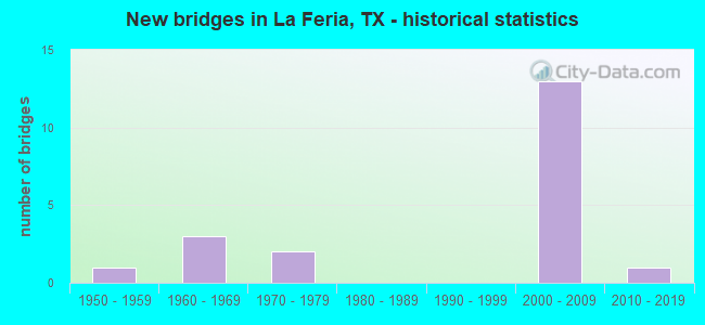
- New bridges - historical statistics
- 11950-1959
- 31960-1969
- 21970-1979
- 132000-2009
- 12010-2019


- Bridge Condition - Deck
- 81.8%Good
- 18.2%Satisfactory

- Bridge Condition - Superstructure
- 27.3%Very good
- 54.5%Good
- 18.2%Satisfactory

- Bridge Condition - Substructure
- 81.8%Good
- 18.2%Satisfactory

- Bridge Condition - Channel
- 25.0%Good
- 75.0%Satisfactory
Find on map >> Show street view
Structure Number: 210310003919014, Location: 0.22 MI W OF FM 2556 (Lat: 26.162303, Lng: -97.851756), Route carried "on" structure: US 83, Year Built: 2007, Status: Open, Structure Length: 1.10m (3.61ft), Average Daily Traffic: 54,080 (year 2011), Truck Traffic: 9%, Average Future Daily Traffic: 75,710 (year 2031), Design Load: HS 20, Features Intersected: WILLACY CANAL
Minimum Vertical Clearance: 30+ m (98+ ft), Kilometerpoint: 1.061, Lanes on structure: 13, Owner: State Highway Agency, Approaching Roadway Width: 58.5m (191.9ft), Skew: 2 degrees, Material/Design: Concrete, Design/Construction: Culvert, Number Of Spans In Main Unit: 3, Length of Maximum Span: 2.7m (8.9ft)
Condition: Channel: Good, Culverts: Good, Operating Rating: 54.4 metric tons, Method Used To Determine Operating Rating: Assigned rating based on Load Factor Design (LFD) reported in metric tons, Inventory Rating: 32.7 metric tons, Method Used To Determine Inventory Rating: Assigned rating based on Load Factor Design (LFD) reported in metric tons, Structural Evaluation: Better than present minimum criteria, Waterway Adequacy: Equal to present minimum criteria, Approach Roadway Alignment: Equal to present desirable criteria, Designated Inspection Frequency: Every 48 months, Inspection Date: March 2021
Find on map >> Show street view
Structure Number: 210310003919184, Location: 1.50 MI W OF FM 506 (Lat: 26.163653, Lng: -97.848583), Route carried "on" structure: State highway 2556, Year Built: 1969, Status: Open, Structure Length: 12.74m (41.80ft), Average Daily Traffic: 3,093 (year 2020), Truck Traffic: 25%, Average Future Daily Traffic: 2,200 (year 2033), Design Load: HS 20, Features Intersected: US 83
Minimum Vertical Clearance: 30+ m (98+ ft), Kilometerpoint: 30.032, Lanes on structure: 2, Lanes under structure: 12, Owner: State Highway Agency, Approaching Roadway Width: 12.2m (40.0ft), Skew: 2 degrees, Material/Design: Prestressed concrete, Design/Construction: Stringer/Multi-beam, Number Of Spans In Main Unit: 4, Number Of Approach Spans: 2, Length of Maximum Span: 25.9m (85.0ft), Curb-To-Curb Width: 12.2m (40.0ft), Out-to-Out Width: 12.9m (42.3ft)
Condition: Deck: Good, Superstructure: Good, Substructure: Satisfactory, Operating Rating: 44.4 metric tons, Method Used To Determine Operating Rating: Assigned ratings based on Allowable Stress Design (ASD) reported in metric tons, Inventory Rating: 32.7 metric tons, Method Used To Determine Inventory Rating: Assigned ratings based on Allowable Stress Design (ASD) reported in metric tons, Structural Evaluation: Equal to present minimum criteria, Deck Geometry: Equal to present minimum criteria, Underclear: High priority of corrective action, Approach Roadway Alignment: Equal to present desirable criteria, Designated Inspection Frequency: Every 24 months, Inspection Date: March 2021, Deck Structure Type: Concrete Cast-file-Place
Find on map >> Show street view
Structure Number: 210310003919191, Location: 2.15 MI E OF FM 2556 (Lat: 26.167614, Lng: -97.813564), Route carried "on" structure: State highway 733, Year Built: 1970, Status: Open, Structure Length: 13.29m (43.60ft), Average Daily Traffic: 1,893 (year 2020), Truck Traffic: 2%, Average Future Daily Traffic: 2,600 (year 2033), Design Load: HS 20, Features Intersected: US 83
Minimum Vertical Clearance: 30+ m (98+ ft), Kilometerpoint: 4.490, Lanes on structure: 2, Lanes under structure: 12, Owner: State Highway Agency, Approaching Roadway Width: 12.8m (42.0ft), Skew: 2 degrees, Material/Design: Prestressed concrete, Design/Construction: Stringer/Multi-beam, Number Of Spans In Main Unit: 4, Number Of Approach Spans: 2, Length of Maximum Span: 27.1m (88.9ft), Curb-To-Curb Width: 12.8m (42.0ft), Out-to-Out Width: 13.5m (44.3ft)
Condition: Deck: Good, Superstructure: Good, Substructure: Good, Operating Rating: 54.4 metric tons, Method Used To Determine Operating Rating: Assigned rating based on Load Factor Design (LFD) reported in metric tons, Inventory Rating: 32.7 metric tons, Method Used To Determine Inventory Rating: Assigned rating based on Load Factor Design (LFD) reported in metric tons, Structural Evaluation: Better than present minimum criteria, Deck Geometry: Better than present minimum criteria, Underclear: Equal to present minimum criteria, Approach Roadway Alignment: Equal to present desirable criteria, Designated Inspection Frequency: Every 24 months, Inspection Date: March 2021, Deck Structure Type: Concrete Cast-file-Place
Find on map >> Show street view
Structure Number: 210310003919395, Location: 0.75 MI W OF FM 506 (Lat: 26.165608, Lng: -97.836194), Route carried "on" structure: US 83, Year Built: 2008, Status: Open, Structure Length: 6.19m (20.31ft), Average Daily Traffic: 24,530 (year 2011), Truck Traffic: 10%, Average Future Daily Traffic: 38,260 (year 2031), Design Load: HL 93, Features Intersected: RABB RD
Minimum Vertical Clearance: 30+ m (98+ ft), Kilometerpoint: 2.630, Lanes on structure: 4, Lanes under structure: 6, Owner: State Highway Agency, Approaching Roadway Width: 20.7m (67.9ft), Material/Design: Prestressed concrete, Design/Construction: Stringer/Multi-beam, Number Of Spans In Main Unit: 1, Number Of Approach Spans: 2, Length of Maximum Span: 29.0m (95.1ft), Curb-To-Curb Width: 20.7m (67.9ft), Out-to-Out Width: 21.6m (70.9ft)
Condition: Deck: Good, Superstructure: Good, Substructure: Good, Operating Rating: 54.4 metric tons, Method Used To Determine Operating Rating: Assigned ratings based on Load and Resistance Factor Design (LRFD) reported in metric tons, Inventory Rating: 32.7 metric tons, Method Used To Determine Inventory Rating: Assigned ratings based on Load and Resistance Factor Design (LRFD) reported in metric tons, Structural Evaluation: Better than present minimum criteria, Deck Geometry: Equal to present minimum criteria, Underclear: Superior to present desirable criteria, Approach Roadway Alignment: Equal to present desirable criteria, Designated Inspection Frequency: Every 24 months, Inspection Date: March 2021, Deck Structure Type: Concrete Precast Panels
Find on map >> Show street view
Structure Number: 210310003919396, Location: 0.75 MI W OF FM 506 (Lat: 26.165289, Lng: -97.836778), Route carried "on" structure: US 83, Year Built: 2008, Status: Open, Structure Length: 6.19m (20.31ft), Average Daily Traffic: 24,530 (year 2011), Truck Traffic: 10%, Average Future Daily Traffic: 38,260 (year 2031), Design Load: HL 93, Features Intersected: RABB RD
Minimum Vertical Clearance: 30+ m (98+ ft), Kilometerpoint: 2.630, Lanes on structure: 4, Lanes under structure: 6, Owner: State Highway Agency, Approaching Roadway Width: 20.7m (67.9ft), Material/Design: Prestressed concrete, Design/Construction: Stringer/Multi-beam, Number Of Spans In Main Unit: 1, Number Of Approach Spans: 2, Length of Maximum Span: 29.0m (95.1ft), Curb-To-Curb Width: 20.7m (67.9ft), Out-to-Out Width: 21.6m (70.9ft)
Condition: Deck: Good, Superstructure: Very good, Substructure: Good, Operating Rating: 54.4 metric tons, Method Used To Determine Operating Rating: Assigned ratings based on Load and Resistance Factor Design (LRFD) reported in metric tons, Inventory Rating: 32.7 metric tons, Method Used To Determine Inventory Rating: Assigned ratings based on Load and Resistance Factor Design (LRFD) reported in metric tons, Structural Evaluation: Better than present minimum criteria, Deck Geometry: Equal to present minimum criteria, Underclear: Superior to present desirable criteria, Approach Roadway Alignment: Equal to present desirable criteria, Designated Inspection Frequency: Every 24 months, Inspection Date: March 2021, Deck Structure Type: Concrete Precast Panels
Find on map >> Show street view
Structure Number: 210310003919397, Location: 1.50 MI E OF FM 2556 (Lat: 26.165544, Lng: -97.824475), Route carried "on" structure: US 83, Year Built: 2009, Status: Open, Structure Length: 6.71m (22.01ft), Average Daily Traffic: 24,530 (year 2011), Truck Traffic: 10%, Average Future Daily Traffic: 38,260 (year 2031), Design Load: HL 93, Features Intersected: FM 506
Minimum Vertical Clearance: 30+ m (98+ ft), Kilometerpoint: 3.861, Lanes on structure: 4, Lanes under structure: 8, Owner: State Highway Agency, Approaching Roadway Width: 20.7m (67.9ft), Material/Design: Prestressed concrete, Design/Construction: Stringer/Multi-beam, Number Of Spans In Main Unit: 1, Number Of Approach Spans: 2, Length of Maximum Span: 34.1m (111.9ft), Curb-To-Curb Width: 20.7m (67.9ft), Out-to-Out Width: 21.6m (70.9ft)
Condition: Deck: Good, Superstructure: Good, Substructure: Good, Operating Rating: 54.4 metric tons, Method Used To Determine Operating Rating: Assigned ratings based on Load and Resistance Factor Design (LRFD) reported in metric tons, Inventory Rating: 32.7 metric tons, Method Used To Determine Inventory Rating: Assigned ratings based on Load and Resistance Factor Design (LRFD) reported in metric tons, Structural Evaluation: Better than present minimum criteria, Deck Geometry: Equal to present minimum criteria, Underclear: Superior to present desirable criteria, Approach Roadway Alignment: Equal to present desirable criteria, Designated Inspection Frequency: Every 24 months, Inspection Date: March 2021, Deck Structure Type: Concrete Precast Panels
Find on map >> Show street view
Structure Number: 210310003919398, Location: 1.50 MI E OF FM 2556 (Lat: 26.165664, Lng: -97.823789), Route carried "on" structure: US 83, Year Built: 2009, Status: Open, Structure Length: 6.71m (22.01ft), Average Daily Traffic: 24,530 (year 2011), Truck Traffic: 10%, Average Future Daily Traffic: 38,260 (year 2031), Design Load: HL 93, Features Intersected: FM 506
Minimum Vertical Clearance: 30+ m (98+ ft), Kilometerpoint: 3.861, Lanes on structure: 4, Lanes under structure: 8, Owner: State Highway Agency, Approaching Roadway Width: 20.7m (67.9ft), Material/Design: Prestressed concrete, Design/Construction: Stringer/Multi-beam, Number Of Spans In Main Unit: 1, Number Of Approach Spans: 2, Length of Maximum Span: 34.1m (111.9ft), Curb-To-Curb Width: 20.7m (67.9ft), Out-to-Out Width: 21.6m (70.9ft)
Condition: Deck: Good, Superstructure: Good, Substructure: Good, Operating Rating: 54.4 metric tons, Method Used To Determine Operating Rating: Assigned ratings based on Load and Resistance Factor Design (LRFD) reported in metric tons, Inventory Rating: 32.7 metric tons, Method Used To Determine Inventory Rating: Assigned ratings based on Load and Resistance Factor Design (LRFD) reported in metric tons, Structural Evaluation: Better than present minimum criteria, Deck Geometry: Equal to present minimum criteria, Underclear: Superior to present desirable criteria, Approach Roadway Alignment: Equal to present desirable criteria, Designated Inspection Frequency: Every 24 months, Inspection Date: March 2021, Deck Structure Type: Concrete Precast Panels
Find on map >> Show street view
Structure Number: 210310003919399, Location: 0.90 MI E OF FM 733 (Lat: 26.174275, Lng: -97.801253), Route carried "on" structure: US 83, Year Built: 2008, Status: Open, Structure Length: 7.19m (23.59ft), Average Daily Traffic: 26,570 (year 2011), Truck Traffic: 10%, Average Future Daily Traffic: 37,200 (year 2031), Design Load: HL 93, Features Intersected: WHITE RANCH RD
Minimum Vertical Clearance: 30+ m (98+ ft), Kilometerpoint: 6.347, Lanes on structure: 4, Lanes under structure: 6, Owner: State Highway Agency, Approaching Roadway Width: 20.7m (67.9ft), Skew: 3 degrees, Material/Design: Prestressed concrete, Design/Construction: Stringer/Multi-beam, Number Of Spans In Main Unit: 1, Number Of Approach Spans: 2, Length of Maximum Span: 33.5m (109.9ft), Curb-To-Curb Width: 20.7m (67.9ft), Out-to-Out Width: 21.6m (70.9ft)
Condition: Deck: Good, Superstructure: Very good, Substructure: Good, Operating Rating: 54.4 metric tons, Method Used To Determine Operating Rating: Assigned ratings based on Load and Resistance Factor Design (LRFD) reported in metric tons, Inventory Rating: 32.7 metric tons, Method Used To Determine Inventory Rating: Assigned ratings based on Load and Resistance Factor Design (LRFD) reported in metric tons, Structural Evaluation: Better than present minimum criteria, Deck Geometry: Equal to present minimum criteria, Underclear: Superior to present desirable criteria, Approach Roadway Alignment: Equal to present desirable criteria, Designated Inspection Frequency: Every 24 months, Inspection Date: March 2021, Deck Structure Type: Concrete Precast Panels
Find on map >> Show street view
Structure Number: 2103100039194, Location: 0.90 MI E OF FM 733 (Lat: 26.173608, Lng: -97.801858), Route carried "on" structure: US 83, Year Built: 2008, Status: Open, Structure Length: 7.19m (23.59ft), Average Daily Traffic: 26,570 (year 2011), Truck Traffic: 10%, Average Future Daily Traffic: 37,200 (year 2031), Design Load: HL 93, Features Intersected: WHITE RANCH RD
Minimum Vertical Clearance: 30+ m (98+ ft), Kilometerpoint: 6.347, Lanes on structure: 4, Lanes under structure: 6, Owner: State Highway Agency, Approaching Roadway Width: 20.7m (67.9ft), Skew: 3 degrees, Material/Design: Prestressed concrete, Design/Construction: Stringer/Multi-beam, Number Of Spans In Main Unit: 1, Number Of Approach Spans: 2, Length of Maximum Span: 33.5m (109.9ft), Curb-To-Curb Width: 20.7m (67.9ft), Out-to-Out Width: 21.6m (70.9ft)
Condition: Deck: Good, Superstructure: Very good, Substructure: Good, Operating Rating: 54.4 metric tons, Method Used To Determine Operating Rating: Assigned ratings based on Load and Resistance Factor Design (LRFD) reported in metric tons, Inventory Rating: 32.7 metric tons, Method Used To Determine Inventory Rating: Assigned ratings based on Load and Resistance Factor Design (LRFD) reported in metric tons, Structural Evaluation: Better than present minimum criteria, Deck Geometry: Equal to present minimum criteria, Underclear: Superior to present desirable criteria, Approach Roadway Alignment: Equal to present desirable criteria, Designated Inspection Frequency: Every 24 months, Inspection Date: March 2021, Deck Structure Type: Concrete Precast Panels
Find on map >> Show street view
Structure Number: 210310087204004, Location: 0.90 MI N OF FM 3067 (Lat: 26.129736, Lng: -97.823650), Route carried "on" structure: State highway 506, Year Built: 1958, Year Reconstructed: 1998, Status: Open, Structure Length: 9.24m (30.31ft), Average Daily Traffic: 2,026 (year 2020), Truck Traffic: 20%, Average Future Daily Traffic: 3,010 (year 2033), Features Intersected: ARROYO COLORADO
Minimum Vertical Clearance: 30+ m (98+ ft), Kilometerpoint: 13.073, Lanes on structure: 2, Owner: State Highway Agency, Approaching Roadway Width: 12.2m (40.0ft), Material/Design: Concrete, Design/Construction: Stringer/Multi-beam, Number Of Spans In Main Unit: 10, Length of Maximum Span: 9.1m (29.9ft), Curb-To-Curb Width: 13.1m (43.0ft), Out-to-Out Width: 13.8m (45.3ft)
Condition: Deck: Satisfactory, Superstructure: Satisfactory, Substructure: Satisfactory, Channel: Satisfactory, Operating Rating: 68.0 metric tons, Method Used To Determine Operating Rating: Load Factor (LF), Inventory Rating: 40.8 metric tons, Method Used To Determine Inventory Rating: Load Factor (LF), Structural Evaluation: Equal to present minimum criteria, Deck Geometry: Equal to present minimum criteria, Waterway Adequacy: Equal to present minimum criteria, Approach Roadway Alignment: Equal to present desirable criteria, Designated Inspection Frequency: Every 24 months, Inspection Date: March 2021, Deck Structure Type: Concrete Cast-file-Place
Find on map >> Show street view
Structure Number: 210310113602196, Location: 1.3 MI N OF FM 3067 (Lat: 26.134917, Lng: -97.785500), Route carried "on" structure: State highway 800, Year Built: 2012, Status: Open, Structure Length: 41.61m (136.52ft), Average Daily Traffic: 1,313 (year 2018), Truck Traffic: 20%, Average Future Daily Traffic: 2,800 (year 2032), Design Load: HL 93, Features Intersected: ARROYO COLORADO
Minimum Vertical Clearance: 30+ m (98+ ft), Kilometerpoint: 12.358, Lanes on structure: 2, Owner: State Highway Agency, Approaching Roadway Width: 15.9m (52.2ft), Material/Design: Prestressed concrete, Design/Construction: Stringer/Multi-beam, Number Of Spans In Main Unit: 13, Length of Maximum Span: 32.0m (105.0ft), Curb-To-Curb Width: 15.7m (51.5ft), Out-to-Out Width: 16.5m (54.1ft)
Condition: Deck: Good, Superstructure: Good, Substructure: Good, Channel: Satisfactory, Operating Rating: 54.4 metric tons, Method Used To Determine Operating Rating: Assigned ratings based on Load and Resistance Factor Design (LRFD) reported in metric tons, Inventory Rating: 32.7 metric tons, Method Used To Determine Inventory Rating: Assigned ratings based on Load and Resistance Factor Design (LRFD) reported in metric tons, Structural Evaluation: Better than present minimum criteria, Deck Geometry: Superior to present desirable criteria, Waterway Adequacy: Superior to present desirable criteria, Approach Roadway Alignment: Equal to present desirable criteria, Designated Inspection Frequency: Every 24 months, Inspection Date: March 2021, Deck Structure Type: Concrete Precast Panels
Find on map >> Show street view
Structure Number: 210310AA0698002, Location: 0.25 MI W OF JCT FM 506 (Lat: 26.112764, Lng: -97.827519), Route carried "on" structure: County highway , Year Built: 1960, Status: Open, Structure Length: 1.36m (4.46ft), Average Daily Traffic: 100 (year 2019), Truck Traffic: 1%, Average Future Daily Traffic: 140 (year 2029), Features Intersected: LA FERIA MAIN CANAL, Facility Carried by Structure: BAUER ROAD
Minimum Vertical Clearance: 30+ m (98+ ft), Kilometerpoint: 7.081, Lanes on structure: 1, Owner: County Highway Agency, Approaching Roadway Width: 4.3m (14.1ft), Material/Design: Concrete, Design/Construction: Tee Beam, Number Of Spans In Main Unit: 1, Length of Maximum Span: 12.7m (41.7ft), Curb-To-Curb Width: 4.9m (16.1ft), Out-to-Out Width: 5.8m (19.0ft)
Condition: Deck: Satisfactory, Superstructure: Satisfactory, Substructure: Good, Channel: Satisfactory, Operating Rating: 32.7 metric tons, Method Used To Determine Operating Rating: Field evaluation and documented engineering judgment, Inventory Rating: 24.5 metric tons, Method Used To Determine Inventory Rating: Field evaluation and documented engineering judgment, Structural Evaluation: Equal to present minimum criteria, Deck Geometry: High priority of corrective action, Waterway Adequacy: Better than present minimum criteria, Approach Roadway Alignment: Somewhat better than minimum adequacy, Length Of Structure Improvement: 1.37m (4.49ft), Designated Inspection Frequency: Every 24 months, Inspection Date: April 2020, Bridge Improvement Cost: $1,000, Total Project Cost: $1,000, Deck Structure Type: Concrete Cast-file-Place
Find on map >> Show street view
Structure Number: 210310003919184, Location: 1.50 MI W OF FM 506 (Lat: 26.163653, Lng: -97.848583), Route carried "under" structure: US 83, Year Built: 1969, Structure Length: 0. m, Average Daily Traffic: 49,060 (year 2011), Truck Traffic: 10%, Features Intersected: US 83, Facility Carried by Structure: FM 2556
Minimum Vertical Clearance: 5.49m (18.01ft), Kilometerpoint: 1.421, Lanes on structure: 2, Lanes under structure: 12, Material/Design: Prestressed concrete, Design/Construction: Stringer/Multi-beam, Length of Maximum Span: 25.9m (85.0ft)
Find on map >> Show street view
Structure Number: 210310003919191, Location: 2.15 MI E OF FM 2556 (Lat: 26.167614, Lng: -97.813564), Route carried "under" structure: US 83, Year Built: 1970, Structure Length: 0. m, Average Daily Traffic: 53,150 (year 2011), Truck Traffic: 10%, Features Intersected: US 83, Facility Carried by Structure: FM 733
Minimum Vertical Clearance: 5.69m (18.67ft), Kilometerpoint: 5.003, Lanes on structure: 2, Lanes under structure: 12, Material/Design: Prestressed concrete, Design/Construction: Stringer/Multi-beam, Length of Maximum Span: 27.1m (88.9ft)
Find on map >> Show street view
Structure Number: 210310003919395, Location: 0.75 MI W OF FM 506 (Lat: 26.165608, Lng: -97.836194), Route carried "under" structure: County highway , Year Built: 2008, Structure Length: 0. m, Average Daily Traffic: 500 (year 2011), Features Intersected: RABB RD, Facility Carried by Structure: US 83 WB
Minimum Vertical Clearance: 5.26m (17.26ft), Kilometerpoint: 0.000, Material/Design: Prestressed concrete, Design/Construction: Stringer/Multi-beam, Length of Maximum Span: 29.0m (95.1ft)
Find on map >> Show street view
Structure Number: 210310003919396, Location: 0.75 MI W OF FM 506 (Lat: 26.165289, Lng: -97.836778), Route carried "under" structure: County highway , Year Built: 2008, Structure Length: 0. m, Average Daily Traffic: 500 (year 2011), Features Intersected: RABB RD, Facility Carried by Structure: US 83 EB
Minimum Vertical Clearance: 5.21m (17.09ft), Kilometerpoint: 0.000, Material/Design: Prestressed concrete, Design/Construction: Stringer/Multi-beam, Length of Maximum Span: 29.0m (95.1ft)
Find on map >> Show street view
Structure Number: 210310003919397, Location: 1.50 MI E OF FM 2556 (Lat: 26.165544, Lng: -97.824475), Route carried "under" structure: State highway 506, Year Built: 2009, Structure Length: 0. m, Average Daily Traffic: 5,320 (year 2011), Truck Traffic: 15%, Features Intersected: FM 506, Facility Carried by Structure: US 83 EB
Minimum Vertical Clearance: 5.39m (17.68ft), Kilometerpoint: 9.168, Material/Design: Prestressed concrete, Design/Construction: Stringer/Multi-beam, Length of Maximum Span: 34.1m (111.9ft)
Find on map >> Show street view
Structure Number: 210310003919398, Location: 1.50 MI E OF FM 2556 (Lat: 26.165664, Lng: -97.823789), Route carried "under" structure: State highway 506, Year Built: 2009, Structure Length: 0. m, Average Daily Traffic: 5,320 (year 2011), Truck Traffic: 15%, Features Intersected: FM 506, Facility Carried by Structure: US 83 WB
Minimum Vertical Clearance: 5.39m (17.68ft), Kilometerpoint: 9.148, Material/Design: Prestressed concrete, Design/Construction: Stringer/Multi-beam, Length of Maximum Span: 34.1m (111.9ft)
Find on map >> Show street view
Structure Number: 210310003919399, Location: 0.90 MI E OF FM 733 (Lat: 26.174275, Lng: -97.801253), Route carried "under" structure: County highway , Year Built: 2008, Structure Length: 0. m, Average Daily Traffic: 1,000 (year 2011), Truck Traffic: 1%, Features Intersected: WHITE RANCH RD, Facility Carried by Structure: US 83 EB
Minimum Vertical Clearance: 5.41m (17.75ft), Kilometerpoint: 0.000, Material/Design: Prestressed concrete, Design/Construction: Stringer/Multi-beam, Length of Maximum Span: 33.5m (109.9ft)
Find on map >> Show street view
Structure Number: 2103100039194, Location: 0.90 MI E OF FM 733 (Lat: 26.173608, Lng: -97.801858), Route carried "under" structure: County highway , Year Built: 2008, Structure Length: 0. m, Average Daily Traffic: 1,000 (year 2011), Truck Traffic: 1%, Features Intersected: WHITE RANCH RD, Facility Carried by Structure: US 83 WB
Minimum Vertical Clearance: 5.44m (17.85ft), Kilometerpoint: 0.000, Material/Design: Prestressed concrete, Design/Construction: Stringer/Multi-beam, Length of Maximum Span: 33.5m (109.9ft)