Bridge Statistics for Harker Heights, Texas (TX)
Condition, Traffic, Stress, Structural Evaluation, Project Costs
- National Bridge Inventory (NBI) Statistics
- 19Number of bridges
- 259ft / 79.2mTotal length
- $12,371,000Total costs
- 354,448Total average daily traffic
- 24,772Total average daily truck traffic
- National Bridge Inventory (NBI) Registered Bridges for Harker Heights
- No street view available for this location
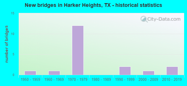
- New bridges - historical statistics
- 11950-1959
- 11960-1969
- 121970-1979
- 21990-1999
- 12000-2009
- 22010-2019


- Bridge Condition - Deck
- 12.5%Very good
- 62.5%Good
- 25.0%Satisfactory

- Bridge Condition - Superstructure
- 12.5%Very good
- 62.5%Good
- 25.0%Satisfactory

- Bridge Condition - Substructure
- 12.5%Very good
- 87.5%Good

- Bridge Condition - Channel
- 33.3%Good
- 55.6%Satisfactory
- 11.1%Fair

- Bridge Condition - Culverts
- 66.7%Good
- 33.3%Satisfactory
Find on map >> Show street view
Structure Number: 90140023103078, Location: 1.9 MI E OF FM 3470 (Lat: 31.070531, Lng: -97.669561), Route carried "on" structure: State highway 2410, Year Built: 1973, Year Reconstructed: 2015, Status: Open, Structure Length: 12.68m (41.60ft), Average Daily Traffic: 15,892 (year 2020), Truck Traffic: 14%, Average Future Daily Traffic: 21,000 (year 2033), Design Load: HS 20, Features Intersected: US 190
Minimum Vertical Clearance: 30+ m (98+ ft), Kilometerpoint: 11.143, Lanes on structure: 6, Lanes under structure: 5, Owner: State Highway Agency, Approaching Roadway Width: 20.7m (67.9ft), Skew: 3 degrees, Material/Design: Prestressed concrete, Design/Construction: Stringer/Multi-beam, Number Of Spans In Main Unit: 2, Number Of Approach Spans: 2, Length of Maximum Span: 37.2m (122.0ft), Curb or Sidewalk Widths: Left: 1.9m (6.2ft), Right: 1.9m (6.2ft), Curb-To-Curb Width: 27.0m (88.6ft), Out-to-Out Width: 31.5m (103.3ft)
Condition: Deck: Good, Superstructure: Satisfactory, Substructure: Good, Operating Rating: 54.4 metric tons, Method Used To Determine Operating Rating: Assigned rating based on Load Factor Design (LFD) reported in metric tons, Inventory Rating: 32.7 metric tons, Method Used To Determine Inventory Rating: Assigned rating based on Load Factor Design (LFD) reported in metric tons, Structural Evaluation: Equal to present minimum criteria, Deck Geometry: Better than present minimum criteria, Underclear: Somewhat better than minimum adequacy, Approach Roadway Alignment: Equal to present desirable criteria, Length Of Structure Improvement: 15.85m (52.00ft), Designated Inspection Frequency: Every 24 months, Inspection Date: April 2021, Bridge Improvement Cost: $1,509,000, Roadway Improvement Cost: $378,000, Total Project Cost: $2,264,000, Deck Structure Type: Concrete Cast-file-Place
Find on map >> Show street view
Structure Number: 90140023103079, Location: 1.0 MI W OF BU 190 (Lat: 31.076047, Lng: -97.653897), Route carried "on" structure: US 190, Year Built: 1973, Status: Open, Structure Length: 7.96m (26.12ft), Average Daily Traffic: 22,340 (year 2013), Truck Traffic: 6%, Average Future Daily Traffic: 31,270 (year 2033), Design Load: HS 20, Features Intersected: FM 3423 (INDIAN TRL)
Minimum Vertical Clearance: 30+ m (98+ ft), Kilometerpoint: 17.852, Lanes on structure: 2, Lanes under structure: 5, Owner: State Highway Agency, Approaching Roadway Width: 12.8m (42.0ft), Material/Design: Prestressed concrete, Design/Construction: Stringer/Multi-beam, Number Of Spans In Main Unit: 3, Length of Maximum Span: 26.5m (86.9ft), Curb-To-Curb Width: 12.8m (42.0ft), Out-to-Out Width: 13.3m (43.6ft)
Condition: Deck: Very good, Superstructure: Good, Substructure: Good, Operating Rating: 68.0 metric tons, Method Used To Determine Operating Rating: Load Factor (LF), Inventory Rating: 35.4 metric tons, Method Used To Determine Inventory Rating: Load Factor (LF), Structural Evaluation: Better than present minimum criteria, Deck Geometry: Equal to present desirable criteria, Underclear: Somewhat better than minimum adequacy, Approach Roadway Alignment: Equal to present desirable criteria, Length Of Structure Improvement: 9.94m (32.61ft), Designated Inspection Frequency: Every 24 months, Inspection Date: April 2021, Bridge Improvement Cost: $1,000,000, Roadway Improvement Cost: $300,000, Total Project Cost: $1,500,000, Deck Structure Type: Concrete Cast-file-Place, Wearing Surface/Protective System: Wearing Surface: Bituminous
Find on map >> Show street view
Structure Number: 9014002310308, Location: 1.0 MI W OF BU 190 (Lat: 31.076219, Lng: -97.654067), Route carried "on" structure: US 190, Year Built: 1973, Status: Open, Structure Length: 7.96m (26.12ft), Average Daily Traffic: 22,340 (year 2013), Truck Traffic: 6%, Average Future Daily Traffic: 31,270 (year 2033), Design Load: HS 20, Features Intersected: FM 3423 (INDIAN TRL)
Minimum Vertical Clearance: 30+ m (98+ ft), Kilometerpoint: 17.852, Lanes on structure: 2, Lanes under structure: 5, Owner: State Highway Agency, Approaching Roadway Width: 12.8m (42.0ft), Material/Design: Prestressed concrete, Design/Construction: Stringer/Multi-beam, Number Of Spans In Main Unit: 3, Length of Maximum Span: 26.5m (86.9ft), Curb-To-Curb Width: 12.8m (42.0ft), Out-to-Out Width: 13.3m (43.6ft)
Condition: Deck: Good, Superstructure: Good, Substructure: Good, Operating Rating: 68.0 metric tons, Method Used To Determine Operating Rating: Load Factor (LF), Inventory Rating: 35.4 metric tons, Method Used To Determine Inventory Rating: Load Factor (LF), Structural Evaluation: Better than present minimum criteria, Deck Geometry: Equal to present desirable criteria, Underclear: High priority of replacement, Approach Roadway Alignment: Equal to present desirable criteria, Length Of Structure Improvement: 9.94m (32.61ft), Designated Inspection Frequency: Every 24 months, Inspection Date: April 2021, Bridge Improvement Cost: $1,000,000, Roadway Improvement Cost: $300,000, Total Project Cost: $1,500,000, Deck Structure Type: Concrete Cast-file-Place, Wearing Surface/Protective System: Wearing Surface: Bituminous
Find on map >> Show street view
Structure Number: 90140023103081, Location: 10.1 MI E OF CORYELL C/L (Lat: 31.075758, Lng: -97.653653), Route carried "on" structure: US 190, Year Built: 1973, Status: Open, Structure Length: 0.76m (2.49ft), Average Daily Traffic: 19,000 (year 2010), Truck Traffic: 11%, Average Future Daily Traffic: 31,470 (year 2030), Design Load: HS 20, Features Intersected: BRANCH OF S NOLAN CREEK, Facility Carried by Structure: FM 3423/INDIAN TRL
Minimum Vertical Clearance: 30+ m (98+ ft), Kilometerpoint: 17.894, Lanes on structure: 3, Owner: State Highway Agency, Approaching Roadway Width: 14.3m (46.9ft), Skew: 4 degrees, Material/Design: Concrete, Design/Construction: Culvert, Number Of Spans In Main Unit: 2, Length of Maximum Span: 2.4m (7.9ft), Curb-To-Curb Width: 17.1m (56.1ft), Out-to-Out Width: 25.1m (82.3ft)
Condition: Channel: Good, Culverts: Good, Operating Rating: 39.9 metric tons, Method Used To Determine Operating Rating: Load Factor (LF), Inventory Rating: 23.6 metric tons, Method Used To Determine Inventory Rating: Load Factor (LF), Structural Evaluation: Somewhat better than minimum adequacy, Deck Geometry: Superior to present desirable criteria, Waterway Adequacy: Better than present minimum criteria, Approach Roadway Alignment: Equal to present desirable criteria, Length Of Structure Improvement: 1.83m (6.00ft), Designated Inspection Frequency: Every 24 months, Inspection Date: April 2021, Bridge Improvement Cost: $200,000, Roadway Improvement Cost: $100,000, Total Project Cost: $400,000, Deck Structure Type: Concrete Cast-file-Place, Wearing Surface/Protective System: Wearing Surface: Bituminous
Find on map >> Show street view
Structure Number: 90140023103082, Location: 10.2 MI E OF CORYELL C/L (Lat: 31.076917, Lng: -97.652778), Route carried "on" structure: US 190, Year Built: 1973, Status: Open, Structure Length: 1.01m (3.31ft), Average Daily Traffic: 17,243 (year 2020), Truck Traffic: 6%, Average Future Daily Traffic: 62,550 (year 2033), Design Load: HS 20, Features Intersected: BRANCH OF S NOLAN CREEK
Minimum Vertical Clearance: 30+ m (98+ ft), Kilometerpoint: 18.004, Lanes on structure: 9, Owner: State Highway Agency, Approaching Roadway Width: 54.0m (177.2ft), Skew: 24 degrees, Material/Design: Concrete, Design/Construction: Culvert, Number Of Spans In Main Unit: 3, Length of Maximum Span: 2.1m (6.9ft)
Condition: Channel: Satisfactory, Culverts: Satisfactory, Operating Rating: 39.9 metric tons, Method Used To Determine Operating Rating: Load Factor (LF), Inventory Rating: 23.6 metric tons, Method Used To Determine Inventory Rating: Load Factor (LF), Structural Evaluation: Somewhat better than minimum adequacy, Waterway Adequacy: Equal to present minimum criteria, Approach Roadway Alignment: Equal to present desirable criteria, Length Of Structure Improvement: 1.83m (6.00ft), Designated Inspection Frequency: Every 24 months, Inspection Date: April 2021, Bridge Improvement Cost: $200,000, Roadway Improvement Cost: $100,000, Total Project Cost: $400,000
Find on map >> Show street view
Structure Number: 90140023103083, Location: 10.3 MI E OF CORYELL C/L (Lat: 31.077469, Lng: -97.651733), Route carried "on" structure: US 190, Year Built: 1973, Status: Open, Structure Length: 0.67m (2.20ft), Average Daily Traffic: 17,243 (year 2020), Truck Traffic: 6%, Average Future Daily Traffic: 62,550 (year 2033), Design Load: HS 20, Features Intersected: BRANCH OF S NOLAN CREEK
Minimum Vertical Clearance: 30+ m (98+ ft), Kilometerpoint: 18.157, Lanes on structure: 10, Owner: State Highway Agency, Approaching Roadway Width: 61.0m (200.1ft), Skew: 20 degrees, Material/Design: Concrete, Design/Construction: Culvert, Number Of Spans In Main Unit: 2, Length of Maximum Span: 3.0m (9.8ft)
Condition: Channel: Satisfactory, Culverts: Good, Operating Rating: 39.9 metric tons, Method Used To Determine Operating Rating: Load Factor (LF), Inventory Rating: 23.6 metric tons, Method Used To Determine Inventory Rating: Load Factor (LF), Structural Evaluation: Somewhat better than minimum adequacy, Waterway Adequacy: Equal to present minimum criteria, Approach Roadway Alignment: Equal to present desirable criteria, Length Of Structure Improvement: 1.83m (6.00ft), Designated Inspection Frequency: Every 24 months, Inspection Date: April 2021, Bridge Improvement Cost: $200,000, Roadway Improvement Cost: $100,000, Total Project Cost: $400,000
Find on map >> Show street view
Structure Number: 90140023103096, Location: 0.83 MI E OF FM 3423 (Lat: 31.082586, Lng: -97.642739), Route carried "on" structure: State highway 190, Year Built: 1976, Status: Open, Structure Length: 13.59m (44.59ft), Average Daily Traffic: 10,690 (year 2013), Truck Traffic: 2%, Average Future Daily Traffic: 14,970 (year 2033), Design Load: HS 20, Features Intersected: US 190, Facility Carried by Structure: OLD NOLAN RD
Minimum Vertical Clearance: 30+ m (98+ ft), Kilometerpoint: 14.642, Lanes on structure: 2, Lanes under structure: 4, Owner: State Highway Agency, Approaching Roadway Width: 12.8m (42.0ft), Skew: 9 degrees, Material/Design: Steel continuous, Design/Construction: Stringer/Multi-beam, Number Of Spans In Main Unit: 4, Length of Maximum Span: 43.3m (142.1ft), Curb-To-Curb Width: 12.8m (42.0ft), Out-to-Out Width: 13.3m (43.6ft)
Condition: Deck: Satisfactory, Superstructure: Satisfactory, Substructure: Good, Operating Rating: 44.4 metric tons, Method Used To Determine Operating Rating: Assigned ratings based on Allowable Stress Design (ASD) reported in metric tons, Inventory Rating: 32.7 metric tons, Method Used To Determine Inventory Rating: Assigned ratings based on Allowable Stress Design (ASD) reported in metric tons, Structural Evaluation: Equal to present minimum criteria, Deck Geometry: Equal to present desirable criteria, Underclear: Equal to present minimum criteria, Approach Roadway Alignment: Equal to present desirable criteria, Length Of Structure Improvement: 16.98m (55.71ft), Designated Inspection Frequency: Every 24 months, Inspection Date: April 2021, Bridge Improvement Cost: $1,700,000, Roadway Improvement Cost: $500,000, Total Project Cost: $2,500,000, Deck Structure Type: Concrete Cast-file-Place
Find on map >> Show street view
Structure Number: 90140023103388, Location: 1.8 MI E of FM 3470 (Lat: 31.070361, Lng: -97.669600), Route carried "on" structure: State highway 2410, Year Built: 2013, Status: Open, Structure Length: 12.86m (42.19ft), Average Daily Traffic: 1,000 (year 2011), Truck Traffic: 8%, Average Future Daily Traffic: 1,500 (year 2031), Design Load: HL 93, Features Intersected: US 190 ML
Minimum Vertical Clearance: 30+ m (98+ ft), Kilometerpoint: 11.143, Lanes on structure: 1, Lanes under structure: 5, Owner: State Highway Agency, Approaching Roadway Width: 8.5m (27.9ft), Skew: 3 degrees, Material/Design: Prestressed concrete, Design/Construction: Stringer/Multi-beam, Number Of Spans In Main Unit: 2, Number Of Approach Spans: 2, Length of Maximum Span: 37.8m (124.0ft), Curb-To-Curb Width: 8.5m (27.9ft), Out-to-Out Width: 9.2m (30.2ft)
Condition: Deck: Good, Superstructure: Very good, Substructure: Very good, Operating Rating: 54.4 metric tons, Method Used To Determine Operating Rating: Assigned ratings based on Load and Resistance Factor Design (LRFD) reported in metric tons, Inventory Rating: 32.7 metric tons, Method Used To Determine Inventory Rating: Assigned ratings based on Load and Resistance Factor Design (LRFD) reported in metric tons, Structural Evaluation: Equal to present desirable criteria, Deck Geometry: Somewhat better than minimum adequacy, Underclear: Equal to present minimum criteria, Approach Roadway Alignment: Equal to present minimum criteria, Designated Inspection Frequency: Every 24 months, Inspection Date: April 2021, Deck Structure Type: Concrete Precast Panels
Find on map >> Show street view
Structure Number: 90140203801001, Location: 0.50 MI SW OF IH 35 (Lat: 30.910692, Lng: -97.548228), Route carried "on" structure: State highway 2115, Year Built: 1955, Status: Open, Structure Length: 0.76m (2.49ft), Average Daily Traffic: 533 (year 2020), Truck Traffic: 31%, Average Future Daily Traffic: 670 (year 2035), Features Intersected: SALADO CREEK BRANCH
Minimum Vertical Clearance: 30+ m (98+ ft), Kilometerpoint: 17.027, Lanes on structure: 2, Owner: State Highway Agency, Approaching Roadway Width: 6.7m (22.0ft), Skew: 3 degrees, Material/Design: Concrete, Design/Construction: Culvert, Number Of Spans In Main Unit: 2, Length of Maximum Span: 3.0m (9.8ft)
Condition: Channel: Satisfactory, Culverts: Satisfactory, Operating Rating: 39.9 metric tons, Method Used To Determine Operating Rating: Load Factor (LF), Inventory Rating: 23.6 metric tons, Method Used To Determine Inventory Rating: Load Factor (LF), Structural Evaluation: Equal to present minimum criteria, Waterway Adequacy: Equal to present minimum criteria, Approach Roadway Alignment: Somewhat better than minimum adequacy, Length Of Structure Improvement: 1.83m (6.00ft), Designated Inspection Frequency: Every 24 months, Inspection Date: March 2021, Bridge Improvement Cost: $174,000, Roadway Improvement Cost: $43,000, Total Project Cost: $261,000
Find on map >> Show street view
Structure Number: 90140230402011, Location: 0.25 MI W OF FM 3481 (Lat: 31.057669, Lng: -97.658483), Route carried "on" structure: State highway 2410, Year Built: 2002, Status: Open, Structure Length: 1.83m (6.00ft), Average Daily Traffic: 36,870 (year 2020), Truck Traffic: 14%, Average Future Daily Traffic: 36,970 (year 2033), Design Load: HS 20, Features Intersected: SPROTT BRANCH
Minimum Vertical Clearance: 30+ m (98+ ft), Kilometerpoint: 13.052, Lanes on structure: 5, Owner: State Highway Agency, Approaching Roadway Width: 20.4m (66.9ft), Skew: 1 degrees, Material/Design: Concrete, Design/Construction: Culvert, Number Of Spans In Main Unit: 6, Length of Maximum Span: 2.4m (7.9ft), Curb or Sidewalk Widths: Left: 1.8m (5.9ft), Right: 1.8m (5.9ft)
Condition: Channel: Good, Culverts: Good, Operating Rating: 54.4 metric tons, Method Used To Determine Operating Rating: Assigned ratings based on Load and Resistance Factor Design (LRFD) reported in metric tons, Inventory Rating: 32.7 metric tons, Method Used To Determine Inventory Rating: Assigned ratings based on Load and Resistance Factor Design (LRFD) reported in metric tons, Structural Evaluation: Better than present minimum criteria, Waterway Adequacy: Equal to present minimum criteria, Approach Roadway Alignment: Equal to present desirable criteria, Designated Inspection Frequency: Every 24 months, Inspection Date: April 2021
Find on map >> Show street view
Structure Number: 90140269601001, Location: 0.05 Mi N of BUS 190 (Lat: 31.086700, Lng: -97.648567), Route carried "on" structure: State highway 3219, Year Built: 1974, Status: Open, Structure Length: 6.10m (20.01ft), Average Daily Traffic: 6,252 (year 2020), Truck Traffic: 11%, Average Future Daily Traffic: 7,550 (year 2033), Design Load: HS 20, Features Intersected: SOUTH NOLAN CREEK
Minimum Vertical Clearance: 30+ m (98+ ft), Kilometerpoint: 10.147, Lanes on structure: 2, Owner: State Highway Agency, Approaching Roadway Width: 10.4m (34.1ft), Material/Design: Concrete, Design/Construction: Stringer/Multi-beam, Number Of Spans In Main Unit: 5, Length of Maximum Span: 12.2m (40.0ft), Curb-To-Curb Width: 10.4m (34.1ft), Out-to-Out Width: 11.1m (36.4ft)
Condition: Deck: Satisfactory, Superstructure: Good, Substructure: Good, Channel: Satisfactory, Operating Rating: 68.0 metric tons, Method Used To Determine Operating Rating: Load Factor (LF), Inventory Rating: 40.8 metric tons, Method Used To Determine Inventory Rating: Load Factor (LF), Structural Evaluation: Better than present minimum criteria, Deck Geometry: Meets minimum limits, Waterway Adequacy: Equal to present desirable criteria, Approach Roadway Alignment: Equal to present desirable criteria, Length Of Structure Improvement: 8.23m (27.00ft), Designated Inspection Frequency: Every 24 months, Inspection Date: April 2021, Bridge Improvement Cost: $783,000, Roadway Improvement Cost: $195,000, Total Project Cost: $1,175,000, Deck Structure Type: Concrete Cast-file-Place
Find on map >> Show street view
Structure Number: 90140340901002, Location: 0.40 MI S OF INT FM 2410 (Lat: 31.051561, Lng: -97.655672), Route carried "on" structure: State highway 3481, Year Built: 1997, Status: Open, Structure Length: 1.95m (6.40ft), Average Daily Traffic: 15,187 (year 2019), Truck Traffic: 3%, Average Future Daily Traffic: 12,960 (year 2033), Design Load: HS 20, Features Intersected: TRIB TRIMMIER CREEK
Minimum Vertical Clearance: 30+ m (98+ ft), Kilometerpoint: 0.542, Lanes on structure: 3, Owner: State Highway Agency, Approaching Roadway Width: 14.0m (45.9ft), Material/Design: Concrete, Design/Construction: Culvert, Number Of Spans In Main Unit: 6, Length of Maximum Span: 3.0m (9.8ft)
Condition: Channel: Good, Culverts: Good, Operating Rating: 39.9 metric tons, Method Used To Determine Operating Rating: Load Factor (LF), Inventory Rating: 23.6 metric tons, Method Used To Determine Inventory Rating: Load Factor (LF), Structural Evaluation: Somewhat better than minimum adequacy, Waterway Adequacy: Superior to present desirable criteria, Approach Roadway Alignment: Equal to present desirable criteria, Length Of Structure Improvement: 2.74m (8.99ft), Designated Inspection Frequency: Every 48 months, Inspection Date: April 2021, Bridge Improvement Cost: $261,000, Roadway Improvement Cost: $65,000, Total Project Cost: $392,000
Find on map >> Show street view
Structure Number: 90140AA0572001, Location: 0.50 MI W OF FM 3481 (Lat: 31.035117, Lng: -97.664828), Route carried "on" structure: County highway , Year Built: 1968, Status: Open, Structure Length: 3.75m (12.30ft), Average Daily Traffic: 4,577 (year 2020), Truck Traffic: 2%, Average Future Daily Traffic: 1,600 (year 2033), Features Intersected: TRIMMIER CRK #5, Facility Carried by Structure: CHAPARRAL RD
Minimum Vertical Clearance: 30+ m (98+ ft), Kilometerpoint: 9.656, Lanes on structure: 2, Owner: County Highway Agency, Approaching Roadway Width: 6.1m (20.0ft), Material/Design: Concrete, Design/Construction: Stringer/Multi-beam, Number Of Spans In Main Unit: 4, Length of Maximum Span: 9.1m (29.9ft), Curb-To-Curb Width: 7.0m (23.0ft), Out-to-Out Width: 7.5m (24.6ft)
Condition: Deck: Good, Superstructure: Good, Substructure: Good, Channel: Satisfactory, Operating Rating: 32.7 metric tons, Method Used To Determine Operating Rating: Field evaluation and documented engineering judgment, Inventory Rating: 24.5 metric tons, Method Used To Determine Inventory Rating: Field evaluation and documented engineering judgment, Structural Evaluation: Equal to present minimum criteria, Deck Geometry: High priority of replacement, Waterway Adequacy: Meets minimum limits, Approach Roadway Alignment: High priority of corrective action, Length Of Structure Improvement: 4.57m (14.99ft), Designated Inspection Frequency: Every 24 months, Inspection Date: November 2021, Bridge Improvement Cost: $419,000, Roadway Improvement Cost: $104,000, Total Project Cost: $523,000, Deck Structure Type: Concrete Cast-file-Place, Wearing Surface/Protective System: Wearing Surface: Bituminous
Find on map >> Show street view
Structure Number: 90140E00466001, Location: 0.45 MI N OF US 190 BU (Lat: 31.098992, Lng: -97.671667), Route carried "on" structure: City street , Year Built: 1993, Status: Open, Structure Length: 7.32m (24.02ft), Average Daily Traffic: 7,221 (year 2018), Truck Traffic: 2%, Average Future Daily Traffic: 3,500 (year 2033), Design Load: HS 20, Features Intersected: S NOLAN CRK #1 HRK, Facility Carried by Structure: ROY REYNOLDS DR
Minimum Vertical Clearance: 30+ m (98+ ft), Kilometerpoint: 0.724, Lanes on structure: 4, Owner: City or Municipal Highway Agency, Approaching Roadway Width: 15.2m (49.9ft), Material/Design: Prestressed concrete, Design/Construction: Stringer/Multi-beam, Number Of Spans In Main Unit: 3, Length of Maximum Span: 24.4m (80.1ft), Curb-To-Curb Width: 15.6m (51.2ft), Out-to-Out Width: 16.5m (54.1ft)
Condition: Deck: Good, Superstructure: Good, Substructure: Good, Channel: Fair, Operating Rating: 54.4 metric tons, Method Used To Determine Operating Rating: Assigned rating based on Load Factor Design (LFD) reported in metric tons, Inventory Rating: 32.7 metric tons, Method Used To Determine Inventory Rating: Assigned rating based on Load Factor Design (LFD) reported in metric tons, Structural Evaluation: Better than present minimum criteria, Deck Geometry: Meets minimum limits, Waterway Adequacy: Superior to present desirable criteria, Approach Roadway Alignment: Equal to present desirable criteria, Length Of Structure Improvement: 9.24m (30.31ft), Designated Inspection Frequency: Every 24 months, Inspection Date: November 2021, Bridge Improvement Cost: $845,000, Roadway Improvement Cost: $211,000, Total Project Cost: $1,056,000, Deck Structure Type: Concrete Precast Panels
Find on map >> Show street view
Structure Number: 90140023103078, Location: 1.9 MI E OF FM 3470 (Lat: 31.070531, Lng: -97.669561), Route carried "under" structure: US 190, Year Built: 1973, Structure Length: 0. m, Average Daily Traffic: 38,720 (year 2013), Truck Traffic: 6%, Features Intersected: US 190, Facility Carried by Structure: FM 2410
Minimum Vertical Clearance: 5.41m (17.75ft), Kilometerpoint: 16.238, Lanes on structure: 5, Lanes under structure: 5, Material/Design: Prestressed concrete, Design/Construction: Stringer/Multi-beam, Length of Maximum Span: 37.2m (122.0ft)
Find on map >> Show street view
Structure Number: 90140023103079, Location: 1.0 MI W OF BU 190 (Lat: 31.076047, Lng: -97.653897), Route carried "under" structure: State highway 3423, Year Built: 1973, Structure Length: 0. m, Average Daily Traffic: 15,060 (year 2013), Truck Traffic: 1%, Features Intersected: FM 3423 (INDIAN TRL), Facility Carried by Structure: US 190 EB ML
Minimum Vertical Clearance: 5.18m (16.99ft), Kilometerpoint: 17.852, Lanes on structure: 2, Lanes under structure: 5, Material/Design: Prestressed concrete, Design/Construction: Stringer/Multi-beam, Length of Maximum Span: 26.5m (86.9ft)
Find on map >> Show street view
Structure Number: 9014002310308, Location: 1.0 MI W OF BU 190 (Lat: 31.076219, Lng: -97.654067), Route carried "under" structure: State highway 3423, Year Built: 1973, Structure Length: 0. m, Average Daily Traffic: 15,060 (year 2013), Truck Traffic: 1%, Features Intersected: FM 3423 (INDIAN TRL), Facility Carried by Structure: US 190 WB ML
Minimum Vertical Clearance: 5.18m (16.99ft), Kilometerpoint: 0.003, Lanes on structure: 2, Lanes under structure: 5, Material/Design: Prestressed concrete, Design/Construction: Stringer/Multi-beam, Length of Maximum Span: 26.5m (86.9ft)
Find on map >> Show street view
Structure Number: 90140023103096, Location: 0.83 MI E OF FM 3423 (Lat: 31.082586, Lng: -97.642739), Route carried "under" structure: US 190, Year Built: 1976, Structure Length: 0. m, Average Daily Traffic: 52,280 (year 2013), Truck Traffic: 6%, Features Intersected: US 190, Facility Carried by Structure: OLD NOLAN RD
Minimum Vertical Clearance: 5.28m (17.32ft), Kilometerpoint: 19.183, Lanes on structure: 2, Lanes under structure: 4, Material/Design: Steel continuous, Design/Construction: Stringer/Multi-beam, Length of Maximum Span: 43.3m (142.1ft)
Find on map >> Show street view
Structure Number: 90140023103388, Location: 1.8 MI E of FM 3470 (Lat: 31.070361, Lng: -97.669600), Route carried "under" structure: US 190, Year Built: 2013, Structure Length: 0. m, Average Daily Traffic: 36,940 (year 2010), Truck Traffic: 8%, Features Intersected: US 190 ML, Facility Carried by Structure: FM 2410 TA
Minimum Vertical Clearance: 5.05m (16.57ft), Kilometerpoint: 16.174, Lanes on structure: 1, Lanes under structure: 5, Material/Design: Prestressed concrete, Design/Construction: Stringer/Multi-beam, Length of Maximum Span: 37.8m (124.0ft)