Bridge Statistics for Gulf Hills, Mississippi (MS)
Condition, Traffic, Stress, Structural Evaluation, Project Costs
- National Bridge Inventory (NBI) Statistics
- 14Number of bridges
- 128ft / 39.2mTotal length
- $1,000,000Total costs
- 139,370Total average daily traffic
- 18,216Total average daily truck traffic
- National Bridge Inventory (NBI) Registered Bridges for Gulf Hills
- No street view available for this location
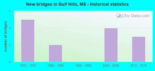
- New bridges - historical statistics
- 51970-1979
- 21980-1989
- 42000-2009
- 32010-2019


- Bridge Condition - Deck
- 20.0%Very good
- 70.0%Good
- 10.0%Satisfactory

- Bridge Condition - Superstructure
- 80.0%Good
- 20.0%Satisfactory

- Bridge Condition - Substructure
- 10.0%Very good
- 70.0%Good
- 10.0%Satisfactory
- 10.0%Fair

- Bridge Condition - Channel
- 11.1%Excellent
- 66.7%Very good
- 11.1%Good
- 11.1%Satisfactory

- Bridge Condition - Culverts
- 50.0%Excellent
- 50.0%Good
Find on map >> Show street view
Structure Number: 11000100300515A, Location: I 10 OVER SR 609 (Lat: 30.454389, Lng: -88.842483), Route carried "on" structure: Interstate 10, Year Built: 1970, Year Reconstructed: 2011, Status: Open, Structure Length: 9.14m (29.99ft), Average Daily Traffic: 35,000 (year 2020), Truck Traffic: 15%, Average Future Daily Traffic: 37,500 (year 2040), Design Load: HS 20+Mod, Features Intersected: SR 609
Minimum Vertical Clearance: 30+ m (98+ ft), Kilometerpoint: 43.914, Lanes on structure: 3, Lanes under structure: 4, Base Highway Network: Yes (Inventory Route: 1, Subroute: 1), Owner: State Highway Agency, Approaching Roadway Width: 18.1m (59.4ft), Skew: 1 degrees, Material/Design: Prestressed concrete, Design/Construction: Stringer/Multi-beam, Number Of Spans In Main Unit: 2, Number Of Approach Spans: 2, Length of Maximum Span: 24.4m (80.1ft), Curb-To-Curb Width: 18.1m (59.4ft), Out-to-Out Width: 18.9m (62.0ft)
Condition: Deck: Good, Superstructure: Good, Substructure: Good, Operating Rating: 59.6 metric tons, Method Used To Determine Operating Rating: Load Factor (LF), Inventory Rating: 31.3 metric tons, Method Used To Determine Inventory Rating: Load Factor (LF), Structural Evaluation: Better than present minimum criteria, Deck Geometry: Better than present minimum criteria, Underclear: Better than present minimum criteria, Approach Roadway Alignment: Equal to present desirable criteria, Designated Inspection Frequency: Every 24 months, Inspection Date: November 2021, Deck Structure Type: Concrete Cast-file-Place
Find on map >> Show street view
Structure Number: 11000100300553A, Location: 3.8 MI E SR 609 (Lat: 30.458583, Lng: -88.779592), Route carried "on" structure: Interstate 10, Year Built: 1970, Status: Open, Structure Length: 7.92m (25.98ft), Average Daily Traffic: 34,500 (year 2020), Truck Traffic: 15%, Average Future Daily Traffic: 45,500 (year 2040), Design Load: HS 20+Mod, Features Intersected: OLD FORT BAYOU ROAD
Minimum Vertical Clearance: 30+ m (98+ ft), Kilometerpoint: 37.800, Lanes on structure: 2, Lanes under structure: 2, Base Highway Network: Yes (Inventory Route: 1, Subroute: 1), Owner: State Highway Agency, Approaching Roadway Width: 12.8m (42.0ft), Skew: 2 degrees, Material/Design: Concrete continuous, Design/Construction: Box Beam or Girders - Single/Spread, Number Of Spans In Main Unit: 1, Number Of Approach Spans: 2, Length of Maximum Span: 33.5m (109.9ft), Curb-To-Curb Width: 12.3m (40.4ft), Out-to-Out Width: 13.4m (44.0ft)
Condition: Deck: Good, Superstructure: Good, Substructure: Good, Inventory Rating: 65.7 metric tons, Method Used To Determine Inventory Rating: Load Factor (LF), Structural Evaluation: Better than present minimum criteria, Deck Geometry: Better than present minimum criteria, Underclear: Better than present minimum criteria, Approach Roadway Alignment: Equal to present desirable criteria, Designated Inspection Frequency: Every 24 months, Inspection Date: November 2021, Deck Structure Type: Concrete Cast-file-Place
Find on map >> Show street view
Structure Number: 11000100300553B, Location: 3.8 MI E SR 609 (Lat: 30.458442, Lng: -88.780856), Route carried "on" structure: Interstate 10, Year Built: 1970, Status: Open, Structure Length: 7.92m (25.98ft), Average Daily Traffic: 34,500 (year 2020), Truck Traffic: 15%, Average Future Daily Traffic: 45,500 (year 2040), Design Load: HS 20+Mod, Features Intersected: OLD FORT BAYOU ROAD
Minimum Vertical Clearance: 30+ m (98+ ft), Kilometerpoint: 9.907, Lanes on structure: 2, Lanes under structure: 2, Base Highway Network: Yes (Inventory Route: 1, Subroute: 1), Owner: State Highway Agency, Approaching Roadway Width: 12.8m (42.0ft), Skew: 2 degrees, Material/Design: Concrete continuous, Design/Construction: Box Beam or Girders - Single/Spread, Number Of Spans In Main Unit: 1, Number Of Approach Spans: 2, Length of Maximum Span: 33.5m (109.9ft), Curb-To-Curb Width: 12.3m (40.4ft), Out-to-Out Width: 13.4m (44.0ft)
Condition: Deck: Good, Superstructure: Good, Substructure: Very good, Inventory Rating: 65.7 metric tons, Method Used To Determine Inventory Rating: Load Factor (LF), Structural Evaluation: Better than present minimum criteria, Deck Geometry: Better than present minimum criteria, Underclear: Better than present minimum criteria, Approach Roadway Alignment: Equal to present desirable criteria, Designated Inspection Frequency: Every 24 months, Inspection Date: November 2021, Deck Structure Type: Concrete Cast-file-Place
Find on map >> Show street view
Structure Number: SA3000000000076, Location: SEC 27 T 6S R 8W (Lat: 30.498244, Lng: -88.770119), Route carried "on" structure: County highway 8046, Year Built: 1988, Status: Open, Structure Length: 1.74m (5.71ft), Average Daily Traffic: 120 (year 2020), Truck Traffic: 1%, Average Future Daily Traffic: 132 (year 2040), Design Load: H 15, Features Intersected: LIVE STREAM, Facility Carried by Structure: ANTIOCH ROAD
Minimum Vertical Clearance: 30+ m (98+ ft), Kilometerpoint: 2.414, Lanes on structure: 2, Owner: County Highway Agency, Approaching Roadway Width: 6.2m (20.3ft), Material/Design: Concrete, Design/Construction: Channel Beam, Number Of Spans In Main Unit: 3, Length of Maximum Span: 5.8m (19.0ft), Curb or Sidewalk Widths: Left: 0.2m (0.7ft), Right: 0.2m (0.7ft), Curb-To-Curb Width: 7.1m (23.3ft), Out-to-Out Width: 7.5m (24.6ft)
Condition: Deck: Good, Superstructure: Good, Substructure: Good, Channel: Good, Operating Rating: 54.9 metric tons, Method Used To Determine Operating Rating: Load Factor (LF), Inventory Rating: 32.9 metric tons, Method Used To Determine Inventory Rating: Load Factor (LF), Structural Evaluation: Better than present minimum criteria, Deck Geometry: Meets minimum limits, Waterway Adequacy: Equal to present desirable criteria, Approach Roadway Alignment: Equal to present minimum criteria, Length Of Structure Improvement: 3.05m (10.01ft), Designated Inspection Frequency: Every 24 months, Inspection Date: December 2020, Bridge Improvement Cost: $100,000, Roadway Improvement Cost: $100,000, Total Project Cost: $200,000, Deck Structure Type: Concrete Precast Panels, Wearing Surface/Protective System: Wearing Surface: Monolithic Concrete
Find on map >> Show street view
Structure Number: SA3000000000114, Location: SEC 3 T 7S R 8W B (Lat: 30.464908, Lng: -88.771681), Route carried "on" structure: County highway 2107, Year Built: 2006, Status: Open, Structure Length: 1.74m (5.71ft), Average Daily Traffic: 1,400 (year 2021), Truck Traffic: 10%, Average Future Daily Traffic: 2,000 (year 2041), Design Load: HS 20, Features Intersected: RELIEF, Facility Carried by Structure: OLD FORT BAYOU
Minimum Vertical Clearance: 30+ m (98+ ft), Kilometerpoint: 7.724, Lanes on structure: 2, Owner: County Highway Agency, Approaching Roadway Width: 8.1m (26.6ft), Material/Design: Concrete, Design/Construction: Channel Beam, Number Of Spans In Main Unit: 3, Length of Maximum Span: 5.8m (19.0ft), Curb-To-Curb Width: 8.1m (26.6ft), Out-to-Out Width: 8.6m (28.2ft)
Condition: Deck: Good, Superstructure: Good, Substructure: Good, Channel: Very good, Operating Rating: 90.2 metric tons, Method Used To Determine Operating Rating: Load Factor (LF), Inventory Rating: 53.9 metric tons, Method Used To Determine Inventory Rating: Load Factor (LF), Structural Evaluation: Better than present minimum criteria, Deck Geometry: Meets minimum limits, Waterway Adequacy: Equal to present desirable criteria, Approach Roadway Alignment: Equal to present desirable criteria, Designated Inspection Frequency: Every 24 months, Inspection Date: November 2021, Deck Structure Type: Concrete Precast Panels
Find on map >> Show street view
Structure Number: SA3000000000126, Location: SEC 12 T 7S R 9W (Lat: 30.443203, Lng: -88.842361), Route carried "on" structure: County highway 2316, Year Built: 1989, Status: Open, Structure Length: 2.10m (6.89ft), Average Daily Traffic: 1,800 (year 2020), Truck Traffic: 10%, Average Future Daily Traffic: 2,500 (year 2040), Design Load: HS 20, Features Intersected: BAYOU PORTEAUX, Facility Carried by Structure: LEMOYNE BLVD.
Minimum Vertical Clearance: 30+ m (98+ ft), Kilometerpoint: 4.023, Lanes on structure: 2, Owner: County Highway Agency, Approaching Roadway Width: 9.1m (29.9ft), Material/Design: Concrete, Design/Construction: Channel Beam, Number Of Spans In Main Unit: 3, Length of Maximum Span: 9.4m (30.8ft), Curb-To-Curb Width: 8.2m (26.9ft), Out-to-Out Width: 8.6m (28.2ft)
Condition: Deck: Good, Superstructure: Satisfactory, Substructure: Good, Channel: Very good, Operating Rating: 75.5 metric tons, Method Used To Determine Operating Rating: Load Factor (LF), Inventory Rating: 45.4 metric tons, Method Used To Determine Inventory Rating: Load Factor (LF), Structural Evaluation: Equal to present minimum criteria, Deck Geometry: Meets minimum limits, Waterway Adequacy: Better than present minimum criteria, Approach Roadway Alignment: Meets minimum limits, Designated Inspection Frequency: Every 24 months, Inspection Date: March 2020, Deck Structure Type: Concrete Cast-file-Place
Find on map >> Show street view
Structure Number: SA300000000017, Location: SEC 16 T 7S R 8W (Lat: 30.436467, Lng: -88.797667), Route carried "on" structure: County highway 11, Year Built: 2007, Status: Open, Structure Length: 2.10m (6.89ft), Average Daily Traffic: 2,000 (year 2021), Truck Traffic: 20%, Average Future Daily Traffic: 3,000 (year 2041), Design Load: HS 20, Features Intersected: DRAINAGE TO BAYOU TALLA, Facility Carried by Structure: YELLOW JACKET BLVD
Minimum Vertical Clearance: 30+ m (98+ ft), Kilometerpoint: 0.965, Lanes on structure: 2, Owner: County Highway Agency, Approaching Roadway Width: 8.1m (26.6ft), Material/Design: Concrete, Design/Construction: Channel Beam, Number Of Spans In Main Unit: 3, Length of Maximum Span: 9.4m (30.8ft), Curb-To-Curb Width: 9.7m (31.8ft), Out-to-Out Width: 10.4m (34.1ft)
Condition: Deck: Good, Superstructure: Good, Substructure: Satisfactory, Channel: Very good, Operating Rating: 63.1 metric tons, Method Used To Determine Operating Rating: Load Factor (LF), Inventory Rating: 37.9 metric tons, Method Used To Determine Inventory Rating: Load Factor (LF), Structural Evaluation: Equal to present minimum criteria, Deck Geometry: Somewhat better than minimum adequacy, Waterway Adequacy: Equal to present desirable criteria, Approach Roadway Alignment: Equal to present desirable criteria, Length Of Structure Improvement: 2.94m (9.65ft), Designated Inspection Frequency: Every 24 months, Inspection Date: December 2021, Bridge Improvement Cost: $500,000, Roadway Improvement Cost: $100,000, Total Project Cost: $800,000 ( Estimate for 2021), Deck Structure Type: Concrete Precast Panels
Find on map >> Show street view
Structure Number: SA3000000000184, Location: SEC 10 T 7S R 8W (Lat: 30.449928, Lng: -88.782806), Route carried "on" structure: County highway 2090, Year Built: 2000, Status: Open, Structure Length: 1.16m (3.81ft), Average Daily Traffic: 100 (year 2020), Average Future Daily Traffic: 200 (year 2040), Design Load: HS 15, Features Intersected: BRANCH, Facility Carried by Structure: EGLIN ROAD
Minimum Vertical Clearance: 30+ m (98+ ft), Kilometerpoint: 0.400, Lanes on structure: 2, Owner: County Highway Agency, Approaching Roadway Width: 5.8m (19.0ft), Material/Design: Concrete, Design/Construction: Channel Beam, Number Of Spans In Main Unit: 2, Length of Maximum Span: 5.8m (19.0ft), Curb or Sidewalk Widths: Left: 0.2m (0.7ft), Right: 0.2m (0.7ft), Curb-To-Curb Width: 7.1m (23.3ft), Out-to-Out Width: 7.5m (24.6ft)
Condition: Deck: Satisfactory, Superstructure: Satisfactory, Substructure: Fair, Channel: Satisfactory, Operating Rating: 84.9 metric tons, Method Used To Determine Operating Rating: Load Factor (LF) rating reported by rating factor (RF) method using MS18 loading, Inventory Rating: 50.9 metric tons, Method Used To Determine Inventory Rating: Load Factor (LF) rating reported by rating factor (RF) method using MS18 loading, Structural Evaluation: Somewhat better than minimum adequacy, Deck Geometry: Somewhat better than minimum adequacy, Waterway Adequacy: Equal to present desirable criteria, Approach Roadway Alignment: Equal to present desirable criteria, Designated Inspection Frequency: Every 24 months, Inspection Date: December 2020, Deck Structure Type: Concrete Precast Panels, Wearing Surface/Protective System: Wearing Surface: Monolithic Concrete
Find on map >> Show street view
Structure Number: SA3000000000203, Location: SEC 9 T 7S R 8W (Lat: 30.452828, Lng: -88.782647), Route carried "on" structure: County highway , Year Built: 2014, Status: Open, Structure Length: 0.61m (2.00ft), Average Daily Traffic: 100 (year 2021), Truck Traffic: 10%, Average Future Daily Traffic: 150 (year 2041), Design Load: HS 20, Features Intersected: BRANCH OF BAYOU TALLA, Facility Carried by Structure: EGLIN ROAD
Minimum Vertical Clearance: 30+ m (98+ ft), Kilometerpoint: 8.440, Lanes on structure: 2, Toll: On toll road, Owner: County Highway Agency, Approaching Roadway Width: 9.1m (29.9ft), Material/Design: Concrete, Design/Construction: Culvert, Number Of Spans In Main Unit: 2, Length of Maximum Span: 2.4m (7.9ft)
Condition: Channel: Very good, Culverts: Good, Operating Rating: 54.6 metric tons, Method Used To Determine Operating Rating: Load Factor (LF), Inventory Rating: 32.7 metric tons, Method Used To Determine Inventory Rating: Load Factor (LF), Structural Evaluation: Better than present minimum criteria, Waterway Adequacy: Better than present minimum criteria, Approach Roadway Alignment: Equal to present desirable criteria, Designated Inspection Frequency: Every 24 months, Inspection Date: March 2021
Find on map >> Show street view
Structure Number: SA3000000000205, Location: SEC 12 T 7S R 9W (Lat: 30.445208, Lng: -88.833572), Route carried "on" structure: City street , Year Built: 2018, Status: Open, Structure Length: 1.16m (3.81ft), Average Daily Traffic: 50 (year 2021), Truck Traffic: 10%, Average Future Daily Traffic: 75 (year 2041), Design Load: HL 93, Features Intersected: BRANCH OF BAYOU PORTEAUX, Facility Carried by Structure: ISAAC WILLIAMS
Minimum Vertical Clearance: 30+ m (98+ ft), Kilometerpoint: 2.020, Lanes on structure: 2, Owner: County Highway Agency, Approaching Roadway Width: 9.1m (29.9ft), Material/Design: Concrete, Design/Construction: Channel Beam, Number Of Spans In Main Unit: 2, Length of Maximum Span: 5.8m (19.0ft), Curb or Sidewalk Widths: Left: 0.2m (0.7ft), Right: 0.2m (0.7ft), Curb-To-Curb Width: 7.3m (24.0ft), Out-to-Out Width: 7.8m (25.6ft)
Condition: Deck: Very good, Superstructure: Good, Substructure: Good, Channel: Excellent, Operating Rating: 44.7 metric tons, Method Used To Determine Operating Rating: Load and Resistance Factor Rating (LRFR) rating reported by rating factor(RF) method using HL-93 loadings, Inventory Rating: 34.3 metric tons, Method Used To Determine Inventory Rating: Load and Resistance Factor Rating (LRFR) rating reported by rating factor(RF) method using HL-93 loadings, Structural Evaluation: Better than present minimum criteria, Deck Geometry: Equal to present minimum criteria, Waterway Adequacy: Superior to present desirable criteria, Approach Roadway Alignment: Equal to present desirable criteria, Designated Inspection Frequency: Every 24 months, Inspection Date: March 2021, Deck Structure Type: Concrete Precast Panels, Wearing Surface/Protective System: Wearing Surface: Monolithic Concrete
Find on map >> Show street view
Structure Number: SA3000000000209, Location: SEC 17 T 7S R 8W (Lat: 30.441064, Lng: -88.806153), Route carried "on" structure: County highway 2107, Year Built: 2019, Status: Open, Structure Length: 0.75m (2.46ft), Average Daily Traffic: 7,000 (year 2021), Truck Traffic: 10%, Average Future Daily Traffic: 8,000 (year 2041), Design Load: HS 20+Mod, Features Intersected: BAYOU TALLA, Facility Carried by Structure: OLD FORT BAYOU RD
Minimum Vertical Clearance: 30+ m (98+ ft), Kilometerpoint: 2.414, Lanes on structure: 2, Owner: County Highway Agency, Approaching Roadway Width: 11.0m (36.1ft), Material/Design: Concrete, Design/Construction: Culvert, Number Of Spans In Main Unit: 2, Length of Maximum Span: 3.7m (12.1ft)
Condition: Channel: Very good, Culverts: Excellent, Operating Rating: 86.9 metric tons, Method Used To Determine Operating Rating: Load Factor (LF), Inventory Rating: 52.1 metric tons, Method Used To Determine Inventory Rating: Load Factor (LF), Structural Evaluation: Superior to present desirable criteria, Waterway Adequacy: Equal to present desirable criteria, Approach Roadway Alignment: Equal to present desirable criteria, Designated Inspection Frequency: Every 24 months, Inspection Date: April 2021
Find on map >> Show street view
Structure Number: SA3000000000211, Location: SEC 13 T 7S R 9W (Lat: 30.443081, Lng: -88.835769), Route carried "on" structure: County highway , Year Built: 2009, Status: Open, Structure Length: 2.83m (9.28ft), Average Daily Traffic: 800 (year 2021), Truck Traffic: 10%, Average Future Daily Traffic: 1,500 (year 2041), Design Load: HS 20+Mod, Features Intersected: EAST SOLOMAN ROAD, Facility Carried by Structure: BRANCH
Minimum Vertical Clearance: 30+ m (98+ ft), Kilometerpoint: 240.000, Lanes on structure: 2, Owner: County Highway Agency, Approaching Roadway Width: 7.9m (25.9ft), Material/Design: Concrete, Design/Construction: Channel Beam, Number Of Spans In Main Unit: 3, Length of Maximum Span: 9.4m (30.8ft), Curb or Sidewalk Widths: Left: 0.2m (0.7ft), Right: 0.2m (0.7ft), Curb-To-Curb Width: 8.1m (26.6ft), Out-to-Out Width: 8.5m (27.9ft)
Condition: Deck: Very good, Superstructure: Good, Substructure: Good, Channel: Very good, Operating Rating: 93.4 metric tons, Method Used To Determine Operating Rating: Load Factor (LF), Inventory Rating: 55.9 metric tons, Method Used To Determine Inventory Rating: Load Factor (LF), Structural Evaluation: Better than present minimum criteria, Deck Geometry: Somewhat better than minimum adequacy, Waterway Adequacy: Better than present minimum criteria, Approach Roadway Alignment: Equal to present desirable criteria, Designated Inspection Frequency: Every 24 months, Inspection Date: April 2021, Deck Structure Type: Concrete Precast Panels, Wearing Surface/Protective System: Wearing Surface: Monolithic Concrete
Find on map >> Show street view
Structure Number: 11000100300515A, Location: I 10 OVER SR 609 (Lat: 30.454381, Lng: -88.842850), Route carried "under" structure: State highway 609, Year Built: 1970, Structure Length: 0. m, Average Daily Traffic: 12,500 (year 2018), Truck Traffic: 5%, Features Intersected: SR 609, Facility Carried by Structure: I 10
Minimum Vertical Clearance: 4.97m (16.31ft), Kilometerpoint: 4.653, Lanes on structure: 3, Lanes under structure: 4, Material/Design: Prestressed concrete, Design/Construction: Stringer/Multi-beam, Length of Maximum Span: 24.4m (80.1ft)
Find on map >> Show street view
Structure Number: 11000100300515B, Location: I 10 OVER SR 609 (Lat: 30.454050, Lng: -88.842750), Route carried "under" structure: State highway 609, Year Built: 1970, Structure Length: 0. m, Average Daily Traffic: 9,500 (year 2018), Truck Traffic: 5%, Features Intersected: SR 609, Facility Carried by Structure: I 10
Minimum Vertical Clearance: 4.97m (16.31ft), Kilometerpoint: 4.614, Lanes on structure: 3, Lanes under structure: 4, Material/Design: Prestressed concrete, Design/Construction: Stringer/Multi-beam, Length of Maximum Span: 24.4m (80.1ft)