Bridge Statistics for Freeport, New York (NY)
Condition, Traffic, Stress, Structural Evaluation, Project Costs
- National Bridge Inventory (NBI) Statistics
- 13Number of bridges
- 33ft / 9.6mTotal length
- $33,746,000Total costs
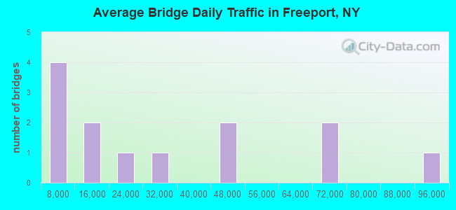
- 415,580Total average daily traffic
- 3,235Total average daily truck traffic
- National Bridge Inventory (NBI) Registered Bridges for Freeport
- No street view available for this location
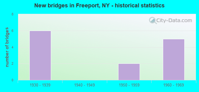
- New bridges - historical statistics
- 61930-1939
- 21950-1959
- 51960-1969

- Bridge Condition - Superstructure
- 33.3%Good
- 66.7%Satisfactory
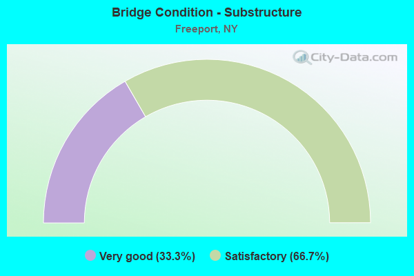
- Bridge Condition - Substructure
- 33.3%Very good
- 66.7%Satisfactory
Find on map >> Show street view
Structure Number: 1056611, Location: AT FREEPORT-S OF SSP (Lat: 40.684092, Lng: -73.573106), Route carried "on" structure: State highway 908E, Year Built: 1935, Status: Open, Structure Length: 0.98m (3.22ft), Average Daily Traffic: 42,046 (year 2018), Truck Traffic: 1%, Average Future Daily Traffic: 50,013 (year 2040), Design Load: HS 20, Features Intersected: EAST MEADOW BROOK
Minimum Vertical Clearance: 30+ m (98+ ft), Kilometerpoint: 10.362, Lanes on structure: 3, Base Highway Network: Yes, Owner: State Highway Agency, Approaching Roadway Width: 13.4m (44.0ft), Skew: 2 degrees, Material/Design: Concrete continuous, Design/Construction: Culvert, Number Of Spans In Main Unit: 3, Length of Maximum Span: 3.0m (9.8ft), Curb-To-Curb Width: 13.4m (44.0ft), Out-to-Out Width: 17.3m (56.8ft)
Condition: Channel: Satisfactory, Culverts: Satisfactory, Operating Rating: 50.8 metric tons, Method Used To Determine Operating Rating: Load Factor (LF), Inventory Rating: 29.9 metric tons, Method Used To Determine Inventory Rating: Load Factor (LF), Structural Evaluation: Equal to present minimum criteria, Deck Geometry: High priority of replacement, Waterway Adequacy: Equal to present minimum criteria, Approach Roadway Alignment: Equal to present desirable criteria, Length Of Structure Improvement: 0.97m (3.18ft), Designated Inspection Frequency: Every 24 months, Inspection Date: August 2021, Bridge Improvement Cost: $787,000, Roadway Improvement Cost: $461,000, Total Project Cost: $1,248,000 ( Estimate for 2021)
Find on map >> Show street view
Structure Number: 1059169, Location: AT FREEPORT-S OF SSP (Lat: 40.653817, Lng: -73.566939), Route carried "on" structure: County highway , Year Built: 1934, Status: Open, Structure Length: 2.65m (8.69ft), Average Daily Traffic: 40,382 (year 2019), Truck Traffic: 2%, Average Future Daily Traffic: 49,056 (year 2040), Features Intersected: 908E908E03011043, RTE 90, Facility Carried by Structure: MERRICK ROAD
Minimum Vertical Clearance: 30+ m (98+ ft), Kilometerpoint: 14.336, Lanes on structure: 5, Lanes under structure: 6, Owner: State Highway Agency, Approaching Roadway Width: 14.8m (48.6ft), Skew: 21 degrees, Material/Design: Concrete, Design/Construction: Arch - Deck, Number Of Spans In Main Unit: 1, Length of Maximum Span: 24.6m (80.7ft), Curb or Sidewalk Widths: Left: 3.0m (9.8ft), Right: 3.0m (9.8ft), Curb-To-Curb Width: 14.8m (48.6ft), Out-to-Out Width: 23.3m (76.4ft)
Condition: Superstructure: Good, Substructure: Very good, Operating Rating: 64.7 metric tons, Method Used To Determine Operating Rating: Field evaluation and documented engineering judgment, Inventory Rating: 24.5 metric tons, Method Used To Determine Inventory Rating: Field evaluation and documented engineering judgment, Structural Evaluation: Equal to present minimum criteria, Deck Geometry: High priority of replacement, Underclear: High priority of corrective action, Approach Roadway Alignment: Equal to present desirable criteria, Length Of Structure Improvement: 2.65m (8.69ft), Designated Inspection Frequency: Every 24 months, Inspection Date: Febuary 2021, Bridge Improvement Cost: $4,942,000, Roadway Improvement Cost: $2,894,000, Total Project Cost: $7,835,000 ( Estimate for 2021), Wearing Surface/Protective System: Wearing Surface: Bituminous
Find on map >> Show street view
Structure Number: 1059179, Location: AT FREEPORT-S OF SSP (Lat: 40.658481, Lng: -73.567922), Route carried "on" structure: State highway 908E, Year Built: 1938, Year Reconstructed: 1964, Status: Open, Structure Length: 3.29m (10.79ft), Average Daily Traffic: 71,723 (year 2019), Truck Traffic: 1%, Average Future Daily Traffic: 85,314 (year 2040), Design Load: H 20, Features Intersected: 27 27 03041086, E/B, RT
Minimum Vertical Clearance: 30+ m (98+ ft), Kilometerpoint: 7.450, Lanes on structure: 8, Lanes under structure: 6, Base Highway Network: Yes, Owner: State Highway Agency, Approaching Roadway Width: 34.7m (113.8ft), Skew: 22 degrees, Material/Design: Concrete continuous, Design/Construction: Frame, Number Of Spans In Main Unit: 2, Length of Maximum Span: 14.3m (46.9ft), Curb or Sidewalk Widths: Left: 0.6m (2.0ft), Right: 0.8m (2.6ft), Curb-To-Curb Width: 29.9m (98.1ft), Out-to-Out Width: 36.8m (120.7ft)
Condition: Deck: Satisfactory, Superstructure: Satisfactory, Substructure: Satisfactory, Operating Rating: 57.4 metric tons, Method Used To Determine Operating Rating: Field evaluation and documented engineering judgment, Inventory Rating: 23.6 metric tons, Method Used To Determine Inventory Rating: Field evaluation and documented engineering judgment, Structural Evaluation: Somewhat better than minimum adequacy, Deck Geometry: High priority of replacement, Underclear: High priority of corrective action, Approach Roadway Alignment: Equal to present desirable criteria, Length Of Structure Improvement: 3.29m (10.79ft), Designated Inspection Frequency: Every 24 months, Inspection Date: Febuary 2021, Bridge Improvement Cost: $6,451,000, Roadway Improvement Cost: $3,778,000, Total Project Cost: $10,228,000 ( Estimate for 2021), Wearing Surface/Protective System: Wearing Surface: Bituminous, Membrane: Preformed Fabric
Find on map >> Show street view
Structure Number: 1059189, Location: AT FREEPORT-S OF SSP (Lat: 40.660069, Lng: -73.568181), Route carried "on" structure: Other road 908E, Year Built: 1934, Status: Open, Structure Length: 1.95m (6.40ft), Average Daily Traffic: 71,723 (year 2019), Truck Traffic: 1%, Average Future Daily Traffic: 85,314 (year 2040), Design Load: H 20, Features Intersected: LONG ISLAND-MK BR
Minimum Vertical Clearance: 30+ m (98+ ft), Kilometerpoint: 7.627, Lanes on structure: 8, Base Highway Network: Yes, Owner: State Highway Agency, Approaching Roadway Width: 32.6m (107.0ft), Skew: 21 degrees, Material/Design: Concrete, Design/Construction: Frame, Number Of Spans In Main Unit: 1, Length of Maximum Span: 18.2m (59.7ft), Curb-To-Curb Width: 32.5m (106.6ft), Out-to-Out Width: 36.8m (120.7ft)
Condition: Deck: Satisfactory, Superstructure: Satisfactory, Substructure: Satisfactory, Operating Rating: 55.9 metric tons, Method Used To Determine Operating Rating: Field evaluation and documented engineering judgment, Inventory Rating: 20.3 metric tons, Method Used To Determine Inventory Rating: Field evaluation and documented engineering judgment, Structural Evaluation: Somewhat better than minimum adequacy, Deck Geometry: Meets minimum limits, Underclear: High priority of corrective action, Approach Roadway Alignment: Equal to present desirable criteria, Length Of Structure Improvement: 1.95m (6.40ft), Designated Inspection Frequency: Every 24 months, Inspection Date: August 2021, Bridge Improvement Cost: $6,367,000, Roadway Improvement Cost: $3,728,000, Total Project Cost: $10,095,000 ( Estimate for 2021)
Find on map >> Show street view
Structure Number: 33002, Location: 0.6 MI E BALDWIN (Lat: 40.651058, Lng: -73.603050), Route carried "on" structure: County highway , Year Built: 1956, Status: Open, Structure Length: 0.70m (2.30ft), Average Daily Traffic: 19,137 (year 2020), Truck Traffic: 3%, Average Future Daily Traffic: 23,247 (year 2040), Features Intersected: MILBURN CREEK, Facility Carried by Structure: MERRICK ROAD
Minimum Vertical Clearance: 30+ m (98+ ft), Kilometerpoint: 11.215, Lanes on structure: 4, Owner: County Highway Agency, Approaching Roadway Width: 17.7m (58.1ft), Skew: 21 degrees, Material/Design: Concrete, Design/Construction: Culvert, Number Of Spans In Main Unit: 2, Length of Maximum Span: 3.7m (12.1ft), Curb or Sidewalk Widths: Left: 2.1m (6.9ft), Right: 2.0m (6.6ft), Curb-To-Curb Width: 17.7m (58.1ft), Out-to-Out Width: 85.0m (278.9ft)
Condition: Channel: Satisfactory, Culverts: Satisfactory, Operating Rating: 59.9 metric tons, Method Used To Determine Operating Rating: Load Factor (LF), Inventory Rating: 35.4 metric tons, Method Used To Determine Inventory Rating: Load Factor (LF), Structural Evaluation: Equal to present minimum criteria, Deck Geometry: Somewhat better than minimum adequacy, Waterway Adequacy: Meets minimum limits, Approach Roadway Alignment: Equal to present desirable criteria, Length Of Structure Improvement: 0.70m (2.30ft), Designated Inspection Frequency: Every 24 months, Inspection Date: May 2020, Bridge Improvement Cost: $2,737,000, Roadway Improvement Cost: $1,603,000, Total Project Cost: $4,340,000 ( Estimate for 2021), Wearing Surface/Protective System: Wearing Surface: Bituminous
Find on map >> Show street view
Structure Number: 1059169, Location: AT FREEPORT-S OF SSP (Lat: 40.653817, Lng: -73.566939), Route carried "under" structure: State highway 908E, Year Built: 1934, Structure Length: 0. m, Average Daily Traffic: 31,171 (year 2002), Features Intersected: 908E908E03011043, RTE 90, Facility Carried by Structure: MERRICK ROAD
Minimum Vertical Clearance: 4.47m (14.67ft), Kilometerpoint: 6.806, Lanes on structure: 5, Lanes under structure: 3, Material/Design: Concrete, Design/Construction: Arch - Deck, Length of Maximum Span: 24.6m (80.7ft)
Find on map >> Show street view
Structure Number: 1059179, Location: AT FREEPORT-S OF SSP (Lat: 40.658481, Lng: -73.567922), Route carried "under" structure: State highway 27, Year Built: 1938, Structure Length: 0. m, Average Daily Traffic: 92,398 (year 2000), Features Intersected: 27 27 03041086, E/B, RT, Facility Carried by Structure: RTE 908E
Minimum Vertical Clearance: 4.75m (15.58ft), Kilometerpoint: 13.902, Lanes on structure: 8, Lanes under structure: 3, Material/Design: Concrete continuous, Design/Construction: Frame, Length of Maximum Span: 14.3m (46.9ft)
Find on map >> Show street view
Structure Number: 770987, Location: 0.5 MI E OF BALDWIN (Lat: 40.656689, Lng: -73.600883), Route carried "under" structure: Other road , Year Built: 1957, Structure Length: 0. m, Average Daily Traffic: 5,500 (year 1977), Features Intersected: BROOKSIDE AVE, Facility Carried by Structure: LIRR MONTAUK BR
Minimum Vertical Clearance: 4.44m (14.57ft), Kilometerpoint: 0.000, Lanes under structure: 4, Material/Design: Steel, Design/Construction: Girder and Floorbeam System, Length of Maximum Span: 23.1m (75.8ft)
Find on map >> Show street view
Structure Number: 770988, Location: 0.7 MI W OF FREEPORT (Lat: 40.656661, Lng: -73.594833), Route carried "under" structure: Other road , Year Built: 1960, Structure Length: 0. m, Average Daily Traffic: 7,000 (year 2021), Features Intersected: PENNSYLVANIA AV, Facility Carried by Structure: LIRR MONTAUK BR
Minimum Vertical Clearance: 4.36m (14.30ft), Kilometerpoint: 0.000, Lanes under structure: 2, Material/Design: Steel, Design/Construction: Girder and Floorbeam System, Length of Maximum Span: 24.3m (79.7ft)
Find on map >> Show street view
Structure Number: 770989, Location: 0.5 MI W OF FREEPORT (Lat: 40.656831, Lng: -73.590675), Route carried "under" structure: Other road , Year Built: 1960, Structure Length: 0. m, Average Daily Traffic: 7,000 (year 2021), Features Intersected: LONG BEACH AVE, Facility Carried by Structure: LIRR MONTAUK BR
Minimum Vertical Clearance: 4.47m (14.67ft), Kilometerpoint: 0.000, Lanes under structure: 2, Length of Maximum Span: 23.7m (77.8ft)
Find on map >> Show street view
Structure Number: 77099, Location: 0.4 MI W OF FREEPORT (Lat: 40.656942, Lng: -73.588217), Route carried "under" structure: Other road , Year Built: 1960, Structure Length: 0. m, Average Daily Traffic: 7,000 (year 2021), Features Intersected: BERGEN PLACE, Facility Carried by Structure: LIRR MONTAUK BR
Minimum Vertical Clearance: 4.39m (14.40ft), Kilometerpoint: 0.000, Lanes under structure: 2, Material/Design: Steel, Design/Construction: Girder and Floorbeam System, Length of Maximum Span: 23.1m (75.8ft)
Find on map >> Show street view
Structure Number: 770991, Location: 0.3 MI W OF FREEPORT (Lat: 40.657017, Lng: -73.586903), Route carried "under" structure: Other road , Year Built: 1960, Structure Length: 0. m, Average Daily Traffic: 9,000 (year 2021), Features Intersected: OCEAN AVE, Facility Carried by Structure: LIRR MONTAUK BR
Minimum Vertical Clearance: 4.39m (14.40ft), Kilometerpoint: 0.000, Lanes under structure: 4, Material/Design: Steel, Design/Construction: Girder and Floorbeam System, Length of Maximum Span: 26.5m (86.9ft)
Find on map >> Show street view
Structure Number: 770992, Location: AT FREEPORT (Lat: 40.657356, Lng: -73.583356), Route carried "under" structure: County highway , Year Built: 1960, Structure Length: 0. m, Average Daily Traffic: 11,500 (year 1977), Features Intersected: MAIN ST, Facility Carried by Structure: LIRR MONTAUK BR
Minimum Vertical Clearance: 4.41m (14.47ft), Kilometerpoint: 0.000, Lanes under structure: 12, Material/Design: Concrete continuous, Design/Construction: Slab, Length of Maximum Span: 30.4m (99.7ft)