Bridge Statistics for Fort Mitchell, Kentucky (KY)
Condition, Traffic, Stress, Structural Evaluation, Project Costs
- National Bridge Inventory (NBI) Statistics
- 11Number of bridges
- 79ft / 24.1mTotal length
- $4,322,000Total costs
- 344,302Total average daily traffic
- 51,498Total average daily truck traffic
- National Bridge Inventory (NBI) Registered Bridges for Fort Mitchell
- No street view available for this location
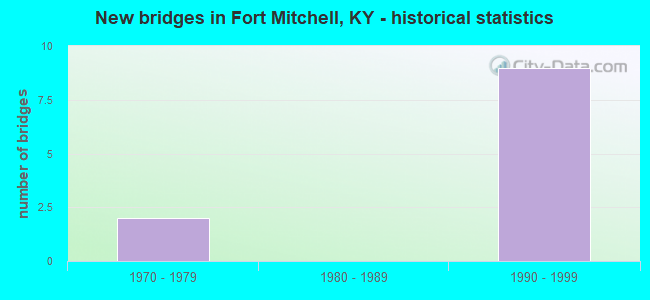
- New bridges - historical statistics
- 21970-1979
- 91990-1999
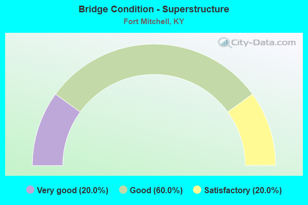
- Bridge Condition - Superstructure
- 20.0%Very good
- 60.0%Good
- 20.0%Satisfactory
Find on map >> Show street view
Structure Number: 59B00062R, Location: EBL .75 WEST OF KY 17 OP (Lat: 39.027500, Lng: -84.544444), Route carried "on" structure: Interstate 275, Year Built: 1974, Status: Open, Structure Length: 3.84m (12.60ft), Average Daily Traffic: 45,976 (year 2020), Truck Traffic: 8%, Average Future Daily Traffic: 49,194 (year 2040), Design Load: HS 20+Mod, Features Intersected: HORSEBRANCH ROAD
Minimum Vertical Clearance: 30+ m (98+ ft), Kilometerpoint: 129.852, Lanes on structure: 3, Lanes under structure: 2, Base Highway Network: Yes, Owner: State Highway Agency, Approaching Roadway Width: 25.0m (82.0ft), Skew: 12 degrees, Material/Design: Prestressed concrete continuous, Design/Construction: Stringer/Multi-beam, Number Of Spans In Main Unit: 3, Length of Maximum Span: 18.3m (60.0ft), Curb or Sidewalk Widths: Left: 0.6m (2.0ft), Right: 0.6m (2.0ft), Curb-To-Curb Width: 17.1m (56.1ft), Out-to-Out Width: 18.3m (60.0ft)
Condition: Deck: Good, Superstructure: Satisfactory, Substructure: Good, Operating Rating: 99.0 metric tons, Method Used To Determine Operating Rating: Load Factor (LF), Inventory Rating: 59.4 metric tons, Method Used To Determine Inventory Rating: Load Factor (LF), Structural Evaluation: Equal to present minimum criteria, Deck Geometry: Equal to present minimum criteria, Underclear: High priority of corrective action, Approach Roadway Alignment: Superior to present desirable criteria, Length Of Structure Improvement: 0.38m (1.25ft), Designated Inspection Frequency: Every 24 months, Inspection Date: October 2021, Bridge Improvement Cost: $945,000, Total Project Cost: $945,000, Deck Structure Type: Concrete Cast-file-Place, Wearing Surface/Protective System: Wearing Surface: Latex Concrete
Find on map >> Show street view
Structure Number: 59B00096L, Location: .25 MI N JCT KY 371 (Lat: 39.050833, Lng: -84.568056), Route carried "on" structure: Interstate 75, Year Built: 1993, Status: Open, Structure Length: 4.97m (16.31ft), Average Daily Traffic: 59,136 (year 2020), Truck Traffic: 19%, Average Future Daily Traffic: 63,276 (year 2040), Design Load: HS 25 or greater, Features Intersected: BEECHWOOD ROAD
Minimum Vertical Clearance: 30+ m (98+ ft), Kilometerpoint: 300.547, Lanes on structure: 5, Lanes under structure: 3, Base Highway Network: Yes, Owner: State Highway Agency, Approaching Roadway Width: 25.6m (84.0ft), Skew: 1 degrees, Material/Design: Prestressed concrete continuous, Design/Construction: Box Beam or Girders - Single/Spread, Number Of Spans In Main Unit: 3, Length of Maximum Span: 16.5m (54.1ft), Curb or Sidewalk Widths: Left: 0.5m (1.6ft), Right: 0.5m (1.6ft), Curb-To-Curb Width: 24.7m (81.0ft), Out-to-Out Width: 25.7m (84.3ft)
Condition: Deck: Good, Superstructure: Good, Substructure: Good, Operating Rating: 99.8 metric tons, Method Used To Determine Operating Rating: Load Factor (LF), Inventory Rating: 62.4 metric tons, Method Used To Determine Inventory Rating: Load Factor (LF), Structural Evaluation: Better than present minimum criteria, Deck Geometry: Better than present minimum criteria, Underclear: High priority of corrective action, Approach Roadway Alignment: Superior to present desirable criteria, Length Of Structure Improvement: 0.50m (1.64ft), Designated Inspection Frequency: Every 24 months, Inspection Date: November 2021, Bridge Improvement Cost: $1,716,000, Total Project Cost: $1,715,000, Deck Structure Type: Concrete Cast-file-Place, Wearing Surface/Protective System: Wearing Surface: Monolithic Concrete, Deck Protection: Epoxy Coated Reinforcing
Find on map >> Show street view
Structure Number: 59B00096R, Location: .25 MI N JCT KY 371 (Lat: 39.050556, Lng: -84.568056), Route carried "on" structure: Interstate 75, Year Built: 1993, Status: Open, Structure Length: 4.82m (15.81ft), Average Daily Traffic: 59,136 (year 2020), Truck Traffic: 19%, Average Future Daily Traffic: 63,276 (year 2040), Design Load: HS 25 or greater, Features Intersected: BEECHWOOD ROAD
Minimum Vertical Clearance: 30+ m (98+ ft), Kilometerpoint: 300.556, Lanes on structure: 3, Lanes under structure: 3, Base Highway Network: Yes, Owner: State Highway Agency, Approaching Roadway Width: 25.6m (84.0ft), Skew: 1 degrees, Material/Design: Prestressed concrete continuous, Design/Construction: Box Beam or Girders - Single/Spread, Number Of Spans In Main Unit: 3, Length of Maximum Span: 16.5m (54.1ft), Curb or Sidewalk Widths: Left: 0.5m (1.6ft), Right: 0.5m (1.6ft), Curb-To-Curb Width: 24.7m (81.0ft), Out-to-Out Width: 25.7m (84.3ft)
Condition: Deck: Good, Superstructure: Good, Substructure: Good, Operating Rating: 99.8 metric tons, Method Used To Determine Operating Rating: Load Factor (LF), Inventory Rating: 62.4 metric tons, Method Used To Determine Inventory Rating: Load Factor (LF), Structural Evaluation: Better than present minimum criteria, Deck Geometry: Superior to present desirable criteria, Underclear: High priority of corrective action, Approach Roadway Alignment: Superior to present desirable criteria, Length Of Structure Improvement: 0.48m (1.57ft), Designated Inspection Frequency: Every 24 months, Inspection Date: November 2021, Bridge Improvement Cost: $1,663,000, Total Project Cost: $1,662,000, Deck Structure Type: Concrete Cast-file-Place, Wearing Surface/Protective System: Wearing Surface: Monolithic Concrete, Deck Protection: Epoxy Coated Reinforcing
Find on map >> Show street view
Structure Number: 59B00099N, Location: 1.2 MI. NE JCT KY 371 (Lat: 39.051111, Lng: -84.551111), Route carried "on" structure: US 25, Year Built: 1999, Status: Open, Structure Length: 5.79m (19.00ft), Average Daily Traffic: 9,546 (year 2020), Truck Traffic: 5%, Average Future Daily Traffic: 8,877 (year 2040), Design Load: HS 25 or greater, Features Intersected: I-75 @ 187.72, Facility Carried by Structure: DIXIE HIGHWAY
Minimum Vertical Clearance: 30+ m (98+ ft), Kilometerpoint: 15.921, Lanes on structure: 4, Lanes under structure: 7, Owner: State Highway Agency, Approaching Roadway Width: 20.7m (67.9ft), Skew: 12 degrees, Material/Design: Prestressed concrete continuous, Design/Construction: Stringer/Multi-beam, Number Of Spans In Main Unit: 2, Length of Maximum Span: 33.2m (108.9ft), Curb or Sidewalk Widths: Left: 1.8m (5.9ft), Right: 1.8m (5.9ft), Curb-To-Curb Width: 21.9m (71.9ft), Out-to-Out Width: 26.5m (86.9ft)
Condition: Deck: Good, Superstructure: Good, Substructure: Good, Operating Rating: 86.2 metric tons, Method Used To Determine Operating Rating: Load Factor (LF), Inventory Rating: 51.7 metric tons, Method Used To Determine Inventory Rating: Load Factor (LF), Structural Evaluation: Better than present minimum criteria, Deck Geometry: Superior to present desirable criteria, Underclear: High priority of corrective action, Approach Roadway Alignment: Superior to present desirable criteria, Designated Inspection Frequency: Every 24 months, Inspection Date: November 2021, Deck Structure Type: Concrete Cast-file-Place, Wearing Surface/Protective System: Wearing Surface: Latex Concrete, Deck Protection: Epoxy Coated Reinforcing
Find on map >> Show street view
Structure Number: 59B00100R, Location: .25 MI. NE JCT US 25 OP (Lat: 39.053056, Lng: -84.547222), Route carried "on" structure: Interstate 75, Year Built: 1999, Status: Open, Structure Length: 4.63m (15.19ft), Average Daily Traffic: 51,819 (year 2020), Truck Traffic: 16%, Average Future Daily Traffic: 55,446 (year 2040), Design Load: HS 25 or greater, Features Intersected: ORCHARD ROAD
Minimum Vertical Clearance: 30+ m (98+ ft), Kilometerpoint: 302.491, Lanes on structure: 3, Lanes under structure: 2, Base Highway Network: Yes, Owner: State Highway Agency, Approaching Roadway Width: 22.6m (74.1ft), Skew: 1 degrees, Material/Design: Prestressed concrete continuous, Design/Construction: Stringer/Multi-beam, Number Of Spans In Main Unit: 3, Length of Maximum Span: 17.7m (58.1ft), Curb or Sidewalk Widths: Left: 0.5m (1.6ft), Right: 0.5m (1.6ft), Curb-To-Curb Width: 23.2m (76.1ft), Out-to-Out Width: 24.1m (79.1ft)
Condition: Deck: Good, Superstructure: Very good, Substructure: Good, Operating Rating: 99.8 metric tons, Method Used To Determine Operating Rating: Load Factor (LF), Inventory Rating: 65.0 metric tons, Method Used To Determine Inventory Rating: Load Factor (LF), Structural Evaluation: Better than present minimum criteria, Deck Geometry: Superior to present desirable criteria, Underclear: Better than present minimum criteria, Approach Roadway Alignment: Superior to present desirable criteria, Designated Inspection Frequency: Every 24 months, Inspection Date: November 2021, Deck Structure Type: Concrete Cast-file-Place, Wearing Surface/Protective System: Wearing Surface: Monolithic Concrete, Deck Protection: Epoxy Coated Reinforcing
Find on map >> Show street view
Structure Number: 59B00062R, Location: EBL .75 WEST OF KY 17 OP (Lat: 39.027500, Lng: -84.544444), Route carried "under" structure: City street 5550, Year Built: 1974, Structure Length: 0. m, Average Daily Traffic: 6,633 (year 2020), Features Intersected: HORSEBRANCH ROAD, Facility Carried by Structure: I-275 EB
Minimum Vertical Clearance: 30+ m (98+ ft), Kilometerpoint: 0.063, Lanes on structure: 3, Lanes under structure: 2, Material/Design: Prestressed concrete continuous, Design/Construction: Stringer/Multi-beam, Length of Maximum Span: 18.3m (60.0ft)
Find on map >> Show street view
Structure Number: 59B00096L, Location: .25 MI N JCT KY 371 (Lat: 39.050833, Lng: -84.568056), Route carried "under" structure: City street 7070, Year Built: 1993, Structure Length: 0. m, Average Daily Traffic: 3,889 (year 2020), Features Intersected: BEECHWOOD ROAD, Facility Carried by Structure: I-75 NC
Minimum Vertical Clearance: 30+ m (98+ ft), Kilometerpoint: 1.728, Lanes on structure: 5, Lanes under structure: 3, Material/Design: Prestressed concrete continuous, Design/Construction: Box Beam or Girders - Single/Spread, Length of Maximum Span: 16.5m (54.1ft)
Find on map >> Show street view
Structure Number: 59B00096R, Location: .25 MI N JCT KY 371 (Lat: 39.050556, Lng: -84.568056), Route carried "under" structure: City street 7070, Year Built: 1993, Structure Length: 0. m, Average Daily Traffic: 3,889 (year 2020), Features Intersected: BEECHWOOD ROAD, Facility Carried by Structure: I-75
Minimum Vertical Clearance: 30+ m (98+ ft), Kilometerpoint: 1.703, Lanes on structure: 3, Lanes under structure: 3, Material/Design: Prestressed concrete continuous, Design/Construction: Box Beam or Girders - Single/Spread, Length of Maximum Span: 16.5m (54.1ft)
Find on map >> Show street view
Structure Number: 59B00099N, Location: 1.2 MI. NE JCT KY 371 (Lat: 39.051111, Lng: -84.551111), Route carried "under" structure: Interstate 75, Year Built: 1999, Structure Length: 0. m, Average Daily Traffic: 103,638 (year 2020), Truck Traffic: 16%, Features Intersected: I-75 @ 187.72, Facility Carried by Structure: DIXIE HIGHWAY
Minimum Vertical Clearance: 6.40m (21.00ft), Kilometerpoint: 302.063, Lanes on structure: 4, Lanes under structure: 7, Material/Design: Prestressed concrete continuous, Design/Construction: Stringer/Multi-beam, Length of Maximum Span: 33.2m (108.9ft)
Find on map >> Show street view
Structure Number: 59B00100L, Location: .25 MI. NE JCT US 25 OP (Lat: 39.053333, Lng: -84.547222), Route carried "under" structure: State highway 2967, Year Built: 1999, Structure Length: 0. m, Average Daily Traffic: 320 (year 2020), Features Intersected: ORCHARD ROAD, Facility Carried by Structure: I-75 NC
Minimum Vertical Clearance: 30+ m (98+ ft), Kilometerpoint: 0.106, Lanes on structure: 4, Lanes under structure: 2, Material/Design: Prestressed concrete continuous, Design/Construction: Stringer/Multi-beam, Length of Maximum Span: 17.7m (58.1ft)
Find on map >> Show street view
Structure Number: 59B00100R, Location: .25 MI. NE JCT US 25 OP (Lat: 39.053056, Lng: -84.547222), Route carried "under" structure: State highway 2967, Year Built: 1999, Structure Length: 0. m, Average Daily Traffic: 320 (year 2020), Features Intersected: ORCHARD ROAD, Facility Carried by Structure: I-75
Minimum Vertical Clearance: 30+ m (98+ ft), Kilometerpoint: 0.085, Lanes on structure: 3, Lanes under structure: 2, Material/Design: Prestressed concrete continuous, Design/Construction: Stringer/Multi-beam, Length of Maximum Span: 17.7m (58.1ft)