Bridge Statistics for Florham Park, New Jersey (NJ)
Condition, Traffic, Stress, Structural Evaluation, Project Costs
- National Bridge Inventory (NBI) Statistics
- 29Number of bridges
- 217ft / 66.5mTotal length
- $6,008,000Total costs
- 1,027,379Total average daily traffic
- 47,173Total average daily truck traffic
- National Bridge Inventory (NBI) Registered Bridges for Florham Park
- No street view available for this location
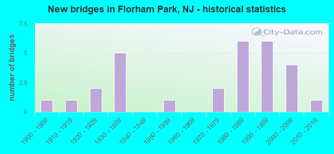
- New bridges - historical statistics
- 11900-1909
- 11910-1919
- 21920-1929
- 51930-1939
- 11950-1959
- 21970-1979
- 61980-1989
- 61990-1999
- 42000-2009
- 12010-2019

- Reconstructed bridges - Historical Statistics
- 11950-1959
- 11960-1969
- 11970-1979
- 01980-1989
- 21990-1999
- 12000-2009


- Bridge Condition - Deck
- 5.3%Very good
- 57.9%Good
- 21.1%Satisfactory
- 15.8%Fair

- Bridge Condition - Superstructure
- 19.0%Very good
- 23.8%Good
- 33.3%Satisfactory
- 23.8%Fair

- Bridge Condition - Substructure
- 42.9%Good
- 52.4%Satisfactory
- 4.8%Fair

- Bridge Condition - Channel
- 31.6%Good
- 57.9%Satisfactory
- 10.5%Fair

- Bridge Condition - Culverts
- 33.3%Good
- 66.7%Satisfactory
Find on map >> Show street view
Structure Number: 1400385, Location: 0.08M SW CR511 & NJ10 JCT (Lat: 40.823881, Lng: -74.419400), Route carried "on" structure: City street , Year Built: 1917, Status: Open, Structure Length: 0.64m (2.10ft), Average Daily Traffic: 2,327 (year 2019), Truck Traffic: 1%, Average Future Daily Traffic: 2,840 (year 2039), Design Load: H 20, Features Intersected: STONY BROOK, Facility Carried by Structure: MOUNT PLEASANT AVE
Minimum Vertical Clearance: 30+ m (98+ ft), Kilometerpoint: 0.467, Lanes on structure: 2, Owner: County Highway Agency, Approaching Roadway Width: 7.3m (24.0ft), Skew: 1 degrees, Material/Design: Masonry, Design/Construction: Arch - Deck, Number Of Spans In Main Unit: 1, Length of Maximum Span: 6.4m (21.0ft), Curb-To-Curb Width: 7.6m (24.9ft), Out-to-Out Width: 8.8m (28.9ft)
Condition: Superstructure: Satisfactory, Substructure: Good, Channel: Satisfactory, Operating Rating: 44.5 metric tons, Method Used To Determine Operating Rating: Field evaluation and documented engineering judgment, Inventory Rating: 26.3 metric tons, Method Used To Determine Inventory Rating: Field evaluation and documented engineering judgment, Structural Evaluation: Equal to present minimum criteria, Deck Geometry: High priority of replacement, Waterway Adequacy: Equal to present desirable criteria, Approach Roadway Alignment: Equal to present minimum criteria, Length Of Structure Improvement: 0.64m (2.10ft), Designated Inspection Frequency: Every 24 months, Inspection Date: July 2021, Bridge Improvement Cost: $32,000, Roadway Improvement Cost: $25,000, Total Project Cost: $107,000 ( Estimate for 2021)
Find on map >> Show street view
Structure Number: 1400386, Location: 0.02M S OF NJ10&CR622 JCT (Lat: 40.821481, Lng: -74.412419), Route carried "on" structure: County highway 622, Year Built: 2012, Status: Open, Structure Length: 2.23m (7.32ft), Average Daily Traffic: 14,421 (year 2021), Truck Traffic: 1%, Average Future Daily Traffic: 17,597 (year 2041), Design Load: HS 25 or greater, Features Intersected: WHIPPANY RIVER
Minimum Vertical Clearance: 30+ m (98+ ft), Kilometerpoint: 0.370, Lanes on structure: 4, Owner: County Highway Agency, Approaching Roadway Width: 12.2m (40.0ft), Skew: 2 degrees, Material/Design: Prestressed concrete, Design/Construction: Box Beam or Girders - Single/Spread, Number Of Spans In Main Unit: 1, Length of Maximum Span: 19.8m (65.0ft), Curb or Sidewalk Widths: Left: 1.2m (3.9ft), Right: 1.2m (3.9ft), Curb-To-Curb Width: 14.6m (47.9ft), Out-to-Out Width: 18.4m (60.4ft)
Condition: Deck: Good, Superstructure: Very good, Substructure: Good, Channel: Satisfactory, Inventory Rating: 63.5 metric tons, Method Used To Determine Inventory Rating: Load Factor (LF), Structural Evaluation: Better than present minimum criteria, Deck Geometry: High priority of replacement, Waterway Adequacy: Better than present minimum criteria, Approach Roadway Alignment: Equal to present minimum criteria, Length Of Structure Improvement: 2.13m (6.99ft), Designated Inspection Frequency: Every 24 months, Inspection Date: July 2021, Bridge Improvement Cost: $34,000, Roadway Improvement Cost: $24,000, Total Project Cost: $87,000 ( Estimate for 2021), Deck Structure Type: Concrete Cast-file-Place, Wearing Surface/Protective System: Wearing Surface: Monolithic Concrete, Deck Protection: Epoxy Coated Reinforcing
Find on map >> Show street view
Structure Number: 1400387, Location: 0.12MI W NJ10&CR622 JCT (Lat: 40.822711, Lng: -74.418019), Route carried "on" structure: County highway 511, Year Built: 1900, Year Reconstructed: 1999, Status: Open, Structure Length: 1.89m (6.20ft), Average Daily Traffic: 12,197 (year 2021), Truck Traffic: 4%, Average Future Daily Traffic: 14,882 (year 2041), Design Load: HS 25 or greater, Features Intersected: MALAPARDIS BROOK
Minimum Vertical Clearance: 30+ m (98+ ft), Kilometerpoint: 5.069, Lanes on structure: 2, Owner: County Highway Agency, Approaching Roadway Width: 11.6m (38.1ft), Material/Design: Prestressed concrete, Design/Construction: Box Beam or Girders - Multiple, Number Of Spans In Main Unit: 2, Length of Maximum Span: 8.5m (27.9ft), Curb or Sidewalk Widths: Left: 1.5m (4.9ft), Right: 1.5m (4.9ft), Curb-To-Curb Width: 11.3m (37.1ft), Out-to-Out Width: 15.0m (49.2ft)
Condition: Deck: Satisfactory, Superstructure: Good, Substructure: Good, Channel: Satisfactory, Inventory Rating: 82.6 metric tons, Method Used To Determine Inventory Rating: Load Factor (LF), Structural Evaluation: Better than present minimum criteria, Deck Geometry: Meets minimum limits, Waterway Adequacy: Equal to present minimum criteria, Approach Roadway Alignment: Equal to present minimum criteria, Designated Inspection Frequency: Every 24 months, Inspection Date: August 2021, Deck Structure Type: Concrete Cast-file-Place, Wearing Surface/Protective System: Wearing Surface: Monolithic Concrete, Deck Protection: Epoxy Coated Reinforcing
Find on map >> Show street view
Structure Number: 1400388, Location: 1.2MI NW of I287&NJ10 JCT (Lat: 40.822331, Lng: -74.418200), Route carried "on" structure: County highway 511, Year Built: 1950, Status: Open, Structure Length: 1.19m (3.90ft), Average Daily Traffic: 13,275 (year 2021), Truck Traffic: 4%, Average Future Daily Traffic: 16,198 (year 2041), Features Intersected: WHIPPANY RIVER
Minimum Vertical Clearance: 30+ m (98+ ft), Kilometerpoint: 5.037, Lanes on structure: 2, Owner: County Highway Agency, Approaching Roadway Width: 9.8m (32.2ft), Material/Design: Steel, Design/Construction: Stringer/Multi-beam, Number Of Spans In Main Unit: 1, Length of Maximum Span: 11.3m (37.1ft), Curb or Sidewalk Widths: Left: 1.5m (4.9ft), Right: 1.5m (4.9ft), Curb-To-Curb Width: 9.1m (29.9ft), Out-to-Out Width: 13.0m (42.7ft)
Condition: Deck: Fair, Superstructure: Satisfactory, Substructure: Satisfactory, Channel: Satisfactory, Operating Rating: 36.3 metric tons, Method Used To Determine Operating Rating: Load Factor (LF), Inventory Rating: 21.8 metric tons, Method Used To Determine Inventory Rating: Load Factor (LF), Structural Evaluation: Somewhat better than minimum adequacy, Deck Geometry: High priority of corrective action, Waterway Adequacy: Superior to present desirable criteria, Approach Roadway Alignment: Equal to present minimum criteria, Length Of Structure Improvement: 1.19m (3.90ft), Designated Inspection Frequency: Every 24 months, Inspection Date: July 2021, Bridge Improvement Cost: $95,000, Roadway Improvement Cost: $24,000, Total Project Cost: $263,000 ( Estimate for 2021), Deck Structure Type: Concrete Cast-file-Place, Wearing Surface/Protective System: Wearing Surface: Bituminous
Find on map >> Show street view
Structure Number: 1400392, Location: 0.9MI NE OF I287&NJ24 JCT (Lat: 40.820139, Lng: -74.435169), Route carried "on" structure: City street , Year Built: 2008, Status: Open, Structure Length: 3.69m (12.11ft), Average Daily Traffic: 4,494 (year 2021), Truck Traffic: 3%, Average Future Daily Traffic: 5,483 (year 2041), Design Load: HL 93, Features Intersected: WHIPPANY RIVER, Facility Carried by Structure: EDEN LANE
Minimum Vertical Clearance: 30+ m (98+ ft), Kilometerpoint: 1.287, Lanes on structure: 2, Owner: County Highway Agency, Approaching Roadway Width: 11.0m (36.1ft), Skew: 1 degrees, Material/Design: Steel, Design/Construction: Stringer/Multi-beam, Number Of Spans In Main Unit: 1, Length of Maximum Span: 35.4m (116.1ft), Curb or Sidewalk Widths: Left: 0.0m, Right: 1.8m (5.9ft), Curb-To-Curb Width: 11.0m (36.1ft), Out-to-Out Width: 14.0m (45.9ft)
Condition: Deck: Good, Superstructure: Very good, Substructure: Good, Channel: Good, Operating Rating: 67.1 metric tons, Method Used To Determine Operating Rating: Load and Resistance Factor Rating (LRFR) rating reported by rating factor(RF) method using HL-93 loadings, Inventory Rating: 51.5 metric tons, Method Used To Determine Inventory Rating: Load and Resistance Factor Rating (LRFR) rating reported by rating factor(RF) method using HL-93 loadings, Structural Evaluation: Better than present minimum criteria, Deck Geometry: Somewhat better than minimum adequacy, Waterway Adequacy: Superior to present desirable criteria, Approach Roadway Alignment: Equal to present desirable criteria, Designated Inspection Frequency: Every 24 months, Inspection Date: July 2021, Deck Structure Type: Concrete Cast-file-Place, Wearing Surface/Protective System: Wearing Surface: Monolithic Concrete, Deck Protection: Epoxy Coated Reinforcing
Find on map >> Show street view
Structure Number: 1400424, Location: 2.54MI SW OF I287&I80 JCT (Lat: 40.824931, Lng: -74.383931), Route carried "on" structure: City street , Year Built: 2006, Status: Open, Structure Length: 0.61m (2.00ft), Average Daily Traffic: 9,254 (year 2019), Truck Traffic: 4%, Average Future Daily Traffic: 11,292 (year 2039), Design Load: HS 20+Mod, Features Intersected: SMITH DITCH, Facility Carried by Structure: TROY ROAD
Minimum Vertical Clearance: 30+ m (98+ ft), Kilometerpoint: 1.658, Lanes on structure: 2, Owner: County Highway Agency, Approaching Roadway Width: 10.7m (35.1ft), Material/Design: Concrete, Design/Construction: Culvert, Number Of Spans In Main Unit: 1, Length of Maximum Span: 6.1m (20.0ft), Curb-To-Curb Width: 11.0m (36.1ft), Out-to-Out Width: 12.0m (39.4ft)
Condition: Channel: Satisfactory, Culverts: Good, Operating Rating: 68.0 metric tons, Method Used To Determine Operating Rating: Load Factor (LF), Inventory Rating: 40.8 metric tons, Method Used To Determine Inventory Rating: Load Factor (LF), Structural Evaluation: Better than present minimum criteria, Deck Geometry: Meets minimum limits, Waterway Adequacy: Better than present minimum criteria, Approach Roadway Alignment: Better than present minimum criteria, Designated Inspection Frequency: Every 24 months, Underwater Inspection Frequency: Every 24 months, Inspection Date: July 2021, Underwater Inspection Date: August 2021, Deck Structure Type: Concrete Precast Panels, Wearing Surface/Protective System: Wearing Surface: Bituminous
Find on map >> Show street view
Structure Number: 1400425, Location: 1.9MI E OF CR637&NJ10 JCT (Lat: 40.824381, Lng: -74.370631), Route carried "on" structure: City street , Year Built: 2007, Status: Open, Structure Length: 2.26m (7.41ft), Average Daily Traffic: 9,440 (year 2021), Truck Traffic: 4%, Average Future Daily Traffic: 11,518 (year 2041), Design Load: HS 25 or greater, Features Intersected: WHIPPANY RIVER, Facility Carried by Structure: TROY ROAD
Minimum Vertical Clearance: 30+ m (98+ ft), Kilometerpoint: 0.547, Lanes on structure: 2, Owner: County Highway Agency, Approaching Roadway Width: 11.0m (36.1ft), Skew: 1 degrees, Material/Design: Prestressed concrete, Design/Construction: Box Beam or Girders - Multiple, Number Of Spans In Main Unit: 1, Length of Maximum Span: 21.0m (68.9ft), Curb-To-Curb Width: 11.0m (36.1ft), Out-to-Out Width: 12.0m (39.4ft)
Condition: Deck: Good, Superstructure: Very good, Substructure: Good, Channel: Satisfactory, Inventory Rating: 59.0 metric tons, Method Used To Determine Inventory Rating: Load Factor (LF), Structural Evaluation: Better than present minimum criteria, Deck Geometry: Meets minimum limits, Waterway Adequacy: Better than present minimum criteria, Approach Roadway Alignment: Better than present minimum criteria, Designated Inspection Frequency: Every 24 months, Inspection Date: July 2021, Deck Structure Type: Concrete Cast-file-Place, Wearing Surface/Protective System: Deck Protection: Epoxy Coated Reinforcing
Find on map >> Show street view
Structure Number: 140044, Location: 0.35MI E I280&CR632 JCT (Lat: 40.844850, Lng: -74.349500), Route carried "on" structure: County highway 632, Year Built: 1970, Year Reconstructed: 1996, Status: Open, Structure Length: 6.16m (20.21ft), Average Daily Traffic: 15,926 (year 2021), Truck Traffic: 4%, Average Future Daily Traffic: 19,433 (year 2041), Design Load: HS 20, Features Intersected: WHIPPANY RIVER
Minimum Vertical Clearance: 30+ m (98+ ft), Kilometerpoint: 9.463, Lanes on structure: 4, Owner: County Highway Agency, Approaching Roadway Width: 14.0m (45.9ft), Skew: 3 degrees, Material/Design: Steel, Design/Construction: Stringer/Multi-beam, Number Of Spans In Main Unit: 2, Length of Maximum Span: 29.6m (97.1ft), Curb or Sidewalk Widths: Left: 1.9m (6.2ft), Right: 1.9m (6.2ft), Curb-To-Curb Width: 14.0m (45.9ft), Out-to-Out Width: 18.4m (60.4ft)
Condition: Deck: Fair, Superstructure: Satisfactory, Substructure: Satisfactory, Channel: Satisfactory, Operating Rating: 88.0 metric tons, Method Used To Determine Operating Rating: Load Factor (LF), Inventory Rating: 52.6 metric tons, Method Used To Determine Inventory Rating: Load Factor (LF), Structural Evaluation: Equal to present minimum criteria, Deck Geometry: High priority of replacement, Waterway Adequacy: Better than present minimum criteria, Approach Roadway Alignment: Better than present minimum criteria, Length Of Structure Improvement: 6.16m (20.21ft), Designated Inspection Frequency: Every 24 months, Inspection Date: June 2021, Bridge Improvement Cost: $146,000, Roadway Improvement Cost: $58,000, Total Project Cost: $259,000 ( Estimate for 2021), Deck Structure Type: Concrete Cast-file-Place, Wearing Surface/Protective System: Wearing Surface: Monolithic Concrete, Deck Protection: Epoxy Coated Reinforcing
Find on map >> Show street view
Structure Number: 1400447, Location: 0.7MI W CR510&CR609 JCT (Lat: 40.779181, Lng: -74.369161), Route carried "on" structure: County highway 510, Year Built: 1980, Status: Open, Structure Length: 3.96m (12.99ft), Average Daily Traffic: 22,053 (year 2021), Truck Traffic: 4%, Average Future Daily Traffic: 26,909 (year 2041), Design Load: HS 20+Mod, Features Intersected: PASSAIC RIVER
Minimum Vertical Clearance: 30+ m (98+ ft), Kilometerpoint: 28.759, Lanes on structure: 4, Base Highway Network: Yes, Owner: County Highway Agency, Approaching Roadway Width: 16.5m (54.1ft), Skew: 30 degrees, Material/Design: Steel, Design/Construction: Stringer/Multi-beam, Number Of Spans In Main Unit: 1, Length of Maximum Span: 37.8m (124.0ft), Curb or Sidewalk Widths: Left: 2.4m (7.9ft), Right: 0.2m (0.7ft), Curb-To-Curb Width: 16.5m (54.1ft), Out-to-Out Width: 20.4m (66.9ft)
Condition: Deck: Satisfactory, Superstructure: Good, Substructure: Satisfactory, Channel: Satisfactory, Inventory Rating: 61.7 metric tons, Method Used To Determine Inventory Rating: Load Factor (LF), Structural Evaluation: Equal to present minimum criteria, Deck Geometry: Meets minimum limits, Waterway Adequacy: Equal to present desirable criteria, Approach Roadway Alignment: Equal to present desirable criteria, Designated Inspection Frequency: Every 24 months, Inspection Date: July 2021, Deck Structure Type: Concrete Cast-file-Place, Wearing Surface/Protective System: Wearing Surface: Monolithic Concrete, Deck Protection: Epoxy Coated Reinforcing
Find on map >> Show street view
Structure Number: 1400451, Location: 0.8MI E NJ24&CR510 (Lat: 40.790581, Lng: -74.412950), Route carried "on" structure: County highway 510, Year Built: 1929, Year Reconstructed: 1960, Status: Open, Structure Length: 1.07m (3.51ft), Average Daily Traffic: 30,125 (year 2021), Truck Traffic: 4%, Average Future Daily Traffic: 36,758 (year 2041), Features Intersected: BLACK BROOK
Minimum Vertical Clearance: 30+ m (98+ ft), Kilometerpoint: 24.752, Lanes on structure: 4, Base Highway Network: Yes, Owner: County Highway Agency, Approaching Roadway Width: 14.0m (45.9ft), Material/Design: Steel, Design/Construction: Stringer/Multi-beam, Number Of Spans In Main Unit: 1, Length of Maximum Span: 9.4m (30.8ft), Curb or Sidewalk Widths: Left: 1.5m (4.9ft), Right: 1.5m (4.9ft), Curb-To-Curb Width: 13.9m (45.6ft), Out-to-Out Width: 17.5m (57.4ft)
Condition: Deck: Satisfactory, Superstructure: Fair, Substructure: Satisfactory, Channel: Good, Operating Rating: 60.8 metric tons, Method Used To Determine Operating Rating: Load Factor (LF), Inventory Rating: 36.3 metric tons, Method Used To Determine Inventory Rating: Load Factor (LF), Structural Evaluation: Somewhat better than minimum adequacy, Deck Geometry: High priority of replacement, Waterway Adequacy: Equal to present desirable criteria, Approach Roadway Alignment: Equal to present desirable criteria, Length Of Structure Improvement: 1.07m (3.51ft), Designated Inspection Frequency: Every 24 months, Inspection Date: July 2021, Bridge Improvement Cost: $37,000, Roadway Improvement Cost: $28,000, Total Project Cost: $96,000 ( Estimate for 2021), Deck Structure Type: Concrete Cast-file-Place, Wearing Surface/Protective System: Wearing Surface: Bituminous
Find on map >> Show street view
Structure Number: 1400458, Location: 1.5MI NE NJ124&CR608 JCT (Lat: 40.764319, Lng: -74.387339), Route carried "on" structure: City street , Year Built: 1936, Year Reconstructed: 1962, Status: Open, Structure Length: 0.79m (2.59ft), Average Daily Traffic: 2,706 (year 2021), Truck Traffic: 3%, Average Future Daily Traffic: 3,302 (year 2041), Features Intersected: SPRING GARDEN BROOK, Facility Carried by Structure: EAST MADISON AVE
Minimum Vertical Clearance: 30+ m (98+ ft), Kilometerpoint: 2.366, Lanes on structure: 2, Owner: County Highway Agency, Approaching Roadway Width: 9.8m (32.2ft), Material/Design: Steel, Design/Construction: Stringer/Multi-beam, Number Of Spans In Main Unit: 1, Length of Maximum Span: 6.4m (21.0ft), Curb-To-Curb Width: 9.8m (32.2ft), Out-to-Out Width: 9.9m (32.5ft)
Condition: Deck: Fair, Superstructure: Fair, Substructure: Fair, Channel: Fair, Operating Rating: 28.1 metric tons, Method Used To Determine Operating Rating: Load Factor (LF), Inventory Rating: 16.3 metric tons, Method Used To Determine Inventory Rating: Load Factor (LF), Structural Evaluation: Meets minimum limits, Deck Geometry: Meets minimum limits, Waterway Adequacy: Better than present minimum criteria, Approach Roadway Alignment: Equal to present minimum criteria, Length Of Structure Improvement: 0.79m (2.59ft), Designated Inspection Frequency: Every 24 months, Inspection Date: August 2021, Bridge Improvement Cost: $38,000, Total Project Cost: $147,000 ( Estimate for 2021), Deck Structure Type: Concrete Cast-file-Place, Wearing Surface/Protective System: Wearing Surface: Bituminous
Find on map >> Show street view
Structure Number: 1400467, Location: 1.7MI NW NJ24&NJ124 JCT (Lat: 40.763231, Lng: -74.378519), Route carried "on" structure: City street , Year Built: 1928, Year Reconstructed: 1977, Status: Open, Structure Length: 0.79m (2.59ft), Average Daily Traffic: 6,090 (year 2021), Truck Traffic: 1%, Average Future Daily Traffic: 7,430 (year 2041), Features Intersected: SPRING GARDEN BROOK, Facility Carried by Structure: BROOKLAKE ROAD
Minimum Vertical Clearance: 30+ m (98+ ft), Kilometerpoint: 0.000, Lanes on structure: 2, Owner: County Highway Agency, Approaching Roadway Width: 7.9m (25.9ft), Skew: 3 degrees, Material/Design: Steel, Design/Construction: Stringer/Multi-beam, Number Of Spans In Main Unit: 1, Length of Maximum Span: 6.7m (22.0ft), Curb or Sidewalk Widths: Left: 0.2m (0.7ft), Right: 0.2m (0.7ft), Curb-To-Curb Width: 7.7m (25.3ft), Out-to-Out Width: 8.9m (29.2ft)
Condition: Deck: Good, Superstructure: Fair, Substructure: Satisfactory, Channel: Fair, Operating Rating: 41.7 metric tons, Method Used To Determine Operating Rating: Load Factor (LF), Inventory Rating: 24.5 metric tons, Method Used To Determine Inventory Rating: Load Factor (LF), Structural Evaluation: Somewhat better than minimum adequacy, Deck Geometry: High priority of replacement, Waterway Adequacy: Superior to present desirable criteria, Approach Roadway Alignment: Equal to present minimum criteria, Length Of Structure Improvement: 0.79m (2.59ft), Designated Inspection Frequency: Every 24 months, Inspection Date: August 2021, Bridge Improvement Cost: $258,000, Roadway Improvement Cost: $24,000, Total Project Cost: $325,000 ( Estimate for 2021), Deck Structure Type: Concrete Cast-file-Place, Wearing Surface/Protective System: Wearing Surface: Bituminous
Find on map >> Show street view
Structure Number: 140215, Location: .89 MILE EAST OF I-287 (Lat: 40.826339, Lng: -74.423550), Route carried "on" structure: State highway 10, Year Built: 1932, Status: Open, Structure Length: 0.85m (2.79ft), Average Daily Traffic: 34,045 (year 2020), Truck Traffic: 4%, Average Future Daily Traffic: 40,645 (year 2020), Features Intersected: MALAPARDIS BROOK
Minimum Vertical Clearance: 30+ m (98+ ft), Kilometerpoint: 22.354, Lanes on structure: 4, Base Highway Network: Yes, Owner: State Highway Agency, Approaching Roadway Width: 20.3m (66.6ft), Skew: 32 degrees, Material/Design: Concrete, Design/Construction: Slab, Number Of Spans In Main Unit: 1, Length of Maximum Span: 7.3m (24.0ft), Curb or Sidewalk Widths: Left: 0.6m (2.0ft), Right: 1.0m (3.3ft), Curb-To-Curb Width: 20.3m (66.6ft), Out-to-Out Width: 23.4m (76.8ft)
Condition: Superstructure: Fair, Substructure: Good, Channel: Satisfactory, Operating Rating: 44.5 metric tons, Method Used To Determine Operating Rating: Load Factor (LF), Inventory Rating: 26.3 metric tons, Method Used To Determine Inventory Rating: Load Factor (LF), Structural Evaluation: Somewhat better than minimum adequacy, Deck Geometry: Equal to present desirable criteria, Waterway Adequacy: Equal to present minimum criteria, Approach Roadway Alignment: Equal to present desirable criteria, Length Of Structure Improvement: 0.85m (2.79ft), Designated Inspection Frequency: Every 24 months, Inspection Date: April 2020, Bridge Improvement Cost: $143,000, Total Project Cost: $255,000 ( Estimate for 2020)
Find on map >> Show street view
Structure Number: 1402151, Location: 1.87 MILE EAST OF I-287 (Lat: 40.824431, Lng: -74.418089), Route carried "on" structure: County highway 511, Year Built: 1931, Status: Open, Structure Length: 2.53m (8.30ft), Average Daily Traffic: 7,456 (year 2020), Truck Traffic: 4%, Average Future Daily Traffic: 8,947 (year 2040), Features Intersected: NJ 10
Minimum Vertical Clearance: 30+ m (98+ ft), Kilometerpoint: 5.263, Lanes on structure: 2, Lanes under structure: 4, Owner: State Highway Agency, Approaching Roadway Width: 9.1m (29.9ft), Skew: 3 degrees, Material/Design: Steel, Design/Construction: Stringer/Multi-beam, Number Of Spans In Main Unit: 1, Length of Maximum Span: 23.8m (78.1ft), Curb or Sidewalk Widths: Left: 1.9m (6.2ft), Right: 1.9m (6.2ft), Curb-To-Curb Width: 9.1m (29.9ft), Out-to-Out Width: 13.5m (44.3ft)
Condition: Deck: Satisfactory, Superstructure: Fair, Substructure: Satisfactory, Operating Rating: 70.8 metric tons, Method Used To Determine Operating Rating: Load Factor (LF), Inventory Rating: 41.7 metric tons, Method Used To Determine Inventory Rating: Load Factor (LF), Structural Evaluation: Somewhat better than minimum adequacy, Deck Geometry: High priority of corrective action, Underclear: High priority of replacement, Approach Roadway Alignment: Equal to present minimum criteria, Length Of Structure Improvement: 3.29m (10.79ft), Designated Inspection Frequency: Every 24 months, Inspection Date: April 2020, Bridge Improvement Cost: $2,899,000, Roadway Improvement Cost: $290,000, Total Project Cost: $4,469,000 ( Estimate for 2020), Deck Structure Type: Concrete Cast-file-Place, Wearing Surface/Protective System: Wearing Surface: Bituminous
Find on map >> Show street view
Structure Number: 1402152, Location: 2.75MILES EAST OF I-287 (Lat: 40.812781, Lng: -74.393611), Route carried "on" structure: State highway 10, Year Built: 2003, Status: Open, Structure Length: 3.17m (10.40ft), Average Daily Traffic: 34,047 (year 2020), Truck Traffic: 4%, Average Future Daily Traffic: 44,261 (year 2040), Design Load: HS 20+Mod, Features Intersected: WHIPPANY RIVER
Minimum Vertical Clearance: 30.45m (99.90ft), Kilometerpoint: 25.347, Lanes on structure: 6, Base Highway Network: Yes, Owner: State Highway Agency, Approaching Roadway Width: 23.4m (76.8ft), Skew: 31 degrees, Material/Design: Steel, Design/Construction: Stringer/Multi-beam, Number Of Spans In Main Unit: 1, Length of Maximum Span: 29.9m (98.1ft), Curb or Sidewalk Widths: Left: 1.8m (5.9ft), Right: 0.0m, Curb-To-Curb Width: 25.2m (82.7ft), Out-to-Out Width: 28.2m (92.5ft)
Condition: Deck: Good, Superstructure: Good, Substructure: Good, Channel: Satisfactory, Inventory Rating: 73.5 metric tons, Method Used To Determine Inventory Rating: Load Factor (LF), Structural Evaluation: Better than present minimum criteria, Deck Geometry: Somewhat better than minimum adequacy, Waterway Adequacy: Equal to present desirable criteria, Approach Roadway Alignment: Equal to present desirable criteria, Designated Inspection Frequency: Every 24 months, Inspection Date: April 2020, Deck Structure Type: Concrete Cast-file-Place, Wearing Surface/Protective System: Wearing Surface: Latex Concrete, Deck Protection: Epoxy Coated Reinforcing
Find on map >> Show street view
Structure Number: 1402153, Location: 4.75 Miles E of I-287 JCT (Lat: 40.800661, Lng: -74.359169), Route carried "on" structure: State highway 10, Year Built: 1931, Year Reconstructed: 2014, Status: Open, Structure Length: 3.26m (10.70ft), Average Daily Traffic: 31,705 (year 2020), Truck Traffic: 4%, Average Future Daily Traffic: 38,687 (year 2040), Design Load: HL 93, Features Intersected: Passaic River
Minimum Vertical Clearance: 30+ m (98+ ft), Kilometerpoint: 28.566, Lanes on structure: 4, Base Highway Network: Yes, Owner: State Highway Agency, Approaching Roadway Width: 15.2m (49.9ft), Skew: 30 degrees, Material/Design: Prestressed concrete, Design/Construction: Tee Beam, Number Of Spans In Main Unit: 3, Length of Maximum Span: 10.4m (34.1ft), Curb or Sidewalk Widths: Left: 1.8m (5.9ft), Right: 1.8m (5.9ft), Curb-To-Curb Width: 15.2m (49.9ft), Out-to-Out Width: 20.1m (65.9ft)
Condition: Deck: Very good, Superstructure: Very good, Substructure: Satisfactory, Channel: Satisfactory, Operating Rating: 96.9 metric tons, Method Used To Determine Operating Rating: Load and Resistance Factor Rating (LRFR) rating reported by rating factor(RF) method using HL-93 loadings, Inventory Rating: 82.6 metric tons, Method Used To Determine Inventory Rating: Load and Resistance Factor Rating (LRFR) rating reported by rating factor(RF) method using HL-93 loadings, Structural Evaluation: Equal to present minimum criteria, Deck Geometry: High priority of corrective action, Waterway Adequacy: Equal to present desirable criteria, Approach Roadway Alignment: Equal to present desirable criteria, Designated Inspection Frequency: Every 24 months, Underwater Inspection Frequency: Every 48 months, Inspection Date: June 2020, Underwater Inspection Date: June 2018, Deck Structure Type: Concrete Precast Panels, Wearing Surface/Protective System: Wearing Surface: Integral Concrete, Deck Protection: Epoxy Coated Reinforcing
Find on map >> Show street view
Structure Number: 1410002, Location: 1.1M SE of CR632&NJ10 JCT (Lat: 40.802139, Lng: -74.377961), Route carried "on" structure: City street , Year Built: 1976, Status: Open, Structure Length: 0.79m (2.59ft), Average Daily Traffic: 700 (year 2019), Truck Traffic: 1%, Average Future Daily Traffic: 855 (year 2039), Design Load: HS 20, Features Intersected: PINCH BROOK, Facility Carried by Structure: TIMBER HILL DRIVE
Minimum Vertical Clearance: 30+ m (98+ ft), Kilometerpoint: 0.000, Lanes on structure: 2, Owner: City or Municipal Highway Agency, Approaching Roadway Width: 9.1m (29.9ft), Material/Design: Prestressed concrete, Design/Construction: Culvert, Number Of Spans In Main Unit: 1, Length of Maximum Span: 7.0m (23.0ft), Curb or Sidewalk Widths: Left: 2.7m (8.9ft), Right: 2.7m (8.9ft), Curb-To-Curb Width: 9.2m (30.2ft), Out-to-Out Width: 15.3m (50.2ft)
Condition: Channel: Good, Culverts: Satisfactory, Operating Rating: 82.6 metric tons, Method Used To Determine Operating Rating: Load Factor (LF), Inventory Rating: 49.9 metric tons, Method Used To Determine Inventory Rating: Load Factor (LF), Structural Evaluation: Equal to present minimum criteria, Deck Geometry: Equal to present minimum criteria, Waterway Adequacy: Better than present minimum criteria, Approach Roadway Alignment: Equal to present desirable criteria, Designated Inspection Frequency: Every 24 months, Inspection Date: July 2021, Deck Structure Type: Concrete Cast-file-Place, Wearing Surface/Protective System: Wearing Surface: Monolithic Concrete
Find on map >> Show street view
Structure Number: 1422152, Location: 0.37 mi E of CR 510 (Lat: 40.788761, Lng: -74.423731), Route carried "on" structure: State highway 24, Year Built: 1993, Status: Open, Structure Length: 0.64m (2.10ft), Average Daily Traffic: 95,916 (year 2021), Truck Traffic: 5%, Average Future Daily Traffic: 115,099 (year 2041), Design Load: HS 20+Mod, Features Intersected: BLACK BROOK TRIBUTARY
Minimum Vertical Clearance: 30+ m (98+ ft), Kilometerpoint: 3.879, Lanes on structure: 7, Base Highway Network: Yes, Owner: State Highway Agency, Approaching Roadway Width: 39.3m (128.9ft), Skew: 30 degrees, Material/Design: Concrete, Design/Construction: Culvert, Number Of Spans In Main Unit: 2, Length of Maximum Span: 3.0m (9.8ft)
Condition: Channel: Good, Culverts: Satisfactory, Operating Rating: 78.9 metric tons, Method Used To Determine Operating Rating: Load Factor (LF), Inventory Rating: 47.2 metric tons, Method Used To Determine Inventory Rating: Load Factor (LF), Structural Evaluation: Equal to present minimum criteria, Waterway Adequacy: Equal to present desirable criteria, Approach Roadway Alignment: Equal to present desirable criteria, Designated Inspection Frequency: Every 24 months, Inspection Date: June 2021
Find on map >> Show street view
Structure Number: 1422153, Location: 0.82 mi E of CR 510 (Lat: 40.783689, Lng: -74.417369), Route carried "on" structure: State highway 24, Year Built: 1989, Status: Open, Structure Length: 1.74m (5.71ft), Average Daily Traffic: 103,882 (year 2021), Truck Traffic: 5%, Average Future Daily Traffic: 124,659 (year 2041), Design Load: HS 20+Mod, Features Intersected: W. Branch Black Brook
Minimum Vertical Clearance: 30+ m (98+ ft), Kilometerpoint: 4.683, Lanes on structure: 4, Base Highway Network: Yes, Owner: State Highway Agency, Approaching Roadway Width: 35.7m (117.1ft), Skew: 31 degrees, Material/Design: Prestressed concrete, Design/Construction: Box Beam or Girders - Multiple, Number Of Spans In Main Unit: 1, Length of Maximum Span: 15.8m (51.8ft), Curb-To-Curb Width: 35.8m (117.5ft), Out-to-Out Width: 37.9m (124.3ft)
Condition: Deck: Good, Superstructure: Satisfactory, Substructure: Good, Channel: Good, Inventory Rating: 61.7 metric tons, Method Used To Determine Inventory Rating: Load Factor (LF), Structural Evaluation: Equal to present minimum criteria, Deck Geometry: Superior to present desirable criteria, Waterway Adequacy: Superior to present desirable criteria, Approach Roadway Alignment: Superior to present desirable criteria, Designated Inspection Frequency: Every 24 months, Inspection Date: May 2021, Deck Structure Type: Concrete Cast-file-Place, Wearing Surface/Protective System: Wearing Surface: Bituminous, Deck Protection: Epoxy Coated Reinforcing
Find on map >> Show street view
Structure Number: 1422156, Location: 0.6 MI E OF GREENWOOD AVE (Lat: 40.760189, Lng: -74.393919), Route carried "on" structure: State highway 24, Year Built: 1992, Status: Open, Structure Length: 3.99m (13.09ft), Average Daily Traffic: 107,161 (year 2021), Truck Traffic: 5%, Average Future Daily Traffic: 128,593 (year 2041), Design Load: HS 20+Mod, Features Intersected: SPRING GARDEN BROOK
Minimum Vertical Clearance: 30+ m (98+ ft), Kilometerpoint: 8.079, Lanes on structure: 4, Base Highway Network: Yes, Owner: State Highway Agency, Approaching Roadway Width: 36.0m (118.1ft), Skew: 30 degrees, Material/Design: Steel, Design/Construction: Stringer/Multi-beam, Number Of Spans In Main Unit: 1, Length of Maximum Span: 38.1m (125.0ft), Curb-To-Curb Width: 36.0m (118.1ft), Out-to-Out Width: 37.6m (123.4ft)
Condition: Deck: Good, Superstructure: Good, Substructure: Good, Channel: Good, Inventory Rating: 71.7 metric tons, Method Used To Determine Inventory Rating: Load Factor (LF), Structural Evaluation: Better than present minimum criteria, Deck Geometry: Superior to present desirable criteria, Waterway Adequacy: Equal to present minimum criteria, Approach Roadway Alignment: Equal to present desirable criteria, Designated Inspection Frequency: Every 24 months, Inspection Date: May 2021, Deck Structure Type: Concrete Cast-file-Place, Wearing Surface/Protective System: Wearing Surface: Bituminous, Deck Protection: Epoxy Coated Reinforcing
Find on map >> Show street view
Structure Number: 1422157, Location: 1.16 mi N of NJ 124 (Lat: 40.771761, Lng: -74.404039), Route carried "on" structure: County highway 608, Year Built: 1987, Status: Open, Structure Length: 6.68m (21.92ft), Average Daily Traffic: 2,792 (year 2021), Truck Traffic: 4%, Average Future Daily Traffic: 3,350 (year 2041), Design Load: HS 20+Mod, Features Intersected: ROUTE NJ 24
Minimum Vertical Clearance: 30+ m (98+ ft), Kilometerpoint: 1.867, Lanes on structure: 2, Lanes under structure: 4, Owner: State Highway Agency, Approaching Roadway Width: 12.2m (40.0ft), Skew: 2 degrees, Material/Design: Steel continuous, Design/Construction: Stringer/Multi-beam, Number Of Spans In Main Unit: 2, Length of Maximum Span: 32.3m (106.0ft), Curb or Sidewalk Widths: Left: 1.8m (5.9ft), Right: 1.8m (5.9ft), Curb-To-Curb Width: 12.2m (40.0ft), Out-to-Out Width: 16.5m (54.1ft)
Condition: Deck: Good, Superstructure: Satisfactory, Substructure: Satisfactory, Inventory Rating: 58.1 metric tons, Method Used To Determine Inventory Rating: Load Factor (LF), Structural Evaluation: Equal to present minimum criteria, Deck Geometry: Equal to present minimum criteria, Underclear: Somewhat better than minimum adequacy, Approach Roadway Alignment: Equal to present desirable criteria, Designated Inspection Frequency: Every 24 months, Inspection Date: May 2021, Deck Structure Type: Concrete Cast-file-Place, Wearing Surface/Protective System: Wearing Surface: Monolithic Concrete, Deck Protection: Epoxy Coated Reinforcing
Find on map >> Show street view
Structure Number: 1422159, Location: 1.89 MI W OF SHRT HLL MLL (Lat: 40.756819, Lng: -74.387489), Route carried "on" structure: City street , Year Built: 1986, Status: Open, Structure Length: 6.19m (20.31ft), Average Daily Traffic: 6,090 (year 2021), Truck Traffic: 3%, Average Future Daily Traffic: 7,310 (year 2041), Design Load: HS 20, Features Intersected: NJ 24, Facility Carried by Structure: BROOKLAKE ROAD
Minimum Vertical Clearance: 30+ m (98+ ft), Kilometerpoint: 1.368, Lanes on structure: 2, Lanes under structure: 4, Owner: State Highway Agency, Approaching Roadway Width: 9.1m (29.9ft), Material/Design: Steel continuous, Design/Construction: Stringer/Multi-beam, Number Of Spans In Main Unit: 2, Length of Maximum Span: 60.4m (198.2ft), Curb or Sidewalk Widths: Left: 1.8m (5.9ft), Right: 1.8m (5.9ft), Curb-To-Curb Width: 9.1m (29.9ft), Out-to-Out Width: 13.4m (44.0ft)
Condition: Deck: Good, Superstructure: Satisfactory, Substructure: Satisfactory, Operating Rating: 84.4 metric tons, Method Used To Determine Operating Rating: Load Factor (LF), Inventory Rating: 49.9 metric tons, Method Used To Determine Inventory Rating: Load Factor (LF), Structural Evaluation: Equal to present minimum criteria, Deck Geometry: Meets minimum limits, Underclear: Somewhat better than minimum adequacy, Approach Roadway Alignment: Equal to present minimum criteria, Designated Inspection Frequency: Every 24 months, Inspection Date: August 2021, Deck Structure Type: Concrete Cast-file-Place, Wearing Surface/Protective System: Wearing Surface: Monolithic Concrete, Deck Protection: Epoxy Coated Reinforcing
Find on map >> Show street view
Structure Number: 1422164, Location: 0.44 Mi W of CR 510 Jct (Lat: 40.796131, Lng: -74.434839), Route carried "on" structure: State highway 24, Year Built: 1991, Status: Open, Structure Length: 3.93m (12.89ft), Average Daily Traffic: 97,882 (year 2021), Truck Traffic: 5%, Average Future Daily Traffic: 119,435 (year 2041), Design Load: HS 20+Mod, Features Intersected: Park Avenue (CR 623)
Minimum Vertical Clearance: 30+ m (98+ ft), Kilometerpoint: 2.655, Lanes on structure: 5, Lanes under structure: 4, Base Highway Network: Yes, Owner: State Highway Agency, Approaching Roadway Width: 28.7m (94.2ft), Skew: 31 degrees, Material/Design: Prestressed concrete, Design/Construction: Stringer/Multi-beam, Number Of Spans In Main Unit: 1, Length of Maximum Span: 37.8m (124.0ft), Curb-To-Curb Width: 39.4m (129.3ft), Out-to-Out Width: 41.7m (136.8ft)
Condition: Deck: Good, Superstructure: Satisfactory, Substructure: Satisfactory, Operating Rating: 88.9 metric tons, Method Used To Determine Operating Rating: Load Factor (LF), Inventory Rating: 39.0 metric tons, Method Used To Determine Inventory Rating: Load Factor (LF), Structural Evaluation: Equal to present minimum criteria, Deck Geometry: Superior to present desirable criteria, Underclear: Somewhat better than minimum adequacy, Approach Roadway Alignment: Equal to present desirable criteria, Designated Inspection Frequency: Every 24 months, Inspection Date: May 2021, Deck Structure Type: Concrete Cast-file-Place, Wearing Surface/Protective System: Wearing Surface: Bituminous, Deck Protection: Epoxy Coated Reinforcing
Find on map >> Show street view
Structure Number: 1422165, Location: NJ ROUTE 24 EXIT-2B (Lat: 40.792000, Lng: -74.427700), Route carried "on" structure: State highway 24, Year Built: 1993, Status: Open, Structure Length: 7.41m (24.31ft), Average Daily Traffic: 96,904 (year 2021), Truck Traffic: 5%, Average Future Daily Traffic: 118,242 (year 2041), Design Load: HS 20, Features Intersected: COLUMBIA TURNPIKE(CR510)
Minimum Vertical Clearance: 30+ m (98+ ft), Kilometerpoint: 3.364, Lanes on structure: 7, Lanes under structure: 6, Base Highway Network: Yes, Owner: State Highway Agency, Approaching Roadway Width: 40.2m (131.9ft), Skew: 33 degrees, Material/Design: Prestressed concrete, Design/Construction: Stringer/Multi-beam, Number Of Spans In Main Unit: 2, Length of Maximum Span: 35.1m (115.2ft), Curb-To-Curb Width: 46.5m (152.6ft), Out-to-Out Width: 51.7m (169.6ft)
Condition: Deck: Good, Superstructure: Good, Substructure: Satisfactory, Operating Rating: 78.0 metric tons, Method Used To Determine Operating Rating: Load Factor (LF), Inventory Rating: 39.9 metric tons, Method Used To Determine Inventory Rating: Load Factor (LF), Structural Evaluation: Equal to present minimum criteria, Deck Geometry: Superior to present desirable criteria, Underclear: Better than present minimum criteria, Approach Roadway Alignment: Equal to present desirable criteria, Designated Inspection Frequency: Every 24 months, Inspection Date: May 2021, Deck Structure Type: Concrete Cast-file-Place, Wearing Surface/Protective System: Wearing Surface: Monolithic Concrete, Deck Protection: Epoxy Coated Reinforcing
Find on map >> Show street view
Structure Number: 1402151, Location: 1.87 MILE EAST OF I-287 (Lat: 40.824431, Lng: -74.418089), Route carried "under" structure: State highway 10, Year Built: 1931, Structure Length: 0. m, Average Daily Traffic: 34,047 (year 2020), Truck Traffic: 4%, Features Intersected: NJ 10, Facility Carried by Structure: PARSIPPANYRD CR511
Minimum Vertical Clearance: 4.57m (14.99ft), Kilometerpoint: 22.853, Lanes on structure: 2, Lanes under structure: 4, Material/Design: Steel, Design/Construction: Stringer/Multi-beam, Length of Maximum Span: 23.8m (78.1ft)
Find on map >> Show street view
Structure Number: 1422157, Location: 1.16 mi N of NJ 124 (Lat: 40.771761, Lng: -74.404039), Route carried "under" structure: State highway 24, Year Built: 1987, Structure Length: 0. m, Average Daily Traffic: 95,916 (year 2021), Truck Traffic: 5%, Features Intersected: ROUTE NJ 24, Facility Carried by Structure: RIDGEDALE AV.CR608
Minimum Vertical Clearance: 6.02m (19.75ft), Kilometerpoint: 6.421, Lanes on structure: 2, Lanes under structure: 4, Material/Design: Steel continuous, Design/Construction: Stringer/Multi-beam, Length of Maximum Span: 32.3m (106.0ft)
Find on map >> Show street view
Structure Number: 1422159, Location: 1.89 MI W OF SHRT HLL MLL (Lat: 40.756819, Lng: -74.387489), Route carried "under" structure: State highway 24, Year Built: 1986, Structure Length: 0. m, Average Daily Traffic: 95,150 (year 2021), Truck Traffic: 5%, Features Intersected: NJ 24, Facility Carried by Structure: BROOKLAKE ROAD
Minimum Vertical Clearance: 5.59m (18.34ft), Kilometerpoint: 8.739, Lanes on structure: 2, Lanes under structure: 4, Material/Design: Steel continuous, Design/Construction: Stringer/Multi-beam, Length of Maximum Span: 60.4m (198.2ft)
Find on map >> Show street view
Structure Number: 1422164, Location: 0.44 Mi W of CR 510 Jct (Lat: 40.796131, Lng: -74.434839), Route carried "under" structure: County highway 623, Year Built: 1991, Structure Length: 0. m, Average Daily Traffic: 13,900 (year 2021), Truck Traffic: 4%, Features Intersected: Park Avenue (CR 623), Facility Carried by Structure: NJ Route 24
Minimum Vertical Clearance: 5.13m (16.83ft), Kilometerpoint: 4.297, Lanes on structure: 5, Lanes under structure: 4, Material/Design: Prestressed concrete, Design/Construction: Stringer/Multi-beam, Length of Maximum Span: 37.8m (124.0ft)
Find on map >> Show street view
Structure Number: 1422165, Location: NJ ROUTE 24 EXIT-2B (Lat: 40.792000, Lng: -74.427700), Route carried "under" structure: County highway 510, Year Built: 1993, Structure Length: 0. m, Average Daily Traffic: 27,478 (year 2021), Truck Traffic: 4%, Features Intersected: COLUMBIA TURNPIKE(CR510), Facility Carried by Structure: NJ ROUTE 24
Minimum Vertical Clearance: 5.21m (17.09ft), Kilometerpoint: 23.496, Lanes on structure: 7, Lanes under structure: 6, Material/Design: Prestressed concrete, Design/Construction: Stringer/Multi-beam, Length of Maximum Span: 35.1m (115.2ft)