Bridge Statistics for Festus, Missouri (MO)
Condition, Traffic, Stress, Structural Evaluation, Project Costs
- National Bridge Inventory (NBI) Statistics
- 38Number of bridges
- 354ft / 108mTotal length
- $2,043,000Total costs
- 499,887Total average daily traffic
- 70,622Total average daily truck traffic
- National Bridge Inventory (NBI) Registered Bridges for Festus
- No street view available for this location
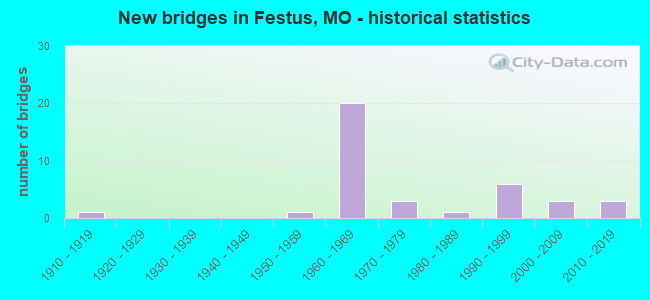
- New bridges - historical statistics
- 11910-1919
- 11950-1959
- 201960-1969
- 31970-1979
- 11980-1989
- 61990-1999
- 32000-2009
- 32010-2019
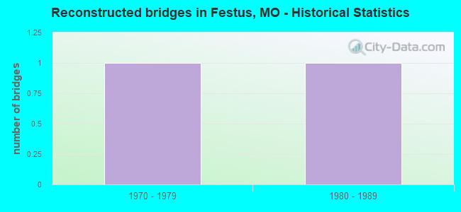
- Reconstructed bridges - Historical Statistics
- 11970-1979
- 11980-1989
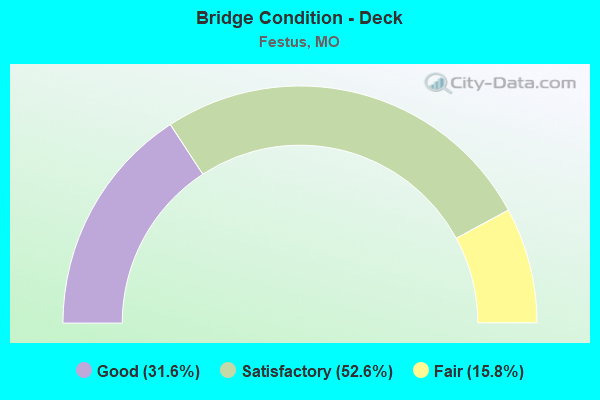
- Bridge Condition - Deck
- 31.6%Good
- 52.6%Satisfactory
- 15.8%Fair
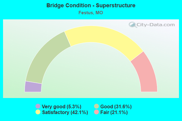
- Bridge Condition - Superstructure
- 5.3%Very good
- 31.6%Good
- 42.1%Satisfactory
- 21.1%Fair
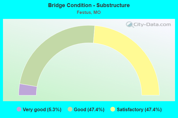
- Bridge Condition - Substructure
- 5.3%Very good
- 47.4%Good
- 47.4%Satisfactory
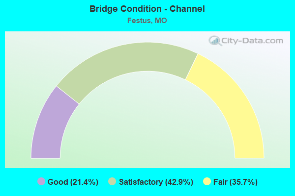
- Bridge Condition - Channel
- 21.4%Good
- 42.9%Satisfactory
- 35.7%Fair
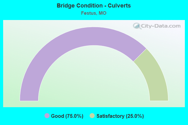
- Bridge Condition - Culverts
- 75.0%Good
- 25.0%Satisfactory
Find on map >> Show street view
Structure Number: 17147, Location: S 6 T 40 N R 6 E (Lat: 38.218711, Lng: -90.393328), Route carried "on" structure: City street , Year Built: 1996, Status: Posted for load, Structure Length: 1.25m (4.10ft), Average Daily Traffic: 9,070 (year 2021), Truck Traffic: 2%, Average Future Daily Traffic: 15,419 (year 2041), Design Load: HS 20+Mod, Features Intersected: TRIB OF PLATTIN CR, Facility Carried by Structure: S. MILL ST
Minimum Vertical Clearance: 30+ m (98+ ft), Kilometerpoint: 0.000, Lanes on structure: 2, Owner: City or Municipal Highway Agency, Approaching Roadway Width: 11.0m (36.1ft), Material/Design: Concrete continuous, Design/Construction: Culvert, Number Of Spans In Main Unit: 3, Length of Maximum Span: 3.7m (12.1ft), Curb-To-Curb Width: 16.8m (55.1ft), Out-to-Out Width: 21.9m (71.9ft)
Condition: Channel: Satisfactory, Culverts: Good, Operating Rating: 54.0 metric tons, Method Used To Determine Operating Rating: Load Factor (LF), Inventory Rating: 32.4 metric tons, Method Used To Determine Inventory Rating: Load Factor (LF), Structural Evaluation: Better than present minimum criteria, Deck Geometry: Superior to present desirable criteria, Waterway Adequacy: Superior to present desirable criteria, Approach Roadway Alignment: Equal to present desirable criteria, Designated Inspection Frequency: Every 24 months, Inspection Date: March 2021, Deck Structure Type: Concrete Cast-file-Place
Find on map >> Show street view
Structure Number: 1905, Location: S 1915 T 40 N R 6 E (Lat: 38.181400, Lng: -90.384542), Route carried "on" structure: Interstate 55, Year Built: 1969, Status: Open, Structure Length: 7.07m (23.20ft), Average Daily Traffic: 12,970 (year 2021), Truck Traffic: 22%, Average Future Daily Traffic: 23,995 (year 2041), Design Load: HS 20+Mod, Features Intersected: PLATTIN CR
Minimum Vertical Clearance: 30+ m (98+ ft), Kilometerpoint: 58.810, Lanes on structure: 2, Base Highway Network: Yes, Owner: State Highway Agency, Approaching Roadway Width: 11.6m (38.1ft), Material/Design: Steel continuous, Design/Construction: Stringer/Multi-beam, Number Of Spans In Main Unit: 3, Length of Maximum Span: 27.4m (89.9ft), Curb-To-Curb Width: 11.6m (38.1ft), Out-to-Out Width: 12.5m (41.0ft)
Condition: Deck: Satisfactory, Superstructure: Satisfactory, Substructure: Satisfactory, Channel: Good, Operating Rating: 57.6 metric tons, Method Used To Determine Operating Rating: Load Factor (LF), Inventory Rating: 34.2 metric tons, Method Used To Determine Inventory Rating: Load Factor (LF), Structural Evaluation: Equal to present minimum criteria, Deck Geometry: Equal to present minimum criteria, Waterway Adequacy: Equal to present desirable criteria, Approach Roadway Alignment: Equal to present desirable criteria, Designated Inspection Frequency: Every 24 months, Inspection Date: November 2020, Deck Structure Type: Concrete Cast-file-Place, Wearing Surface/Protective System: Wearing Surface: Latex Concrete, Membrane: Built-up
Find on map >> Show street view
Structure Number: 19507, Location: S 895 T 40 N R 5 E (Lat: 38.201319, Lng: -90.476028), Route carried "on" structure: County highway 239, Year Built: 1983, Status: Open, Structure Length: 6.55m (21.49ft), Average Daily Traffic: 500 (year 2021), Truck Traffic: 2%, Average Future Daily Traffic: 1,000 (year 2041), Design Load: H 15, Features Intersected: JOACHIM CR, Facility Carried by Structure: MEYER RD
Minimum Vertical Clearance: 30+ m (98+ ft), Kilometerpoint: 0.080, Lanes on structure: 2, Owner: County Highway Agency, Approaching Roadway Width: 6.1m (20.0ft), Material/Design: Steel continuous, Design/Construction: Stringer/Multi-beam, Number Of Spans In Main Unit: 3, Length of Maximum Span: 32.0m (105.0ft), Curb-To-Curb Width: 8.5m (27.9ft), Out-to-Out Width: 9.1m (29.9ft)
Condition: Deck: Satisfactory, Superstructure: Satisfactory, Substructure: Satisfactory, Channel: Satisfactory, Operating Rating: 41.4 metric tons, Method Used To Determine Operating Rating: Allowable Stress (AS), Inventory Rating: 25.2 metric tons, Method Used To Determine Inventory Rating: Allowable Stress (AS), Structural Evaluation: Equal to present minimum criteria, Deck Geometry: Somewhat better than minimum adequacy, Waterway Adequacy: Better than present minimum criteria, Approach Roadway Alignment: Equal to present minimum criteria, Designated Inspection Frequency: Every 24 months, Underwater Inspection Frequency: Every 60 months, Inspection Date: January 2021, Underwater Inspection Date: April 2021, Deck Structure Type: Concrete Cast-file-Place, Wearing Surface/Protective System: Wearing Surface: Monolithic Concrete
Find on map >> Show street view
Structure Number: 23196, Location: S 185 T 40 N R 6 E (Lat: 38.164461, Lng: -90.399608), Route carried "on" structure: County highway 228, Year Built: 1917, Year Reconstructed: 1983, Status: Open, Structure Length: 1.98m (6.50ft), Average Daily Traffic: 500 (year 2021), Truck Traffic: 5%, Average Future Daily Traffic: 1,000 (year 2041), Design Load: H 15, Features Intersected: TRIB OF PLATTIN CR, Facility Carried by Structure: PLATTIN RD
Minimum Vertical Clearance: 30+ m (98+ ft), Kilometerpoint: 2.816, Lanes on structure: 2, Owner: County Highway Agency, Approaching Roadway Width: 6.1m (20.0ft), Material/Design: Prestressed concrete, Design/Construction: Box Beam or Girders - Multiple, Number Of Spans In Main Unit: 1, Length of Maximum Span: 19.5m (64.0ft), Curb-To-Curb Width: 7.3m (24.0ft), Out-to-Out Width: 7.6m (24.9ft)
Condition: Deck: Fair, Superstructure: Fair, Substructure: Good, Channel: Fair, Operating Rating: 62.1 metric tons, Method Used To Determine Operating Rating: Allowable Stress (AS), Inventory Rating: 40.5 metric tons, Method Used To Determine Inventory Rating: Allowable Stress (AS), Structural Evaluation: Somewhat better than minimum adequacy, Deck Geometry: Meets minimum limits, Waterway Adequacy: Better than present minimum criteria, Approach Roadway Alignment: Equal to present minimum criteria, Designated Inspection Frequency: Every 24 months, Inspection Date: January 2021, Deck Structure Type: Concrete Precast Panels, Wearing Surface/Protective System: Wearing Surface: Bituminous
Find on map >> Show street view
Structure Number: 23511, Location: S 27 T 40 N R 5 E (Lat: 38.174108, Lng: -90.447831), Route carried "on" structure: County highway 225, Year Built: 1999, Status: Open, Structure Length: 1.55m (5.09ft), Average Daily Traffic: 191 (year 2021), Truck Traffic: 5%, Average Future Daily Traffic: 325 (year 2041), Design Load: HS 20, Features Intersected: BUCK CR, Facility Carried by Structure: MEYER RD
Minimum Vertical Clearance: 30+ m (98+ ft), Kilometerpoint: 4.506, Lanes on structure: 2, Owner: Local Agency, Approaching Roadway Width: 7.3m (24.0ft), Skew: 2 degrees, Material/Design: Prestressed concrete, Design/Construction: Stringer/Multi-beam, Number Of Spans In Main Unit: 1, Length of Maximum Span: 14.6m (47.9ft), Curb-To-Curb Width: 10.2m (33.5ft), Out-to-Out Width: 11.0m (36.1ft)
Condition: Deck: Good, Superstructure: Very good, Substructure: Satisfactory, Channel: Fair, Operating Rating: 73.8 metric tons, Method Used To Determine Operating Rating: Load Factor (LF), Inventory Rating: 40.5 metric tons, Method Used To Determine Inventory Rating: Load Factor (LF), Structural Evaluation: Equal to present minimum criteria, Deck Geometry: Better than present minimum criteria, Waterway Adequacy: Better than present minimum criteria, Approach Roadway Alignment: Equal to present desirable criteria, Designated Inspection Frequency: Every 24 months, Inspection Date: January 2021, Deck Structure Type: Concrete Cast-file-Place, Wearing Surface/Protective System: Wearing Surface: Monolithic Concrete, Deck Protection: Epoxy Coated Reinforcing
Find on map >> Show street view
Structure Number: 23547, Location: S 27 T 40 N R 5 E (Lat: 38.185433, Lng: -90.441133), Route carried "on" structure: County highway 140, Year Built: 1990, Status: Open, Structure Length: 1.65m (5.41ft), Average Daily Traffic: 500 (year 2021), Truck Traffic: 10%, Average Future Daily Traffic: 850 (year 2041), Features Intersected: BUCK CR BR - JOACH, Facility Carried by Structure: BUCK CREEK RD
Minimum Vertical Clearance: 30+ m (98+ ft), Kilometerpoint: 4.506, Lanes on structure: 2, Owner: Local Agency, Approaching Roadway Width: 7.0m (23.0ft), Skew: 4 degrees, Material/Design: Steel, Design/Construction: Stringer/Multi-beam, Number Of Spans In Main Unit: 1, Length of Maximum Span: 16.5m (54.1ft), Curb-To-Curb Width: 7.4m (24.3ft), Out-to-Out Width: 7.7m (25.3ft)
Condition: Deck: Fair, Superstructure: Fair, Substructure: Satisfactory, Channel: Fair, Operating Rating: 57.6 metric tons, Method Used To Determine Operating Rating: Allowable Stress (AS), Inventory Rating: 35.1 metric tons, Method Used To Determine Inventory Rating: Allowable Stress (AS), Structural Evaluation: Somewhat better than minimum adequacy, Deck Geometry: Meets minimum limits, Waterway Adequacy: Better than present minimum criteria, Approach Roadway Alignment: Equal to present minimum criteria, Designated Inspection Frequency: Every 24 months, Inspection Date: January 2021, Deck Structure Type: Concrete Cast-file-Place, Wearing Surface/Protective System: Wearing Surface: Bituminous
Find on map >> Show street view
Structure Number: 2488, Location: S 3 T 40 N R 5 E (Lat: 38.227231, Lng: -90.451639), Route carried "on" structure: State highway A, Year Built: 1979, Status: Open, Structure Length: 4.45m (14.60ft), Average Daily Traffic: 10,337 (year 2021), Truck Traffic: 6%, Average Future Daily Traffic: 17,573 (year 2041), Design Load: H 20, Features Intersected: LITTLE CR
Minimum Vertical Clearance: 30+ m (98+ ft), Kilometerpoint: 10.617, Lanes on structure: 2, Owner: State Highway Agency, Approaching Roadway Width: 7.3m (24.0ft), Skew: 4 degrees, Material/Design: Prestressed concrete continuous, Design/Construction: Stringer/Multi-beam, Number Of Spans In Main Unit: 3, Length of Maximum Span: 14.9m (48.9ft), Curb or Sidewalk Widths: Left: 0.2m (0.7ft), Right: 0.2m (0.7ft), Curb-To-Curb Width: 13.4m (44.0ft), Out-to-Out Width: 14.2m (46.6ft)
Condition: Deck: Satisfactory, Superstructure: Good, Substructure: Good, Channel: Satisfactory, Operating Rating: 63.0 metric tons, Method Used To Determine Operating Rating: Allowable Stress (AS), Inventory Rating: 37.8 metric tons, Method Used To Determine Inventory Rating: Allowable Stress (AS), Structural Evaluation: Better than present minimum criteria, Deck Geometry: Equal to present minimum criteria, Waterway Adequacy: Equal to present desirable criteria, Approach Roadway Alignment: Equal to present desirable criteria, Designated Inspection Frequency: Every 24 months, Inspection Date: November 2020, Deck Structure Type: Concrete Cast-file-Place, Wearing Surface/Protective System: Wearing Surface: Latex Concrete, Deck Protection: Epoxy Coated Reinforcing
Find on map >> Show street view
Structure Number: 249, Location: S 392 T 40 N R 5 E (Lat: 38.217356, Lng: -90.440225), Route carried "on" structure: State highway A, Year Built: 1974, Status: Open, Structure Length: 8.50m (27.89ft), Average Daily Traffic: 12,109 (year 2021), Truck Traffic: 4%, Average Future Daily Traffic: 20,585 (year 2041), Design Load: H 20, Features Intersected: JOACHIM CR
Minimum Vertical Clearance: 30+ m (98+ ft), Kilometerpoint: 12.107, Lanes on structure: 2, Owner: State Highway Agency, Approaching Roadway Width: 7.3m (24.0ft), Material/Design: Prestressed concrete continuous, Design/Construction: Stringer/Multi-beam, Number Of Spans In Main Unit: 5, Length of Maximum Span: 18.9m (62.0ft), Curb-To-Curb Width: 13.4m (44.0ft), Out-to-Out Width: 14.3m (46.9ft)
Condition: Deck: Good, Superstructure: Satisfactory, Substructure: Satisfactory, Channel: Fair, Operating Rating: 56.7 metric tons, Method Used To Determine Operating Rating: Load Factor (LF), Inventory Rating: 26.1 metric tons, Method Used To Determine Inventory Rating: Load Factor (LF), Structural Evaluation: Equal to present minimum criteria, Deck Geometry: Equal to present minimum criteria, Waterway Adequacy: Equal to present desirable criteria, Approach Roadway Alignment: Equal to present desirable criteria, Designated Inspection Frequency: Every 24 months, Inspection Date: November 2020, Deck Structure Type: Concrete Cast-file-Place, Wearing Surface/Protective System: Wearing Surface: Latex Concrete
Find on map >> Show street view
Structure Number: 29662, Location: S 1 T 40 N R 5 E (Lat: 38.231386, Lng: -90.421567), Route carried "on" structure: City street , Year Built: 2003, Status: Open, Structure Length: 7.01m (23.00ft), Average Daily Traffic: 2,000 (year 2021), Truck Traffic: 10%, Average Future Daily Traffic: 3,400 (year 2041), Design Load: HS 20, Features Intersected: JOACHIM CR, Facility Carried by Structure: OLD HWY A
Minimum Vertical Clearance: 30+ m (98+ ft), Kilometerpoint: 0.000, Lanes on structure: 2, Owner: City or Municipal Highway Agency, Approaching Roadway Width: 7.9m (25.9ft), Material/Design: Prestressed concrete continuous, Design/Construction: Stringer/Multi-beam, Number Of Spans In Main Unit: 3, Length of Maximum Span: 27.4m (89.9ft), Curb-To-Curb Width: 8.5m (27.9ft), Out-to-Out Width: 11.3m (37.1ft)
Condition: Deck: Good, Superstructure: Good, Substructure: Good, Channel: Good, Operating Rating: 62.1 metric tons, Method Used To Determine Operating Rating: Load Factor (LF), Inventory Rating: 36.9 metric tons, Method Used To Determine Inventory Rating: Load Factor (LF), Structural Evaluation: Better than present minimum criteria, Deck Geometry: Somewhat better than minimum adequacy, Waterway Adequacy: Equal to present desirable criteria, Approach Roadway Alignment: Better than present minimum criteria, Designated Inspection Frequency: Every 24 months, Inspection Date: March 2021, Deck Structure Type: Concrete Cast-file-Place, Wearing Surface/Protective System: Wearing Surface: Bituminous
Find on map >> Show street view
Structure Number: 33516, Location: S 416 T 40 N R 6 E (Lat: 38.224783, Lng: -90.405356), Route carried "on" structure: Interstate 55, Year Built: 2011, Status: Open, Structure Length: 8.58m (28.15ft), Average Daily Traffic: 57,085 (year 2021), Truck Traffic: 15%, Average Future Daily Traffic: 105,607 (year 2041), Features Intersected: CST FIFTH ST, BNSF RR
Minimum Vertical Clearance: 7.01m (23.00ft), Kilometerpoint: 53.382, Lanes on structure: 4, Lanes under structure: 2, Base Highway Network: Yes, Owner: State Highway Agency, Approaching Roadway Width: 14.3m (46.9ft), Material/Design: Steel continuous, Design/Construction: Stringer/Multi-beam, Number Of Spans In Main Unit: 3, Length of Maximum Span: 34.7m (113.8ft), Curb-To-Curb Width: 14.3m (46.9ft), Out-to-Out Width: 30.1m (98.8ft)
Condition: Deck: Good, Superstructure: Good, Substructure: Very good, Operating Rating: 67.5 metric tons, Method Used To Determine Operating Rating: Load Factor (LF), Inventory Rating: 40.5 metric tons, Method Used To Determine Inventory Rating: Load Factor (LF), Structural Evaluation: Better than present minimum criteria, Deck Geometry: High priority of replacement, Underclear: Meets minimum limits, Approach Roadway Alignment: Equal to present desirable criteria, Length Of Structure Improvement: 0.96m (3.15ft), Designated Inspection Frequency: Every 24 months, Inspection Date: November 2020, Bridge Improvement Cost: $1,362,000, Roadway Improvement Cost: $136,000, Total Project Cost: $2,043,000 ( Estimate for 2022), Deck Structure Type: Concrete Cast-file-Place, Wearing Surface/Protective System: Wearing Surface: Monolithic Concrete, Deck Protection: Epoxy Coated Reinforcing
Find on map >> Show street view
Structure Number: 34446, Location: S 5 T 40 N R 5 E (Lat: 38.229050, Lng: -90.484528), Route carried "on" structure: County highway 250, Year Built: 2014, Status: Open, Structure Length: 4.30m (14.11ft), Average Daily Traffic: 700 (year 2021), Truck Traffic: 5%, Average Future Daily Traffic: 1,400 (year 2041), Features Intersected: LITTLE CR, Facility Carried by Structure: M'VILLE HEMATITE
Minimum Vertical Clearance: 30+ m (98+ ft), Kilometerpoint: 0.000, Lanes on structure: 2, Owner: County Highway Agency, Approaching Roadway Width: 11.0m (36.1ft), Skew: 3 degrees, Material/Design: Prestressed concrete continuous, Design/Construction: Stringer/Multi-beam, Number Of Spans In Main Unit: 2, Length of Maximum Span: 21.3m (69.9ft), Curb-To-Curb Width: 11.0m (36.1ft), Out-to-Out Width: 11.9m (39.0ft)
Condition: Deck: Good, Superstructure: Good, Substructure: Good, Channel: Satisfactory, Operating Rating: 60.3 metric tons, Method Used To Determine Operating Rating: Load Factor (LF), Inventory Rating: 46.8 metric tons, Method Used To Determine Inventory Rating: Load Factor (LF), Structural Evaluation: Better than present minimum criteria, Deck Geometry: Better than present minimum criteria, Waterway Adequacy: Equal to present desirable criteria, Approach Roadway Alignment: Equal to present minimum criteria, Designated Inspection Frequency: Every 24 months, Inspection Date: January 2021, Deck Structure Type: Concrete Cast-file-Place, Wearing Surface/Protective System: Wearing Surface: Monolithic Concrete, Deck Protection: Epoxy Coated Reinforcing
Find on map >> Show street view
Structure Number: 34447, Location: S 5 T 40 N R 5 E (Lat: 38.230300, Lng: -90.484150), Route carried "on" structure: County highway 141, Year Built: 2014, Status: Open, Structure Length: 0.80m (2.62ft), Average Daily Traffic: 700 (year 2021), Truck Traffic: 5%, Average Future Daily Traffic: 1,400 (year 2041), Features Intersected: TRIB TO LITTLE CR, Facility Carried by Structure: M'VILLE HEMATITE
Minimum Vertical Clearance: 30+ m (98+ ft), Kilometerpoint: 0.000, Lanes on structure: 2, Owner: County Highway Agency, Approaching Roadway Width: 11.0m (36.1ft), Skew: 4 degrees, Material/Design: Concrete, Design/Construction: Culvert, Number Of Spans In Main Unit: 2, Length of Maximum Span: 3.9m (12.8ft), Curb-To-Curb Width: 12.2m (40.0ft), Out-to-Out Width: 13.2m (43.3ft)
Condition: Channel: Satisfactory, Culverts: Good, Operating Rating: 45.9 metric tons, Method Used To Determine Operating Rating: Load Factor (LF), Inventory Rating: 35.1 metric tons, Method Used To Determine Inventory Rating: Load Factor (LF), Structural Evaluation: Better than present minimum criteria, Deck Geometry: Equal to present desirable criteria, Waterway Adequacy: Equal to present minimum criteria, Approach Roadway Alignment: Better than present minimum criteria, Designated Inspection Frequency: Every 24 months, Inspection Date: January 2021, Deck Structure Type: Concrete Cast-file-Place
Find on map >> Show street view
Structure Number: 34882, Location: S 1888 T 40 N R 6 E (Lat: 38.152111, Lng: -90.401972), Route carried "on" structure: County highway 227, Year Built: 2005, Status: Open, Structure Length: 0.77m (2.53ft), Average Daily Traffic: 425 (year 2021), Truck Traffic: 5%, Average Future Daily Traffic: 850 (year 2041), Features Intersected: TRIB TO PLATTIN CR, Facility Carried by Structure: PLATTIN RD
Minimum Vertical Clearance: 30+ m (98+ ft), Kilometerpoint: 2.736, Lanes on structure: 2, Owner: County Highway Agency, Approaching Roadway Width: 8.4m (27.6ft), Skew: 5 degrees, Material/Design: Concrete, Design/Construction: Culvert, Number Of Spans In Main Unit: 1, Length of Maximum Span: 7.7m (25.3ft), Curb-To-Curb Width: 8.4m (27.6ft), Out-to-Out Width: 9.0m (29.5ft)
Condition: Channel: Good, Culverts: Satisfactory, Operating Rating: 24.3 metric tons, Method Used To Determine Operating Rating: Field evaluation and documented engineering judgment, Inventory Rating: 14.4 metric tons, Method Used To Determine Inventory Rating: Field evaluation and documented engineering judgment, Structural Evaluation: Meets minimum limits, Deck Geometry: Somewhat better than minimum adequacy, Waterway Adequacy: Equal to present desirable criteria, Approach Roadway Alignment: Equal to present desirable criteria, Designated Inspection Frequency: Every 24 months, Inspection Date: January 2021, Deck Structure Type: Concrete Cast-file-Place, Wearing Surface/Protective System: Wearing Surface: Bituminous
Find on map >> Show street view
Structure Number: 36355, Location: S 6 T 40 N R 6 E (Lat: 38.219028, Lng: -90.397111), Route carried "on" structure: City street , Year Built: 2007, Status: Posted for load, Structure Length: 0.78m (2.56ft), Average Daily Traffic: 4,546 (year 2021), Truck Traffic: 4%, Average Future Daily Traffic: 7,728 (year 2041), Design Load: HS 20, Features Intersected: TRIB OF PLATTIN CR, Facility Carried by Structure: W MAIN ST
Minimum Vertical Clearance: 30+ m (98+ ft), Kilometerpoint: 0.000, Lanes on structure: 2, Owner: City or Municipal Highway Agency, Approaching Roadway Width: 9.1m (29.9ft), Skew: 4 degrees, Material/Design: Concrete, Design/Construction: Culvert, Number Of Spans In Main Unit: 2, Length of Maximum Span: 2.7m (8.9ft), Curb or Sidewalk Widths: Left: 1.2m (3.9ft), Right: 1.2m (3.9ft), Curb-To-Curb Width: 9.1m (29.9ft), Out-to-Out Width: 11.6m (38.1ft)
Condition: Channel: Satisfactory, Culverts: Good, Inventory Rating: 89.1 metric tons, Method Used To Determine Inventory Rating: Load Factor (LF), Structural Evaluation: Better than present minimum criteria, Deck Geometry: Meets minimum limits, Waterway Adequacy: Superior to present desirable criteria, Approach Roadway Alignment: Equal to present desirable criteria, Designated Inspection Frequency: Every 24 months, Inspection Date: March 2021
Find on map >> Show street view
Structure Number: 4119, Location: S 1915 T 40 N R 6 E (Lat: 38.178181, Lng: -90.388733), Route carried "on" structure: US 61, Year Built: 1993, Status: Open, Structure Length: 8.66m (28.41ft), Average Daily Traffic: 2,681 (year 2021), Truck Traffic: 15%, Average Future Daily Traffic: 4,826 (year 2041), Design Load: HS 20+Mod, Features Intersected: PLATTIN CR
Minimum Vertical Clearance: 30+ m (98+ ft), Kilometerpoint: 324.971, Lanes on structure: 2, Owner: State Highway Agency, Approaching Roadway Width: 12.2m (40.0ft), Material/Design: Steel continuous, Design/Construction: Stringer/Multi-beam, Number Of Spans In Main Unit: 4, Length of Maximum Span: 29.9m (98.1ft), Curb or Sidewalk Widths: Left: 0.2m (0.7ft), Right: 0.2m (0.7ft), Curb-To-Curb Width: 11.8m (38.7ft), Out-to-Out Width: 12.6m (41.3ft)
Condition: Deck: Satisfactory, Superstructure: Good, Substructure: Good, Channel: Fair, Operating Rating: 65.7 metric tons, Method Used To Determine Operating Rating: Allowable Stress (AS), Inventory Rating: 38.7 metric tons, Method Used To Determine Inventory Rating: Allowable Stress (AS), Structural Evaluation: Better than present minimum criteria, Deck Geometry: Somewhat better than minimum adequacy, Waterway Adequacy: Equal to present desirable criteria, Approach Roadway Alignment: Equal to present desirable criteria, Designated Inspection Frequency: Every 24 months, Inspection Date: November 2020, Deck Structure Type: Concrete Cast-file-Place, Wearing Surface/Protective System: Wearing Surface: Monolithic Concrete, Deck Protection: Epoxy Coated Reinforcing
Find on map >> Show street view
Structure Number: 569, Location: S 416 T 40 N R 6 E (Lat: 38.227581, Lng: -90.404642), Route carried "on" structure: Interstate 55, Year Built: 1966, Status: Open, Structure Length: 4.97m (16.31ft), Average Daily Traffic: 28,363 (year 2021), Truck Traffic: 15%, Average Future Daily Traffic: 52,472 (year 2041), Design Load: HS 20+Mod, Features Intersected: CST CENTRAL AVE
Minimum Vertical Clearance: 30+ m (98+ ft), Kilometerpoint: 53.088, Lanes on structure: 2, Lanes under structure: 3, Base Highway Network: Yes, Owner: State Highway Agency, Approaching Roadway Width: 11.6m (38.1ft), Skew: 1 degrees, Material/Design: Concrete continuous, Design/Construction: Slab, Number Of Spans In Main Unit: 3, Length of Maximum Span: 18.3m (60.0ft), Curb-To-Curb Width: 11.4m (37.4ft), Out-to-Out Width: 12.3m (40.4ft)
Condition: Deck: Satisfactory, Superstructure: Satisfactory, Substructure: Good, Operating Rating: 65.7 metric tons, Method Used To Determine Operating Rating: Load Factor (LF), Inventory Rating: 39.6 metric tons, Method Used To Determine Inventory Rating: Load Factor (LF), Structural Evaluation: Equal to present minimum criteria, Deck Geometry: Somewhat better than minimum adequacy, Underclear: Superior to present desirable criteria, Approach Roadway Alignment: Equal to present desirable criteria, Designated Inspection Frequency: Every 24 months, Inspection Date: November 2020, Deck Structure Type: Concrete Cast-file-Place, Wearing Surface/Protective System: Wearing Surface: Other
Find on map >> Show street view
Structure Number: 57, Location: S 23 T 56 N R 35 W (Lat: 39.652017, Lng: -94.788019), Route carried "on" structure: County highway , Year Built: 1958, Status: Open, Structure Length: 7.32m (24.02ft), Average Daily Traffic: 190 (year 2021), Truck Traffic: 11%, Average Future Daily Traffic: 247 (year 2041), Design Load: H 15, Features Intersected: IS 29, Facility Carried by Structure: SE 40 E
Minimum Vertical Clearance: 30+ m (98+ ft), Kilometerpoint: 0.454, Lanes on structure: 2, Lanes under structure: 4, Owner: State Highway Agency, Approaching Roadway Width: 6.1m (20.0ft), Skew: 1 degrees, Material/Design: Steel continuous, Design/Construction: Stringer/Multi-beam, Number Of Spans In Main Unit: 4, Length of Maximum Span: 18.6m (61.0ft), Curb-To-Curb Width: 7.3m (24.0ft), Out-to-Out Width: 8.1m (26.6ft)
Condition: Deck: Good, Superstructure: Good, Substructure: Satisfactory, Operating Rating: 31.5 metric tons, Method Used To Determine Operating Rating: Load Factor (LF), Inventory Rating: 18.9 metric tons, Method Used To Determine Inventory Rating: Load Factor (LF), Structural Evaluation: Somewhat better than minimum adequacy, Deck Geometry: Somewhat better than minimum adequacy, Underclear: Somewhat better than minimum adequacy, Approach Roadway Alignment: Meets minimum limits, Designated Inspection Frequency: Every 24 months, Inspection Date: August 2020, Deck Structure Type: Concrete Cast-file-Place, Wearing Surface/Protective System: Wearing Surface: Monolithic Concrete
Find on map >> Show street view
Structure Number: 57, Location: S 416 T 40 N R 6 E (Lat: 38.227494, Lng: -90.404403), Route carried "on" structure: Interstate 55, Year Built: 1966, Status: Open, Structure Length: 4.97m (16.31ft), Average Daily Traffic: 28,722 (year 2021), Truck Traffic: 17%, Average Future Daily Traffic: 53,136 (year 2041), Design Load: HS 20+Mod, Features Intersected: CST CENTRAL AVE
Minimum Vertical Clearance: 30+ m (98+ ft), Kilometerpoint: 284.553, Lanes on structure: 2, Lanes under structure: 3, Base Highway Network: Yes, Owner: State Highway Agency, Approaching Roadway Width: 11.6m (38.1ft), Skew: 1 degrees, Material/Design: Concrete continuous, Design/Construction: Slab, Number Of Spans In Main Unit: 3, Length of Maximum Span: 18.3m (60.0ft), Curb-To-Curb Width: 11.4m (37.4ft), Out-to-Out Width: 12.3m (40.4ft)
Condition: Deck: Satisfactory, Superstructure: Fair, Substructure: Good, Operating Rating: 65.7 metric tons, Method Used To Determine Operating Rating: Load Factor (LF), Inventory Rating: 39.6 metric tons, Method Used To Determine Inventory Rating: Load Factor (LF), Structural Evaluation: Somewhat better than minimum adequacy, Deck Geometry: Somewhat better than minimum adequacy, Underclear: Superior to present desirable criteria, Approach Roadway Alignment: Equal to present desirable criteria, Designated Inspection Frequency: Every 24 months, Inspection Date: November 2020, Deck Structure Type: Concrete Cast-file-Place, Wearing Surface/Protective System: Wearing Surface: Other
Find on map >> Show street view
Structure Number: 572, Location: S 1906 T 40 N R 6 E (Lat: 38.197178, Lng: -90.400167), Route carried "on" structure: Interstate 55, Year Built: 1966, Status: Open, Structure Length: 6.10m (20.01ft), Average Daily Traffic: 22,270 (year 2021), Truck Traffic: 15%, Average Future Daily Traffic: 41,200 (year 2041), Design Load: HS 20+Mod, Features Intersected: US 67
Minimum Vertical Clearance: 30+ m (98+ ft), Kilometerpoint: 56.577, Lanes on structure: 3, Lanes under structure: 6, Base Highway Network: Yes, Owner: State Highway Agency, Approaching Roadway Width: 11.6m (38.1ft), Material/Design: Steel continuous, Design/Construction: Stringer/Multi-beam, Number Of Spans In Main Unit: 4, Length of Maximum Span: 16.8m (55.1ft), Curb-To-Curb Width: 12.5m (41.0ft), Out-to-Out Width: 13.3m (43.6ft)
Condition: Deck: Satisfactory, Superstructure: Satisfactory, Substructure: Satisfactory, Operating Rating: 56.7 metric tons, Method Used To Determine Operating Rating: Load Factor (LF), Inventory Rating: 34.2 metric tons, Method Used To Determine Inventory Rating: Load Factor (LF), Structural Evaluation: Equal to present minimum criteria, Deck Geometry: Meets minimum limits, Underclear: Meets minimum limits, Approach Roadway Alignment: Equal to present desirable criteria, Designated Inspection Frequency: Every 24 months, Inspection Date: November 2020, Deck Structure Type: Concrete Cast-file-Place, Wearing Surface/Protective System: Wearing Surface: Latex Concrete, Membrane: Built-up
Find on map >> Show street view
Structure Number: 573, Location: S 1906 T 40 N R 6 E (Lat: 38.197328, Lng: -90.399903), Route carried "on" structure: Interstate 55, Year Built: 1966, Status: Open, Structure Length: 6.10m (20.01ft), Average Daily Traffic: 13,069 (year 2021), Truck Traffic: 27%, Average Future Daily Traffic: 24,178 (year 2041), Design Load: HS 20+Mod, Features Intersected: US 67
Minimum Vertical Clearance: 30+ m (98+ ft), Kilometerpoint: 281.087, Lanes on structure: 3, Lanes under structure: 6, Base Highway Network: Yes, Owner: State Highway Agency, Approaching Roadway Width: 11.6m (38.1ft), Material/Design: Steel continuous, Design/Construction: Stringer/Multi-beam, Number Of Spans In Main Unit: 4, Length of Maximum Span: 16.8m (55.1ft), Curb-To-Curb Width: 12.5m (41.0ft), Out-to-Out Width: 13.3m (43.6ft)
Condition: Deck: Satisfactory, Superstructure: Satisfactory, Substructure: Satisfactory, Operating Rating: 56.7 metric tons, Method Used To Determine Operating Rating: Load Factor (LF), Inventory Rating: 34.2 metric tons, Method Used To Determine Inventory Rating: Load Factor (LF), Structural Evaluation: Equal to present minimum criteria, Deck Geometry: Meets minimum limits, Underclear: Meets minimum limits, Approach Roadway Alignment: Equal to present desirable criteria, Designated Inspection Frequency: Every 24 months, Inspection Date: November 2020, Deck Structure Type: Concrete Cast-file-Place, Wearing Surface/Protective System: Wearing Surface: Latex Concrete, Membrane: Built-up
Find on map >> Show street view
Structure Number: 601, Location: S 416 T 40 N R 6 E (Lat: 38.221583, Lng: -90.406436), Route carried "on" structure: Interstate 55, Year Built: 1966, Status: Open, Structure Length: 4.18m (13.71ft), Average Daily Traffic: 28,363 (year 2021), Truck Traffic: 15%, Average Future Daily Traffic: 52,472 (year 2041), Design Load: HS 20+Mod, Features Intersected: CST THIRD ST
Minimum Vertical Clearance: 30+ m (98+ ft), Kilometerpoint: 53.781, Lanes on structure: 2, Lanes under structure: 2, Base Highway Network: Yes, Owner: State Highway Agency, Approaching Roadway Width: 11.6m (38.1ft), Material/Design: Concrete continuous, Design/Construction: Slab, Number Of Spans In Main Unit: 3, Length of Maximum Span: 15.2m (49.9ft), Curb-To-Curb Width: 11.4m (37.4ft), Out-to-Out Width: 12.3m (40.4ft)
Condition: Deck: Fair, Superstructure: Fair, Substructure: Good, Operating Rating: 71.1 metric tons, Method Used To Determine Operating Rating: Load Factor (LF), Inventory Rating: 43.2 metric tons, Method Used To Determine Inventory Rating: Load Factor (LF), Structural Evaluation: Somewhat better than minimum adequacy, Deck Geometry: Somewhat better than minimum adequacy, Underclear: Better than present minimum criteria, Approach Roadway Alignment: Equal to present desirable criteria, Designated Inspection Frequency: Every 24 months, Inspection Date: November 2020, Deck Structure Type: Concrete Cast-file-Place, Wearing Surface/Protective System: Wearing Surface: Other
Find on map >> Show street view
Structure Number: 602, Location: S 416 T 40 N R 6 E (Lat: 38.221556, Lng: -90.406222), Route carried "on" structure: Interstate 55, Year Built: 1966, Status: Open, Structure Length: 4.18m (13.71ft), Average Daily Traffic: 28,722 (year 2021), Truck Traffic: 17%, Average Future Daily Traffic: 53,136 (year 2041), Design Load: HS 20+Mod, Features Intersected: CST THIRD ST
Minimum Vertical Clearance: 30+ m (98+ ft), Kilometerpoint: 283.882, Lanes on structure: 2, Lanes under structure: 2, Base Highway Network: Yes, Owner: State Highway Agency, Approaching Roadway Width: 11.6m (38.1ft), Material/Design: Concrete continuous, Design/Construction: Slab, Number Of Spans In Main Unit: 3, Length of Maximum Span: 15.2m (49.9ft), Curb-To-Curb Width: 11.4m (37.4ft), Out-to-Out Width: 12.3m (40.4ft)
Condition: Deck: Satisfactory, Superstructure: Satisfactory, Substructure: Good, Operating Rating: 71.1 metric tons, Method Used To Determine Operating Rating: Load Factor (LF), Inventory Rating: 43.2 metric tons, Method Used To Determine Inventory Rating: Load Factor (LF), Structural Evaluation: Equal to present minimum criteria, Deck Geometry: Somewhat better than minimum adequacy, Underclear: Better than present minimum criteria, Approach Roadway Alignment: Equal to present desirable criteria, Designated Inspection Frequency: Every 24 months, Inspection Date: November 2020, Deck Structure Type: Concrete Cast-file-Place, Wearing Surface/Protective System: Wearing Surface: Other
Find on map >> Show street view
Structure Number: 603, Location: S 416 T 40 N R 6 E (Lat: 38.219506, Lng: -90.406453), Route carried "on" structure: City street , Year Built: 1966, Year Reconstructed: 1987, Status: Open, Structure Length: 6.43m (21.10ft), Average Daily Traffic: 4,544 (year 2021), Truck Traffic: 3%, Average Future Daily Traffic: 7,725 (year 2041), Design Load: H 20, Features Intersected: IS 55, Facility Carried by Structure: W MAIN ST E
Minimum Vertical Clearance: 30+ m (98+ ft), Kilometerpoint: 1.362, Lanes on structure: 2, Lanes under structure: 4, Owner: State Highway Agency, Approaching Roadway Width: 6.7m (22.0ft), Material/Design: Concrete continuous, Design/Construction: Slab, Number Of Spans In Main Unit: 4, Length of Maximum Span: 19.5m (64.0ft), Curb or Sidewalk Widths: Left: 1.4m (4.6ft), Right: 1.4m (4.6ft), Curb-To-Curb Width: 10.1m (33.1ft), Out-to-Out Width: 13.3m (43.6ft)
Condition: Deck: Satisfactory, Superstructure: Satisfactory, Substructure: Satisfactory, Operating Rating: 46.8 metric tons, Method Used To Determine Operating Rating: Allowable Stress (AS), Inventory Rating: 26.1 metric tons, Method Used To Determine Inventory Rating: Allowable Stress (AS), Structural Evaluation: Equal to present minimum criteria, Deck Geometry: Meets minimum limits, Underclear: Meets minimum limits, Approach Roadway Alignment: Equal to present desirable criteria, Designated Inspection Frequency: Every 24 months, Inspection Date: November 2020, Deck Structure Type: Concrete Cast-file-Place, Wearing Surface/Protective System: Wearing Surface: Latex Concrete, Membrane: Built-up
Find on map >> Show street view
Structure Number: 11898, Location: S 194 T 40 N R 6 E (Lat: 38.213381, Lng: -90.405536), Route carried "under" structure: Interstate 55, Year Built: 1999, Structure Length: 0. m, Average Daily Traffic: 28,363 (year 2021), Truck Traffic: 15%, Features Intersected: IS 55, Facility Carried by Structure: RT A E
Minimum Vertical Clearance: 5.59m (18.34ft), Kilometerpoint: 54.716, Lanes on structure: 6, Lanes under structure: 2, Material/Design: Prestressed concrete continuous, Design/Construction: Stringer/Multi-beam, Length of Maximum Span: 25.9m (85.0ft)
Find on map >> Show street view
Structure Number: 11898, Location: S 194 T 40 N R 6 E (Lat: 38.213381, Lng: -90.405536), Route carried "under" structure: Interstate 55, Year Built: 1999, Structure Length: 0. m, Average Daily Traffic: 22,793 (year 2021), Truck Traffic: 17%, Features Intersected: IS 55, Facility Carried by Structure: RT A E
Minimum Vertical Clearance: 5.23m (17.16ft), Kilometerpoint: 282.991, Lanes on structure: 6, Lanes under structure: 2, Material/Design: Prestressed concrete continuous, Design/Construction: Stringer/Multi-beam, Length of Maximum Span: 25.9m (85.0ft)
Find on map >> Show street view
Structure Number: 2489, Location: S 910 T 40 N R 5 E (Lat: 38.218239, Lng: -90.441922), Route carried "under" structure: County highway , Year Built: 1974, Structure Length: 0. m, Average Daily Traffic: 464 (year 2021), Truck Traffic: 4%, Features Intersected: CRD STATE HWY 21A OLD, Facility Carried by Structure: RT A E
Minimum Vertical Clearance: 7.01m (23.00ft), Kilometerpoint: 0.412, Lanes on structure: 2, Lanes under structure: 2, Material/Design: Prestressed concrete continuous, Design/Construction: Stringer/Multi-beam, Length of Maximum Span: 18.9m (62.0ft)
Find on map >> Show street view
Structure Number: 569, Location: S 416 T 40 N R 6 E (Lat: 38.227581, Lng: -90.404642), Route carried "under" structure: City street , Year Built: 1966, Structure Length: 0. m, Average Daily Traffic: 2,250 (year 2021), Truck Traffic: 4%, Features Intersected: CST CENTRAL AVE, Facility Carried by Structure: IS 55 S
Minimum Vertical Clearance: 5.38m (17.65ft), Kilometerpoint: 0.233, Lanes on structure: 2, Lanes under structure: 3, Material/Design: Concrete continuous, Design/Construction: Slab, Length of Maximum Span: 18.3m (60.0ft)
Find on map >> Show street view
Structure Number: 57, Location: S 416 T 40 N R 6 E (Lat: 38.227494, Lng: -90.404403), Route carried "under" structure: City street , Year Built: 1966, Structure Length: 0. m, Average Daily Traffic: 2,250 (year 2021), Truck Traffic: 4%, Features Intersected: CST CENTRAL AVE, Facility Carried by Structure: IS 55 N
Minimum Vertical Clearance: 5.44m (17.85ft), Kilometerpoint: 0.254, Lanes on structure: 2, Lanes under structure: 3, Material/Design: Concrete continuous, Design/Construction: Slab, Length of Maximum Span: 18.3m (60.0ft)
Find on map >> Show street view
Structure Number: 572, Location: S 1906 T 40 N R 6 E (Lat: 38.197178, Lng: -90.400167), Route carried "under" structure: US 67, Year Built: 1966, Structure Length: 0. m, Average Daily Traffic: 16,901 (year 2021), Truck Traffic: 8%, Features Intersected: US 67, Facility Carried by Structure: IS 55 S
Minimum Vertical Clearance: 4.60m (15.09ft), Kilometerpoint: 218.919, Lanes on structure: 3, Lanes under structure: 3, Material/Design: Steel continuous, Design/Construction: Stringer/Multi-beam, Length of Maximum Span: 16.8m (55.1ft)
Find on map >> Show street view
Structure Number: 572, Location: S 1906 T 40 N R 6 E (Lat: 38.197178, Lng: -90.400167), Route carried "under" structure: US 67, Year Built: 1966, Structure Length: 0. m, Average Daily Traffic: 17,236 (year 2021), Truck Traffic: 9%, Features Intersected: US 67, Facility Carried by Structure: IS 55 S
Minimum Vertical Clearance: 4.78m (15.68ft), Kilometerpoint: 99.195, Lanes on structure: 3, Lanes under structure: 3, Material/Design: Steel continuous, Design/Construction: Stringer/Multi-beam, Length of Maximum Span: 16.8m (55.1ft)
Find on map >> Show street view
Structure Number: 573, Location: S 1906 T 40 N R 6 E (Lat: 38.197328, Lng: -90.399903), Route carried "under" structure: US 67, Year Built: 1966, Structure Length: 0. m, Average Daily Traffic: 7,666 (year 2021), Truck Traffic: 9%, Features Intersected: US 67, Facility Carried by Structure: IS 55 N
Minimum Vertical Clearance: 4.78m (15.68ft), Kilometerpoint: 99.166, Lanes on structure: 3, Lanes under structure: 3, Material/Design: Steel continuous, Design/Construction: Stringer/Multi-beam, Length of Maximum Span: 16.8m (55.1ft)
Find on map >> Show street view
Structure Number: 573, Location: S 1906 T 40 N R 6 E (Lat: 38.197328, Lng: -90.399903), Route carried "under" structure: US 67, Year Built: 1966, Structure Length: 0. m, Average Daily Traffic: 16,901 (year 2021), Truck Traffic: 8%, Features Intersected: US 67, Facility Carried by Structure: IS 55 N
Minimum Vertical Clearance: 4.78m (15.68ft), Kilometerpoint: 218.948, Lanes on structure: 3, Lanes under structure: 3, Material/Design: Steel continuous, Design/Construction: Stringer/Multi-beam, Length of Maximum Span: 16.8m (55.1ft)
Find on map >> Show street view
Structure Number: 601, Location: S 416 T 40 N R 6 E (Lat: 38.221583, Lng: -90.406436), Route carried "under" structure: City street , Year Built: 1966, Structure Length: 0. m, Average Daily Traffic: 1,168 (year 2021), Truck Traffic: 5%, Features Intersected: CST THIRD ST, Facility Carried by Structure: IS 55 S
Minimum Vertical Clearance: 4.72m (15.49ft), Kilometerpoint: 0.472, Lanes on structure: 2, Lanes under structure: 2, Material/Design: Concrete continuous, Design/Construction: Slab, Length of Maximum Span: 15.2m (49.9ft)
Find on map >> Show street view
Structure Number: 602, Location: S 416 T 40 N R 6 E (Lat: 38.221556, Lng: -90.406222), Route carried "under" structure: City street , Year Built: 1966, Structure Length: 0. m, Average Daily Traffic: 1,168 (year 2021), Truck Traffic: 5%, Features Intersected: CST THIRD ST, Facility Carried by Structure: IS 55 N
Minimum Vertical Clearance: 4.85m (15.91ft), Kilometerpoint: 0.494, Lanes on structure: 2, Lanes under structure: 2, Material/Design: Concrete continuous, Design/Construction: Slab, Length of Maximum Span: 15.2m (49.9ft)
Find on map >> Show street view
Structure Number: 603, Location: S 416 T 40 N R 6 E (Lat: 38.219506, Lng: -90.406453), Route carried "under" structure: Interstate 55, Year Built: 1966, Structure Length: 0. m, Average Daily Traffic: 28,363 (year 2021), Truck Traffic: 15%, Features Intersected: IS 55, Facility Carried by Structure: W MAIN ST E
Minimum Vertical Clearance: 5.92m (19.42ft), Kilometerpoint: 54.032, Lanes on structure: 2, Lanes under structure: 2, Material/Design: Concrete continuous, Design/Construction: Slab, Length of Maximum Span: 19.5m (64.0ft)
Find on map >> Show street view
Structure Number: 603, Location: S 416 T 40 N R 6 E (Lat: 38.219506, Lng: -90.406453), Route carried "under" structure: Interstate 55, Year Built: 1966, Structure Length: 0. m, Average Daily Traffic: 28,722 (year 2021), Truck Traffic: 17%, Features Intersected: IS 55, Facility Carried by Structure: W MAIN ST E
Minimum Vertical Clearance: 5.77m (18.93ft), Kilometerpoint: 283.675, Lanes on structure: 2, Lanes under structure: 2, Material/Design: Concrete continuous, Design/Construction: Slab, Length of Maximum Span: 19.5m (64.0ft)
Find on map >> Show street view
Structure Number: 964, Location: S 1986 T 41 N R 6 E (Lat: 38.234631, Lng: -90.403364), Route carried "under" structure: Interstate 55, Year Built: 1966, Structure Length: 0. m, Average Daily Traffic: 28,363 (year 2021), Truck Traffic: 15%, Features Intersected: IS 55, Facility Carried by Structure: PVT MANLEY QUARRY
Minimum Vertical Clearance: 4.85m (15.91ft), Kilometerpoint: 52.325, Lanes on structure: 2, Lanes under structure: 2, Material/Design: Concrete continuous, Design/Construction: Box Beam or Girders - Single/Spread, Length of Maximum Span: 20.1m (65.9ft)
Find on map >> Show street view
Structure Number: 964, Location: S 1986 T 41 N R 6 E (Lat: 38.234631, Lng: -90.403364), Route carried "under" structure: Interstate 55, Year Built: 1966, Structure Length: 0. m, Average Daily Traffic: 28,722 (year 2021), Truck Traffic: 17%, Features Intersected: IS 55, Facility Carried by Structure: PVT MANLEY QUARRY
Minimum Vertical Clearance: 4.90m (16.08ft), Kilometerpoint: 285.376, Lanes on structure: 2, Lanes under structure: 2, Material/Design: Concrete continuous, Design/Construction: Box Beam or Girders - Single/Spread, Length of Maximum Span: 20.1m (65.9ft)