Bridge Statistics for Fairdale, Kentucky (KY)
Condition, Traffic, Stress, Structural Evaluation, Project Costs
- National Bridge Inventory (NBI) Statistics
- 22Number of bridges
- 164ft / 50.1mTotal length
- $3,820,000Total costs
- 407,062Total average daily traffic
- 31,296Total average daily truck traffic
- National Bridge Inventory (NBI) Registered Bridges for Fairdale
- No street view available for this location
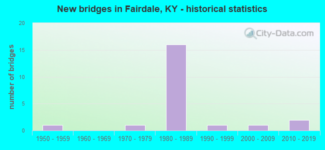
- New bridges - historical statistics
- 11950-1959
- 11970-1979
- 161980-1989
- 11990-1999
- 12000-2009
- 22010-2019


- Bridge Condition - Deck
- 12.5%Good
- 62.5%Satisfactory
- 25.0%Fair

- Bridge Condition - Superstructure
- 12.5%Very good
- 12.5%Good
- 62.5%Satisfactory
- 12.5%Fair

- Bridge Condition - Substructure
- 25.0%Good
- 75.0%Satisfactory

- Bridge Condition - Channel
- 8.3%Very good
- 8.3%Good
- 41.7%Satisfactory
- 33.3%Fair
- 8.3%Poor

- Bridge Condition - Culverts
- 33.3%Good
- 33.3%Satisfactory
- 33.3%Fair
Find on map >> Show street view
Structure Number: 56B00069N, Location: 0.1 MI N OF KY 1865 (Lat: 38.111667, Lng: -85.768611), Route carried "on" structure: State highway 2055, Year Built: 1950, Status: Open, Structure Length: 0.73m (2.40ft), Average Daily Traffic: 1,263 (year 2020), Truck Traffic: 4%, Average Future Daily Traffic: 1,174 (year 2040), Features Intersected: BEE LICK CREEK
Minimum Vertical Clearance: 30+ m (98+ ft), Kilometerpoint: 3.394, Lanes on structure: 2, Owner: State Highway Agency, Approaching Roadway Width: 6.2m (20.3ft), Skew: 3 degrees, Material/Design: Concrete, Design/Construction: Culvert, Number Of Spans In Main Unit: 2, Length of Maximum Span: 3.4m (11.2ft), Curb-To-Curb Width: 8.1m (26.6ft), Out-to-Out Width: 8.5m (27.9ft)
Condition: Channel: Fair, Culverts: Fair, Operating Rating: 54.4 metric tons, Method Used To Determine Operating Rating: Field evaluation and documented engineering judgment, Inventory Rating: 39.9 metric tons, Method Used To Determine Inventory Rating: Field evaluation and documented engineering judgment, Structural Evaluation: Somewhat better than minimum adequacy, Deck Geometry: Meets minimum limits, Waterway Adequacy: Equal to present desirable criteria, Approach Roadway Alignment: Equal to present desirable criteria, Designated Inspection Frequency: Every 24 months, Inspection Date: March 2020
Find on map >> Show street view
Structure Number: 56B00286N, Location: 0.65 MI N OF KY 1020 (Lat: 38.100556, Lng: -85.747500), Route carried "on" structure: State highway 2055, Year Built: 1976, Status: Open, Structure Length: 1.07m (3.51ft), Average Daily Traffic: 4,042 (year 2019), Truck Traffic: 6%, Average Future Daily Traffic: 3,759 (year 2039), Design Load: HS 20, Features Intersected: LITTLE BEE LICK CREEK
Minimum Vertical Clearance: 30+ m (98+ ft), Kilometerpoint: 1.057, Lanes on structure: 2, Owner: State Highway Agency, Approaching Roadway Width: 7.6m (24.9ft), Skew: 4 degrees, Material/Design: Concrete, Design/Construction: Culvert, Number Of Spans In Main Unit: 2, Length of Maximum Span: 5.2m (17.1ft)
Condition: Channel: Good, Culverts: Satisfactory, Operating Rating: 54.5 metric tons, Method Used To Determine Operating Rating: Load Factor (LF), Inventory Rating: 32.7 metric tons, Method Used To Determine Inventory Rating: Load Factor (LF), Structural Evaluation: Equal to present minimum criteria, Waterway Adequacy: Equal to present desirable criteria, Approach Roadway Alignment: Equal to present desirable criteria, Designated Inspection Frequency: Every 24 months, Inspection Date: March 2020
Find on map >> Show street view
Structure Number: 56B00357N, Location: 2.3 MI W OF KY 1020 NTRCH (Lat: 38.117222, Lng: -85.788056), Route carried "on" structure: State highway 2055, Year Built: 1984, Status: Open, Structure Length: 9.19m (30.15ft), Average Daily Traffic: 3,094 (year 2015), Truck Traffic: 4%, Average Future Daily Traffic: 2,877 (year 2035), Design Load: HS 20, Features Intersected: KY 841, Facility Carried by Structure: W MANSLICK RD
Minimum Vertical Clearance: 30+ m (98+ ft), Kilometerpoint: 5.348, Lanes on structure: 2, Lanes under structure: 4, Owner: State Highway Agency, Approaching Roadway Width: 6.4m (21.0ft), Skew: 3 degrees, Material/Design: Prestressed concrete continuous, Design/Construction: Stringer/Multi-beam, Number Of Spans In Main Unit: 4, Length of Maximum Span: 31.1m (102.0ft), Curb-To-Curb Width: 8.5m (27.9ft), Out-to-Out Width: 9.5m (31.2ft)
Condition: Deck: Satisfactory, Superstructure: Fair, Substructure: Satisfactory, Operating Rating: 81.6 metric tons, Method Used To Determine Operating Rating: Load Factor (LF), Inventory Rating: 49.0 metric tons, Method Used To Determine Inventory Rating: Load Factor (LF), Structural Evaluation: Somewhat better than minimum adequacy, Deck Geometry: Meets minimum limits, Underclear: Somewhat better than minimum adequacy, Approach Roadway Alignment: Equal to present desirable criteria, Designated Inspection Frequency: Every 24 months, Inspection Date: November 2020, Deck Structure Type: Concrete Cast-file-Place, Wearing Surface/Protective System: Wearing Surface: Monolithic Concrete, Deck Protection: Epoxy Coated Reinforcing
Find on map >> Show street view
Structure Number: 56B00358N, Location: 1.8 MI W OF KY 1020 NTRCH (Lat: 38.120000, Lng: -85.780833), Route carried "on" structure: State highway 841, Year Built: 1985, Status: Open, Structure Length: 0.85m (2.79ft), Average Daily Traffic: 51,078 (year 2016), Truck Traffic: 7%, Average Future Daily Traffic: 56,696 (year 2036), Design Load: HS 20, Features Intersected: BIG BEE LICK CREEK
Minimum Vertical Clearance: 30+ m (98+ ft), Kilometerpoint: 9.428, Lanes on structure: 4, Base Highway Network: Yes, Owner: State Highway Agency, Approaching Roadway Width: 24.4m (80.1ft), Skew: 12 degrees, Material/Design: Concrete, Design/Construction: Culvert, Number Of Spans In Main Unit: 2, Length of Maximum Span: 4.1m (13.5ft)
Condition: Channel: Satisfactory, Culverts: Fair, Inventory Rating: 98.0 metric tons, Method Used To Determine Inventory Rating: Load Factor (LF), Structural Evaluation: Somewhat better than minimum adequacy, Waterway Adequacy: Equal to present desirable criteria, Approach Roadway Alignment: Equal to present desirable criteria, Designated Inspection Frequency: Every 24 months, Inspection Date: November 2020
Find on map >> Show street view
Structure Number: 56B00359L, Location: 1.6 MI W OF KY 1020 (Lat: 38.120556, Lng: -85.777222), Route carried "on" structure: State highway 841, Year Built: 1985, Status: Open, Structure Length: 5.79m (19.00ft), Average Daily Traffic: 28,088 (year 2018), Truck Traffic: 7%, Average Future Daily Traffic: 31,178 (year 2038), Design Load: HS 20, Features Intersected: KY 1865 (NEW CUT RD)
Minimum Vertical Clearance: 30+ m (98+ ft), Kilometerpoint: 9.728, Lanes on structure: 2, Lanes under structure: 2, Base Highway Network: Yes, Owner: State Highway Agency, Approaching Roadway Width: 12.2m (40.0ft), Material/Design: Prestressed concrete continuous, Design/Construction: Stringer/Multi-beam, Number Of Spans In Main Unit: 3, Length of Maximum Span: 30.8m (101.0ft), Curb-To-Curb Width: 12.2m (40.0ft), Out-to-Out Width: 13.2m (43.3ft)
Condition: Deck: Fair, Superstructure: Satisfactory, Substructure: Satisfactory, Operating Rating: 89.8 metric tons, Method Used To Determine Operating Rating: Load Factor (LF), Inventory Rating: 53.9 metric tons, Method Used To Determine Inventory Rating: Load Factor (LF), Structural Evaluation: Equal to present minimum criteria, Deck Geometry: Better than present minimum criteria, Underclear: Better than present minimum criteria, Approach Roadway Alignment: Equal to present desirable criteria, Length Of Structure Improvement: 0.57m (1.87ft), Designated Inspection Frequency: Every 24 months, Inspection Date: November 2020, Bridge Improvement Cost: $1,012,000, Total Project Cost: $1,012,000, Deck Structure Type: Concrete Cast-file-Place, Wearing Surface/Protective System: Wearing Surface: Monolithic Concrete, Deck Protection: Epoxy Coated Reinforcing
Find on map >> Show street view
Structure Number: 56B00359R, Location: 1.6 MI W OF KY 1020 (Lat: 38.120278, Lng: -85.777222), Route carried "on" structure: State highway 841, Year Built: 1985, Status: Open, Structure Length: 5.79m (19.00ft), Average Daily Traffic: 28,088 (year 2018), Truck Traffic: 7%, Average Future Daily Traffic: 31,178 (year 2038), Design Load: HS 20, Features Intersected: KY 1865 (NEW CUT RD)
Minimum Vertical Clearance: 30+ m (98+ ft), Kilometerpoint: 9.711, Lanes on structure: 2, Lanes under structure: 2, Base Highway Network: Yes, Owner: State Highway Agency, Approaching Roadway Width: 12.2m (40.0ft), Material/Design: Prestressed concrete continuous, Design/Construction: Stringer/Multi-beam, Number Of Spans In Main Unit: 3, Length of Maximum Span: 30.8m (101.0ft), Curb-To-Curb Width: 12.2m (40.0ft), Out-to-Out Width: 13.2m (43.3ft)
Condition: Deck: Fair, Superstructure: Satisfactory, Substructure: Satisfactory, Operating Rating: 89.8 metric tons, Method Used To Determine Operating Rating: Load Factor (LF), Inventory Rating: 53.9 metric tons, Method Used To Determine Inventory Rating: Load Factor (LF), Structural Evaluation: Equal to present minimum criteria, Deck Geometry: Better than present minimum criteria, Underclear: Better than present minimum criteria, Approach Roadway Alignment: Equal to present desirable criteria, Length Of Structure Improvement: 0.57m (1.87ft), Designated Inspection Frequency: Every 24 months, Inspection Date: November 2020, Bridge Improvement Cost: $1,012,000, Total Project Cost: $1,012,000, Deck Structure Type: Concrete Cast-file-Place, Wearing Surface/Protective System: Wearing Surface: Monolithic Concrete, Deck Protection: Epoxy Coated Reinforcing
Find on map >> Show street view
Structure Number: 56B00360N, Location: 0.35 MI W OF KY 1020 NTRC (Lat: 38.117222, Lng: -85.754722), Route carried "on" structure: State highway 841, Year Built: 1985, Status: Open, Structure Length: 1.13m (3.71ft), Average Daily Traffic: 56,176 (year 2018), Truck Traffic: 7%, Average Future Daily Traffic: 62,355 (year 2038), Design Load: HS 20, Features Intersected: WILSON CREEK
Minimum Vertical Clearance: 30+ m (98+ ft), Kilometerpoint: 11.737, Lanes on structure: 4, Base Highway Network: Yes, Owner: State Highway Agency, Approaching Roadway Width: 24.4m (80.1ft), Skew: 12 degrees, Material/Design: Concrete, Design/Construction: Culvert, Number Of Spans In Main Unit: 2, Length of Maximum Span: 5.5m (18.0ft)
Condition: Channel: Poor, Culverts: Fair, Operating Rating: 68.2 metric tons, Method Used To Determine Operating Rating: Load Factor (LF), Inventory Rating: 41.2 metric tons, Method Used To Determine Inventory Rating: Load Factor (LF), Structural Evaluation: Somewhat better than minimum adequacy, Waterway Adequacy: Equal to present desirable criteria, Approach Roadway Alignment: Equal to present desirable criteria, Designated Inspection Frequency: Every 24 months, Inspection Date: November 2020
Find on map >> Show street view
Structure Number: 56B00361L, Location: 1.6 MI E OF KY 1865 NTRCH (Lat: 38.117778, Lng: -85.748056), Route carried "on" structure: State highway 841, Year Built: 1985, Status: Open, Structure Length: 5.12m (16.80ft), Average Daily Traffic: 32,617 (year 2016), Truck Traffic: 7%, Average Future Daily Traffic: 36,205 (year 2036), Design Load: HS 20, Features Intersected: KY 1020
Minimum Vertical Clearance: 30+ m (98+ ft), Kilometerpoint: 12.324, Lanes on structure: 2, Lanes under structure: 4, Base Highway Network: Yes, Owner: State Highway Agency, Approaching Roadway Width: 12.2m (40.0ft), Material/Design: Prestressed concrete continuous, Design/Construction: Stringer/Multi-beam, Number Of Spans In Main Unit: 3, Length of Maximum Span: 28.3m (92.8ft), Curb-To-Curb Width: 12.2m (40.0ft), Out-to-Out Width: 13.2m (43.3ft)
Condition: Deck: Satisfactory, Superstructure: Satisfactory, Substructure: Satisfactory, Operating Rating: 85.4 metric tons, Method Used To Determine Operating Rating: Load Factor (LF), Inventory Rating: 51.3 metric tons, Method Used To Determine Inventory Rating: Load Factor (LF), Structural Evaluation: Equal to present minimum criteria, Deck Geometry: Better than present minimum criteria, Underclear: Meets minimum limits, Approach Roadway Alignment: Equal to present desirable criteria, Length Of Structure Improvement: 0.51m (1.67ft), Designated Inspection Frequency: Every 24 months, Inspection Date: November 2020, Bridge Improvement Cost: $898,000, Total Project Cost: $898,000, Deck Structure Type: Concrete Cast-file-Place, Wearing Surface/Protective System: Wearing Surface: Monolithic Concrete, Deck Protection: Epoxy Coated Reinforcing
Find on map >> Show street view
Structure Number: 56B00361R, Location: 1.6 MI E OF KY 1865 NTRCH (Lat: 38.117500, Lng: -85.748056), Route carried "on" structure: State highway 841, Year Built: 1985, Status: Open, Structure Length: 5.12m (16.80ft), Average Daily Traffic: 32,617 (year 2016), Truck Traffic: 7%, Average Future Daily Traffic: 36,205 (year 2036), Design Load: HS 20, Features Intersected: KY 1020
Minimum Vertical Clearance: 30+ m (98+ ft), Kilometerpoint: 12.315, Lanes on structure: 2, Lanes under structure: 4, Base Highway Network: Yes, Owner: State Highway Agency, Approaching Roadway Width: 12.2m (40.0ft), Material/Design: Prestressed concrete continuous, Design/Construction: Stringer/Multi-beam, Number Of Spans In Main Unit: 3, Length of Maximum Span: 28.3m (92.8ft), Curb-To-Curb Width: 12.2m (40.0ft), Out-to-Out Width: 13.2m (43.3ft)
Condition: Deck: Satisfactory, Superstructure: Satisfactory, Substructure: Satisfactory, Operating Rating: 85.4 metric tons, Method Used To Determine Operating Rating: Load Factor (LF), Inventory Rating: 51.3 metric tons, Method Used To Determine Inventory Rating: Load Factor (LF), Structural Evaluation: Equal to present minimum criteria, Deck Geometry: Better than present minimum criteria, Underclear: Meets minimum limits, Approach Roadway Alignment: Equal to present desirable criteria, Length Of Structure Improvement: 0.51m (1.67ft), Designated Inspection Frequency: Every 24 months, Inspection Date: November 2020, Bridge Improvement Cost: $898,000, Total Project Cost: $898,000, Deck Structure Type: Concrete Cast-file-Place, Wearing Surface/Protective System: Wearing Surface: Monolithic Concrete, Deck Protection: Epoxy Coated Reinforcing
Find on map >> Show street view
Structure Number: 56B00418N, Location: 200 FT S OF KY1065 (Lat: 38.126111, Lng: -85.748889), Route carried "on" structure: State highway 1020, Year Built: 1989, Status: Open, Structure Length: 4.05m (13.29ft), Average Daily Traffic: 14,351 (year 2020), Truck Traffic: 11%, Average Future Daily Traffic: 13,346 (year 2040), Design Load: HS 20, Features Intersected: SOUTHERN DITCH
Minimum Vertical Clearance: 30+ m (98+ ft), Kilometerpoint: 5.829, Lanes on structure: 4, Owner: State Highway Agency, Approaching Roadway Width: 22.6m (74.1ft), Material/Design: Prestressed concrete continuous, Design/Construction: Box Beam or Girders - Single/Spread, Number Of Spans In Main Unit: 3, Length of Maximum Span: 15.8m (51.8ft), Curb or Sidewalk Widths: Left: 1.5m (4.9ft), Right: 1.5m (4.9ft), Curb-To-Curb Width: 23.4m (76.8ft), Out-to-Out Width: 27.1m (88.9ft)
Condition: Deck: Satisfactory, Superstructure: Satisfactory, Substructure: Satisfactory, Channel: Satisfactory, Operating Rating: 72.6 metric tons, Method Used To Determine Operating Rating: Load Factor (LF), Inventory Rating: 43.5 metric tons, Method Used To Determine Inventory Rating: Load Factor (LF), Structural Evaluation: Equal to present minimum criteria, Deck Geometry: Superior to present desirable criteria, Waterway Adequacy: Equal to present desirable criteria, Approach Roadway Alignment: Equal to present desirable criteria, Designated Inspection Frequency: Every 24 months, Inspection Date: March 2020, Deck Structure Type: Concrete Cast-file-Place, Wearing Surface/Protective System: Wearing Surface: Monolithic Concrete, Deck Protection: Epoxy Coated Reinforcing
Find on map >> Show street view
Structure Number: 56B00419N, Location: 200 FT S OF FAIRDALE RD (Lat: 38.111944, Lng: -85.747500), Route carried "on" structure: State highway 1020, Year Built: 1989, Status: Open, Structure Length: 0.63m (2.07ft), Average Daily Traffic: 4,785 (year 2019), Truck Traffic: 19%, Average Future Daily Traffic: 4,450 (year 2039), Features Intersected: TRIB TO WILSON CREEK
Minimum Vertical Clearance: 30+ m (98+ ft), Kilometerpoint: 4.236, Lanes on structure: 4, Owner: State Highway Agency, Approaching Roadway Width: 20.7m (67.9ft), Material/Design: Concrete, Design/Construction: Culvert, Number Of Spans In Main Unit: 2, Length of Maximum Span: 3.0m (9.8ft)
Condition: Channel: Satisfactory, Culverts: Satisfactory, Operating Rating: 54.4 metric tons, Method Used To Determine Operating Rating: Field evaluation and documented engineering judgment, Inventory Rating: 39.9 metric tons, Method Used To Determine Inventory Rating: Field evaluation and documented engineering judgment, Structural Evaluation: Equal to present minimum criteria, Waterway Adequacy: Equal to present desirable criteria, Approach Roadway Alignment: Equal to present desirable criteria, Designated Inspection Frequency: Every 24 months, Inspection Date: March 2020
Find on map >> Show street view
Structure Number: 56B00482N, Location: 150 FT S OF KY 1065 (Lat: 38.125833, Lng: -85.776111), Route carried "on" structure: State highway 1865, Year Built: 2003, Status: Open, Structure Length: 5.27m (17.29ft), Average Daily Traffic: 18,860 (year 2020), Truck Traffic: 10%, Average Future Daily Traffic: 17,728 (year 2040), Design Load: HS 25 or greater, Features Intersected: SOUTHERN DITCH
Minimum Vertical Clearance: 30+ m (98+ ft), Kilometerpoint: 1.983, Lanes on structure: 4, Base Highway Network: Yes, Owner: State Highway Agency, Approaching Roadway Width: 25.3m (83.0ft), Material/Design: Prestressed concrete continuous, Design/Construction: Stringer/Multi-beam, Number Of Spans In Main Unit: 3, Length of Maximum Span: 25.0m (82.0ft), Curb or Sidewalk Widths: Left: 1.5m (4.9ft), Right: 1.5m (4.9ft), Curb-To-Curb Width: 25.3m (83.0ft), Out-to-Out Width: 29.0m (95.1ft)
Condition: Deck: Satisfactory, Superstructure: Good, Substructure: Good, Channel: Fair, Operating Rating: 76.8 metric tons, Method Used To Determine Operating Rating: Load Factor (LF), Inventory Rating: 46.1 metric tons, Method Used To Determine Inventory Rating: Load Factor (LF), Structural Evaluation: Better than present minimum criteria, Deck Geometry: Superior to present desirable criteria, Waterway Adequacy: Superior to present desirable criteria, Approach Roadway Alignment: Equal to present desirable criteria, Designated Inspection Frequency: Every 24 months, Inspection Date: March 2020, Deck Structure Type: Concrete Cast-file-Place, Wearing Surface/Protective System: Wearing Surface: Monolithic Concrete, Deck Protection: Epoxy Coated Reinforcing
Find on map >> Show street view
Structure Number: 56C00177N, Location: 160 FT S OF NEW CUT RD (Lat: 38.117222, Lng: -85.775833), Route carried "on" structure: County highway 1019, Year Built: 1985, Status: Open, Structure Length: 0.78m (2.56ft), Average Daily Traffic: 4,491 (year 2017), Average Future Daily Traffic: 4,176 (year 2037), Features Intersected: BIG BEE LICK CREEK, Facility Carried by Structure: OLD NEW CUT RD
Minimum Vertical Clearance: 30+ m (98+ ft), Kilometerpoint: 0.051, Lanes on structure: 2, Owner: County Highway Agency, Approaching Roadway Width: 8.2m (26.9ft), Skew: 1 degrees, Material/Design: Concrete, Design/Construction: Culvert, Number Of Spans In Main Unit: 2, Length of Maximum Span: 3.8m (12.5ft)
Condition: Channel: Fair, Culverts: Satisfactory, Operating Rating: 54.4 metric tons, Method Used To Determine Operating Rating: Field evaluation and documented engineering judgment, Inventory Rating: 39.9 metric tons, Method Used To Determine Inventory Rating: Field evaluation and documented engineering judgment, Structural Evaluation: Equal to present minimum criteria, Waterway Adequacy: Equal to present desirable criteria, Approach Roadway Alignment: Equal to present desirable criteria, Designated Inspection Frequency: Every 24 months, Inspection Date: November 2021
Find on map >> Show street view
Structure Number: 56C00179N, Location: 300 FT W OF KY 1020 (Lat: 38.112222, Lng: -85.748333), Route carried "on" structure: County highway 1005, Year Built: 1988, Status: Open, Structure Length: 1.01m (3.31ft), Average Daily Traffic: 6,062 (year 2020), Average Future Daily Traffic: 5,637 (year 2040), Features Intersected: WILSON CREEK, Facility Carried by Structure: FAIRDALE RD
Minimum Vertical Clearance: 30+ m (98+ ft), Kilometerpoint: 1.220, Lanes on structure: 2, Owner: County Highway Agency, Approaching Roadway Width: 13.3m (43.6ft), Material/Design: Concrete, Design/Construction: Culvert, Number Of Spans In Main Unit: 2, Length of Maximum Span: 4.9m (16.1ft)
Condition: Channel: Very good, Culverts: Good, Operating Rating: 54.4 metric tons, Method Used To Determine Operating Rating: Field evaluation and documented engineering judgment, Inventory Rating: 39.9 metric tons, Method Used To Determine Inventory Rating: Field evaluation and documented engineering judgment, Structural Evaluation: Better than present minimum criteria, Waterway Adequacy: Equal to present desirable criteria, Approach Roadway Alignment: Equal to present desirable criteria, Designated Inspection Frequency: Every 24 months, Inspection Date: November 2021
Find on map >> Show street view
Structure Number: 56C00219N, Location: 0.25 MI S OF KY 2055 (Lat: 38.102500, Lng: -85.761389), Route carried "on" structure: County highway 1004, Year Built: 1999, Status: Open, Structure Length: 0.75m (2.46ft), Average Daily Traffic: 3,390 (year 2019), Average Future Daily Traffic: 3,152 (year 2039), Features Intersected: BIG BEE LICK CREEK, Facility Carried by Structure: MITCHELL HILL RD
Minimum Vertical Clearance: 30+ m (98+ ft), Kilometerpoint: 0.375, Lanes on structure: 2, Owner: County Highway Agency, Approaching Roadway Width: 6.4m (21.0ft), Skew: 1 degrees, Material/Design: Concrete, Design/Construction: Culvert, Number Of Spans In Main Unit: 1, Length of Maximum Span: 7.5m (24.6ft), Curb or Sidewalk Widths: Left: 0.0m, Right: 1.2m (3.9ft)
Condition: Channel: Satisfactory, Culverts: Good, Operating Rating: 54.4 metric tons, Method Used To Determine Operating Rating: Field evaluation and documented engineering judgment, Inventory Rating: 39.9 metric tons, Method Used To Determine Inventory Rating: Field evaluation and documented engineering judgment, Structural Evaluation: Better than present minimum criteria, Waterway Adequacy: Equal to present desirable criteria, Approach Roadway Alignment: Equal to present desirable criteria, Designated Inspection Frequency: Every 24 months, Inspection Date: November 2021
Find on map >> Show street view
Structure Number: 56C00266N, Location: 0.15 MI W OF KY 2055 (Lat: 38.108056, Lng: -85.766111), Route carried "on" structure: City street 1083, Year Built: 2015, Status: Open, Structure Length: 0.74m (2.43ft), Average Daily Traffic: 550 (year 2016), Average Future Daily Traffic: 2,036 (year 2036), Design Load: Greater than HL93, Features Intersected: BIG BEE LICK CREEK, Facility Carried by Structure: MASON LN
Minimum Vertical Clearance: 30+ m (98+ ft), Kilometerpoint: 0.256, Lanes on structure: 2, Owner: County Highway Agency, Approaching Roadway Width: 5.5m (18.0ft), Skew: 3 degrees, Material/Design: Aluminum, Iron, Design/Construction: Culvert, Number Of Spans In Main Unit: 1, Length of Maximum Span: 7.4m (24.3ft), Curb-To-Curb Width: 7.7m (25.3ft), Out-to-Out Width: 8.5m (27.9ft)
Condition: Channel: Satisfactory, Culverts: Good, Operating Rating: 79.4 metric tons, Method Used To Determine Operating Rating: Load and Resistance Factor Rating (LRFR) rating reported by rating factor(RF) method using HL-93 loadings, Inventory Rating: 61.2 metric tons, Method Used To Determine Inventory Rating: Load and Resistance Factor Rating (LRFR) rating reported by rating factor(RF) method using HL-93 loadings, Structural Evaluation: Better than present minimum criteria, Deck Geometry: Meets minimum limits, Waterway Adequacy: Equal to present minimum criteria, Approach Roadway Alignment: Equal to present desirable criteria, Designated Inspection Frequency: Every 24 months, Inspection Date: November 2021
Find on map >> Show street view
Structure Number: 56C00269N, Location: 100 FT N OLD NEW CUT RD (Lat: 38.118056, Lng: -85.778056), Route carried "on" structure: County highway 1038, Year Built: 2018, Status: Open, Structure Length: 2.10m (6.89ft), Average Daily Traffic: 10 (year 2018), Average Future Daily Traffic: 2,038 (year 2038), Design Load: Greater than HL93, Features Intersected: BIG BEE LICK CREEK, Facility Carried by Structure: OLD NEW CUT ACCESS
Minimum Vertical Clearance: 30+ m (98+ ft), Kilometerpoint: 0.027, Lanes on structure: 2, Owner: County Highway Agency, Approaching Roadway Width: 7.3m (24.0ft), Material/Design: Prestressed concrete, Design/Construction: Box Beam or Girders - Single/Spread, Number Of Spans In Main Unit: 1, Length of Maximum Span: 20.1m (65.9ft), Curb-To-Curb Width: 7.3m (24.0ft), Out-to-Out Width: 8.2m (26.9ft)
Condition: Deck: Good, Superstructure: Very good, Substructure: Good, Channel: Fair, Operating Rating: 97.2 metric tons, Method Used To Determine Operating Rating: Load and Resistance Factor Rating (LRFR) rating reported by rating factor(RF) method using HL-93 loadings, Inventory Rating: 78.7 metric tons, Method Used To Determine Inventory Rating: Load and Resistance Factor Rating (LRFR) rating reported by rating factor(RF) method using HL-93 loadings, Structural Evaluation: Better than present minimum criteria, Deck Geometry: Equal to present minimum criteria, Waterway Adequacy: Equal to present desirable criteria, Approach Roadway Alignment: Equal to present desirable criteria, Designated Inspection Frequency: Every 24 months, Inspection Date: November 2021, Deck Structure Type: Concrete Cast-file-Place, Wearing Surface/Protective System: Wearing Surface: Monolithic Concrete, Deck Protection: Epoxy Coated Reinforcing
Find on map >> Show street view
Structure Number: 56B00357N, Location: 2.3 MI W OF KY 1020 NTRCH (Lat: 38.117222, Lng: -85.788056), Route carried "under" structure: State highway 841, Year Built: 1984, Structure Length: 0. m, Average Daily Traffic: 51,078 (year 2016), Truck Traffic: 7%, Features Intersected: KY 841, Facility Carried by Structure: W MANSLICK RD
Minimum Vertical Clearance: 5.03m (16.50ft), Kilometerpoint: 8.695, Lanes on structure: 2, Lanes under structure: 4, Material/Design: Prestressed concrete continuous, Design/Construction: Stringer/Multi-beam, Length of Maximum Span: 31.1m (102.0ft)
Find on map >> Show street view
Structure Number: 56B00359L, Location: 1.6 MI W OF KY 1020 (Lat: 38.120556, Lng: -85.777222), Route carried "under" structure: State highway 1865, Year Built: 1985, Structure Length: 0. m, Average Daily Traffic: 18,860 (year 2020), Truck Traffic: 10%, Features Intersected: KY 1865 (NEW CUT RD), Facility Carried by Structure: KY 841 WB
Minimum Vertical Clearance: 6.17m (20.24ft), Kilometerpoint: 1.363, Lanes on structure: 2, Lanes under structure: 2, Material/Design: Prestressed concrete continuous, Design/Construction: Stringer/Multi-beam, Length of Maximum Span: 30.8m (101.0ft)
Find on map >> Show street view
Structure Number: 56B00359R, Location: 1.6 MI W OF KY 1020 (Lat: 38.120278, Lng: -85.777222), Route carried "under" structure: State highway 1865, Year Built: 1985, Structure Length: 0. m, Average Daily Traffic: 18,860 (year 2020), Truck Traffic: 10%, Features Intersected: KY 1865 (NEW CUT RD), Facility Carried by Structure: KY 841 EB
Minimum Vertical Clearance: 5.82m (19.09ft), Kilometerpoint: 1.336, Lanes on structure: 2, Lanes under structure: 2, Material/Design: Prestressed concrete continuous, Design/Construction: Stringer/Multi-beam, Length of Maximum Span: 30.8m (101.0ft)
Find on map >> Show street view
Structure Number: 56B00361L, Location: 1.6 MI E OF KY 1865 NTRCH (Lat: 38.117778, Lng: -85.748056), Route carried "under" structure: State highway 1020, Year Built: 1985, Structure Length: 0. m, Average Daily Traffic: 14,351 (year 2020), Truck Traffic: 11%, Features Intersected: KY 1020, Facility Carried by Structure: KY 841 WB
Minimum Vertical Clearance: 5.36m (17.59ft), Kilometerpoint: 4.947, Lanes on structure: 2, Lanes under structure: 4, Material/Design: Prestressed concrete continuous, Design/Construction: Stringer/Multi-beam, Length of Maximum Span: 28.3m (92.8ft)
Find on map >> Show street view
Structure Number: 56B00361R, Location: 1.6 MI E OF KY 1865 NTRCH (Lat: 38.117500, Lng: -85.748056), Route carried "under" structure: State highway 1020, Year Built: 1985, Structure Length: 0. m, Average Daily Traffic: 14,351 (year 2020), Truck Traffic: 11%, Features Intersected: KY 1020, Facility Carried by Structure: KY 841 EB
Minimum Vertical Clearance: 5.18m (16.99ft), Kilometerpoint: 4.923, Lanes on structure: 2, Lanes under structure: 4, Material/Design: Prestressed concrete continuous, Design/Construction: Stringer/Multi-beam, Length of Maximum Span: 28.3m (92.8ft)