Bridge Statistics for East Rochester, New York (NY)
Condition, Traffic, Stress, Structural Evaluation, Project Costs
- National Bridge Inventory (NBI) Statistics
- 14Number of bridges
- 95ft / 28.9mTotal length
- $21,165,000Total costs
- 282,691Total average daily traffic
- 5,801Total average daily truck traffic
- National Bridge Inventory (NBI) Registered Bridges for East Rochester
- No street view available for this location
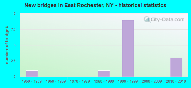
- New bridges - historical statistics
- 11950-1959
- 11980-1989
- 91990-1999
- 32010-2019


- Bridge Condition - Deck
- 20.0%Very good
- 60.0%Good
- 20.0%Satisfactory

- Bridge Condition - Superstructure
- 16.7%Excellent
- 66.7%Very good
- 16.7%Satisfactory

- Bridge Condition - Substructure
- 16.7%Excellent
- 66.7%Very good
- 16.7%Good
Find on map >> Show street view
Structure Number: 1022111, Location: 490I WB JCT RT 31F PITFRD (Lat: 43.110711, Lng: -77.506833), Route carried "on" structure: Interstate 490, Year Built: 1994, Status: Open, Structure Length: 5.03m (16.50ft), Average Daily Traffic: 36,163 (year 2014), Truck Traffic: 6%, Design Load: HS 25 or greater, Features Intersected: RTE 31F
Minimum Vertical Clearance: 30+ m (98+ ft), Kilometerpoint: 45.454, Lanes on structure: 3, Lanes under structure: 5, Base Highway Network: Yes, Owner: State Highway Agency, Approaching Roadway Width: 16.5m (54.1ft), Skew: 3 degrees, Material/Design: Steel, Design/Construction: Stringer/Multi-beam, Number Of Spans In Main Unit: 1, Length of Maximum Span: 48.4m (158.8ft), Curb-To-Curb Width: 16.7m (54.8ft), Out-to-Out Width: 17.4m (57.1ft)
Condition: Deck: Good, Superstructure: Very good, Substructure: Very good, Operating Rating: 74.4 metric tons, Method Used To Determine Operating Rating: Load Factor (LF), Inventory Rating: 44.5 metric tons, Method Used To Determine Inventory Rating: Load Factor (LF), Structural Evaluation: Equal to present desirable criteria, Deck Geometry: Equal to present minimum criteria, Underclear: Somewhat better than minimum adequacy, Approach Roadway Alignment: Equal to present desirable criteria, Length Of Structure Improvement: 5.02m (16.47ft), Designated Inspection Frequency: Every 24 months, Inspection Date: April 2020, Bridge Improvement Cost: $2,518,000, Roadway Improvement Cost: $1,474,000, Total Project Cost: $3,992,000 ( Estimate for 2021), Deck Structure Type: Concrete Cast-file-Place, Wearing Surface/Protective System: Wearing Surface: Integral Concrete, Deck Protection: Epoxy Coated Reinforcing
Find on map >> Show street view
Structure Number: 1022112, Location: I490 EB JCT RT 31F PITFRD (Lat: 43.110825, Lng: -77.507042), Route carried "on" structure: Interstate 490, Year Built: 1994, Status: Open, Structure Length: 5.03m (16.50ft), Average Daily Traffic: 22,521 (year 2019), Truck Traffic: 4%, Average Future Daily Traffic: 31,320 (year 2040), Design Load: HS 25 or greater, Features Intersected: RTE 31F
Minimum Vertical Clearance: 30+ m (98+ ft), Kilometerpoint: 45.454, Lanes on structure: 4, Lanes under structure: 5, Base Highway Network: Yes, Owner: State Highway Agency, Approaching Roadway Width: 20.4m (66.9ft), Skew: 3 degrees, Material/Design: Steel, Design/Construction: Stringer/Multi-beam, Number Of Spans In Main Unit: 1, Length of Maximum Span: 48.4m (158.8ft), Curb-To-Curb Width: 20.3m (66.6ft), Out-to-Out Width: 21.1m (69.2ft)
Condition: Deck: Good, Superstructure: Very good, Substructure: Very good, Operating Rating: 70.8 metric tons, Method Used To Determine Operating Rating: Load Factor (LF), Inventory Rating: 42.6 metric tons, Method Used To Determine Inventory Rating: Load Factor (LF), Structural Evaluation: Equal to present desirable criteria, Deck Geometry: Equal to present minimum criteria, Underclear: Somewhat better than minimum adequacy, Approach Roadway Alignment: Equal to present desirable criteria, Length Of Structure Improvement: 5.02m (16.47ft), Designated Inspection Frequency: Every 24 months, Inspection Date: April 2020, Bridge Improvement Cost: $3,046,000, Roadway Improvement Cost: $1,784,000, Total Project Cost: $4,829,000 ( Estimate for 2021), Deck Structure Type: Concrete Cast-file-Place, Wearing Surface/Protective System: Wearing Surface: Integral Concrete, Deck Protection: Epoxy Coated Reinforcing
Find on map >> Show street view
Structure Number: 104345, Location: JCT RTS 153 + I490 (Lat: 43.103189, Lng: -77.504808), Route carried "on" structure: State highway 153, Year Built: 1994, Status: Open, Structure Length: 6.28m (20.60ft), Average Daily Traffic: 9,302 (year 2020), Truck Traffic: 3%, Average Future Daily Traffic: 11,300 (year 2040), Design Load: HS 25 or greater, Features Intersected: 490I490I43023038, RTE I4
Minimum Vertical Clearance: 30+ m (98+ ft), Kilometerpoint: 1.142, Lanes on structure: 2, Lanes under structure: 6, Base Highway Network: Yes, Owner: State Highway Agency, Approaching Roadway Width: 9.8m (32.2ft), Skew: 2 degrees, Material/Design: Steel continuous, Design/Construction: Stringer/Multi-beam, Number Of Spans In Main Unit: 2, Length of Maximum Span: 30.4m (99.7ft), Curb or Sidewalk Widths: Left: 1.5m (4.9ft), Right: 0.0m, Curb-To-Curb Width: 9.7m (31.8ft), Out-to-Out Width: 11.9m (39.0ft)
Condition: Deck: Satisfactory, Superstructure: Satisfactory, Substructure: Good, Operating Rating: 61.7 metric tons, Method Used To Determine Operating Rating: Load Factor (LF), Inventory Rating: 37.2 metric tons, Method Used To Determine Inventory Rating: Load Factor (LF), Structural Evaluation: Equal to present minimum criteria, Deck Geometry: Meets minimum limits, Underclear: Meets minimum limits, Approach Roadway Alignment: Equal to present desirable criteria, Length Of Structure Improvement: 6.27m (20.57ft), Designated Inspection Frequency: Every 24 months, Inspection Date: June 2020, Bridge Improvement Cost: $1,932,000, Roadway Improvement Cost: $1,131,000, Total Project Cost: $3,063,000 ( Estimate for 2021), Deck Structure Type: Concrete Cast-file-Place, Wearing Surface/Protective System: Wearing Surface: Integral Concrete, Deck Protection: Epoxy Coated Reinforcing
Find on map >> Show street view
Structure Number: 1048929, Location: INT E ROCHESTER & 490I (Lat: 43.116736, Lng: -77.507056), Route carried "on" structure: State highway 940U, Year Built: 1994, Status: Open, Structure Length: 7.47m (24.51ft), Average Daily Traffic: 11,372 (year 2018), Truck Traffic: 3%, Average Future Daily Traffic: 13,814 (year 2040), Design Load: HS 25 or greater, Features Intersected: 490I490I43023028 WB, RTE
Minimum Vertical Clearance: 30+ m (98+ ft), Kilometerpoint: 0.000, Lanes on structure: 2, Lanes under structure: 8, Base Highway Network: Yes, Owner: State Highway Agency, Approaching Roadway Width: 16.2m (53.1ft), Skew: 21 degrees, Material/Design: Steel continuous, Design/Construction: Stringer/Multi-beam, Number Of Spans In Main Unit: 2, Length of Maximum Span: 41.8m (137.1ft), Curb-To-Curb Width: 15.2m (49.9ft), Out-to-Out Width: 16.8m (55.1ft)
Condition: Deck: Good, Superstructure: Very good, Substructure: Very good, Operating Rating: 89.8 metric tons, Method Used To Determine Operating Rating: Load Factor (LF), Inventory Rating: 50.8 metric tons, Method Used To Determine Inventory Rating: Load Factor (LF), Structural Evaluation: Equal to present desirable criteria, Deck Geometry: Superior to present desirable criteria, Underclear: High priority of corrective action, Approach Roadway Alignment: Equal to present desirable criteria, Length Of Structure Improvement: 7.46m (24.48ft), Designated Inspection Frequency: Every 24 months, Inspection Date: June 2020, Bridge Improvement Cost: $3,170,000, Roadway Improvement Cost: $1,856,000, Total Project Cost: $5,026,000 ( Estimate for 2021), Deck Structure Type: Concrete Cast-file-Place, Wearing Surface/Protective System: Wearing Surface: Integral Concrete, Deck Protection: Epoxy Coated Reinforcing
Find on map >> Show street view
Structure Number: 1048959, Location: 0.5MI NW JCT I490 EAST+31 (Lat: 43.084331, Lng: -77.491931), Route carried "on" structure: Interstate 490, Year Built: 2017, Status: Open, Structure Length: 3.02m (9.91ft), Average Daily Traffic: 45,042 (year 2019), Truck Traffic: 4%, Average Future Daily Traffic: 62,639 (year 2040), Design Load: HL 93, Features Intersected: MARSH ROAD
Minimum Vertical Clearance: 30+ m (98+ ft), Kilometerpoint: 48.769, Lanes on structure: 4, Lanes under structure: 2, Base Highway Network: Yes, Owner: State Highway Agency, Approaching Roadway Width: 26.8m (87.9ft), Skew: 20 degrees, Material/Design: Steel, Design/Construction: Stringer/Multi-beam, Number Of Spans In Main Unit: 1, Length of Maximum Span: 29.6m (97.1ft), Curb-To-Curb Width: 26.8m (87.9ft), Out-to-Out Width: 28.3m (92.8ft)
Condition: Deck: Very good, Superstructure: Very good, Substructure: Very good, Operating Rating: 84.4 metric tons, Method Used To Determine Operating Rating: Load Factor (LF), Inventory Rating: 50.8 metric tons, Method Used To Determine Inventory Rating: Load Factor (LF), Structural Evaluation: Equal to present desirable criteria, Deck Geometry: Superior to present desirable criteria, Underclear: Meets minimum limits, Approach Roadway Alignment: Equal to present minimum criteria, Length Of Structure Improvement: 3.01m (9.88ft), Designated Inspection Frequency: Every 24 months, Inspection Date: October 2021, Bridge Improvement Cost: $2,083,000, Roadway Improvement Cost: $1,220,000, Total Project Cost: $3,302,000 ( Estimate for 2021), Deck Structure Type: Concrete Cast-file-Place, Wearing Surface/Protective System: Wearing Surface: Integral Concrete, Deck Protection: Epoxy Coated Reinforcing
Find on map >> Show street view
Structure Number: 225792, Location: EAST ROCHESTER (Lat: 43.112767, Lng: -77.472228), Route carried "on" structure: Other road , Year Built: 2019, Status: Open, Structure Length: 2.10m (6.89ft), Average Daily Traffic: 254 (year 2020), Truck Traffic: 14%, Average Future Daily Traffic: 356 (year 2040), Features Intersected: IRONDEQUOIT CREEK, Facility Carried by Structure: ONTARIO STREET
Minimum Vertical Clearance: 30+ m (98+ ft), Kilometerpoint: 0.628, Lanes on structure: 2, Owner: Town or Township Highway Agency, Approaching Roadway Width: 6.7m (22.0ft), Skew: 1 degrees, Material/Design: Concrete, Design/Construction: Tee Beam, Number Of Spans In Main Unit: 1, Length of Maximum Span: 20.4m (66.9ft), Curb-To-Curb Width: 7.3m (24.0ft), Out-to-Out Width: 8.5m (27.9ft)
Condition: Superstructure: Excellent, Substructure: Excellent, Channel: Good, Inventory Rating: 57.2 metric tons, Method Used To Determine Inventory Rating: Load Factor (LF), Structural Evaluation: Superior to present desirable criteria, Deck Geometry: Somewhat better than minimum adequacy, Waterway Adequacy: Meets minimum limits, Approach Roadway Alignment: Equal to present desirable criteria, Length Of Structure Improvement: 2.10m (6.89ft), Designated Inspection Frequency: Every 24 months, Inspection Date: November 2021, Bridge Improvement Cost: $601,000, Roadway Improvement Cost: $352,000, Total Project Cost: $953,000 ( Estimate for 2021), Wearing Surface/Protective System: Wearing Surface: Bituminous
Find on map >> Show street view
Structure Number: 1022111, Location: 490I WB JCT RT 31F PITFRD (Lat: 43.110711, Lng: -77.506833), Route carried "under" structure: Alternate State highway 31F, Year Built: 1994, Structure Length: 0. m, Average Daily Traffic: 19,889 (year 1999), Features Intersected: RTE 31F, Facility Carried by Structure: RTE I490
Minimum Vertical Clearance: 4.83m (15.85ft), Kilometerpoint: 1.046, Lanes on structure: 3, Lanes under structure: 5, Material/Design: Steel, Design/Construction: Stringer/Multi-beam, Length of Maximum Span: 48.4m (158.8ft)
Find on map >> Show street view
Structure Number: 1022112, Location: I490 EB JCT RT 31F PITFRD (Lat: 43.110825, Lng: -77.507042), Route carried "under" structure: Alternate State highway 31F, Year Built: 1994, Structure Length: 0. m, Average Daily Traffic: 19,889 (year 1999), Features Intersected: RTE 31F, Facility Carried by Structure: RTE I490
Minimum Vertical Clearance: 4.80m (15.75ft), Kilometerpoint: 1.046, Lanes on structure: 4, Lanes under structure: 5, Material/Design: Steel, Design/Construction: Stringer/Multi-beam, Length of Maximum Span: 48.4m (158.8ft)
Find on map >> Show street view
Structure Number: 104345, Location: JCT RTS 153 + I490 (Lat: 43.103189, Lng: -77.504808), Route carried "under" structure: Interstate 490, Year Built: 1994, Structure Length: 0. m, Average Daily Traffic: 69,500 (year 2014), Features Intersected: 490I490I43023038, RTE I4, Facility Carried by Structure: RTE 153
Minimum Vertical Clearance: 4.67m (15.32ft), Kilometerpoint: 6.082, Lanes on structure: 2, Lanes under structure: 3, Material/Design: Steel continuous, Design/Construction: Stringer/Multi-beam, Length of Maximum Span: 30.4m (99.7ft)
Find on map >> Show street view
Structure Number: 1048929, Location: INT E ROCHESTER & 490I (Lat: 43.116736, Lng: -77.507056), Route carried "under" structure: Interstate 490, Year Built: 1994, Structure Length: 0. m, Average Daily Traffic: 29,200 (year 1970), Features Intersected: 490I490I43023028 WB, RTE, Facility Carried by Structure: RTE 940U
Minimum Vertical Clearance: 4.80m (15.75ft), Kilometerpoint: 4.489, Lanes on structure: 2, Lanes under structure: 4, Material/Design: Steel continuous, Design/Construction: Stringer/Multi-beam, Length of Maximum Span: 41.8m (137.1ft)
Find on map >> Show street view
Structure Number: 1048929, Location: INT E ROCHESTER & 490I (Lat: 43.116736, Lng: -77.507056), Route carried "under" structure: Interstate , Year Built: 1994, Structure Length: 0. m, Average Daily Traffic: 100 (year 2021), Features Intersected: 490I490I43023028 WB, RTE, Facility Carried by Structure: RTE 940U
Minimum Vertical Clearance: 4.80m (15.75ft), Kilometerpoint: 0.000, Lanes on structure: 2, Lanes under structure: 1, Material/Design: Steel continuous, Design/Construction: Stringer/Multi-beam, Length of Maximum Span: 41.8m (137.1ft)
Find on map >> Show street view
Structure Number: 1048959, Location: 0.5MI NW JCT I490 EAST+31 (Lat: 43.084331, Lng: -77.491931), Route carried "under" structure: County highway , Year Built: 2017, Structure Length: 0. m, Average Daily Traffic: 9,228 (year 2019), Truck Traffic: 3%, Features Intersected: MARSH ROAD, Facility Carried by Structure: RTE I490
Minimum Vertical Clearance: 4.37m (14.34ft), Kilometerpoint: 3.363, Lanes on structure: 4, Lanes under structure: 2, Material/Design: Steel, Design/Construction: Stringer/Multi-beam, Length of Maximum Span: 29.6m (97.1ft)
Find on map >> Show street view
Structure Number: 704346, Location: 0.8MI N JCT RTS 253+31F (Lat: 43.115953, Lng: -77.489144), Route carried "under" structure: State highway 153, Year Built: 1955, Structure Length: 0. m, Average Daily Traffic: 7,700 (year 1970), Features Intersected: RTE 153, Facility Carried by Structure: CSX TRANSPRTATION
Minimum Vertical Clearance: 4.37m (14.34ft), Kilometerpoint: 26.822, Lanes under structure: 4, Material/Design: Steel, Design/Construction: Stringer/Multi-beam, Length of Maximum Span: 18.2m (59.7ft)
Find on map >> Show street view
Structure Number: 770209, Location: IN VIL OF EAST ROCHESTER (Lat: 43.113156, Lng: -77.479025), Route carried "under" structure: County highway , Year Built: 1982, Structure Length: 0. m, Average Daily Traffic: 2,531 (year 1980), Features Intersected: LINCOLN AVE -CR36, Facility Carried by Structure: CSX TRANSPRTATION
Minimum Vertical Clearance: 4.41m (14.47ft), Kilometerpoint: 0.000, Lanes under structure: 4, Material/Design: Steel, Design/Construction: Stringer/Multi-beam, Length of Maximum Span: 21.6m (70.9ft)