Bridge Statistics for Cromwell, Connecticut (CT)
Condition, Traffic, Stress, Structural Evaluation, Project Costs
- National Bridge Inventory (NBI) Statistics
- 51Number of bridges
- 482ft / 147mTotal length
- $13,700,000Total costs
- 1,506,032Total average daily traffic
- 131,169Total average daily truck traffic
- National Bridge Inventory (NBI) Registered Bridges for Cromwell
- No street view available for this location
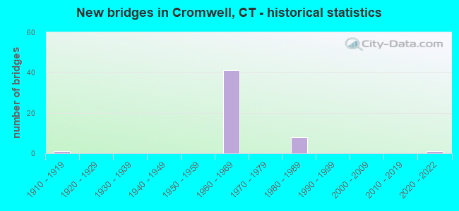
- New bridges - historical statistics
- 11910-1919
- 411960-1969
- 81980-1989
- 12020-2022

- Reconstructed bridges - Historical Statistics
- 11950-1959
- 01960-1969
- 01970-1979
- 31980-1989
- 11990-1999
- 12000-2009
- 12010-2019


- Bridge Condition - Deck
- 34.6%Good
- 57.7%Satisfactory
- 7.7%Fair

- Bridge Condition - Superstructure
- 22.2%Good
- 51.9%Satisfactory
- 25.9%Fair

- Bridge Condition - Substructure
- 3.7%Very good
- 33.3%Good
- 59.3%Satisfactory
- 3.7%Fair

- Bridge Condition - Channel
- 75.0%Good
- 25.0%Satisfactory
Find on map >> Show street view
Structure Number: 315, Location: STAMFORD DARIEN TOWN LINE (Lat: 41.060908, Lng: -73.507333), Route carried "on" structure: US 1, Year Built: 1913, Year Reconstructed: 1957, Status: Open, Structure Length: 1.46m (4.79ft), Average Daily Traffic: 10,500 (year 2015), Truck Traffic: 6%, Average Future Daily Traffic: 15,602 (year 2035), Features Intersected: NOROTON RIVER
Minimum Vertical Clearance: 30+ m (98+ ft), Kilometerpoint: 14.436, Lanes on structure: 4, Base Highway Network: Yes, Owner: State Highway Agency, Approaching Roadway Width: 21.3m (69.9ft), Material/Design: Prestressed concrete, Design/Construction: Slab, Number Of Spans In Main Unit: 2, Length of Maximum Span: 6.1m (20.0ft), Curb or Sidewalk Widths: Left: 0.0m, Right: 0.7m (2.3ft), Curb-To-Curb Width: 21.3m (69.9ft), Out-to-Out Width: 24.2m (79.4ft)
Condition: Deck: Satisfactory, Superstructure: Fair, Substructure: Fair, Channel: Satisfactory, Operating Rating: 68.0 metric tons, Method Used To Determine Operating Rating: Field evaluation and documented engineering judgment, Inventory Rating: 32.7 metric tons, Method Used To Determine Inventory Rating: Field evaluation and documented engineering judgment, Structural Evaluation: Somewhat better than minimum adequacy, Deck Geometry: Superior to present desirable criteria, Waterway Adequacy: Superior to present desirable criteria, Approach Roadway Alignment: Equal to present minimum criteria, Designated Inspection Frequency: Every 24 months, Underwater Inspection Frequency: Every 24 months, Inspection Date: April 2018, Underwater Inspection Date: April 2018, Total Project Cost: $11,000,000
Find on map >> Show street view
Structure Number: 3079, Location: I-91 OVER ROUTE 372 (Lat: 41.604186, Lng: -72.704589), Route carried "on" structure: Interstate 91, Year Built: 1965, Status: Open, Structure Length: 2.59m (8.50ft), Average Daily Traffic: 57,800 (year 2015), Truck Traffic: 9%, Average Future Daily Traffic: 85,885 (year 2035), Design Load: HS 20, Features Intersected: ROUTE 372
Minimum Vertical Clearance: 30+ m (98+ ft), Kilometerpoint: 41.408, Lanes on structure: 4, Lanes under structure: 4, Base Highway Network: Yes, Owner: State Highway Agency, Approaching Roadway Width: 18.8m (61.7ft), Material/Design: Steel, Design/Construction: Stringer/Multi-beam, Number Of Spans In Main Unit: 1, Length of Maximum Span: 24.4m (80.1ft), Curb-To-Curb Width: 18.8m (61.7ft), Out-to-Out Width: 20.0m (65.6ft)
Condition: Deck: Satisfactory, Superstructure: Satisfactory, Substructure: Satisfactory, Operating Rating: 98.8 metric tons, Method Used To Determine Operating Rating: Load Factor (LF), Inventory Rating: 59.2 metric tons, Method Used To Determine Inventory Rating: Load Factor (LF), Structural Evaluation: Equal to present minimum criteria, Deck Geometry: Meets minimum limits, Underclear: High priority of corrective action, Approach Roadway Alignment: Equal to present desirable criteria, Designated Inspection Frequency: Every 24 months, Inspection Date: January 2021, Deck Structure Type: Concrete Cast-file-Place, Wearing Surface/Protective System: Wearing Surface: Bituminous, Membrane: Built-up
Find on map >> Show street view
Structure Number: 308, Location: 1.55 MI SOUTH OF ROUTE 9 (Lat: 41.603972, Lng: -72.703961), Route carried "on" structure: Interstate 91, Year Built: 1965, Status: Open, Structure Length: 2.58m (8.46ft), Average Daily Traffic: 57,800 (year 2015), Truck Traffic: 10%, Average Future Daily Traffic: 85,885 (year 2035), Design Load: HS 20, Features Intersected: ROUTE 372
Minimum Vertical Clearance: 30+ m (98+ ft), Kilometerpoint: 41.408, Lanes on structure: 4, Lanes under structure: 5, Base Highway Network: Yes, Owner: State Highway Agency, Approaching Roadway Width: 18.9m (62.0ft), Material/Design: Steel, Design/Construction: Stringer/Multi-beam, Number Of Spans In Main Unit: 1, Length of Maximum Span: 24.4m (80.1ft), Curb-To-Curb Width: 18.9m (62.0ft), Out-to-Out Width: 20.0m (65.6ft)
Condition: Deck: Satisfactory, Superstructure: Satisfactory, Substructure: Satisfactory, Operating Rating: 98.8 metric tons, Method Used To Determine Operating Rating: Load Factor (LF), Inventory Rating: 59.2 metric tons, Method Used To Determine Inventory Rating: Load Factor (LF), Structural Evaluation: Equal to present minimum criteria, Deck Geometry: Meets minimum limits, Underclear: High priority of corrective action, Approach Roadway Alignment: Equal to present desirable criteria, Designated Inspection Frequency: Every 24 months, Inspection Date: January 2021, Deck Structure Type: Concrete Cast-file-Place, Wearing Surface/Protective System: Wearing Surface: Bituminous
Find on map >> Show street view
Structure Number: 3082, Location: 0.68 MI NORTH OF RTE 372 (Lat: 41.611758, Lng: -72.699567), Route carried "on" structure: Interstate 91, Year Built: 1965, Year Reconstructed: 1986, Status: Open, Structure Length: 4.46m (14.63ft), Average Daily Traffic: 62,050 (year 2015), Truck Traffic: 9%, Average Future Daily Traffic: 92,200 (year 2035), Design Load: HS 20, Features Intersected: NORTH ROAD
Minimum Vertical Clearance: 30+ m (98+ ft), Kilometerpoint: 42.342, Lanes on structure: 3, Lanes under structure: 2, Base Highway Network: Yes, Owner: State Highway Agency, Approaching Roadway Width: 15.2m (49.9ft), Skew: 3 degrees, Material/Design: Steel continuous, Design/Construction: Stringer/Multi-beam, Number Of Spans In Main Unit: 3, Length of Maximum Span: 19.8m (65.0ft), Curb-To-Curb Width: 15.9m (52.2ft), Out-to-Out Width: 16.9m (55.4ft)
Condition: Deck: Fair, Superstructure: Satisfactory, Substructure: Satisfactory, Operating Rating: 68.3 metric tons, Method Used To Determine Operating Rating: Load Factor (LF), Inventory Rating: 41.0 metric tons, Method Used To Determine Inventory Rating: Load Factor (LF), Structural Evaluation: Equal to present minimum criteria, Deck Geometry: Somewhat better than minimum adequacy, Underclear: Somewhat better than minimum adequacy, Approach Roadway Alignment: Equal to present desirable criteria, Designated Inspection Frequency: Every 24 months, Inspection Date: December 2020, Deck Structure Type: Concrete Cast-file-Place, Wearing Surface/Protective System: Wearing Surface: Bituminous, Membrane: Built-up
Find on map >> Show street view
Structure Number: 3145, Location: .69 MI SO OF RTE 9 O-PASS (Lat: 41.615239, Lng: -72.696828), Route carried "on" structure: Interstate 91, Year Built: 1965, Status: Open, Structure Length: 3.69m (12.11ft), Average Daily Traffic: 62,050 (year 2015), Truck Traffic: 9%, Average Future Daily Traffic: 92,200 (year 2035), Design Load: HS 20, Features Intersected: EVERGREEN ROAD
Minimum Vertical Clearance: 30+ m (98+ ft), Kilometerpoint: 42.792, Lanes on structure: 3, Lanes under structure: 2, Base Highway Network: Yes, Owner: State Highway Agency, Approaching Roadway Width: 15.8m (51.8ft), Material/Design: Steel, Design/Construction: Stringer/Multi-beam, Number Of Spans In Main Unit: 3, Length of Maximum Span: 16.1m (52.8ft), Curb-To-Curb Width: 15.8m (51.8ft), Out-to-Out Width: 16.9m (55.4ft)
Condition: Deck: Fair, Superstructure: Satisfactory, Substructure: Satisfactory, Operating Rating: 46.0 metric tons, Method Used To Determine Operating Rating: Load and Resistance Factor Rating (LRFR) rating reported by rating factor(RF) method using HL-93 loadings, Inventory Rating: 35.6 metric tons, Method Used To Determine Inventory Rating: Load and Resistance Factor Rating (LRFR) rating reported by rating factor(RF) method using HL-93 loadings, Structural Evaluation: Equal to present minimum criteria, Deck Geometry: Somewhat better than minimum adequacy, Underclear: Better than present minimum criteria, Approach Roadway Alignment: Equal to present desirable criteria, Designated Inspection Frequency: Every 24 months, Inspection Date: June 2020, Deck Structure Type: Concrete Cast-file-Place, Wearing Surface/Protective System: Wearing Surface: Bituminous, Membrane: Preformed Fabric
Find on map >> Show street view
Structure Number: 3146, Location: .69 MI SO OF RTE 9 O-PASS (Lat: 41.615603, Lng: -72.697489), Route carried "on" structure: Interstate 91, Year Built: 1965, Status: Open, Structure Length: 3.89m (12.76ft), Average Daily Traffic: 62,050 (year 2015), Truck Traffic: 9%, Average Future Daily Traffic: 92,200 (year 2035), Design Load: HS 20, Features Intersected: EVERGREEN ROAD
Minimum Vertical Clearance: 30+ m (98+ ft), Kilometerpoint: 42.809, Lanes on structure: 3, Lanes under structure: 2, Base Highway Network: Yes, Owner: State Highway Agency, Approaching Roadway Width: 15.5m (50.9ft), Material/Design: Steel, Design/Construction: Stringer/Multi-beam, Number Of Spans In Main Unit: 3, Length of Maximum Span: 17.4m (57.1ft), Curb-To-Curb Width: 15.5m (50.9ft), Out-to-Out Width: 16.9m (55.4ft)
Condition: Deck: Satisfactory, Superstructure: Satisfactory, Substructure: Satisfactory, Operating Rating: 42.1 metric tons, Method Used To Determine Operating Rating: Load and Resistance Factor Rating (LRFR) rating reported by rating factor(RF) method using HL-93 loadings, Inventory Rating: 32.4 metric tons, Method Used To Determine Inventory Rating: Load and Resistance Factor Rating (LRFR) rating reported by rating factor(RF) method using HL-93 loadings, Structural Evaluation: Equal to present minimum criteria, Deck Geometry: Somewhat better than minimum adequacy, Underclear: Equal to present minimum criteria, Approach Roadway Alignment: Equal to present desirable criteria, Designated Inspection Frequency: Every 24 months, Inspection Date: June 2020, Deck Structure Type: Concrete Cast-file-Place, Wearing Surface/Protective System: Wearing Surface: Bituminous, Membrane: Preformed Fabric
Find on map >> Show street view
Structure Number: 3148, Location: 1.5 MI N ROUTE 372 (Lat: 41.624325, Lng: -72.693942), Route carried "on" structure: Interstate 91, Year Built: 1965, Status: Open, Structure Length: 7.22m (23.69ft), Average Daily Traffic: 54,200 (year 2015), Truck Traffic: 9%, Average Future Daily Traffic: 80,536 (year 2035), Design Load: HS 20, Features Intersected: ROUTE 9 SB & I-91 TR 818
Minimum Vertical Clearance: 30+ m (98+ ft), Kilometerpoint: 43.790, Lanes on structure: 4, Lanes under structure: 2, Base Highway Network: Yes, Owner: State Highway Agency, Approaching Roadway Width: 15.9m (52.2ft), Material/Design: Steel, Design/Construction: Stringer/Multi-beam, Number Of Spans In Main Unit: 3, Length of Maximum Span: 32.3m (106.0ft), Curb-To-Curb Width: 19.5m (64.0ft), Out-to-Out Width: 20.6m (67.6ft)
Condition: Deck: Satisfactory, Superstructure: Satisfactory, Substructure: Satisfactory, Operating Rating: 34.0 metric tons, Method Used To Determine Operating Rating: Load and Resistance Factor Rating (LRFR) rating reported by rating factor(RF) method using HL-93 loadings, Inventory Rating: 26.2 metric tons, Method Used To Determine Inventory Rating: Load and Resistance Factor Rating (LRFR) rating reported by rating factor(RF) method using HL-93 loadings, Structural Evaluation: Equal to present minimum criteria, Deck Geometry: Somewhat better than minimum adequacy, Underclear: Equal to present minimum criteria, Approach Roadway Alignment: Equal to present desirable criteria, Designated Inspection Frequency: Every 24 months, Critical Feature Inspection Frequency: Every 24 months, Inspection Date: October 2020, Critical Feature Inspection Date: October 2020, Deck Structure Type: Concrete Cast-file-Place, Wearing Surface/Protective System: Wearing Surface: Bituminous, Membrane: Built-up
Find on map >> Show street view
Structure Number: 3149, Location: 1.6 MI N OF ROUTE 372 (Lat: 41.623914, Lng: -72.690606), Route carried "on" structure: State highway 9, Year Built: 1965, Status: Open, Structure Length: 5.21m (17.09ft), Average Daily Traffic: 18,450 (year 2015), Truck Traffic: 6%, Average Future Daily Traffic: 27,415 (year 2035), Design Load: HS 20, Features Intersected: INTERSTATE-91 NORTHBOUND
Minimum Vertical Clearance: 30+ m (98+ ft), Kilometerpoint: 47.186, Lanes on structure: 3, Lanes under structure: 4, Base Highway Network: Yes, Owner: State Highway Agency, Approaching Roadway Width: 16.2m (53.1ft), Skew: 11 degrees, Material/Design: Steel, Design/Construction: Stringer/Multi-beam, Number Of Spans In Main Unit: 3, Length of Maximum Span: 22.6m (74.1ft), Curb-To-Curb Width: 16.1m (52.8ft), Out-to-Out Width: 17.3m (56.8ft)
Condition: Deck: Satisfactory, Superstructure: Satisfactory, Substructure: Satisfactory, Operating Rating: 69.0 metric tons, Method Used To Determine Operating Rating: Load and Resistance Factor Rating (LRFR) rating reported by rating factor(RF) method using HL-93 loadings, Inventory Rating: 53.1 metric tons, Method Used To Determine Inventory Rating: Load and Resistance Factor Rating (LRFR) rating reported by rating factor(RF) method using HL-93 loadings, Structural Evaluation: Equal to present minimum criteria, Deck Geometry: Equal to present minimum criteria, Underclear: Meets minimum limits, Approach Roadway Alignment: Equal to present desirable criteria, Designated Inspection Frequency: Every 24 months, Inspection Date: October 2020, Deck Structure Type: Concrete Cast-file-Place, Wearing Surface/Protective System: Wearing Surface: Bituminous, Membrane: Built-up
Find on map >> Show street view
Structure Number: 315, Location: APROX 2 MI.N MIDDLETOWNTL (Lat: 41.626561, Lng: -72.692775), Route carried "on" structure: Interstate 91, Year Built: 1965, Year Reconstructed: 1996, Status: Open, Structure Length: 5.04m (16.54ft), Average Daily Traffic: 51,400 (year 2015), Truck Traffic: 14%, Average Future Daily Traffic: 76,375 (year 2035), Design Load: HS 20, Features Intersected: ROUTE 9 NORTHBOUND
Minimum Vertical Clearance: 30+ m (98+ ft), Kilometerpoint: 44.080, Lanes on structure: 3, Lanes under structure: 2, Base Highway Network: Yes, Owner: State Highway Agency, Approaching Roadway Width: 15.9m (52.2ft), Skew: 2 degrees, Material/Design: Steel, Design/Construction: Stringer/Multi-beam, Number Of Spans In Main Unit: 3, Length of Maximum Span: 17.1m (56.1ft), Curb-To-Curb Width: 15.9m (52.2ft), Out-to-Out Width: 16.9m (55.4ft)
Condition: Deck: Satisfactory, Superstructure: Satisfactory, Substructure: Good, Operating Rating: 48.9 metric tons, Method Used To Determine Operating Rating: Load and Resistance Factor Rating (LRFR) rating reported by rating factor(RF) method using HL-93 loadings, Inventory Rating: 37.6 metric tons, Method Used To Determine Inventory Rating: Load and Resistance Factor Rating (LRFR) rating reported by rating factor(RF) method using HL-93 loadings, Structural Evaluation: Equal to present minimum criteria, Deck Geometry: Somewhat better than minimum adequacy, Underclear: Somewhat better than minimum adequacy, Approach Roadway Alignment: Equal to present desirable criteria, Designated Inspection Frequency: Every 24 months, Inspection Date: July 2021, Deck Structure Type: Concrete Cast-file-Place, Wearing Surface/Protective System: Wearing Surface: Bituminous, Membrane: Preformed Fabric
Find on map >> Show street view
Structure Number: 3151, Location: 1.7 N OF ROUTE 372 (Lat: 41.625792, Lng: -72.689089), Route carried "on" structure: Ramp Interstate 91, Year Built: 1965, Year Reconstructed: 1993, Status: Open, Structure Length: 7.83m (25.69ft), Average Daily Traffic: 16,735 (year 2017), Truck Traffic: 9%, Average Future Daily Traffic: 24,867 (year 2037), Design Load: HS 20, Features Intersected: I-91 NORTHBOUND
Minimum Vertical Clearance: 5.36m (17.59ft), Kilometerpoint: 0.579, Lanes on structure: 2, Lanes under structure: 4, Owner: State Highway Agency, Approaching Roadway Width: 12.2m (40.0ft), Skew: 4 degrees, Material/Design: Steel continuous, Design/Construction: Stringer/Multi-beam, Number Of Spans In Main Unit: 3, Length of Maximum Span: 36.0m (118.1ft), Curb-To-Curb Width: 12.2m (40.0ft), Out-to-Out Width: 13.3m (43.6ft)
Condition: Deck: Satisfactory, Superstructure: Satisfactory, Substructure: Satisfactory, Operating Rating: 55.8 metric tons, Method Used To Determine Operating Rating: Load Factor (LF), Inventory Rating: 33.5 metric tons, Method Used To Determine Inventory Rating: Load Factor (LF), Structural Evaluation: Equal to present minimum criteria, Deck Geometry: Somewhat better than minimum adequacy, Underclear: Somewhat better than minimum adequacy, Approach Roadway Alignment: Better than present minimum criteria, Designated Inspection Frequency: Every 24 months, Inspection Date: October 2020, Deck Structure Type: Concrete Cast-file-Place, Wearing Surface/Protective System: Wearing Surface: Bituminous, Membrane: Built-up, Deck Protection: Epoxy Coated Reinforcing
Find on map >> Show street view
Structure Number: 3152, Location: 1.9 MI S OF ROUTE 372 (Lat: 41.624361, Lng: -72.693936), Route carried "on" structure: State highway 9, Year Built: 1965, Status: Open, Structure Length: 4.83m (15.85ft), Average Daily Traffic: 25,100 (year 2015), Truck Traffic: 7%, Average Future Daily Traffic: 37,296 (year 2035), Design Load: HS 20, Features Intersected: INTERSTATE-91 NB TR 818
Minimum Vertical Clearance: 5.28m (17.32ft), Kilometerpoint: 47.572, Lanes on structure: 2, Lanes under structure: 1, Base Highway Network: Yes, Owner: State Highway Agency, Approaching Roadway Width: 15.9m (52.2ft), Skew: 4 degrees, Material/Design: Steel, Design/Construction: Stringer/Multi-beam, Number Of Spans In Main Unit: 3, Length of Maximum Span: 17.4m (57.1ft), Curb-To-Curb Width: 15.5m (50.9ft), Out-to-Out Width: 16.9m (55.4ft)
Condition: Deck: Good, Superstructure: Satisfactory, Substructure: Good, Operating Rating: 63.0 metric tons, Method Used To Determine Operating Rating: Load Factor (LF), Inventory Rating: 37.9 metric tons, Method Used To Determine Inventory Rating: Load Factor (LF), Structural Evaluation: Equal to present minimum criteria, Deck Geometry: Somewhat better than minimum adequacy, Underclear: Equal to present minimum criteria, Approach Roadway Alignment: Equal to present desirable criteria, Designated Inspection Frequency: Every 24 months, Inspection Date: October 2020, Deck Structure Type: Concrete Cast-file-Place, Wearing Surface/Protective System: Wearing Surface: Bituminous, Membrane: Built-up
Find on map >> Show street view
Structure Number: 3156, Location: .23 MI SO OF JCT I-91 SB (Lat: 41.625739, Lng: -72.689072), Route carried "on" structure: State highway 9, Year Built: 1965, Status: Open, Structure Length: 9.30m (30.51ft), Average Daily Traffic: 36,700 (year 2015), Truck Traffic: 6%, Average Future Daily Traffic: 54,533 (year 2035), Design Load: HS 20, Features Intersected: I-91 NB & I-91 TR823
Minimum Vertical Clearance: 30+ m (98+ ft), Kilometerpoint: 47.122, Lanes on structure: 3, Lanes under structure: 6, Base Highway Network: Yes, Owner: State Highway Agency, Approaching Roadway Width: 13.1m (43.0ft), Material/Design: Steel continuous, Design/Construction: Stringer/Multi-beam, Number Of Spans In Main Unit: 3, Length of Maximum Span: 35.4m (116.1ft), Curb-To-Curb Width: 13.4m (44.0ft), Out-to-Out Width: 14.5m (47.6ft)
Condition: Deck: Satisfactory, Superstructure: Fair, Substructure: Satisfactory, Operating Rating: 60.5 metric tons, Method Used To Determine Operating Rating: Load Factor (LF), Inventory Rating: 36.3 metric tons, Method Used To Determine Inventory Rating: Load Factor (LF), Structural Evaluation: Somewhat better than minimum adequacy, Deck Geometry: Meets minimum limits, Underclear: Meets minimum limits, Approach Roadway Alignment: Equal to present desirable criteria, Designated Inspection Frequency: Every 24 months, Inspection Date: October 2020, Deck Structure Type: Concrete Cast-file-Place, Wearing Surface/Protective System: Wearing Surface: Bituminous, Membrane: Preformed Fabric
Find on map >> Show street view
Structure Number: 3517, Location: AT END OF RT 99 (Lat: 41.584942, Lng: -72.648278), Route carried "on" structure: State highway 9, Year Built: 1967, Status: Open, Structure Length: 4.15m (13.62ft), Average Daily Traffic: 31,200 (year 2015), Truck Traffic: 6%, Average Future Daily Traffic: 46,360 (year 2035), Design Load: HS 20, Features Intersected: RTE 9 RAMP 043 & SR 901
Minimum Vertical Clearance: 30+ m (98+ ft), Kilometerpoint: 41.038, Lanes on structure: 2, Lanes under structure: 2, Base Highway Network: Yes, Owner: State Highway Agency, Approaching Roadway Width: 11.6m (38.1ft), Skew: 2 degrees, Material/Design: Steel, Design/Construction: Stringer/Multi-beam, Number Of Spans In Main Unit: 3, Length of Maximum Span: 19.8m (65.0ft), Curb-To-Curb Width: 15.9m (52.2ft), Out-to-Out Width: 16.9m (55.4ft)
Condition: Deck: Satisfactory, Superstructure: Fair, Substructure: Satisfactory, Operating Rating: 61.0 metric tons, Method Used To Determine Operating Rating: Load Factor (LF), Inventory Rating: 36.6 metric tons, Method Used To Determine Inventory Rating: Load Factor (LF), Structural Evaluation: Somewhat better than minimum adequacy, Deck Geometry: Superior to present desirable criteria, Underclear: High priority of corrective action, Approach Roadway Alignment: Equal to present desirable criteria, Designated Inspection Frequency: Every 24 months, Inspection Date: May 2021, Deck Structure Type: Concrete Cast-file-Place, Wearing Surface/Protective System: Wearing Surface: Bituminous, Membrane: Built-up
Find on map >> Show street view
Structure Number: 3518, Location: END RT 99 AT RT 9 (Lat: 41.585122, Lng: -72.647975), Route carried "on" structure: State highway 9, Year Built: 1968, Status: Open, Structure Length: 4.33m (14.21ft), Average Daily Traffic: 29,400 (year 2018), Truck Traffic: 6%, Average Future Daily Traffic: 43,685 (year 2038), Design Load: HS 20, Features Intersected: RTE 9 RAMP 043 & SR 901
Minimum Vertical Clearance: 30+ m (98+ ft), Kilometerpoint: 41.054, Lanes on structure: 2, Lanes under structure: 2, Base Highway Network: Yes, Owner: State Highway Agency, Approaching Roadway Width: 11.9m (39.0ft), Skew: 2 degrees, Material/Design: Steel, Design/Construction: Stringer/Multi-beam, Number Of Spans In Main Unit: 3, Length of Maximum Span: 20.3m (66.6ft), Curb-To-Curb Width: 15.9m (52.2ft), Out-to-Out Width: 16.9m (55.4ft)
Condition: Deck: Satisfactory, Superstructure: Fair, Substructure: Satisfactory, Operating Rating: 34.7 metric tons, Method Used To Determine Operating Rating: Load and Resistance Factor Rating (LRFR) rating reported by rating factor(RF) method using HL-93 loadings, Inventory Rating: 26.6 metric tons, Method Used To Determine Inventory Rating: Load and Resistance Factor Rating (LRFR) rating reported by rating factor(RF) method using HL-93 loadings, Structural Evaluation: Somewhat better than minimum adequacy, Deck Geometry: Superior to present desirable criteria, Underclear: Meets minimum limits, Approach Roadway Alignment: Equal to present desirable criteria, Designated Inspection Frequency: Every 24 months, Inspection Date: May 2021, Deck Structure Type: Concrete Cast-file-Place, Wearing Surface/Protective System: Wearing Surface: Bituminous, Membrane: Built-up
Find on map >> Show street view
Structure Number: 3519, Location: .2 MI NORTH OF RT 99 (Lat: 41.587736, Lng: -72.649350), Route carried "on" structure: State highway 9, Year Built: 1967, Status: Open, Structure Length: 7.13m (23.39ft), Average Daily Traffic: 31,300 (year 2015), Truck Traffic: 6%, Average Future Daily Traffic: 46,509 (year 2035), Design Load: HS 20, Features Intersected: P&W RAILROAD
Minimum Vertical Clearance: 30+ m (98+ ft), Kilometerpoint: 41.408, Lanes on structure: 2, Base Highway Network: Yes, Owner: State Highway Agency, Approaching Roadway Width: 11.9m (39.0ft), Skew: 6 degrees, Material/Design: Steel, Design/Construction: Stringer/Multi-beam, Number Of Spans In Main Unit: 3, Length of Maximum Span: 23.8m (78.1ft), Curb-To-Curb Width: 15.9m (52.2ft), Out-to-Out Width: 17.1m (56.1ft)
Condition: Deck: Satisfactory, Superstructure: Satisfactory, Substructure: Satisfactory, Operating Rating: 84.4 metric tons, Method Used To Determine Operating Rating: Load Factor (LF), Inventory Rating: 50.6 metric tons, Method Used To Determine Inventory Rating: Load Factor (LF), Structural Evaluation: Equal to present minimum criteria, Deck Geometry: Superior to present desirable criteria, Underclear: Meets minimum limits, Approach Roadway Alignment: Equal to present desirable criteria, Designated Inspection Frequency: Every 24 months, Inspection Date: May 2020, Deck Structure Type: Concrete Cast-file-Place, Wearing Surface/Protective System: Wearing Surface: Bituminous, Membrane: Built-up
Find on map >> Show street view
Structure Number: 352, Location: NEXT TO SEWAGE TREAT PLNT (Lat: 41.588247, Lng: -72.649328), Route carried "on" structure: State highway 9, Year Built: 1967, Year Reconstructed: 2014, Status: Open, Structure Length: 6.28m (20.60ft), Average Daily Traffic: 31,300 (year 2015), Truck Traffic: 6%, Average Future Daily Traffic: 46,509 (year 2035), Design Load: HS 20, Features Intersected: P&W RAILROAD
Minimum Vertical Clearance: 30+ m (98+ ft), Kilometerpoint: 41.425, Lanes on structure: 2, Base Highway Network: Yes, Owner: State Highway Agency, Approaching Roadway Width: 11.6m (38.1ft), Skew: 6 degrees, Material/Design: Steel, Design/Construction: Stringer/Multi-beam, Number Of Spans In Main Unit: 3, Length of Maximum Span: 21.0m (68.9ft), Curb or Sidewalk Widths: Left: 0.2m (0.7ft), Right: 0.2m (0.7ft), Curb-To-Curb Width: 15.9m (52.2ft), Out-to-Out Width: 16.9m (55.4ft)
Condition: Deck: Satisfactory, Superstructure: Fair, Substructure: Satisfactory, Operating Rating: 79.0 metric tons, Method Used To Determine Operating Rating: Load Factor (LF), Inventory Rating: 47.3 metric tons, Method Used To Determine Inventory Rating: Load Factor (LF), Structural Evaluation: Somewhat better than minimum adequacy, Deck Geometry: Superior to present desirable criteria, Underclear: Meets minimum limits, Approach Roadway Alignment: Equal to present desirable criteria, Designated Inspection Frequency: Every 24 months, Inspection Date: May 2020, Deck Structure Type: Concrete Cast-file-Place, Wearing Surface/Protective System: Wearing Surface: Bituminous, Membrane: Built-up
Find on map >> Show street view
Structure Number: 3521, Location: 1.1 MI NO. OF RT 99 (Lat: 41.591883, Lng: -72.661556), Route carried "on" structure: State highway 9, Year Built: 1968, Status: Open, Structure Length: 0.64m (2.10ft), Average Daily Traffic: 62,500 (year 2015), Truck Traffic: 5%, Average Future Daily Traffic: 92,869 (year 2035), Design Load: HS 20, Features Intersected: GAME AREA ROAD
Minimum Vertical Clearance: 30+ m (98+ ft), Kilometerpoint: 42.632, Lanes on structure: 4, Lanes under structure: 1, Base Highway Network: Yes, Owner: State Highway Agency, Approaching Roadway Width: 23.2m (76.1ft), Skew: 20 degrees, Material/Design: Concrete, Design/Construction: Culvert, Number Of Spans In Main Unit: 1, Length of Maximum Span: 6.4m (21.0ft)
Condition: Culverts: Good, Operating Rating: 72.6 metric tons, Method Used To Determine Operating Rating: Load and Resistance Factor Rating (LRFR) rating reported by rating factor(RF) method using HL-93 loadings, Inventory Rating: 56.1 metric tons, Method Used To Determine Inventory Rating: Load and Resistance Factor Rating (LRFR) rating reported by rating factor(RF) method using HL-93 loadings, Structural Evaluation: Better than present minimum criteria, Underclear: Meets minimum limits, Approach Roadway Alignment: Equal to present desirable criteria, Designated Inspection Frequency: Every 24 months, Inspection Date: October 2021
Find on map >> Show street view
Structure Number: 3522, Location: ROUTE 9 EXIT NO. 19 (Lat: 41.604328, Lng: -72.673936), Route carried "on" structure: State highway 372, Year Built: 1967, Year Reconstructed: 1992, Status: Open, Structure Length: 8.20m (26.90ft), Average Daily Traffic: 18,400 (year 2018), Truck Traffic: 5%, Average Future Daily Traffic: 27,341 (year 2038), Design Load: HS 20, Features Intersected: ROUTE 9
Minimum Vertical Clearance: 30+ m (98+ ft), Kilometerpoint: 21.565, Lanes on structure: 4, Lanes under structure: 4, Owner: State Highway Agency, Approaching Roadway Width: 14.0m (45.9ft), Material/Design: Steel continuous, Design/Construction: Stringer/Multi-beam, Number Of Spans In Main Unit: 3, Length of Maximum Span: 30.8m (101.0ft), Curb or Sidewalk Widths: Left: 0.5m (1.6ft), Right: 0.5m (1.6ft), Curb-To-Curb Width: 14.0m (45.9ft), Out-to-Out Width: 15.7m (51.5ft)
Condition: Deck: Good, Superstructure: Satisfactory, Substructure: Satisfactory, Inventory Rating: 60.8 metric tons, Method Used To Determine Inventory Rating: Load Factor (LF), Structural Evaluation: Equal to present minimum criteria, Deck Geometry: High priority of replacement, Underclear: Somewhat better than minimum adequacy, Approach Roadway Alignment: Equal to present desirable criteria, Designated Inspection Frequency: Every 24 months, Inspection Date: November 2020, Deck Structure Type: Concrete Cast-file-Place, Wearing Surface/Protective System: Wearing Surface: Bituminous, Membrane: Built-up
Find on map >> Show street view
Structure Number: 3523, Location: 2.44 MI SOUTH OF OP I-91 (Lat: 41.608306, Lng: -72.676289), Route carried "on" structure: State highway 3, Year Built: 1967, Year Reconstructed: 2016, Status: Open, Structure Length: 15.85m (52.00ft), Average Daily Traffic: 9,700 (year 2018), Truck Traffic: 5%, Average Future Daily Traffic: 14,413 (year 2038), Design Load: HS 20, Features Intersected: ROUTE 9
Minimum Vertical Clearance: 30+ m (98+ ft), Kilometerpoint: 5.874, Lanes on structure: 3, Lanes under structure: 6, Owner: State Highway Agency, Approaching Roadway Width: 13.1m (43.0ft), Skew: 5 degrees, Material/Design: Steel continuous, Design/Construction: Stringer/Multi-beam, Number Of Spans In Main Unit: 3, Number Of Approach Spans: 2, Length of Maximum Span: 44.9m (147.3ft), Curb or Sidewalk Widths: Left: 1.7m (5.6ft), Right: 0.0m, Curb-To-Curb Width: 13.1m (43.0ft), Out-to-Out Width: 15.7m (51.5ft)
Condition: Deck: Satisfactory, Superstructure: Fair, Substructure: Satisfactory, Operating Rating: 45.4 metric tons, Method Used To Determine Operating Rating: Load and Resistance Factor Rating (LRFR) rating reported by rating factor(RF) method using HL-93 loadings, Inventory Rating: 35.0 metric tons, Method Used To Determine Inventory Rating: Load and Resistance Factor Rating (LRFR) rating reported by rating factor(RF) method using HL-93 loadings, Structural Evaluation: Somewhat better than minimum adequacy, Deck Geometry: Meets minimum limits, Underclear: Equal to present minimum criteria, Approach Roadway Alignment: Equal to present desirable criteria, Designated Inspection Frequency: Every 24 months, Inspection Date: June 2021, Deck Structure Type: Concrete Cast-file-Place, Wearing Surface/Protective System: Wearing Surface: Bituminous, Membrane: Built-up
Find on map >> Show street view
Structure Number: 3524, Location: 1.1 MI S OF JCT ROUTE I91 (Lat: 41.612103, Lng: -72.678581), Route carried "on" structure: City street , Year Built: 1967, Status: Open, Structure Length: 12.37m (40.58ft), Average Daily Traffic: 1,857 (year 2018), Truck Traffic: 4%, Average Future Daily Traffic: 2,759 (year 2038), Design Load: HS 20, Features Intersected: ROUTE 9, Facility Carried by Structure: EVERGREEN ROAD
Minimum Vertical Clearance: 30+ m (98+ ft), Kilometerpoint: 0.933, Lanes on structure: 2, Lanes under structure: 6, Owner: State Highway Agency, Approaching Roadway Width: 11.6m (38.1ft), Skew: 4 degrees, Material/Design: Steel continuous, Design/Construction: Stringer/Multi-beam, Number Of Spans In Main Unit: 5, Length of Maximum Span: 33.2m (108.9ft), Curb or Sidewalk Widths: Left: 0.5m (1.6ft), Right: 0.5m (1.6ft), Curb-To-Curb Width: 11.6m (38.1ft), Out-to-Out Width: 13.3m (43.6ft)
Condition: Deck: Good, Superstructure: Fair, Substructure: Satisfactory, Operating Rating: 56.2 metric tons, Method Used To Determine Operating Rating: Load Factor (LF), Inventory Rating: 33.6 metric tons, Method Used To Determine Inventory Rating: Load Factor (LF), Structural Evaluation: Somewhat better than minimum adequacy, Deck Geometry: Equal to present minimum criteria, Underclear: Meets minimum limits, Approach Roadway Alignment: Equal to present desirable criteria, Designated Inspection Frequency: Every 24 months, Inspection Date: March 2020, Deck Structure Type: Concrete Cast-file-Place, Wearing Surface/Protective System: Wearing Surface: Bituminous, Membrane: Preformed Fabric
Find on map >> Show street view
Structure Number: 3525, Location: 0.9 MILE NORTH OF ROUTE 3 (Lat: 41.620503, Lng: -72.684242), Route carried "on" structure: City street , Year Built: 1967, Status: Open, Structure Length: 3.32m (10.89ft), Average Daily Traffic: 3,400 (year 2018), Truck Traffic: 2%, Average Future Daily Traffic: 5,052 (year 2038), Design Load: HS 20, Features Intersected: ROUTE 9 SB & RAMP, Facility Carried by Structure: COLES ROAD
Minimum Vertical Clearance: 30+ m (98+ ft), Kilometerpoint: 0.000, Lanes on structure: 2, Lanes under structure: 5, Owner: State Highway Agency, Approaching Roadway Width: 12.2m (40.0ft), Material/Design: Steel, Design/Construction: Stringer/Multi-beam, Number Of Spans In Main Unit: 1, Length of Maximum Span: 31.9m (104.7ft), Curb or Sidewalk Widths: Left: 0.5m (1.6ft), Right: 0.5m (1.6ft), Curb-To-Curb Width: 12.2m (40.0ft), Out-to-Out Width: 13.9m (45.6ft)
Condition: Deck: Good, Superstructure: Satisfactory, Substructure: Good, Operating Rating: 66.2 metric tons, Method Used To Determine Operating Rating: Load Factor (LF), Inventory Rating: 39.7 metric tons, Method Used To Determine Inventory Rating: Load Factor (LF), Structural Evaluation: Equal to present minimum criteria, Deck Geometry: Better than present minimum criteria, Underclear: Better than present minimum criteria, Approach Roadway Alignment: Equal to present minimum criteria, Designated Inspection Frequency: Every 24 months, Inspection Date: July 2021, Deck Structure Type: Concrete Cast-file-Place, Wearing Surface/Protective System: Wearing Surface: Bituminous, Membrane: Other
Find on map >> Show street view
Structure Number: 3526, Location: .42 MI SOUTH JCT RTE I91 (Lat: 41.621033, Lng: -72.683578), Route carried "on" structure: City street , Year Built: 1968, Status: Open, Structure Length: 3.33m (10.93ft), Average Daily Traffic: 3,503 (year 2021), Truck Traffic: 2%, Average Future Daily Traffic: 5,205 (year 2041), Design Load: HS 20, Features Intersected: ROUTE 9 NORTHBOUND, Facility Carried by Structure: COLES ROAD
Minimum Vertical Clearance: 30+ m (98+ ft), Kilometerpoint: 0.000, Lanes on structure: 2, Lanes under structure: 4, Owner: State Highway Agency, Approaching Roadway Width: 12.2m (40.0ft), Skew: 1 degrees, Material/Design: Steel, Design/Construction: Stringer/Multi-beam, Number Of Spans In Main Unit: 1, Length of Maximum Span: 32.0m (105.0ft), Curb or Sidewalk Widths: Left: 0.5m (1.6ft), Right: 0.5m (1.6ft), Curb-To-Curb Width: 12.2m (40.0ft), Out-to-Out Width: 13.9m (45.6ft)
Condition: Deck: Good, Superstructure: Satisfactory, Substructure: Good, Operating Rating: 89.0 metric tons, Method Used To Determine Operating Rating: Load Factor (LF), Inventory Rating: 53.3 metric tons, Method Used To Determine Inventory Rating: Load Factor (LF), Structural Evaluation: Equal to present minimum criteria, Deck Geometry: Equal to present minimum criteria, Underclear: Equal to present minimum criteria, Approach Roadway Alignment: Equal to present desirable criteria, Designated Inspection Frequency: Every 24 months, Inspection Date: July 2021, Deck Structure Type: Concrete Cast-file-Place, Wearing Surface/Protective System: Wearing Surface: Bituminous, Membrane: Other
Find on map >> Show street view
Structure Number: 5631, Location: OVERPASS ROUTE 9 SB (Lat: 41.624758, Lng: -72.701122), Route carried "on" structure: City street , Year Built: 1988, Status: Open, Structure Length: 3.80m (12.47ft), Average Daily Traffic: 73 (year 2020), Truck Traffic: 2%, Average Future Daily Traffic: 108 (year 2040), Design Load: HS 20, Features Intersected: ROUTE 9 SOUTHBOUND, Facility Carried by Structure: NORTH ROAD
Minimum Vertical Clearance: 30+ m (98+ ft), Kilometerpoint: 0.032, Lanes on structure: 2, Lanes under structure: 2, Owner: State Highway Agency, Approaching Roadway Width: 9.1m (29.9ft), Material/Design: Steel, Design/Construction: Stringer/Multi-beam, Number Of Spans In Main Unit: 1, Length of Maximum Span: 36.6m (120.1ft), Curb or Sidewalk Widths: Left: 0.0m, Right: 1.7m (5.6ft), Curb-To-Curb Width: 9.1m (29.9ft), Out-to-Out Width: 11.8m (38.7ft)
Condition: Deck: Good, Superstructure: Good, Substructure: Good, Operating Rating: 87.8 metric tons, Method Used To Determine Operating Rating: Load Factor (LF), Inventory Rating: 52.7 metric tons, Method Used To Determine Inventory Rating: Load Factor (LF), Structural Evaluation: Better than present minimum criteria, Deck Geometry: Better than present minimum criteria, Underclear: Somewhat better than minimum adequacy, Approach Roadway Alignment: Equal to present desirable criteria, Designated Inspection Frequency: Every 24 months, Inspection Date: December 2020, Deck Structure Type: Concrete Cast-file-Place, Wearing Surface/Protective System: Wearing Surface: Bituminous, Membrane: Built-up, Deck Protection: Epoxy Coated Reinforcing
Find on map >> Show street view
Structure Number: 5632, Location: OVERPASS ROUTE 9 NB (Lat: 41.625847, Lng: -72.700872), Route carried "on" structure: City street , Year Built: 1988, Status: Open, Structure Length: 4.72m (15.49ft), Average Daily Traffic: 63 (year 2012), Truck Traffic: 2%, Average Future Daily Traffic: 94 (year 2032), Design Load: HS 20, Features Intersected: ROUTE 9 NB & RAMP, Facility Carried by Structure: NORTH ROAD
Minimum Vertical Clearance: 30+ m (98+ ft), Kilometerpoint: 2.237, Lanes on structure: 2, Lanes under structure: 3, Owner: State Highway Agency, Approaching Roadway Width: 9.1m (29.9ft), Skew: 1 degrees, Material/Design: Steel, Design/Construction: Stringer/Multi-beam, Number Of Spans In Main Unit: 1, Length of Maximum Span: 45.7m (149.9ft), Curb or Sidewalk Widths: Left: 0.0m, Right: 1.7m (5.6ft), Curb-To-Curb Width: 9.1m (29.9ft), Out-to-Out Width: 11.8m (38.7ft)
Condition: Deck: Good, Superstructure: Good, Substructure: Good, Operating Rating: 97.2 metric tons, Method Used To Determine Operating Rating: Load Factor (LF), Inventory Rating: 58.3 metric tons, Method Used To Determine Inventory Rating: Load Factor (LF), Structural Evaluation: Better than present minimum criteria, Deck Geometry: Better than present minimum criteria, Underclear: Better than present minimum criteria, Approach Roadway Alignment: Better than present minimum criteria, Designated Inspection Frequency: Every 24 months, Inspection Date: December 2020, Deck Structure Type: Concrete Cast-file-Place, Wearing Surface/Protective System: Wearing Surface: Bituminous, Membrane: Preformed Fabric, Deck Protection: Epoxy Coated Reinforcing
Find on map >> Show street view
Structure Number: 5797, Location: 1.5 MI SOUTH OF ROUTE 72 (Lat: 41.625567, Lng: -72.715467), Route carried "on" structure: State highway 9, Year Built: 1988, Status: Open, Structure Length: 4.49m (14.73ft), Average Daily Traffic: 31,300 (year 2015), Truck Traffic: 6%, Average Future Daily Traffic: 46,509 (year 2035), Design Load: HS 20+Mod, Features Intersected: MATTABESSET RIVER
Minimum Vertical Clearance: 30+ m (98+ ft), Kilometerpoint: 49.375, Lanes on structure: 2, Base Highway Network: Yes, Owner: State Highway Agency, Approaching Roadway Width: 12.2m (40.0ft), Skew: 4 degrees, Material/Design: Steel, Design/Construction: Stringer/Multi-beam, Number Of Spans In Main Unit: 1, Length of Maximum Span: 42.7m (140.1ft), Curb-To-Curb Width: 12.2m (40.0ft), Out-to-Out Width: 13.4m (44.0ft)
Condition: Deck: Good, Superstructure: Good, Substructure: Good, Channel: Good, Operating Rating: 89.8 metric tons, Method Used To Determine Operating Rating: Load Factor (LF), Inventory Rating: 69.8 metric tons, Method Used To Determine Inventory Rating: Load Factor (LF), Structural Evaluation: Better than present minimum criteria, Deck Geometry: Better than present minimum criteria, Waterway Adequacy: Equal to present desirable criteria, Approach Roadway Alignment: Equal to present desirable criteria, Designated Inspection Frequency: Every 24 months, Inspection Date: August 2021, Deck Structure Type: Concrete Cast-file-Place, Wearing Surface/Protective System: Wearing Surface: Bituminous, Membrane: Built-up, Deck Protection: Epoxy Coated Reinforcing
Find on map >> Show street view
Structure Number: 5798, Location: 1.5 MI SOUTH OF ROUTE 72 (Lat: 41.625347, Lng: -72.715667), Route carried "on" structure: State highway 9, Year Built: 1988, Status: Open, Structure Length: 4.54m (14.90ft), Average Daily Traffic: 30,800 (year 2015), Truck Traffic: 6%, Average Future Daily Traffic: 45,766 (year 2035), Design Load: HS 20+Mod, Features Intersected: MATTABESSET RIVER
Minimum Vertical Clearance: 30+ m (98+ ft), Kilometerpoint: 49.391, Lanes on structure: 2, Base Highway Network: Yes, Owner: State Highway Agency, Approaching Roadway Width: 12.2m (40.0ft), Skew: 4 degrees, Material/Design: Steel, Design/Construction: Stringer/Multi-beam, Number Of Spans In Main Unit: 1, Length of Maximum Span: 43.3m (142.1ft), Curb-To-Curb Width: 12.2m (40.0ft), Out-to-Out Width: 13.4m (44.0ft)
Condition: Deck: Good, Superstructure: Good, Substructure: Good, Channel: Good, Operating Rating: 89.8 metric tons, Method Used To Determine Operating Rating: Load Factor (LF), Inventory Rating: 68.0 metric tons, Method Used To Determine Inventory Rating: Load Factor (LF), Structural Evaluation: Better than present minimum criteria, Deck Geometry: Better than present minimum criteria, Waterway Adequacy: Equal to present desirable criteria, Approach Roadway Alignment: Equal to present desirable criteria, Designated Inspection Frequency: Every 24 months, Inspection Date: August 2021, Deck Structure Type: Concrete Cast-file-Place, Wearing Surface/Protective System: Wearing Surface: Bituminous, Membrane: Built-up, Deck Protection: Epoxy Coated Reinforcing
Find on map >> Show street view
Structure Number: 5807, Location: 1.4 MI N OF ROUTE 373 (Lat: 41.621922, Lng: -72.692328), Route carried "on" structure: Ramp Interstate 91, Year Built: 1988, Status: Open, Structure Length: 5.34m (17.52ft), Average Daily Traffic: 9,486 (year 2016), Truck Traffic: 9%, Average Future Daily Traffic: 14,095 (year 2036), Design Load: HS 20, Features Intersected: INTERSTATE-91 NORTHBOUND
Minimum Vertical Clearance: 30+ m (98+ ft), Kilometerpoint: 0.966, Lanes on structure: 1, Lanes under structure: 3, Owner: State Highway Agency, Approaching Roadway Width: 9.8m (32.2ft), Skew: 4 degrees, Material/Design: Steel, Design/Construction: Stringer/Multi-beam, Number Of Spans In Main Unit: 1, Length of Maximum Span: 50.6m (166.0ft), Curb-To-Curb Width: 9.8m (32.2ft), Out-to-Out Width: 10.9m (35.8ft)
Condition: Deck: Satisfactory, Superstructure: Good, Substructure: Good, Operating Rating: 84.6 metric tons, Method Used To Determine Operating Rating: Load and Resistance Factor Rating (LRFR) rating reported by rating factor(RF) method using HL-93 loadings, Inventory Rating: 65.1 metric tons, Method Used To Determine Inventory Rating: Load and Resistance Factor Rating (LRFR) rating reported by rating factor(RF) method using HL-93 loadings, Structural Evaluation: Better than present minimum criteria, Deck Geometry: Superior to present desirable criteria, Underclear: Better than present minimum criteria, Approach Roadway Alignment: Equal to present desirable criteria, Designated Inspection Frequency: Every 24 months, Inspection Date: October 2020, Deck Structure Type: Concrete Cast-file-Place, Wearing Surface/Protective System: Wearing Surface: Bituminous, Membrane: Built-up, Deck Protection: Epoxy Coated Reinforcing
Find on map >> Show street view
Structure Number: 5939, Location: 0.1 MI E OF I-91 (Lat: 41.610608, Lng: -72.696928), Route carried "on" structure: City street , Year Built: 2020, Status: Open, Structure Length: 0.85m (2.79ft), Average Daily Traffic: 575 (year 2020), Truck Traffic: 4%, Average Future Daily Traffic: 854 (year 2040), Design Load: HL 93, Features Intersected: COLES BROOK, Facility Carried by Structure: NORTH ROAD EXTENS.
Minimum Vertical Clearance: 30+ m (98+ ft), Kilometerpoint: 0.209, Lanes on structure: 2, Owner: Town or Township Highway Agency, Approaching Roadway Width: 8.5m (27.9ft), Material/Design: Concrete, Design/Construction: Frame, Number Of Spans In Main Unit: 1, Length of Maximum Span: 8.5m (27.9ft), Curb or Sidewalk Widths: Left: 0.0m, Right: 1.5m (4.9ft)
Condition: Superstructure: Good, Substructure: Very good, Channel: Good, Operating Rating: 97.2 metric tons, Method Used To Determine Operating Rating: Load and Resistance Factor Rating (LRFR) rating reported by rating factor(RF) method using HL-93 loadings, Inventory Rating: 97.2 metric tons, Method Used To Determine Inventory Rating: Load and Resistance Factor Rating (LRFR) rating reported by rating factor(RF) method using HL-93 loadings, Structural Evaluation: Better than present minimum criteria, Waterway Adequacy: Better than present minimum criteria, Approach Roadway Alignment: Equal to present desirable criteria, Designated Inspection Frequency: Every 24 months, Inspection Date: November 2020, Total Project Cost: $2,700,000 ( Estimate for 2017)
Find on map >> Show street view
Structure Number: 3079, Location: I-91 OVER ROUTE 372 (Lat: 41.604186, Lng: -72.704589), Route carried "under" structure: State highway 372, Year Built: 1965, Structure Length: 0. m, Average Daily Traffic: 20,500 (year 2018), Truck Traffic: 6%, Features Intersected: ROUTE 372, Facility Carried by Structure: INTERSTATE-91 SB
Minimum Vertical Clearance: 5.03m (16.50ft), Kilometerpoint: 18.684, Lanes on structure: 4, Lanes under structure: 4, Material/Design: Steel, Design/Construction: Stringer/Multi-beam, Length of Maximum Span: 24.4m (80.1ft)
Find on map >> Show street view
Structure Number: 308, Location: 1.55 MI SOUTH OF ROUTE 9 (Lat: 41.603972, Lng: -72.703961), Route carried "under" structure: State highway 372, Year Built: 1965, Structure Length: 0. m, Average Daily Traffic: 17,500 (year 2018), Truck Traffic: 6%, Features Intersected: ROUTE 372, Facility Carried by Structure: INTERSTATE-91 NB
Minimum Vertical Clearance: 5.28m (17.32ft), Kilometerpoint: 18.749, Lanes on structure: 4, Lanes under structure: 5, Material/Design: Steel, Design/Construction: Stringer/Multi-beam, Length of Maximum Span: 24.4m (80.1ft)
Find on map >> Show street view
Structure Number: 3148, Location: 1.5 MI N ROUTE 372 (Lat: 41.624325, Lng: -72.693942), Route carried "under" structure: State highway 9, Year Built: 1965, Structure Length: 0. m, Average Daily Traffic: 20,700 (year 2015), Truck Traffic: 6%, Features Intersected: ROUTE 9 SB & I-91 TR 818
Minimum Vertical Clearance: 5.28m (17.32ft), Kilometerpoint: 47.604, Lanes on structure: 4, Lanes under structure: 2, Material/Design: Steel, Design/Construction: Stringer/Multi-beam, Length of Maximum Span: 32.3m (106.0ft)
Find on map >> Show street view
Structure Number: 3148, Location: 1.5 MI N ROUTE 372 (Lat: 41.624325, Lng: -72.693942), Route carried "under" structure: Ramp Interstate 91, Year Built: 1965, Structure Length: 0. m, Average Daily Traffic: 18,650 (year 2017), Truck Traffic: 9%, Features Intersected: ROUTE 9 SB & I-91 TR 818
Minimum Vertical Clearance: 5.13m (16.83ft), Kilometerpoint: 0.966, Lanes on structure: 4, Lanes under structure: 1, Material/Design: Steel, Design/Construction: Stringer/Multi-beam, Length of Maximum Span: 32.3m (106.0ft)
Find on map >> Show street view
Structure Number: 3149, Location: 1.6 MI N OF ROUTE 372 (Lat: 41.623914, Lng: -72.690606), Route carried "under" structure: Interstate 91, Year Built: 1965, Structure Length: 0. m, Average Daily Traffic: 60,500 (year 2015), Truck Traffic: 14%, Features Intersected: INTERSTATE-91 NORTHBOUND, Facility Carried by Structure: ROUTE 9 SOUTHBOUND
Minimum Vertical Clearance: 5.11m (16.77ft), Kilometerpoint: 43.903, Lanes on structure: 3, Lanes under structure: 4, Material/Design: Steel, Design/Construction: Stringer/Multi-beam, Length of Maximum Span: 22.6m (74.1ft)
Find on map >> Show street view
Structure Number: 315, Location: APROX 2 MI.N MIDDLETOWNTL (Lat: 41.626561, Lng: -72.692775), Route carried "under" structure: State highway 9, Year Built: 1965, Structure Length: 0. m, Average Daily Traffic: 40,100 (year 2015), Truck Traffic: 6%, Features Intersected: ROUTE 9 NORTHBOUND
Minimum Vertical Clearance: 5.18m (16.99ft), Kilometerpoint: 47.492, Lanes on structure: 3, Lanes under structure: 2, Material/Design: Steel, Design/Construction: Stringer/Multi-beam, Length of Maximum Span: 17.1m (56.1ft)
Find on map >> Show street view
Structure Number: 3151, Location: 1.7 N OF ROUTE 372 (Lat: 41.625792, Lng: -72.689089), Route carried "under" structure: Interstate 91, Year Built: 1965, Structure Length: 0. m, Average Daily Traffic: 60,500 (year 2015), Truck Traffic: 14%, Features Intersected: I-91 NORTHBOUND
Minimum Vertical Clearance: 5.61m (18.41ft), Kilometerpoint: 44.144, Lanes on structure: 2, Lanes under structure: 4, Material/Design: Steel continuous, Design/Construction: Stringer/Multi-beam, Length of Maximum Span: 36.0m (118.1ft)
Find on map >> Show street view
Structure Number: 3152, Location: 1.9 MI S OF ROUTE 372 (Lat: 41.624361, Lng: -72.693936), Route carried "under" structure: Ramp Interstate 91, Year Built: 1965, Structure Length: 0. m, Average Daily Traffic: 5,900 (year 2015), Truck Traffic: 5%, Features Intersected: INTERSTATE-91 NB TR 818, Facility Carried by Structure: ROUTE 9 SOUTHBOUND
Minimum Vertical Clearance: 5.13m (16.83ft), Kilometerpoint: 1.014, Lanes on structure: 2, Lanes under structure: 1, Material/Design: Steel, Design/Construction: Stringer/Multi-beam, Length of Maximum Span: 17.4m (57.1ft)
Find on map >> Show street view
Structure Number: 3156, Location: .23 MI SO OF JCT I-91 SB (Lat: 41.625739, Lng: -72.689072), Route carried "under" structure: Ramp Interstate 91, Year Built: 1965, Structure Length: 0. m, Average Daily Traffic: 14,500 (year 2015), Truck Traffic: 10%, Features Intersected: I-91 NB & I-91 TR823
Minimum Vertical Clearance: 5.36m (17.59ft), Kilometerpoint: 0.000, Lanes on structure: 3, Lanes under structure: 2, Material/Design: Steel continuous, Design/Construction: Stringer/Multi-beam, Length of Maximum Span: 35.4m (116.1ft)
Find on map >> Show street view
Structure Number: 3156, Location: .23 MI SO OF JCT I-91 SB (Lat: 41.625739, Lng: -72.689072), Route carried "under" structure: Interstate 91, Year Built: 1965, Structure Length: 0. m, Average Daily Traffic: 57,250 (year 2015), Truck Traffic: 9%, Features Intersected: I-91 NB & I-91 TR823
Minimum Vertical Clearance: 7.62m (25.00ft), Kilometerpoint: 44.144, Lanes on structure: 3, Lanes under structure: 3, Material/Design: Steel continuous, Design/Construction: Stringer/Multi-beam, Length of Maximum Span: 35.4m (116.1ft)
Find on map >> Show street view
Structure Number: 3517, Location: AT END OF RT 99 (Lat: 41.584942, Lng: -72.648278), Route carried "under" structure: State highway 99, Year Built: 1967, Structure Length: 0. m, Average Daily Traffic: 3,700 (year 2015), Truck Traffic: 6%, Features Intersected: RTE 9 RAMP 043 & SR 901, Facility Carried by Structure: ROUTE 9 SOUTHBOUND
Minimum Vertical Clearance: 4.34m (14.24ft), Kilometerpoint: 0.000, Lanes on structure: 2, Lanes under structure: 1, Material/Design: Steel, Design/Construction: Stringer/Multi-beam, Length of Maximum Span: 19.8m (65.0ft)
Find on map >> Show street view
Structure Number: 3517, Location: AT END OF RT 99 (Lat: 41.584942, Lng: -72.648278), Route carried "under" structure: State highway 901, Year Built: 1967, Structure Length: 0. m, Average Daily Traffic: 70 (year 2018), Truck Traffic: 4%, Features Intersected: RTE 9 RAMP 043 & SR 901, Facility Carried by Structure: ROUTE 9 SOUTHBOUND
Minimum Vertical Clearance: 4.27m (14.01ft), Kilometerpoint: 0.080, Lanes on structure: 2, Lanes under structure: 1, Material/Design: Steel, Design/Construction: Stringer/Multi-beam, Length of Maximum Span: 19.8m (65.0ft)
Find on map >> Show street view
Structure Number: 3518, Location: END RT 99 AT RT 9 (Lat: 41.585122, Lng: -72.647975), Route carried "under" structure: State highway 901, Year Built: 1968, Structure Length: 0. m, Average Daily Traffic: 70 (year 2018), Truck Traffic: 4%, Features Intersected: RTE 9 RAMP 043 & SR 901, Facility Carried by Structure: ROUTE 9 NORTHBOUND
Minimum Vertical Clearance: 4.62m (15.16ft), Kilometerpoint: 0.113, Lanes on structure: 2, Lanes under structure: 1, Material/Design: Steel, Design/Construction: Stringer/Multi-beam, Length of Maximum Span: 20.3m (66.6ft)
Find on map >> Show street view
Structure Number: 3518, Location: END RT 99 AT RT 9 (Lat: 41.585122, Lng: -72.647975), Route carried "under" structure: State highway 901, Year Built: 1968, Structure Length: 0. m, Average Daily Traffic: 3,700 (year 2015), Truck Traffic: 5%, Features Intersected: RTE 9 RAMP 043 & SR 901, Facility Carried by Structure: ROUTE 9 NORTHBOUND
Minimum Vertical Clearance: 4.85m (15.91ft), Lanes on structure: 2, Lanes under structure: 1, Material/Design: Steel, Design/Construction: Stringer/Multi-beam, Length of Maximum Span: 20.3m (66.6ft)
Find on map >> Show street view
Structure Number: 3522, Location: ROUTE 9 EXIT NO. 19 (Lat: 41.604328, Lng: -72.673936), Route carried "under" structure: State highway 9, Year Built: 1967, Structure Length: 0. m, Average Daily Traffic: 52,500 (year 2015), Truck Traffic: 7%, Features Intersected: ROUTE 9, Facility Carried by Structure: ROUTE 372
Minimum Vertical Clearance: 5.44m (17.85ft), Kilometerpoint: 44.434, Lanes on structure: 4, Lanes under structure: 4, Material/Design: Steel continuous, Design/Construction: Stringer/Multi-beam, Length of Maximum Span: 30.8m (101.0ft)
Find on map >> Show street view
Structure Number: 3523, Location: 2.44 MI SOUTH OF OP I-91 (Lat: 41.608306, Lng: -72.676289), Route carried "under" structure: State highway 9, Year Built: 1967, Structure Length: 0. m, Average Daily Traffic: 68,700 (year 2015), Truck Traffic: 6%, Features Intersected: ROUTE 9, Facility Carried by Structure: ROUTE 3
Minimum Vertical Clearance: 5.39m (17.68ft), Kilometerpoint: 44.965, Lanes on structure: 3, Lanes under structure: 6, Material/Design: Steel continuous, Design/Construction: Stringer/Multi-beam, Length of Maximum Span: 44.9m (147.3ft)
Find on map >> Show street view
Structure Number: 3524, Location: 1.1 MI S OF JCT ROUTE I91 (Lat: 41.612103, Lng: -72.678581), Route carried "under" structure: State highway 9, Year Built: 1967, Structure Length: 0. m, Average Daily Traffic: 67,600 (year 2015), Truck Traffic: 6%, Features Intersected: ROUTE 9, Facility Carried by Structure: EVERGREEN ROAD
Minimum Vertical Clearance: 5.26m (17.26ft), Kilometerpoint: 45.351, Lanes on structure: 2, Lanes under structure: 6, Material/Design: Steel continuous, Design/Construction: Stringer/Multi-beam, Length of Maximum Span: 33.2m (108.9ft)
Find on map >> Show street view
Structure Number: 3525, Location: 0.9 MILE NORTH OF ROUTE 3 (Lat: 41.620503, Lng: -72.684242), Route carried "under" structure: Ramp Interstate 91, Year Built: 1967, Structure Length: 0. m, Average Daily Traffic: 3,400 (year 2019), Truck Traffic: 6%, Features Intersected: ROUTE 9 SB & RAMP, Facility Carried by Structure: COLES ROAD
Minimum Vertical Clearance: 5.51m (18.08ft), Kilometerpoint: 46.446, Lanes on structure: 2, Lanes under structure: 1, Material/Design: Steel, Design/Construction: Stringer/Multi-beam, Length of Maximum Span: 31.9m (104.7ft)
Find on map >> Show street view
Structure Number: 3525, Location: 0.9 MILE NORTH OF ROUTE 3 (Lat: 41.620503, Lng: -72.684242), Route carried "under" structure: State highway 9, Year Built: 1967, Structure Length: 0. m, Average Daily Traffic: 34,200 (year 2019), Truck Traffic: 10%, Features Intersected: ROUTE 9 SB & RAMP, Facility Carried by Structure: COLES ROAD
Minimum Vertical Clearance: 5.31m (17.42ft), Kilometerpoint: 46.446, Lanes on structure: 2, Lanes under structure: 4, Material/Design: Steel, Design/Construction: Stringer/Multi-beam, Length of Maximum Span: 31.9m (104.7ft)
Find on map >> Show street view
Structure Number: 3526, Location: .42 MI SOUTH JCT RTE I91 (Lat: 41.621033, Lng: -72.683578), Route carried "under" structure: State highway 9, Year Built: 1968, Structure Length: 0. m, Average Daily Traffic: 34,600 (year 2015), Truck Traffic: 10%, Features Intersected: ROUTE 9 NORTHBOUND, Facility Carried by Structure: COLES ROAD
Minimum Vertical Clearance: 5.21m (17.09ft), Kilometerpoint: 46.462, Lanes on structure: 2, Lanes under structure: 4, Material/Design: Steel, Design/Construction: Stringer/Multi-beam, Length of Maximum Span: 32.0m (105.0ft)
Find on map >> Show street view
Structure Number: 5631, Location: OVERPASS ROUTE 9 SB (Lat: 41.624758, Lng: -72.701122), Route carried "under" structure: State highway 9, Year Built: 1988, Structure Length: 0. m, Average Daily Traffic: 28,550 (year 2015), Truck Traffic: 10%, Features Intersected: ROUTE 9 SOUTHBOUND, Facility Carried by Structure: NORTH ROAD
Minimum Vertical Clearance: 5.03m (16.50ft), Kilometerpoint: 48.184, Lanes on structure: 2, Lanes under structure: 2, Material/Design: Steel, Design/Construction: Stringer/Multi-beam, Length of Maximum Span: 36.6m (120.1ft)
Find on map >> Show street view
Structure Number: 5632, Location: OVERPASS ROUTE 9 NB (Lat: 41.625847, Lng: -72.700872), Route carried "under" structure: State highway 9, Year Built: 1988, Structure Length: 0. m, Average Daily Traffic: 28,550 (year 2015), Truck Traffic: 10%, Features Intersected: ROUTE 9 NB & RAMP, Facility Carried by Structure: NORTH ROAD
Minimum Vertical Clearance: 5.49m (18.01ft), Kilometerpoint: 48.184, Lanes on structure: 2, Lanes under structure: 2, Material/Design: Steel, Design/Construction: Stringer/Multi-beam, Length of Maximum Span: 45.7m (149.9ft)
Find on map >> Show street view
Structure Number: 5807, Location: 1.4 MI N OF ROUTE 373 (Lat: 41.621922, Lng: -72.692328), Route carried "under" structure: Interstate 91, Year Built: 1988, Structure Length: 0. m, Average Daily Traffic: 54,600 (year 2015), Truck Traffic: 20%, Features Intersected: INTERSTATE-91 NORTHBOUND
Minimum Vertical Clearance: 5.31m (17.42ft), Kilometerpoint: 43.645, Lanes on structure: 1, Lanes under structure: 3, Material/Design: Steel, Design/Construction: Stringer/Multi-beam, Length of Maximum Span: 50.6m (166.0ft)