Bridge Statistics for Childress, Texas (TX)
Condition, Traffic, Stress, Structural Evaluation, Project Costs
- National Bridge Inventory (NBI) Statistics
- 26Number of bridges
- 180ft / 55.1mTotal length
- $693,000Total costs
- 70,432Total average daily traffic
- 21,801Total average daily truck traffic
- National Bridge Inventory (NBI) Registered Bridges for Childress
- No street view available for this location
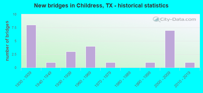
- New bridges - historical statistics
- 81930-1939
- 11940-1949
- 31950-1959
- 41960-1969
- 11970-1979
- 11990-1999
- 72000-2009
- 12010-2019

- Reconstructed bridges - Historical Statistics
- 21950-1959
- 31960-1969
- 01970-1979
- 01980-1989
- 31990-1999
- 12000-2009


- Bridge Condition - Deck
- 70.6%Good
- 17.6%Satisfactory
- 5.9%Fair
- 5.9%Poor

- Bridge Condition - Superstructure
- 5.9%Very good
- 47.1%Good
- 35.3%Satisfactory
- 11.8%Fair

- Bridge Condition - Substructure
- 5.9%Very good
- 35.3%Good
- 35.3%Satisfactory
- 23.5%Fair

- Bridge Condition - Channel
- 27.8%Good
- 50.0%Satisfactory
- 22.2%Fair

- Bridge Condition - Culverts
- 57.1%Good
- 42.9%Satisfactory
Find on map >> Show street view
Structure Number: 250380003106021, Location: 4.18 mi N of US 287 (Lat: 34.491972, Lng: -100.209353), Route carried "on" structure: US 62, Year Built: 2000, Status: Open, Structure Length: 1.68m (5.51ft), Average Daily Traffic: 8,150 (year 2019), Truck Traffic: 19%, Average Future Daily Traffic: 11,410 (year 2039), Features Intersected: CONKLINE CREEK
Minimum Vertical Clearance: 30+ m (98+ ft), Kilometerpoint: 24.018, Lanes on structure: 3, Owner: State Highway Agency, Approaching Roadway Width: 15.5m (50.9ft), Material/Design: Steel, Design/Construction: Culvert, Number Of Spans In Main Unit: 4, Length of Maximum Span: 3.4m (11.2ft)
Condition: Channel: Good, Culverts: Satisfactory, Operating Rating: 44.4 metric tons, Method Used To Determine Operating Rating: No rating analysis performed, Inventory Rating: 32.7 metric tons, Method Used To Determine Inventory Rating: No rating analysis performed, Structural Evaluation: Equal to present minimum criteria, Waterway Adequacy: Equal to present minimum criteria, Approach Roadway Alignment: Equal to present desirable criteria, Designated Inspection Frequency: Every 24 months, Inspection Date: August 2021, Bridge Improvement Cost: $105,000, Roadway Improvement Cost: $26,000, Total Project Cost: $131,000
Find on map >> Show street view
Structure Number: 250380003201001, Location: 1.65MI S OF US 287 (Lat: 34.411989, Lng: -100.234750), Route carried "on" structure: US 62, Year Built: 1930, Year Reconstructed: 2001, Status: Open, Structure Length: 1.01m (3.31ft), Average Daily Traffic: 1,619 (year 2020), Truck Traffic: 12%, Average Future Daily Traffic: 3,730 (year 2039), Features Intersected: DRAW
Minimum Vertical Clearance: 30+ m (98+ ft), Kilometerpoint: 14.454, Lanes on structure: 2, Owner: State Highway Agency, Approaching Roadway Width: 13.7m (44.9ft), Material/Design: Concrete, Design/Construction: Culvert, Number Of Spans In Main Unit: 3, Length of Maximum Span: 3.0m (9.8ft), Curb-To-Curb Width: 13.7m (44.9ft), Out-to-Out Width: 33.3m (109.3ft)
Condition: Channel: Satisfactory, Culverts: Satisfactory, Operating Rating: 32.7 metric tons, Method Used To Determine Operating Rating: Field evaluation and documented engineering judgment, Inventory Rating: 24.5 metric tons, Method Used To Determine Inventory Rating: Field evaluation and documented engineering judgment, Structural Evaluation: Equal to present minimum criteria, Deck Geometry: Superior to present desirable criteria, Waterway Adequacy: Equal to present minimum criteria, Approach Roadway Alignment: Equal to present desirable criteria, Designated Inspection Frequency: Every 24 months, Inspection Date: August 2021
Find on map >> Show street view
Structure Number: 250380003201002, Location: 2.29MI S OF US 287 (Lat: 34.404194, Lng: -100.240603), Route carried "on" structure: US 62, Year Built: 1930, Year Reconstructed: 2001, Status: Open, Structure Length: 1.01m (3.31ft), Average Daily Traffic: 1,210 (year 2020), Truck Traffic: 13%, Average Future Daily Traffic: 2,620 (year 2033), Features Intersected: DRAW
Minimum Vertical Clearance: 30+ m (98+ ft), Kilometerpoint: 13.066, Lanes on structure: 3, Owner: State Highway Agency, Approaching Roadway Width: 15.2m (49.9ft), Material/Design: Concrete, Design/Construction: Culvert, Number Of Spans In Main Unit: 3, Length of Maximum Span: 3.0m (9.8ft)
Condition: Channel: Fair, Culverts: Good, Operating Rating: 32.7 metric tons, Method Used To Determine Operating Rating: Field evaluation and documented engineering judgment, Inventory Rating: 24.5 metric tons, Method Used To Determine Inventory Rating: Field evaluation and documented engineering judgment, Structural Evaluation: Equal to present minimum criteria, Waterway Adequacy: Equal to present minimum criteria, Approach Roadway Alignment: Equal to present desirable criteria, Designated Inspection Frequency: Every 24 months, Inspection Date: August 2021
Find on map >> Show street view
Structure Number: 250380003201005, Location: 5.08MI S US 287 (Lat: 34.374425, Lng: -100.272392), Route carried "on" structure: US 62, Year Built: 1930, Year Reconstructed: 2001, Status: Open, Structure Length: 0.67m (2.20ft), Average Daily Traffic: 1,051 (year 2020), Truck Traffic: 13%, Average Future Daily Traffic: 2,090 (year 2033), Features Intersected: DRAW
Minimum Vertical Clearance: 30+ m (98+ ft), Kilometerpoint: 8.607, Lanes on structure: 2, Owner: State Highway Agency, Approaching Roadway Width: 13.7m (44.9ft), Material/Design: Concrete, Design/Construction: Culvert, Number Of Spans In Main Unit: 2, Length of Maximum Span: 3.0m (9.8ft), Curb-To-Curb Width: 13.4m (44.0ft), Out-to-Out Width: 29.7m (97.4ft)
Condition: Channel: Satisfactory, Culverts: Satisfactory, Operating Rating: 32.7 metric tons, Method Used To Determine Operating Rating: Field evaluation and documented engineering judgment, Inventory Rating: 24.5 metric tons, Method Used To Determine Inventory Rating: Field evaluation and documented engineering judgment, Structural Evaluation: Equal to present minimum criteria, Deck Geometry: Equal to present desirable criteria, Waterway Adequacy: Equal to present minimum criteria, Approach Roadway Alignment: Equal to present desirable criteria, Designated Inspection Frequency: Every 24 months, Inspection Date: August 2021, Deck Structure Type: Concrete Cast-file-Place, Wearing Surface/Protective System: Wearing Surface: Bituminous
Find on map >> Show street view
Structure Number: 250380003201023, Location: 3.67MI S US 287 (Lat: 34.386478, Lng: -100.252894), Route carried "on" structure: US 62, Year Built: 2002, Status: Open, Structure Length: 3.96m (12.99ft), Average Daily Traffic: 1,210 (year 2020), Truck Traffic: 13%, Average Future Daily Traffic: 2,620 (year 2039), Design Load: HS 20, Features Intersected: N SCATTERBRANCH CREEK
Minimum Vertical Clearance: 30+ m (98+ ft), Kilometerpoint: 11.183, Lanes on structure: 2, Owner: State Highway Agency, Approaching Roadway Width: 12.8m (42.0ft), Material/Design: Prestressed concrete, Design/Construction: Stringer/Multi-beam, Number Of Spans In Main Unit: 2, Length of Maximum Span: 19.8m (65.0ft), Curb-To-Curb Width: 13.4m (44.0ft), Out-to-Out Width: 14.0m (45.9ft)
Condition: Deck: Good, Superstructure: Good, Substructure: Good, Channel: Satisfactory, Operating Rating: 54.4 metric tons, Method Used To Determine Operating Rating: Assigned rating based on Load Factor Design (LFD) reported in metric tons, Inventory Rating: 32.7 metric tons, Method Used To Determine Inventory Rating: Assigned rating based on Load Factor Design (LFD) reported in metric tons, Structural Evaluation: Better than present minimum criteria, Deck Geometry: Equal to present desirable criteria, Waterway Adequacy: Superior to present desirable criteria, Approach Roadway Alignment: Equal to present desirable criteria, Designated Inspection Frequency: Every 24 months, Inspection Date: August 2021, Deck Structure Type: Concrete Precast Panels
Find on map >> Show street view
Structure Number: 250380003201024, Location: 4.70MI S US 287 (Lat: 34.378100, Lng: -100.267114), Route carried "on" structure: US 62, Year Built: 2002, Status: Open, Structure Length: 4.88m (16.01ft), Average Daily Traffic: 1,051 (year 2020), Truck Traffic: 13%, Average Future Daily Traffic: 2,090 (year 2039), Design Load: HS 20, Features Intersected: MID SCATTERBRANCH CREEK
Minimum Vertical Clearance: 30+ m (98+ ft), Kilometerpoint: 9.522, Lanes on structure: 2, Owner: State Highway Agency, Approaching Roadway Width: 12.8m (42.0ft), Material/Design: Prestressed concrete, Design/Construction: Stringer/Multi-beam, Number Of Spans In Main Unit: 2, Length of Maximum Span: 24.4m (80.1ft), Curb-To-Curb Width: 13.4m (44.0ft), Out-to-Out Width: 14.0m (45.9ft)
Condition: Deck: Good, Superstructure: Good, Substructure: Good, Channel: Good, Operating Rating: 54.4 metric tons, Method Used To Determine Operating Rating: Assigned rating based on Load Factor Design (LFD) reported in metric tons, Inventory Rating: 32.7 metric tons, Method Used To Determine Inventory Rating: Assigned rating based on Load Factor Design (LFD) reported in metric tons, Structural Evaluation: Better than present minimum criteria, Deck Geometry: Equal to present desirable criteria, Waterway Adequacy: Superior to present desirable criteria, Approach Roadway Alignment: Equal to present desirable criteria, Designated Inspection Frequency: Every 24 months, Inspection Date: August 2021, Deck Structure Type: Concrete Precast Panels
Find on map >> Show street view
Structure Number: 250380004212036, Location: 12.251MI S HALL CL (Lat: 34.438083, Lng: -100.236353), Route carried "on" structure: US 287, Year Built: 1932, Year Reconstructed: 1957, Status: Open, Structure Length: 3.35m (10.99ft), Average Daily Traffic: 4,000 (year 2019), Truck Traffic: 42%, Average Future Daily Traffic: 5,600 (year 2039), Features Intersected: BNSF RAILROAD
Minimum Vertical Clearance: 30+ m (98+ ft), Kilometerpoint: 19.574, Lanes on structure: 2, Owner: State Highway Agency, Approaching Roadway Width: 11.9m (39.0ft), Material/Design: Concrete, Design/Construction: Tee Beam, Number Of Spans In Main Unit: 3, Length of Maximum Span: 11.0m (36.1ft), Curb-To-Curb Width: 13.4m (44.0ft), Out-to-Out Width: 14.0m (45.9ft)
Condition: Deck: Poor, Superstructure: Fair, Substructure: Fair, Operating Rating: 32.7 metric tons, Method Used To Determine Operating Rating: Load Factor (LF), Inventory Rating: 24.5 metric tons, Method Used To Determine Inventory Rating: Load Factor (LF), Structural Evaluation: Somewhat better than minimum adequacy, Deck Geometry: Superior to present desirable criteria, Underclear: Equal to present minimum criteria, Approach Roadway Alignment: Equal to present desirable criteria, Designated Inspection Frequency: Every 24 months, Inspection Date: August 2021, Deck Structure Type: Concrete Cast-file-Place, Wearing Surface/Protective System: Wearing Surface: Bituminous
Find on map >> Show street view
Structure Number: 250380004212041, Location: 8.428MI S HALL CL (Lat: 34.462086, Lng: -100.296469), Route carried "on" structure: US 287, Year Built: 1957, Status: Open, Structure Length: 3.69m (12.11ft), Average Daily Traffic: 5,760 (year 2019), Truck Traffic: 37%, Average Future Daily Traffic: 8,070 (year 2039), Features Intersected: GRASSY CREEK
Minimum Vertical Clearance: 30+ m (98+ ft), Kilometerpoint: 13.436, Lanes on structure: 2, Owner: State Highway Agency, Approaching Roadway Width: 11.6m (38.1ft), Skew: 10 degrees, Material/Design: Concrete, Design/Construction: Stringer/Multi-beam, Number Of Spans In Main Unit: 4, Length of Maximum Span: 9.1m (29.9ft), Curb-To-Curb Width: 13.1m (43.0ft), Out-to-Out Width: 14.0m (45.9ft)
Condition: Deck: Satisfactory, Superstructure: Satisfactory, Substructure: Satisfactory, Channel: Satisfactory, Operating Rating: 68.0 metric tons, Method Used To Determine Operating Rating: Load Factor (LF), Inventory Rating: 40.8 metric tons, Method Used To Determine Inventory Rating: Load Factor (LF), Structural Evaluation: Equal to present minimum criteria, Deck Geometry: Superior to present desirable criteria, Waterway Adequacy: Equal to present minimum criteria, Approach Roadway Alignment: Equal to present desirable criteria, Designated Inspection Frequency: Every 24 months, Inspection Date: August 2021, Deck Structure Type: Concrete Cast-file-Place, Wearing Surface/Protective System: Wearing Surface: Bituminous
Find on map >> Show street view
Structure Number: 250380004212042, Location: 5.826MI S HALL CHILDRESS (Lat: 34.481619, Lng: -100.335108), Route carried "on" structure: US 287, Year Built: 1957, Status: Open, Structure Length: 4.85m (15.91ft), Average Daily Traffic: 5,570 (year 2019), Truck Traffic: 38%, Average Future Daily Traffic: 7,800 (year 2039), Design Load: H 20, Features Intersected: BNSF RAILROAD
Minimum Vertical Clearance: 30+ m (98+ ft), Kilometerpoint: 9.270, Lanes on structure: 2, Owner: State Highway Agency, Approaching Roadway Width: 11.9m (39.0ft), Skew: 12 degrees, Material/Design: Steel continuous, Design/Construction: Stringer/Multi-beam, Number Of Spans In Main Unit: 3, Length of Maximum Span: 17.4m (57.1ft), Curb-To-Curb Width: 13.3m (43.6ft), Out-to-Out Width: 14.0m (45.9ft)
Condition: Deck: Fair, Superstructure: Fair, Substructure: Fair, Operating Rating: 41.7 metric tons, Method Used To Determine Operating Rating: Load Factor (LF), Inventory Rating: 25.4 metric tons, Method Used To Determine Inventory Rating: Load Factor (LF), Structural Evaluation: Somewhat better than minimum adequacy, Deck Geometry: Superior to present desirable criteria, Underclear: Somewhat better than minimum adequacy, Approach Roadway Alignment: Equal to present desirable criteria, Length Of Structure Improvement: 4.85m (15.91ft), Designated Inspection Frequency: Every 24 months, Inspection Date: August 2021, Bridge Improvement Cost: $140,000, Roadway Improvement Cost: $35,000, Total Project Cost: $175,000, Deck Structure Type: Concrete Cast-file-Place, Wearing Surface/Protective System: Wearing Surface: Bituminous
Find on map >> Show street view
Structure Number: 250380004212065, Location: 5.826MI S HALL CL (Lat: 34.481839, Lng: -100.334714), Route carried "on" structure: US 287, Year Built: 1968, Status: Open, Structure Length: 4.79m (15.72ft), Average Daily Traffic: 5,570 (year 2019), Truck Traffic: 38%, Average Future Daily Traffic: 7,800 (year 2039), Design Load: HS 20, Features Intersected: BNSF RAILROAD
Minimum Vertical Clearance: 30+ m (98+ ft), Kilometerpoint: 9.279, Lanes on structure: 2, Owner: State Highway Agency, Approaching Roadway Width: 11.6m (38.1ft), Skew: 12 degrees, Material/Design: Prestressed concrete, Design/Construction: Stringer/Multi-beam, Number Of Spans In Main Unit: 3, Length of Maximum Span: 17.4m (57.1ft), Curb-To-Curb Width: 12.0m (39.4ft), Out-to-Out Width: 12.9m (42.3ft)
Condition: Deck: Good, Superstructure: Satisfactory, Substructure: Satisfactory, Operating Rating: 68.0 metric tons, Method Used To Determine Operating Rating: Load Factor (LF), Inventory Rating: 25.4 metric tons, Method Used To Determine Inventory Rating: Load Factor (LF), Structural Evaluation: Equal to present minimum criteria, Deck Geometry: Better than present minimum criteria, Underclear: Somewhat better than minimum adequacy, Approach Roadway Alignment: Equal to present desirable criteria, Length Of Structure Improvement: 5.70m (18.70ft), Designated Inspection Frequency: Every 24 months, Inspection Date: August 2021, Bridge Improvement Cost: $315,000, Roadway Improvement Cost: $72,000, Total Project Cost: $387,000, Deck Structure Type: Concrete Cast-file-Place, Wearing Surface/Protective System: Wearing Surface: Bituminous
Find on map >> Show street view
Structure Number: 250380004212066, Location: 8.428MI S HALL CL (Lat: 34.462219, Lng: -100.296336), Route carried "on" structure: US 287, Year Built: 1968, Status: Open, Structure Length: 3.66m (12.01ft), Average Daily Traffic: 5,760 (year 2019), Truck Traffic: 37%, Average Future Daily Traffic: 8,070 (year 2039), Design Load: HS 20, Features Intersected: GRASSY CREEK
Minimum Vertical Clearance: 30+ m (98+ ft), Kilometerpoint: 13.427, Lanes on structure: 2, Owner: State Highway Agency, Approaching Roadway Width: 11.6m (38.1ft), Material/Design: Concrete, Design/Construction: Stringer/Multi-beam, Number Of Spans In Main Unit: 3, Length of Maximum Span: 12.2m (40.0ft), Curb-To-Curb Width: 12.6m (41.3ft), Out-to-Out Width: 12.9m (42.3ft)
Condition: Deck: Good, Superstructure: Satisfactory, Substructure: Fair, Channel: Fair, Operating Rating: 63.5 metric tons, Method Used To Determine Operating Rating: Load Factor (LF), Inventory Rating: 38.1 metric tons, Method Used To Determine Inventory Rating: Load Factor (LF), Structural Evaluation: Somewhat better than minimum adequacy, Deck Geometry: Better than present minimum criteria, Waterway Adequacy: Equal to present minimum criteria, Approach Roadway Alignment: Equal to present desirable criteria, Designated Inspection Frequency: Every 24 months, Inspection Date: August 2021, Deck Structure Type: Concrete Cast-file-Place, Wearing Surface/Protective System: Wearing Surface: Bituminous
Find on map >> Show street view
Structure Number: 250380004212067, Location: 12.251MI S HALL CL (Lat: 34.437914, Lng: -100.236431), Route carried "on" structure: US 287, Year Built: 1968, Status: Open, Structure Length: 3.66m (12.01ft), Average Daily Traffic: 4,000 (year 2019), Truck Traffic: 42%, Average Future Daily Traffic: 5,600 (year 2039), Design Load: HS 20, Features Intersected: BNSF RAILROAD
Minimum Vertical Clearance: 30+ m (98+ ft), Kilometerpoint: 19.574, Lanes on structure: 2, Owner: State Highway Agency, Approaching Roadway Width: 11.6m (38.1ft), Skew: 10 degrees, Material/Design: Concrete, Design/Construction: Stringer/Multi-beam, Number Of Spans In Main Unit: 3, Length of Maximum Span: 12.2m (40.0ft), Curb-To-Curb Width: 12.2m (40.0ft), Out-to-Out Width: 12.9m (42.3ft)
Condition: Deck: Good, Superstructure: Satisfactory, Substructure: Fair, Operating Rating: 64.4 metric tons, Method Used To Determine Operating Rating: Load Factor (LF), Inventory Rating: 39.0 metric tons, Method Used To Determine Inventory Rating: Load Factor (LF), Structural Evaluation: Somewhat better than minimum adequacy, Deck Geometry: Better than present minimum criteria, Underclear: Better than present minimum criteria, Approach Roadway Alignment: Equal to present desirable criteria, Designated Inspection Frequency: Every 24 months, Inspection Date: August 2021, Deck Structure Type: Concrete Cast-file-Place, Wearing Surface/Protective System: Wearing Surface: Bituminous
Find on map >> Show street view
Structure Number: 250380004212076, Location: JCT US 287 & FM164 (Lat: 34.453408, Lng: -100.277681), Route carried "on" structure: US 287, Year Built: 2000, Status: Open, Structure Length: 3.05m (10.01ft), Average Daily Traffic: 5,760 (year 2019), Truck Traffic: 37%, Average Future Daily Traffic: 8,070 (year 2039), Design Load: HS 20, Features Intersected: FM 164
Minimum Vertical Clearance: 30+ m (98+ ft), Kilometerpoint: 15.413, Lanes on structure: 2, Lanes under structure: 3, Owner: State Highway Agency, Approaching Roadway Width: 11.6m (38.1ft), Skew: 12 degrees, Material/Design: Prestressed concrete, Design/Construction: Stringer/Multi-beam, Number Of Spans In Main Unit: 1, Length of Maximum Span: 30.5m (100.1ft), Curb-To-Curb Width: 11.6m (38.1ft), Out-to-Out Width: 12.2m (40.0ft)
Condition: Deck: Good, Superstructure: Good, Substructure: Good, Operating Rating: 54.4 metric tons, Method Used To Determine Operating Rating: Assigned rating based on Load Factor Design (LFD) reported in metric tons, Inventory Rating: 32.7 metric tons, Method Used To Determine Inventory Rating: Assigned rating based on Load Factor Design (LFD) reported in metric tons, Structural Evaluation: Better than present minimum criteria, Deck Geometry: Better than present minimum criteria, Underclear: Meets minimum limits, Approach Roadway Alignment: Equal to present desirable criteria, Designated Inspection Frequency: Every 24 months, Inspection Date: August 2021, Deck Structure Type: Concrete Precast Panels
Find on map >> Show street view
Structure Number: 250380004212077, Location: JSCT US 287 & FM164 (Lat: 34.453306, Lng: -100.278078), Route carried "on" structure: US 287, Year Built: 2000, Status: Open, Structure Length: 3.05m (10.01ft), Average Daily Traffic: 5,760 (year 2019), Truck Traffic: 37%, Average Future Daily Traffic: 8,070 (year 2039), Design Load: HS 20, Features Intersected: FM 164
Minimum Vertical Clearance: 30+ m (98+ ft), Kilometerpoint: 15.419, Lanes on structure: 2, Lanes under structure: 3, Owner: State Highway Agency, Approaching Roadway Width: 11.6m (38.1ft), Skew: 12 degrees, Material/Design: Prestressed concrete, Design/Construction: Stringer/Multi-beam, Number Of Spans In Main Unit: 1, Length of Maximum Span: 30.5m (100.1ft), Curb-To-Curb Width: 11.6m (38.1ft), Out-to-Out Width: 12.2m (40.0ft)
Condition: Deck: Good, Superstructure: Good, Substructure: Good, Operating Rating: 54.4 metric tons, Method Used To Determine Operating Rating: Assigned rating based on Load Factor Design (LFD) reported in metric tons, Inventory Rating: 32.7 metric tons, Method Used To Determine Inventory Rating: Assigned rating based on Load Factor Design (LFD) reported in metric tons, Structural Evaluation: Better than present minimum criteria, Deck Geometry: Better than present minimum criteria, Underclear: Meets minimum limits, Approach Roadway Alignment: Equal to present desirable criteria, Designated Inspection Frequency: Every 24 months, Inspection Date: August 2021, Deck Structure Type: Concrete Precast Panels
Find on map >> Show street view
Structure Number: 250380004301001, Location: 2.741MI E OF CHILDRESS CT (Lat: 34.406458, Lng: -100.147256), Route carried "on" structure: US 287, Year Built: 1931, Year Reconstructed: 1955, Status: Open, Structure Length: 2.62m (8.60ft), Average Daily Traffic: 5,940 (year 2019), Truck Traffic: 26%, Average Future Daily Traffic: 8,320 (year 2039), Design Load: H 15, Features Intersected: NORTH GROESBECK CREEK
Minimum Vertical Clearance: 30+ m (98+ ft), Kilometerpoint: 7.454, Lanes on structure: 2, Owner: State Highway Agency, Approaching Roadway Width: 11.9m (39.0ft), Skew: 10 degrees, Material/Design: Concrete, Design/Construction: Tee Beam, Number Of Spans In Main Unit: 3, Length of Maximum Span: 8.8m (28.9ft), Curb-To-Curb Width: 11.9m (39.0ft), Out-to-Out Width: 13.0m (42.7ft)
Condition: Deck: Satisfactory, Superstructure: Satisfactory, Substructure: Good, Channel: Satisfactory, Operating Rating: 51.7 metric tons, Method Used To Determine Operating Rating: Load Factor (LF), Inventory Rating: 30.8 metric tons, Method Used To Determine Inventory Rating: Load Factor (LF), Structural Evaluation: Equal to present minimum criteria, Deck Geometry: Better than present minimum criteria, Waterway Adequacy: Equal to present minimum criteria, Approach Roadway Alignment: Equal to present desirable criteria, Designated Inspection Frequency: Every 24 months, Inspection Date: August 2021, Deck Structure Type: Concrete Cast-file-Place, Wearing Surface/Protective System: Wearing Surface: Bituminous
Find on map >> Show street view
Structure Number: 250380004301148, Location: 2.741MI E OF CHILDRESS CT (Lat: 34.406619, Lng: -100.147164), Route carried "on" structure: US 287, Year Built: 1971, Status: Open, Structure Length: 2.44m (8.01ft), Average Daily Traffic: 5,940 (year 2019), Truck Traffic: 26%, Average Future Daily Traffic: 8,320 (year 2039), Design Load: HS 20, Features Intersected: NORTH GROESBECK CREEK
Minimum Vertical Clearance: 30+ m (98+ ft), Kilometerpoint: 7.454, Lanes on structure: 2, Owner: State Highway Agency, Approaching Roadway Width: 11.9m (39.0ft), Skew: 10 degrees, Material/Design: Concrete, Design/Construction: Stringer/Multi-beam, Number Of Spans In Main Unit: 2, Length of Maximum Span: 12.2m (40.0ft), Curb-To-Curb Width: 12.7m (41.7ft), Out-to-Out Width: 13.5m (44.3ft)
Condition: Deck: Good, Superstructure: Good, Substructure: Good, Channel: Good, Operating Rating: 68.0 metric tons, Method Used To Determine Operating Rating: Load Factor (LF), Inventory Rating: 40.8 metric tons, Method Used To Determine Inventory Rating: Load Factor (LF), Structural Evaluation: Better than present minimum criteria, Deck Geometry: Better than present minimum criteria, Waterway Adequacy: Equal to present minimum criteria, Approach Roadway Alignment: Equal to present desirable criteria, Designated Inspection Frequency: Every 24 months, Inspection Date: August 2021, Deck Structure Type: Concrete Cast-file-Place, Wearing Surface/Protective System: Wearing Surface: Bituminous
Find on map >> Show street view
Structure Number: 250380070402001, Location: 2.270MI NE JCT US287 IN C (Lat: 34.438719, Lng: -100.172258), Route carried "on" structure: State highway 268, Year Built: 1938, Year Reconstructed: 1960, Status: Open, Structure Length: 0.76m (2.49ft), Average Daily Traffic: 180 (year 2020), Truck Traffic: 30%, Average Future Daily Traffic: 270 (year 2033), Features Intersected: DRAW
Minimum Vertical Clearance: 30+ m (98+ ft), Kilometerpoint: 3.661, Lanes on structure: 2, Owner: State Highway Agency, Approaching Roadway Width: 7.3m (24.0ft), Material/Design: Concrete, Design/Construction: Slab, Number Of Spans In Main Unit: 2, Length of Maximum Span: 3.7m (12.1ft), Curb-To-Curb Width: 11.0m (36.1ft), Out-to-Out Width: 11.3m (37.1ft)
Condition: Deck: Good, Superstructure: Good, Substructure: Satisfactory, Channel: Satisfactory, Operating Rating: 37.2 metric tons, Method Used To Determine Operating Rating: Load Factor (LF), Inventory Rating: 22.7 metric tons, Method Used To Determine Inventory Rating: Load Factor (LF), Structural Evaluation: Equal to present minimum criteria, Deck Geometry: Equal to present desirable criteria, Waterway Adequacy: Equal to present minimum criteria, Approach Roadway Alignment: Equal to present desirable criteria, Designated Inspection Frequency: Every 24 months, Inspection Date: August 2021, Deck Structure Type: Concrete Cast-file-Place, Wearing Surface/Protective System: Wearing Surface: Bituminous
Find on map >> Show street view
Structure Number: 250380070402002, Location: 2.559MI NE JCT US287 IN C (Lat: 34.438558, Lng: -100.166736), Route carried "on" structure: State highway 268, Year Built: 1938, Year Reconstructed: 1960, Status: Open, Structure Length: 0.76m (2.49ft), Average Daily Traffic: 180 (year 2020), Truck Traffic: 30%, Average Future Daily Traffic: 270 (year 2033), Features Intersected: DRAW
Minimum Vertical Clearance: 30+ m (98+ ft), Kilometerpoint: 4.118, Lanes on structure: 2, Owner: State Highway Agency, Approaching Roadway Width: 7.6m (24.9ft), Material/Design: Concrete, Design/Construction: Slab, Number Of Spans In Main Unit: 2, Length of Maximum Span: 3.7m (12.1ft), Curb-To-Curb Width: 11.0m (36.1ft), Out-to-Out Width: 11.3m (37.1ft)
Condition: Deck: Good, Superstructure: Good, Substructure: Satisfactory, Channel: Fair, Operating Rating: 37.2 metric tons, Method Used To Determine Operating Rating: Load Factor (LF), Inventory Rating: 22.7 metric tons, Method Used To Determine Inventory Rating: Load Factor (LF), Structural Evaluation: Equal to present minimum criteria, Deck Geometry: Equal to present desirable criteria, Waterway Adequacy: Equal to present minimum criteria, Approach Roadway Alignment: Equal to present desirable criteria, Designated Inspection Frequency: Every 24 months, Inspection Date: August 2021, Deck Structure Type: Concrete Cast-file-Place, Wearing Surface/Protective System: Wearing Surface: Bituminous
Find on map >> Show street view
Structure Number: 250380070402015, Location: 4.200MI NE JCT US287 IN C (Lat: 34.437819, Lng: -100.138269), Route carried "on" structure: State highway 268, Year Built: 1938, Year Reconstructed: 1960, Status: Open, Structure Length: 0.76m (2.49ft), Average Daily Traffic: 129 (year 2020), Truck Traffic: 30%, Average Future Daily Traffic: 230 (year 2033), Features Intersected: DRAW
Minimum Vertical Clearance: 30+ m (98+ ft), Kilometerpoint: 6.745, Lanes on structure: 2, Owner: State Highway Agency, Approaching Roadway Width: 6.7m (22.0ft), Material/Design: Concrete, Design/Construction: Slab, Number Of Spans In Main Unit: 2, Length of Maximum Span: 3.0m (9.8ft), Curb-To-Curb Width: 11.0m (36.1ft), Out-to-Out Width: 11.3m (37.1ft)
Condition: Deck: Good, Superstructure: Good, Substructure: Satisfactory, Channel: Satisfactory, Operating Rating: 37.2 metric tons, Method Used To Determine Operating Rating: Load Factor (LF), Inventory Rating: 22.7 metric tons, Method Used To Determine Inventory Rating: Load Factor (LF), Structural Evaluation: Equal to present minimum criteria, Deck Geometry: Equal to present desirable criteria, Waterway Adequacy: Equal to present minimum criteria, Approach Roadway Alignment: Equal to present desirable criteria, Designated Inspection Frequency: Every 24 months, Inspection Date: August 2021, Deck Structure Type: Concrete Cast-file-Place, Wearing Surface/Protective System: Wearing Surface: Bituminous
Find on map >> Show street view
Structure Number: 250380191401001, Location: 3.792MI W US 83 (Lat: 34.382069, Lng: -100.328681), Route carried "on" structure: State highway 94, Year Built: 1954, Year Reconstructed: 2006, Status: Open, Structure Length: 0.67m (2.20ft), Average Daily Traffic: 124 (year 2020), Truck Traffic: 9%, Average Future Daily Traffic: 520 (year 2034), Features Intersected: DRAW
Minimum Vertical Clearance: 30+ m (98+ ft), Kilometerpoint: 6.103, Lanes on structure: 2, Owner: State Highway Agency, Approaching Roadway Width: 8.5m (27.9ft), Material/Design: Steel, Design/Construction: Culvert, Number Of Spans In Main Unit: 2, Length of Maximum Span: 2.7m (8.9ft)
Condition: Channel: Satisfactory, Culverts: Good, Operating Rating: 32.7 metric tons, Method Used To Determine Operating Rating: Field evaluation and documented engineering judgment, Inventory Rating: 24.5 metric tons, Method Used To Determine Inventory Rating: Field evaluation and documented engineering judgment, Structural Evaluation: Equal to present minimum criteria, Waterway Adequacy: Superior to present desirable criteria, Approach Roadway Alignment: Equal to present desirable criteria, Designated Inspection Frequency: Every 24 months, Inspection Date: August 2021
Find on map >> Show street view
Structure Number: 250380254502001, Location: 1.7 MI S OF FM 2042 (Lat: 34.380178, Lng: -100.210978), Route carried "on" structure: State highway 3031, Year Built: 1968, Status: Open, Structure Length: 0.76m (2.49ft), Average Daily Traffic: 233 (year 2020), Truck Traffic: 5%, Average Future Daily Traffic: 370 (year 2033), Design Load: HS 20, Features Intersected: DRAW
Minimum Vertical Clearance: 30+ m (98+ ft), Kilometerpoint: 4.305, Lanes on structure: 2, Owner: State Highway Agency, Approaching Roadway Width: 6.1m (20.0ft), Skew: 3 degrees, Material/Design: Concrete, Design/Construction: Culvert, Number Of Spans In Main Unit: 2, Length of Maximum Span: 3.0m (9.8ft)
Condition: Channel: Satisfactory, Culverts: Good, Operating Rating: 39.9 metric tons, Method Used To Determine Operating Rating: Load Factor (LF), Inventory Rating: 23.6 metric tons, Method Used To Determine Inventory Rating: Load Factor (LF), Structural Evaluation: Equal to present minimum criteria, Waterway Adequacy: Better than present minimum criteria, Approach Roadway Alignment: Equal to present desirable criteria, Designated Inspection Frequency: Every 24 months, Inspection Date: August 2021
Find on map >> Show street view
Structure Number: 250380355401001, Location: 0.81 MI W OF US 62 (Lat: 34.410550, Lng: -100.250783), Route carried "on" structure: State highway 2042, Year Built: 1990, Status: Open, Structure Length: 0.73m (2.40ft), Average Daily Traffic: 246 (year 2020), Truck Traffic: 11%, Average Future Daily Traffic: 890 (year 2033), Design Load: HS 20, Features Intersected: DRAW
Minimum Vertical Clearance: 30+ m (98+ ft), Kilometerpoint: 3.917, Lanes on structure: 2, Owner: State Highway Agency, Approaching Roadway Width: 7.3m (24.0ft), Skew: 3 degrees, Material/Design: Concrete, Design/Construction: Culvert, Number Of Spans In Main Unit: 3, Length of Maximum Span: 2.1m (6.9ft), Curb-To-Curb Width: 7.5m (24.6ft), Out-to-Out Width: 8.9m (29.2ft)
Condition: Channel: Good, Culverts: Good, Operating Rating: 39.9 metric tons, Method Used To Determine Operating Rating: Load Factor (LF), Inventory Rating: 23.6 metric tons, Method Used To Determine Inventory Rating: Load Factor (LF), Structural Evaluation: Equal to present minimum criteria, Deck Geometry: Somewhat better than minimum adequacy, Waterway Adequacy: Better than present minimum criteria, Approach Roadway Alignment: Equal to present desirable criteria, Designated Inspection Frequency: Every 48 months, Inspection Date: August 2021, Deck Structure Type: Concrete Cast-file-Place, Wearing Surface/Protective System: Wearing Surface: Bituminous
Find on map >> Show street view
Structure Number: 250380630781001, Location: 0.304 MI W OF US 62/83 (Lat: 34.380786, Lng: -100.267258), Route carried "on" structure: State highway 94, Year Built: 2017, Status: Open, Structure Length: 1.52m (4.99ft), Average Daily Traffic: 124 (year 2020), Truck Traffic: 13%, Average Future Daily Traffic: 400 (year 2033), Design Load: HL 93, Features Intersected: Draw
Minimum Vertical Clearance: 30+ m (98+ ft), Kilometerpoint: 0.489, Lanes on structure: 2, Owner: State Highway Agency, Approaching Roadway Width: 8.5m (27.9ft), Material/Design: Prestressed concrete, Design/Construction: Slab, Number Of Spans In Main Unit: 1, Length of Maximum Span: 15.2m (49.9ft), Curb-To-Curb Width: 9.1m (29.9ft), Out-to-Out Width: 9.8m (32.2ft)
Condition: Deck: Good, Superstructure: Very good, Substructure: Very good, Channel: Good, Operating Rating: 54.4 metric tons, Method Used To Determine Operating Rating: Assigned ratings based on Load and Resistance Factor Design (LRFD) reported in metric tons, Inventory Rating: 32.7 metric tons, Method Used To Determine Inventory Rating: Assigned ratings based on Load and Resistance Factor Design (LRFD) reported in metric tons, Structural Evaluation: Equal to present desirable criteria, Deck Geometry: Equal to present minimum criteria, Waterway Adequacy: Better than present minimum criteria, Approach Roadway Alignment: Equal to present desirable criteria, Designated Inspection Frequency: Every 24 months, Inspection Date: August 2021, Deck Structure Type: Concrete Cast-file-Place
Find on map >> Show street view
Structure Number: 250380AA0148001, Location: 1.00 MI S OF US 287 (Lat: 34.391153, Lng: -100.143997), Route carried "on" structure: County highway , Year Built: 1940, Status: Open, Structure Length: 0.76m (2.49ft), Average Daily Traffic: 25 (year 2010), Average Future Daily Traffic: 25 (year 2030), Features Intersected: DRAW, Facility Carried by Structure: CR 17
Minimum Vertical Clearance: 30+ m (98+ ft), Kilometerpoint: 1.529, Lanes on structure: 2, Owner: County Highway Agency, Approaching Roadway Width: 6.7m (22.0ft), Material/Design: Concrete, Design/Construction: Slab, Number Of Spans In Main Unit: 2, Length of Maximum Span: 3.7m (12.1ft), Curb-To-Curb Width: 6.7m (22.0ft), Out-to-Out Width: 7.1m (23.3ft)
Condition: Deck: Satisfactory, Superstructure: Satisfactory, Substructure: Satisfactory, Channel: Fair, Operating Rating: 32.7 metric tons, Method Used To Determine Operating Rating: Field evaluation and documented engineering judgment, Inventory Rating: 24.5 metric tons, Method Used To Determine Inventory Rating: Field evaluation and documented engineering judgment, Structural Evaluation: Equal to present minimum criteria, Deck Geometry: Somewhat better than minimum adequacy, Waterway Adequacy: Better than present minimum criteria, Approach Roadway Alignment: Equal to present desirable criteria, Designated Inspection Frequency: Every 24 months, Inspection Date: August 2020, Deck Structure Type: Concrete Cast-file-Place, Wearing Surface/Protective System: Wearing Surface: Gravel
Find on map >> Show street view
Structure Number: 250380004212076, Location: JCT US 287 & FM164 (Lat: 34.453408, Lng: -100.277681), Route carried "under" structure: State highway 164, Year Built: 2000, Structure Length: 0. m, Average Daily Traffic: 420 (year 2013), Truck Traffic: 4%, Features Intersected: FM 164, Facility Carried by Structure: US 287 NB
Minimum Vertical Clearance: 5.28m (17.32ft), Kilometerpoint: 40.942, Lanes on structure: 2, Lanes under structure: 3, Material/Design: Prestressed concrete, Design/Construction: Stringer/Multi-beam, Length of Maximum Span: 30.5m (100.1ft)
Find on map >> Show street view
Structure Number: 250380004212077, Location: JSCT US 287 & FM164 (Lat: 34.453306, Lng: -100.278078), Route carried "under" structure: State highway 164, Year Built: 2000, Structure Length: 0. m, Average Daily Traffic: 420 (year 2011), Truck Traffic: 10%, Features Intersected: FM 164, Facility Carried by Structure: US 287 SB
Minimum Vertical Clearance: 5.13m (16.83ft), Kilometerpoint: 39.332, Lanes on structure: 2, Lanes under structure: 3, Material/Design: Prestressed concrete, Design/Construction: Stringer/Multi-beam, Length of Maximum Span: 30.5m (100.1ft)