Bridge Statistics for Carteret, New Jersey (NJ)
Condition, Traffic, Stress, Structural Evaluation, Project Costs
- National Bridge Inventory (NBI) Statistics
- 21Number of bridges
- 541ft / 165mTotal length
- $15,391,000Total costs
- 492,037Total average daily traffic
- 42,287Total average daily truck traffic
- National Bridge Inventory (NBI) Registered Bridges for Carteret
- No street view available for this location
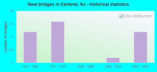
- New bridges - historical statistics
- 61960-1969
- 81970-1979
- 11990-1999
- 62000-2009

- Reconstructed bridges - Historical Statistics
- 31980-1989
- 21990-1999
- 12000-2009


- Bridge Condition - Deck
- 75.0%Good
- 25.0%Satisfactory

- Bridge Condition - Superstructure
- 12.5%Very good
- 75.0%Satisfactory
- 12.5%Fair

- Bridge Condition - Substructure
- 12.5%Very good
- 37.5%Good
- 37.5%Satisfactory
- 12.5%Fair
Find on map >> Show street view
Structure Number: M0958, Location: 0.5 MI S OF RAHWAY RIVER (Lat: 40.593333, Lng: -74.235000), Route carried "on" structure: County highway 602, Year Built: 1970, Year Reconstructed: 1991, Status: Open, Structure Length: 21.18m (69.49ft), Average Daily Traffic: 18,741 (year 2019), Truck Traffic: 4%, Average Future Daily Traffic: 22,868 (year 2039), Design Load: HS 20, Features Intersected: NJ TPK,RAMPS SIT,SOT,CRR, Facility Carried by Structure: ROOSEVELT AVENUE
Minimum Vertical Clearance: 30+ m (98+ ft), Kilometerpoint: 2.189, Lanes on structure: 2, Lanes under structure: 19, Owner: State Toll Authority, Approaching Roadway Width: 13.7m (44.9ft), Skew: 3 degrees, Material/Design: Steel, Design/Construction: Stringer/Multi-beam, Number Of Spans In Main Unit: 6, Length of Maximum Span: 41.8m (137.1ft), Curb or Sidewalk Widths: Left: 1.8m (5.9ft), Right: 0.6m (2.0ft), Curb-To-Curb Width: 13.7m (44.9ft), Out-to-Out Width: 16.8m (55.1ft)
Condition: Deck: Satisfactory, Superstructure: Satisfactory, Substructure: Satisfactory, Operating Rating: 22.7 metric tons, Method Used To Determine Operating Rating: Load and Resistance Factor Rating (LRFR) rating reported by rating factor(RF) method using HL-93 loadings, Inventory Rating: 17.5 metric tons, Method Used To Determine Inventory Rating: Load and Resistance Factor Rating (LRFR) rating reported by rating factor(RF) method using HL-93 loadings, Structural Evaluation: Meets minimum limits, Deck Geometry: Superior to present desirable criteria, Underclear: High priority of corrective action, Approach Roadway Alignment: Better than present minimum criteria, Length Of Structure Improvement: 21.18m (69.49ft), Designated Inspection Frequency: Every 24 months, Inspection Date: March 2021, Bridge Improvement Cost: $100,000, Roadway Improvement Cost: $50,000, Total Project Cost: $250,000 ( Estimate for 2017), Deck Structure Type: Concrete Cast-file-Place, Wearing Surface/Protective System: Wearing Surface: Monolithic Concrete
Find on map >> Show street view
Structure Number: M09589A, Location: INTERCHANGE 12 (Lat: 40.594631, Lng: -74.233769), Route carried "on" structure: Ramp Interstate 95, Year Built: 1961, Year Reconstructed: 1994, Status: Open, Structure Length: 15.39m (50.49ft), Average Daily Traffic: 1,860 (year 2019), Truck Traffic: 1%, Average Future Daily Traffic: 2,200 (year 2039), Design Load: HS 20, Features Intersected: NJ TPK SNO RWY,CRR OF NJ, Facility Carried by Structure: NJTPK INT.12 R.SIT
Minimum Vertical Clearance: 30+ m (98+ ft), Kilometerpoint: 81.320, Lanes on structure: 1, Lanes under structure: 4, Toll: On toll road, Owner: State Toll Authority, Approaching Roadway Width: 7.9m (25.9ft), Skew: 4 degrees, Material/Design: Steel, Design/Construction: Stringer/Multi-beam, Number Of Spans In Main Unit: 6, Length of Maximum Span: 33.8m (110.9ft), Curb or Sidewalk Widths: Left: 0.6m (2.0ft), Right: 0.6m (2.0ft), Curb-To-Curb Width: 7.9m (25.9ft), Out-to-Out Width: 9.8m (32.2ft)
Condition: Deck: Good, Superstructure: Satisfactory, Substructure: Satisfactory, Operating Rating: 46.3 metric tons, Method Used To Determine Operating Rating: Load and Resistance Factor Rating (LRFR) rating reported by rating factor(RF) method using HL-93 loadings, Inventory Rating: 36.0 metric tons, Method Used To Determine Inventory Rating: Load and Resistance Factor Rating (LRFR) rating reported by rating factor(RF) method using HL-93 loadings, Structural Evaluation: Equal to present minimum criteria, Deck Geometry: Equal to present desirable criteria, Underclear: Meets minimum limits, Approach Roadway Alignment: Better than present minimum criteria, Designated Inspection Frequency: Every 24 months, Critical Feature Inspection Frequency: Every 24 months, Inspection Date: July 2021, Critical Feature Inspection Date: July 2021, Deck Structure Type: Concrete Cast-file-Place, Wearing Surface/Protective System: Wearing Surface: Latex Concrete
Find on map >> Show street view
Structure Number: M09592A, Location: INTERCHANGE 12 (Lat: 40.595533, Lng: -74.235325), Route carried "on" structure: Ramp Interstate 95, Year Built: 1961, Year Reconstructed: 1995, Status: Open, Structure Length: 24.35m (79.89ft), Average Daily Traffic: 12,600 (year 2019), Truck Traffic: 10%, Average Future Daily Traffic: 15,000 (year 2039), Design Load: HS 20, Features Intersected: NJ TPK RWYS & CRR OF NJ, Facility Carried by Structure: NJTPK RAMPS TS&NT
Minimum Vertical Clearance: 30+ m (98+ ft), Kilometerpoint: 81.320, Lanes on structure: 2, Lanes under structure: 16, Toll: On toll road, Owner: State Toll Authority, Approaching Roadway Width: 15.2m (49.9ft), Skew: 20 degrees, Material/Design: Steel, Design/Construction: Stringer/Multi-beam, Number Of Spans In Main Unit: 9, Length of Maximum Span: 34.4m (112.9ft), Curb or Sidewalk Widths: Left: 0.6m (2.0ft), Right: 0.6m (2.0ft), Curb-To-Curb Width: 14.0m (45.9ft), Out-to-Out Width: 17.1m (56.1ft)
Condition: Deck: Satisfactory, Superstructure: Satisfactory, Substructure: Fair, Operating Rating: 30.5 metric tons, Method Used To Determine Operating Rating: Load and Resistance Factor Rating (LRFR) rating reported by rating factor(RF) method using HL-93 loadings, Inventory Rating: 23.7 metric tons, Method Used To Determine Inventory Rating: Load and Resistance Factor Rating (LRFR) rating reported by rating factor(RF) method using HL-93 loadings, Structural Evaluation: Somewhat better than minimum adequacy, Deck Geometry: Superior to present desirable criteria, Underclear: High priority of replacement, Approach Roadway Alignment: Better than present minimum criteria, Length Of Structure Improvement: 24.35m (79.89ft), Designated Inspection Frequency: Every 24 months, Inspection Date: July 2021, Bridge Improvement Cost: $8,480,000, Roadway Improvement Cost: $1,060,000, Total Project Cost: $14,278,000 ( Estimate for 2015), Deck Structure Type: Concrete Cast-file-Place, Wearing Surface/Protective System: Wearing Surface: Bituminous
Find on map >> Show street view
Structure Number: M09592B, Location: INTERCHANGE 12 (Lat: 40.594147, Lng: -74.233786), Route carried "on" structure: Ramp Interstate 95, Year Built: 1970, Status: Open, Structure Length: 8.02m (26.31ft), Average Daily Traffic: 4,100 (year 2019), Truck Traffic: 10%, Average Future Daily Traffic: 4,900 (year 2039), Design Load: HS 20, Features Intersected: CENTRAL RAILROAD OF NJ, Facility Carried by Structure: NJTPK INT.12 R.SOT
Minimum Vertical Clearance: 30+ m (98+ ft), Kilometerpoint: 81.288, Lanes on structure: 1, Toll: On toll road, Owner: State Toll Authority, Approaching Roadway Width: 7.9m (25.9ft), Material/Design: Steel continuous, Design/Construction: Stringer/Multi-beam, Number Of Spans In Main Unit: 2, Length of Maximum Span: 47.2m (154.9ft), Curb or Sidewalk Widths: Left: 0.6m (2.0ft), Right: 0.6m (2.0ft), Curb-To-Curb Width: 7.9m (25.9ft), Out-to-Out Width: 9.8m (32.2ft)
Condition: Deck: Good, Superstructure: Fair, Substructure: Good, Operating Rating: 38.9 metric tons, Method Used To Determine Operating Rating: Load and Resistance Factor Rating (LRFR) rating reported by rating factor(RF) method using HL-93 loadings, Inventory Rating: 30.1 metric tons, Method Used To Determine Inventory Rating: Load and Resistance Factor Rating (LRFR) rating reported by rating factor(RF) method using HL-93 loadings, Structural Evaluation: Somewhat better than minimum adequacy, Deck Geometry: Equal to present desirable criteria, Underclear: Somewhat better than minimum adequacy, Approach Roadway Alignment: Better than present minimum criteria, Designated Inspection Frequency: Every 24 months, Inspection Date: July 2021, Deck Structure Type: Concrete Cast-file-Place, Wearing Surface/Protective System: Wearing Surface: Bituminous
Find on map >> Show street view
Structure Number: M09595A, Location: .1 Mi E of Int. 12 (Lat: 40.592661, Lng: -74.228750), Route carried "on" structure: Ramp Interstate 95, Year Built: 2009, Status: Open, Structure Length: 60.08m (197.11ft), Average Daily Traffic: 3,800 (year 2021), Truck Traffic: 9%, Average Future Daily Traffic: 4,560 (year 2041), Design Load: HS 20+Mod, Features Intersected: Ramps TE2 & ET2, Facility Carried by Structure: NJTPK Ramps ET1&WT
Minimum Vertical Clearance: 30+ m (98+ ft), Kilometerpoint: 81.417, Lanes on structure: 1, Lanes under structure: 9, Toll: On toll road, Owner: State Toll Authority, Approaching Roadway Width: 7.6m (24.9ft), Skew: 9 degrees, Material/Design: Steel, Design/Construction: Stringer/Multi-beam, Number Of Spans In Main Unit: 22, Length of Maximum Span: 43.3m (142.1ft), Curb-To-Curb Width: 7.7m (25.3ft), Out-to-Out Width: 8.9m (29.2ft)
Condition: Deck: Good, Superstructure: Very good, Substructure: Very good, Operating Rating: 32.1 metric tons, Method Used To Determine Operating Rating: Load and Resistance Factor Rating (LRFR) rating reported by rating factor(RF) method using HL-93 loadings, Inventory Rating: 24.6 metric tons, Method Used To Determine Inventory Rating: Load and Resistance Factor Rating (LRFR) rating reported by rating factor(RF) method using HL-93 loadings, Structural Evaluation: Equal to present minimum criteria, Deck Geometry: Better than present minimum criteria, Underclear: Somewhat better than minimum adequacy, Approach Roadway Alignment: Superior to present desirable criteria, Designated Inspection Frequency: Every 24 months, Critical Feature Inspection Frequency: Every 24 months, Inspection Date: July 2021, Critical Feature Inspection Date: July 2021, Deck Structure Type: Concrete Cast-file-Place, Wearing Surface/Protective System: Deck Protection: Epoxy Coated Reinforcing
Find on map >> Show street view
Structure Number: M09595B, Location: .7 Mi. E. of Int. 12 (Lat: 40.592669, Lng: -74.228458), Route carried "on" structure: Ramp Interstate 95, Year Built: 2004, Year Reconstructed: 2006, Status: Open, Structure Length: 0.82m (2.69ft), Average Daily Traffic: 3,750 (year 2021), Truck Traffic: 4%, Average Future Daily Traffic: 4,500 (year 2041), Design Load: HS 20+Mod, Features Intersected: Creek (Culvert), Facility Carried by Structure: NJTPKRampsWT,ET&TE
Minimum Vertical Clearance: 30+ m (98+ ft), Kilometerpoint: 81.417, Lanes on structure: 5, Toll: On toll road, Owner: State Toll Authority, Approaching Roadway Width: 38.1m (125.0ft), Skew: 23 degrees, Material/Design: Concrete, Design/Construction: Culvert, Number Of Spans In Main Unit: 1, Length of Maximum Span: 8.2m (26.9ft), Curb-To-Curb Width: 38.1m (125.0ft), Out-to-Out Width: 48.3m (158.5ft)
Condition: Channel: Very good, Culverts: Good, Operating Rating: 50.9 metric tons, Method Used To Determine Operating Rating: Load and Resistance Factor Rating (LRFR) rating reported by rating factor(RF) method using HL-93 loadings, Inventory Rating: 39.2 metric tons, Method Used To Determine Inventory Rating: Load and Resistance Factor Rating (LRFR) rating reported by rating factor(RF) method using HL-93 loadings, Structural Evaluation: Better than present minimum criteria, Deck Geometry: Superior to present desirable criteria, Waterway Adequacy: Equal to present desirable criteria, Approach Roadway Alignment: Equal to present desirable criteria, Designated Inspection Frequency: Every 24 months, Inspection Date: July 2021
Find on map >> Show street view
Structure Number: M09596A, Location: INTERCHANGE 12 (Lat: 40.595156, Lng: -74.233306), Route carried "on" structure: Ramp Interstate 95, Year Built: 1960, Year Reconstructed: 1995, Status: Open, Structure Length: 15.54m (50.98ft), Average Daily Traffic: 3,720 (year 2019), Truck Traffic: 10%, Average Future Daily Traffic: 4,460 (year 2039), Design Load: HS 20+Mod, Features Intersected: NJTPK SNO RDWY & CONRAIL, Facility Carried by Structure: NJTPK INT12 RP TNI
Minimum Vertical Clearance: 30+ m (98+ ft), Kilometerpoint: 81.417, Lanes on structure: 1, Lanes under structure: 4, Toll: On toll road, Owner: State Toll Authority, Approaching Roadway Width: 7.3m (24.0ft), Skew: 9 degrees, Material/Design: Steel continuous, Design/Construction: Stringer/Multi-beam, Number Of Spans In Main Unit: 5, Length of Maximum Span: 39.3m (128.9ft), Curb or Sidewalk Widths: Left: 0.6m (2.0ft), Right: 0.6m (2.0ft), Curb-To-Curb Width: 7.3m (24.0ft), Out-to-Out Width: 9.1m (29.9ft)
Condition: Deck: Good, Superstructure: Satisfactory, Substructure: Good, Operating Rating: 35.0 metric tons, Method Used To Determine Operating Rating: Load and Resistance Factor Rating (LRFR) rating reported by rating factor(RF) method using HL-93 loadings, Inventory Rating: 26.9 metric tons, Method Used To Determine Inventory Rating: Load and Resistance Factor Rating (LRFR) rating reported by rating factor(RF) method using HL-93 loadings, Structural Evaluation: Equal to present minimum criteria, Deck Geometry: Better than present minimum criteria, Underclear: Meets minimum limits, Approach Roadway Alignment: Equal to present desirable criteria, Designated Inspection Frequency: Every 24 months, Critical Feature Inspection Frequency: Every 24 months, Inspection Date: July 2021, Critical Feature Inspection Date: July 2021, Deck Structure Type: Concrete Cast-file-Place, Wearing Surface/Protective System: Wearing Surface: Bituminous, Deck Protection: Epoxy Coated Reinforcing
Find on map >> Show street view
Structure Number: M09596N, Location: INTERCHANGE 12 (Lat: 40.595469, Lng: -74.233008), Route carried "on" structure: Ramp Interstate 95, Year Built: 1995, Status: Open, Structure Length: 14.39m (47.21ft), Average Daily Traffic: 3,930 (year 2021), Truck Traffic: 10%, Average Future Daily Traffic: 4,720 (year 2041), Design Load: HS 20+Mod, Features Intersected: CONRAIL, Facility Carried by Structure: NJTPK INT12 RP TNO
Minimum Vertical Clearance: 30+ m (98+ ft), Kilometerpoint: 81.417, Lanes on structure: 1, Toll: On toll road, Owner: State Toll Authority, Approaching Roadway Width: 8.8m (28.9ft), Skew: 9 degrees, Material/Design: Steel continuous, Design/Construction: Stringer/Multi-beam, Number Of Spans In Main Unit: 4, Length of Maximum Span: 46.3m (151.9ft), Curb-To-Curb Width: 8.9m (29.2ft), Out-to-Out Width: 10.1m (33.1ft)
Condition: Deck: Good, Superstructure: Satisfactory, Substructure: Satisfactory, Operating Rating: 50.2 metric tons, Method Used To Determine Operating Rating: Load and Resistance Factor Rating (LRFR) rating reported by rating factor(RF) method using HL-93 loadings, Inventory Rating: 38.6 metric tons, Method Used To Determine Inventory Rating: Load and Resistance Factor Rating (LRFR) rating reported by rating factor(RF) method using HL-93 loadings, Structural Evaluation: Equal to present minimum criteria, Deck Geometry: Superior to present desirable criteria, Underclear: Better than present minimum criteria, Approach Roadway Alignment: Equal to present desirable criteria, Designated Inspection Frequency: Every 24 months, Inspection Date: July 2021, Deck Structure Type: Concrete Cast-file-Place, Wearing Surface/Protective System: Wearing Surface: Latex Concrete, Deck Protection: Epoxy Coated Reinforcing
Find on map >> Show street view
Structure Number: M09605A, Location: INTERCHANGE 12 (Lat: 40.597219, Lng: -74.233989), Route carried "on" structure: Interstate 95, Year Built: 1970, Year Reconstructed: 1994, Status: Open, Structure Length: 5.39m (17.68ft), Average Daily Traffic: 52,060 (year 2021), Truck Traffic: 10%, Average Future Daily Traffic: 62,470 (year 2041), Design Load: HS 20, Features Intersected: NJTPK INT.12 RPS.NIT&TSI, Facility Carried by Structure: NJ TPK NSO RWY
Minimum Vertical Clearance: 30+ m (98+ ft), Kilometerpoint: 81.562, Lanes on structure: 4, Lanes under structure: 2, Base Highway Network: Yes, Toll: On toll road, Owner: State Toll Authority, Approaching Roadway Width: 22.3m (73.2ft), Material/Design: Steel continuous, Design/Construction: Stringer/Multi-beam, Number Of Spans In Main Unit: 2, Length of Maximum Span: 28.0m (91.9ft), Curb or Sidewalk Widths: Left: 0.0m, Right: 0.6m (2.0ft), Curb-To-Curb Width: 22.3m (73.2ft), Out-to-Out Width: 23.8m (78.1ft)
Condition: Deck: Good, Superstructure: Satisfactory, Substructure: Good, Operating Rating: 57.0 metric tons, Method Used To Determine Operating Rating: Load and Resistance Factor Rating (LRFR) rating reported by rating factor(RF) method using HL-93 loadings, Inventory Rating: 43.7 metric tons, Method Used To Determine Inventory Rating: Load and Resistance Factor Rating (LRFR) rating reported by rating factor(RF) method using HL-93 loadings, Structural Evaluation: Equal to present minimum criteria, Deck Geometry: Superior to present desirable criteria, Underclear: Meets minimum limits, Approach Roadway Alignment: Equal to present desirable criteria, Designated Inspection Frequency: Every 24 months, Inspection Date: July 2021, Total Project Cost: $863,000, Deck Structure Type: Concrete Cast-file-Place, Wearing Surface/Protective System: Wearing Surface: Bituminous, Membrane: Other
Find on map >> Show street view
Structure Number: M0958, Location: 0.5 MI S OF RAHWAY RIVER (Lat: 40.593333, Lng: -74.235000), Route carried "under" structure: Interstate 95, Year Built: 1970, Structure Length: 0. m, Average Daily Traffic: 49,694 (year 2019), Truck Traffic: 9%, Features Intersected: NJ TPK,RAMPS SIT,SOT,CRR, Facility Carried by Structure: ROOSEVELT AVENUE
Minimum Vertical Clearance: 8.43m (27.66ft), Kilometerpoint: 81.127, Lanes on structure: 2, Lanes under structure: 17, Toll: On toll road, Material/Design: Steel, Design/Construction: Stringer/Multi-beam, Length of Maximum Span: 41.8m (137.1ft)
Find on map >> Show street view
Structure Number: M0958, Location: 0.5 MI S OF RAHWAY RIVER (Lat: 40.593333, Lng: -74.235000), Route carried "under" structure: Ramp Interstate 95, Year Built: 1970, Structure Length: 0. m, Average Daily Traffic: 3,876 (year 2019), Truck Traffic: 4%, Features Intersected: NJ TPK,RAMPS SIT,SOT,CRR, Facility Carried by Structure: ROOSEVELT AVENUE
Minimum Vertical Clearance: 6.27m (20.57ft), Kilometerpoint: 81.127, Lanes on structure: 2, Lanes under structure: 1, Toll: On toll road, Material/Design: Steel, Design/Construction: Stringer/Multi-beam, Length of Maximum Span: 41.8m (137.1ft)
Find on map >> Show street view
Structure Number: M0958, Location: 0.5 MI S OF RAHWAY RIVER (Lat: 40.593333, Lng: -74.235000), Route carried "under" structure: Ramp Interstate 95, Year Built: 1970, Structure Length: 0. m, Average Daily Traffic: 3,876 (year 2019), Truck Traffic: 9%, Features Intersected: NJ TPK,RAMPS SIT,SOT,CRR, Facility Carried by Structure: ROOSEVELT AVENUE
Minimum Vertical Clearance: 4.82m (15.81ft), Kilometerpoint: 81.127, Lanes on structure: 2, Lanes under structure: 1, Toll: On toll road, Material/Design: Steel, Design/Construction: Stringer/Multi-beam, Length of Maximum Span: 41.8m (137.1ft)
Find on map >> Show street view
Structure Number: M09589A, Location: INTERCHANGE 12 (Lat: 40.594631, Lng: -74.233769), Route carried "under" structure: Interstate 95, Year Built: 1961, Structure Length: 0. m, Average Daily Traffic: 48,100 (year 2019), Truck Traffic: 9%, Features Intersected: NJ TPK SNO RWY,CRR OF NJ, Facility Carried by Structure: NJTPK INT.12 R.SIT
Minimum Vertical Clearance: 5.26m (17.26ft), Kilometerpoint: 81.320, Lanes on structure: 1, Lanes under structure: 4, Toll: On toll road, Material/Design: Steel, Design/Construction: Stringer/Multi-beam, Length of Maximum Span: 33.8m (110.9ft)
Find on map >> Show street view
Structure Number: M09592A, Location: INTERCHANGE 12 (Lat: 40.595533, Lng: -74.235325), Route carried "under" structure: Interstate 95, Year Built: 1961, Structure Length: 0. m, Average Daily Traffic: 192,000 (year 2019), Truck Traffic: 9%, Features Intersected: NJ TPK RWYS & CRR OF NJ, Facility Carried by Structure: NJTPK RAMPS TS&NT
Minimum Vertical Clearance: 7.11m (23.33ft), Kilometerpoint: 81.320, Lanes on structure: 2, Lanes under structure: 16, Toll: On toll road, Material/Design: Steel, Design/Construction: Stringer/Multi-beam, Length of Maximum Span: 34.4m (112.9ft)
Find on map >> Show street view
Structure Number: M09595A, Location: .1 Mi E of Int. 12 (Lat: 40.592661, Lng: -74.228750), Route carried "under" structure: Ramp Interstate 95, Year Built: 2009, Structure Length: 0. m, Average Daily Traffic: 3,060 (year 2021), Truck Traffic: 5%, Features Intersected: Ramps TE2 & ET2, Facility Carried by Structure: NJTPK Ramps ET1&WT
Minimum Vertical Clearance: 4.95m (16.24ft), Kilometerpoint: 81.417, Lanes on structure: 1, Lanes under structure: 1, Toll: On toll road, Material/Design: Steel, Design/Construction: Stringer/Multi-beam, Length of Maximum Span: 43.3m (142.1ft)
Find on map >> Show street view
Structure Number: M09595A, Location: .1 Mi E of Int. 12 (Lat: 40.592661, Lng: -74.228750), Route carried "under" structure: Ramp Interstate 95, Year Built: 2009, Structure Length: 0. m, Average Daily Traffic: 3,060 (year 2021), Truck Traffic: 5%, Features Intersected: Ramps TE2 & ET2, Facility Carried by Structure: NJTPK Ramps ET1&WT
Minimum Vertical Clearance: 4.82m (15.81ft), Kilometerpoint: 81.417, Lanes on structure: 1, Lanes under structure: 1, Toll: On toll road, Material/Design: Steel, Design/Construction: Stringer/Multi-beam, Length of Maximum Span: 43.3m (142.1ft)
Find on map >> Show street view
Structure Number: M09595A, Location: .1 Mi E of Int. 12 (Lat: 40.592661, Lng: -74.228750), Route carried "under" structure: Ramp US 95, Year Built: 2009, Structure Length: 0. m, Average Daily Traffic: 3,800 (year 2021), Truck Traffic: 14%, Features Intersected: Ramps TE2 & ET2, Facility Carried by Structure: NJTPK Ramps ET1&WT
Minimum Vertical Clearance: 5.74m (18.83ft), Kilometerpoint: 81.417, Lanes on structure: 1, Lanes under structure: 4, Toll: On toll road, Material/Design: Steel, Design/Construction: Stringer/Multi-beam, Length of Maximum Span: 43.3m (142.1ft)
Find on map >> Show street view
Structure Number: M09595A, Location: .1 Mi E of Int. 12 (Lat: 40.592661, Lng: -74.228750), Route carried "under" structure: County highway 602, Year Built: 2009, Structure Length: 0. m, Average Daily Traffic: 24,700 (year 2021), Truck Traffic: 4%, Features Intersected: Ramps TE2 & ET2, Facility Carried by Structure: NJTPK Ramps ET1&WT
Minimum Vertical Clearance: 5.13m (16.83ft), Kilometerpoint: 2.189, Lanes on structure: 1, Lanes under structure: 2, Material/Design: Steel, Design/Construction: Stringer/Multi-beam, Length of Maximum Span: 43.3m (142.1ft)
Find on map >> Show street view
Structure Number: M09596A, Location: INTERCHANGE 12 (Lat: 40.595156, Lng: -74.233306), Route carried "under" structure: Interstate 95, Year Built: 1960, Structure Length: 0. m, Average Daily Traffic: 48,170 (year 2019), Truck Traffic: 9%, Features Intersected: NJTPK SNO RDWY & CONRAIL, Facility Carried by Structure: NJTPK INT12 RP TNI
Minimum Vertical Clearance: 7.03m (23.06ft), Kilometerpoint: 81.417, Lanes on structure: 1, Lanes under structure: 4, Toll: On toll road, Material/Design: Steel continuous, Design/Construction: Stringer/Multi-beam, Length of Maximum Span: 39.3m (128.9ft)
Find on map >> Show street view
Structure Number: M09605A, Location: INTERCHANGE 12 (Lat: 40.597219, Lng: -74.233989), Route carried "under" structure: Ramp Interstate 95, Year Built: 1970, Structure Length: 0. m, Average Daily Traffic: 3,570 (year 2021), Truck Traffic: 9%, Features Intersected: NJTPK INT.12 RPS.NIT&TSI, Facility Carried by Structure: NJ TPK NSO RWY
Minimum Vertical Clearance: 4.95m (16.24ft), Kilometerpoint: 81.562, Lanes on structure: 4, Lanes under structure: 1, Toll: On toll road, Material/Design: Steel continuous, Design/Construction: Stringer/Multi-beam, Length of Maximum Span: 28.0m (91.9ft)
Find on map >> Show street view
Structure Number: M09605A, Location: INTERCHANGE 12 (Lat: 40.597219, Lng: -74.233989), Route carried "under" structure: Ramp Interstate 95, Year Built: 1970, Structure Length: 0. m, Average Daily Traffic: 3,570 (year 2021), Truck Traffic: 9%, Features Intersected: NJTPK INT.12 RPS.NIT&TSI, Facility Carried by Structure: NJ TPK NSO RWY
Minimum Vertical Clearance: 4.77m (15.65ft), Kilometerpoint: 81.562, Lanes on structure: 4, Lanes under structure: 1, Toll: On toll road, Material/Design: Steel continuous, Design/Construction: Stringer/Multi-beam, Length of Maximum Span: 28.0m (91.9ft)