Bridge Statistics for Butner, North Carolina (NC)
Condition, Traffic, Stress, Structural Evaluation, Project Costs
- National Bridge Inventory (NBI) Statistics
- 22Number of bridges
- 246ft / 74.9mTotal length
- 224,140Total average daily traffic
- 34,745Total average daily truck traffic
- National Bridge Inventory (NBI) Registered Bridges for Butner
- No street view available for this location
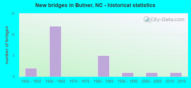
- New bridges - historical statistics
- 21950-1959
- 121960-1969
- 51980-1989
- 11990-1999
- 12000-2009
- 12010-2019


- Bridge Condition - Deck
- 12.5%Very good
- 50.0%Good
- 25.0%Satisfactory
- 12.5%Fair

- Bridge Condition - Superstructure
- 12.5%Very good
- 25.0%Good
- 37.5%Satisfactory
- 25.0%Fair

- Bridge Condition - Substructure
- 25.0%Very good
- 12.5%Good
- 37.5%Satisfactory
- 25.0%Fair

- Bridge Condition - Channel
- 76.9%Good
- 23.1%Satisfactory

- Bridge Condition - Culverts
- 87.5%Satisfactory
- 12.5%Fair
Find on map >> Show street view
Structure Number: 630226, Location: 4.0 MI.S.JCT.NC56 (Lat: 36.069667, Lng: -78.779344), Route carried "on" structure: Interstate 85, Year Built: 1969, Status: Open, Structure Length: 14.17m (46.49ft), Average Daily Traffic: 26,250 (year 2018), Truck Traffic: 23%, Average Future Daily Traffic: 52,500 (year 2040), Design Load: HS 20+Mod, Features Intersected: NEUSE RIVER/FALLS LAKE
Minimum Vertical Clearance: 30+ m (98+ ft), Kilometerpoint: 56.266, Lanes on structure: 2, Base Highway Network: Yes (Inventory Route: 1, Subroute: 85), Owner: State Highway Agency, Approaching Roadway Width: 11.5m (37.7ft), Skew: 12 degrees, Material/Design: Prestressed concrete, Design/Construction: Stringer/Multi-beam, Number Of Spans In Main Unit: 10, Length of Maximum Span: 14.0m (45.9ft), Curb-To-Curb Width: 12.0m (39.4ft), Out-to-Out Width: 12.8m (42.0ft)
Condition: Deck: Satisfactory, Superstructure: Fair, Substructure: Fair, Channel: Good, Operating Rating: 86.1 metric tons, Method Used To Determine Operating Rating: Load Factor (LF), Inventory Rating: 41.7 metric tons, Method Used To Determine Inventory Rating: Load Factor (LF), Structural Evaluation: Somewhat better than minimum adequacy, Deck Geometry: Equal to present minimum criteria, Waterway Adequacy: Equal to present minimum criteria, Approach Roadway Alignment: Equal to present desirable criteria, Designated Inspection Frequency: Every 24 months, Underwater Inspection Frequency: Every 60 months, Inspection Date: Febuary 2022, Underwater Inspection Date: May 2018, Deck Structure Type: Concrete Cast-file-Place, Wearing Surface/Protective System: Wearing Surface: Monolithic Concrete
Find on map >> Show street view
Structure Number: 630227, Location: 4.0 MI S JCT NC56 (Lat: 36.069825, Lng: -78.779436), Route carried "on" structure: Interstate 85, Year Built: 1969, Status: Open, Structure Length: 14.11m (46.29ft), Average Daily Traffic: 26,250 (year 2018), Truck Traffic: 23%, Average Future Daily Traffic: 52,500 (year 2040), Design Load: HS 20+Mod, Features Intersected: NEUSE RIVER/FALLS LAKE
Minimum Vertical Clearance: 30+ m (98+ ft), Kilometerpoint: 56.266, Lanes on structure: 2, Base Highway Network: Yes (Inventory Route: 1, Subroute: 85), Owner: State Highway Agency, Approaching Roadway Width: 11.5m (37.7ft), Skew: 12 degrees, Material/Design: Prestressed concrete, Design/Construction: Stringer/Multi-beam, Number Of Spans In Main Unit: 10, Length of Maximum Span: 14.0m (45.9ft), Curb-To-Curb Width: 12.0m (39.4ft), Out-to-Out Width: 12.8m (42.0ft)
Condition: Deck: Fair, Superstructure: Fair, Substructure: Satisfactory, Channel: Good, Operating Rating: 86.1 metric tons, Method Used To Determine Operating Rating: Load Factor (LF), Inventory Rating: 41.7 metric tons, Method Used To Determine Inventory Rating: Load Factor (LF), Structural Evaluation: Somewhat better than minimum adequacy, Deck Geometry: Equal to present minimum criteria, Waterway Adequacy: Equal to present minimum criteria, Approach Roadway Alignment: Equal to present desirable criteria, Designated Inspection Frequency: Every 24 months, Underwater Inspection Frequency: Every 60 months, Inspection Date: Febuary 2022, Underwater Inspection Date: May 2018, Deck Structure Type: Concrete Cast-file-Place, Wearing Surface/Protective System: Wearing Surface: Monolithic Concrete
Find on map >> Show street view
Structure Number: 770001, Location: 1.0 MI. N. JCT. I85 (Lat: 36.085453, Lng: -78.749842), Route carried "on" structure: US 15, Year Built: 1960, Status: Open, Structure Length: 0.76m (2.49ft), Average Daily Traffic: 9,400 (year 2018), Truck Traffic: 7%, Average Future Daily Traffic: 18,800 (year 2040), Design Load: HS 20+Mod, Features Intersected: BEAVER CREEK
Minimum Vertical Clearance: 30+ m (98+ ft), Kilometerpoint: 0.000, Lanes on structure: 2, Owner: State Highway Agency, Approaching Roadway Width: 6.0m (19.7ft), Material/Design: Concrete continuous, Design/Construction: Culvert, Number Of Spans In Main Unit: 2, Length of Maximum Span: 3.6m (11.8ft)
Condition: Channel: Good, Culverts: Satisfactory, Operating Rating: 41.7 metric tons, Method Used To Determine Operating Rating: Field evaluation and documented engineering judgment, Inventory Rating: 32.6 metric tons, Method Used To Determine Inventory Rating: Field evaluation and documented engineering judgment, Structural Evaluation: Equal to present minimum criteria, Waterway Adequacy: Better than present minimum criteria, Approach Roadway Alignment: Equal to present desirable criteria, Designated Inspection Frequency: Every 24 months, Inspection Date: July 2020
Find on map >> Show street view
Structure Number: 770003, Location: 3.1MI. N. JCT. I85 (Lat: 36.105308, Lng: -78.724908), Route carried "on" structure: US 15, Year Built: 1950, Status: Open, Structure Length: 0.64m (2.10ft), Average Daily Traffic: 6,800 (year 2018), Truck Traffic: 6%, Average Future Daily Traffic: 13,600 (year 2040), Design Load: HS 20, Features Intersected: CREEK
Minimum Vertical Clearance: 30+ m (98+ ft), Kilometerpoint: 0.000, Lanes on structure: 2, Owner: State Highway Agency, Approaching Roadway Width: 6.7m (22.0ft), Material/Design: Concrete continuous, Design/Construction: Culvert, Number Of Spans In Main Unit: 2, Length of Maximum Span: 3.0m (9.8ft)
Condition: Channel: Good, Culverts: Satisfactory, Operating Rating: 41.7 metric tons, Method Used To Determine Operating Rating: Field evaluation and documented engineering judgment, Inventory Rating: 32.6 metric tons, Method Used To Determine Inventory Rating: Field evaluation and documented engineering judgment, Structural Evaluation: Equal to present minimum criteria, Waterway Adequacy: Better than present minimum criteria, Approach Roadway Alignment: Equal to present desirable criteria, Designated Inspection Frequency: Every 24 months, Inspection Date: July 2020
Find on map >> Show street view
Structure Number: 770016, Location: 0.4 MI.S. OF SR1102 (Lat: 36.079933, Lng: -78.766831), Route carried "on" structure: US 15, Year Built: 1969, Status: Open, Structure Length: 9.02m (29.59ft), Average Daily Traffic: 4,300 (year 2018), Truck Traffic: 6%, Average Future Daily Traffic: 8,600 (year 2040), Design Load: HS 20+Mod, Features Intersected: I85
Minimum Vertical Clearance: 30+ m (98+ ft), Kilometerpoint: 0.000, Lanes on structure: 2, Lanes under structure: 5, Owner: State Highway Agency, Approaching Roadway Width: 16.1m (52.8ft), Skew: 3 degrees, Material/Design: Steel, Design/Construction: Stringer/Multi-beam, Number Of Spans In Main Unit: 4, Length of Maximum Span: 29.2m (95.8ft), Curb-To-Curb Width: 16.2m (53.1ft), Out-to-Out Width: 17.0m (55.8ft)
Condition: Deck: Good, Superstructure: Satisfactory, Substructure: Satisfactory, Operating Rating: 75.2 metric tons, Method Used To Determine Operating Rating: Load Factor (LF), Inventory Rating: 45.3 metric tons, Method Used To Determine Inventory Rating: Load Factor (LF), Structural Evaluation: Equal to present minimum criteria, Deck Geometry: Superior to present desirable criteria, Underclear: Somewhat better than minimum adequacy, Approach Roadway Alignment: Equal to present desirable criteria, Designated Inspection Frequency: Every 24 months, Inspection Date: June 2020, Deck Structure Type: Concrete Cast-file-Place, Wearing Surface/Protective System: Wearing Surface: Monolithic Concrete
Find on map >> Show street view
Structure Number: 770043, Location: 0.3 MI.W. SR1102 (Lat: 36.120442, Lng: -78.745778), Route carried "on" structure: State highway 1103, Year Built: 1969, Status: Open, Structure Length: 8.35m (27.40ft), Average Daily Traffic: 15,000 (year 2017), Truck Traffic: 6%, Average Future Daily Traffic: 30,000 (year 2040), Design Load: HS 15, Features Intersected: I85
Minimum Vertical Clearance: 30+ m (98+ ft), Kilometerpoint: 0.000, Lanes on structure: 2, Lanes under structure: 4, Owner: State Highway Agency, Approaching Roadway Width: 7.9m (25.9ft), Skew: 2 degrees, Material/Design: Steel, Design/Construction: Stringer/Multi-beam, Number Of Spans In Main Unit: 4, Length of Maximum Span: 24.6m (80.7ft), Curb-To-Curb Width: 10.1m (33.1ft), Out-to-Out Width: 10.9m (35.8ft)
Condition: Deck: Satisfactory, Superstructure: Satisfactory, Substructure: Satisfactory, Operating Rating: 45.3 metric tons, Method Used To Determine Operating Rating: Load Factor (LF), Inventory Rating: 27.2 metric tons, Method Used To Determine Inventory Rating: Load Factor (LF), Structural Evaluation: Equal to present minimum criteria, Deck Geometry: Meets minimum limits, Underclear: Equal to present minimum criteria, Approach Roadway Alignment: Equal to present desirable criteria, Designated Inspection Frequency: Every 24 months, Inspection Date: June 2020, Deck Structure Type: Concrete Cast-file-Place, Wearing Surface/Protective System: Wearing Surface: Latex Concrete
Find on map >> Show street view
Structure Number: 77005, Location: 0.2 MI.W. OF SR1129 (Lat: 36.171803, Lng: -78.705361), Route carried "on" structure: State highway 1127, Year Built: 1969, Status: Posted for load, Structure Length: 8.53m (27.99ft), Average Daily Traffic: 1,100 (year 2012), Truck Traffic: 7%, Average Future Daily Traffic: 2,200 (year 2040), Design Load: HS 15, Features Intersected: I85
Minimum Vertical Clearance: 30+ m (98+ ft), Kilometerpoint: 0.000, Lanes on structure: 2, Lanes under structure: 4, Owner: State Highway Agency, Approaching Roadway Width: 7.3m (24.0ft), Skew: 2 degrees, Material/Design: Steel, Design/Construction: Stringer/Multi-beam, Number Of Spans In Main Unit: 4, Length of Maximum Span: 24.9m (81.7ft), Curb-To-Curb Width: 10.3m (33.8ft), Out-to-Out Width: 10.9m (35.8ft)
Condition: Deck: Good, Superstructure: Satisfactory, Substructure: Fair, Operating Rating: 33.5 metric tons, Method Used To Determine Operating Rating: Load Factor (LF), Inventory Rating: 19.9 metric tons, Method Used To Determine Inventory Rating: Load Factor (LF), Structural Evaluation: Somewhat better than minimum adequacy, Deck Geometry: Somewhat better than minimum adequacy, Underclear: Equal to present minimum criteria, Approach Roadway Alignment: Equal to present desirable criteria, Bridge Posting: Required (Relationship of Operating Rating to Maximum Legal Load: 20.0 - 29.9% below), Designated Inspection Frequency: Every 24 months, Inspection Date: June 2020, Deck Structure Type: Concrete Cast-file-Place
Find on map >> Show street view
Structure Number: 770062, Location: 1.3 MILES N. JCT. SR1120 (Lat: 36.155708, Lng: -78.773642), Route carried "on" structure: State highway 1004, Year Built: 2017, Status: Open, Structure Length: 4.17m (13.68ft), Average Daily Traffic: 4,300 (year 2017), Truck Traffic: 7%, Average Future Daily Traffic: 8,600 (year 2040), Design Load: HL 93, Features Intersected: KNAP OF REEDS CREEK
Minimum Vertical Clearance: 30+ m (98+ ft), Kilometerpoint: 0.000, Lanes on structure: 2, Owner: State Highway Agency, Approaching Roadway Width: 9.4m (30.8ft), Material/Design: Prestressed concrete, Design/Construction: Slab, Number Of Spans In Main Unit: 3, Number Of Approach Spans: 2, Length of Maximum Span: 21.0m (68.9ft), Curb-To-Curb Width: 9.1m (29.9ft), Out-to-Out Width: 10.0m (32.8ft)
Condition: Deck: Very good, Superstructure: Very good, Substructure: Very good, Channel: Satisfactory, Operating Rating: 50.8 metric tons, Method Used To Determine Operating Rating: Load and Resistance Factor (LRFR), Inventory Rating: 39.0 metric tons, Method Used To Determine Inventory Rating: Load and Resistance Factor (LRFR), Structural Evaluation: Equal to present desirable criteria, Deck Geometry: Meets minimum limits, Waterway Adequacy: Better than present minimum criteria, Approach Roadway Alignment: Equal to present desirable criteria, Designated Inspection Frequency: Every 24 months, Inspection Date: January 2022, Deck Structure Type: Concrete Precast Panels, Wearing Surface/Protective System: Wearing Surface: Bituminous, Deck Protection: Epoxy Coated Reinforcing
Find on map >> Show street view
Structure Number: 770206, Location: 0.23 MI S.OF JCT SR1127 (Lat: 36.176108, Lng: -78.714006), Route carried "on" structure: State highway 1215, Year Built: 1989, Status: Open, Structure Length: 0.64m (2.10ft), Average Daily Traffic: 5,600 (year 2017), Truck Traffic: 6%, Average Future Daily Traffic: 11,200 (year 2040), Design Load: HS 20+Mod, Features Intersected: LEDGE CREEK
Minimum Vertical Clearance: 30+ m (98+ ft), Kilometerpoint: 0.000, Lanes on structure: 2, Owner: State Highway Agency, Approaching Roadway Width: 6.7m (22.0ft), Material/Design: Steel, Design/Construction: Culvert, Number Of Spans In Main Unit: 2, Length of Maximum Span: 2.7m (8.9ft)
Condition: Channel: Satisfactory, Culverts: Satisfactory, Operating Rating: 89.8 metric tons, Method Used To Determine Operating Rating: Load and Resistance Factor (LRFR), Inventory Rating: 76.2 metric tons, Method Used To Determine Inventory Rating: Load and Resistance Factor (LRFR), Structural Evaluation: Equal to present minimum criteria, Waterway Adequacy: Equal to present minimum criteria, Approach Roadway Alignment: Equal to present desirable criteria, Designated Inspection Frequency: Every 24 months, Inspection Date: July 2020
Find on map >> Show street view
Structure Number: 770207, Location: 0.1MI.N. JCT SR1104 (Lat: 36.157792, Lng: -78.774306), Route carried "on" structure: State highway 1121, Year Built: 1995, Status: Open, Structure Length: 4.11m (13.48ft), Average Daily Traffic: 1,100 (year 2006), Truck Traffic: 6%, Average Future Daily Traffic: 2,200 (year 2040), Design Load: HS 20+Mod, Features Intersected: KNAPP OF REEDS CREEK
Minimum Vertical Clearance: 30+ m (98+ ft), Kilometerpoint: 0.000, Lanes on structure: 2, Owner: State Highway Agency, Approaching Roadway Width: 7.3m (24.0ft), Material/Design: Prestressed concrete, Design/Construction: Slab, Number Of Spans In Main Unit: 3, Length of Maximum Span: 13.4m (44.0ft), Curb-To-Curb Width: 8.2m (26.9ft), Out-to-Out Width: 9.1m (29.9ft)
Condition: Deck: Good, Superstructure: Good, Substructure: Good, Channel: Good, Operating Rating: 78.0 metric tons, Method Used To Determine Operating Rating: Load Factor (LF), Inventory Rating: 46.2 metric tons, Method Used To Determine Inventory Rating: Load Factor (LF), Structural Evaluation: Better than present minimum criteria, Deck Geometry: Meets minimum limits, Waterway Adequacy: Better than present minimum criteria, Approach Roadway Alignment: Equal to present desirable criteria, Designated Inspection Frequency: Every 24 months, Inspection Date: May 2020, Deck Structure Type: Concrete Precast Panels, Wearing Surface/Protective System: Wearing Surface: Bituminous
Find on map >> Show street view
Structure Number: 770226, Location: 0.1 MI E JCT SR1104 (Lat: 36.143278, Lng: -78.788444), Route carried "on" structure: State highway 1120, Year Built: 2005, Status: Open, Structure Length: 5.30m (17.39ft), Average Daily Traffic: 5,100 (year 2017), Truck Traffic: 7%, Average Future Daily Traffic: 10,200 (year 2040), Design Load: HS 20+Mod, Features Intersected: KNAP OF REEDS CREEK
Minimum Vertical Clearance: 30+ m (98+ ft), Kilometerpoint: 0.000, Lanes on structure: 2, Owner: State Highway Agency, Approaching Roadway Width: 10.0m (32.8ft), Skew: 4 degrees, Material/Design: Prestressed concrete, Design/Construction: Slab, Number Of Spans In Main Unit: 3, Length of Maximum Span: 17.3m (56.8ft), Curb-To-Curb Width: 10.9m (35.8ft), Out-to-Out Width: 11.8m (38.7ft)
Condition: Deck: Good, Superstructure: Good, Substructure: Very good, Channel: Good, Operating Rating: 60.7 metric tons, Method Used To Determine Operating Rating: Load Factor (LF), Inventory Rating: 36.2 metric tons, Method Used To Determine Inventory Rating: Load Factor (LF), Structural Evaluation: Better than present minimum criteria, Deck Geometry: Meets minimum limits, Waterway Adequacy: Better than present minimum criteria, Approach Roadway Alignment: Equal to present desirable criteria, Designated Inspection Frequency: Every 24 months, Inspection Date: May 2020, Deck Structure Type: Concrete Precast Panels, Wearing Surface/Protective System: Wearing Surface: Bituminous
Find on map >> Show street view
Structure Number: 770258, Location: 0.3MI E.SR1004 (Lat: 36.156964, Lng: -78.745600), Route carried "on" structure: State highway 1112, Year Built: 1989, Status: Open, Structure Length: 0.70m (2.30ft), Average Daily Traffic: 3,700 (year 2013), Truck Traffic: 6%, Average Future Daily Traffic: 7,400 (year 2040), Design Load: HS 20+Mod, Features Intersected: PICTURE CREEK
Minimum Vertical Clearance: 30+ m (98+ ft), Kilometerpoint: 0.000, Lanes on structure: 2, Owner: State Highway Agency, Approaching Roadway Width: 6.7m (22.0ft), Material/Design: Steel, Design/Construction: Culvert, Number Of Spans In Main Unit: 2, Length of Maximum Span: 3.0m (9.8ft)
Condition: Channel: Good, Culverts: Fair, Operating Rating: 89.8 metric tons, Method Used To Determine Operating Rating: Load and Resistance Factor (LRFR), Inventory Rating: 89.8 metric tons, Method Used To Determine Inventory Rating: Load and Resistance Factor (LRFR), Structural Evaluation: Somewhat better than minimum adequacy, Waterway Adequacy: Better than present minimum criteria, Approach Roadway Alignment: Equal to present desirable criteria, Designated Inspection Frequency: Every 24 months, Inspection Date: September 2020
Find on map >> Show street view
Structure Number: 770263, Location: 0.2 MI E JCT US15 (Lat: 36.084308, Lng: -78.748914), Route carried "on" structure: State highway 1724, Year Built: 1950, Status: Open, Structure Length: 0.76m (2.49ft), Average Daily Traffic: 440 (year 2013), Truck Traffic: 6%, Average Future Daily Traffic: 880 (year 2040), Design Load: HS 20, Features Intersected: CREEK
Minimum Vertical Clearance: 30+ m (98+ ft), Kilometerpoint: 0.000, Lanes on structure: 2, Owner: State Highway Agency, Approaching Roadway Width: 5.4m (17.7ft), Material/Design: Concrete continuous, Design/Construction: Culvert, Number Of Spans In Main Unit: 2, Length of Maximum Span: 3.6m (11.8ft)
Condition: Channel: Satisfactory, Culverts: Satisfactory, Operating Rating: 41.7 metric tons, Method Used To Determine Operating Rating: Field evaluation and documented engineering judgment, Inventory Rating: 32.6 metric tons, Method Used To Determine Inventory Rating: Field evaluation and documented engineering judgment, Structural Evaluation: Equal to present minimum criteria, Waterway Adequacy: Better than present minimum criteria, Approach Roadway Alignment: Equal to present desirable criteria, Designated Inspection Frequency: Every 24 months, Underwater Inspection Frequency: Every 60 months, Inspection Date: August 2020, Underwater Inspection Date: August 2020
Find on map >> Show street view
Structure Number: 770265, Location: 0.5 MI.S. JCT.SR1112 (Lat: 36.151728, Lng: -78.767711), Route carried "on" structure: State highway 1239, Year Built: 1984, Status: Open, Structure Length: 0.97m (3.18ft), Average Daily Traffic: 3,400 (year 2017), Truck Traffic: 7%, Average Future Daily Traffic: 6,800 (year 2040), Design Load: HS 20+Mod, Features Intersected: PICTURE CREEK
Minimum Vertical Clearance: 30+ m (98+ ft), Kilometerpoint: 0.000, Lanes on structure: 2, Owner: State Highway Agency, Approaching Roadway Width: 7.0m (23.0ft), Material/Design: Steel, Design/Construction: Culvert, Number Of Spans In Main Unit: 3, Length of Maximum Span: 2.7m (8.9ft)
Condition: Channel: Good, Culverts: Satisfactory, Operating Rating: 89.8 metric tons, Method Used To Determine Operating Rating: Load and Resistance Factor (LRFR), Inventory Rating: 89.8 metric tons, Method Used To Determine Inventory Rating: Load and Resistance Factor (LRFR), Structural Evaluation: Equal to present minimum criteria, Waterway Adequacy: Better than present minimum criteria, Approach Roadway Alignment: Equal to present desirable criteria, Designated Inspection Frequency: Every 24 months, Inspection Date: July 2020
Find on map >> Show street view
Structure Number: 1830087, Location: 1.5 MI W NC50 (Lat: 36.075575, Lng: -78.720722), Route carried "on" structure: State highway 1901, Year Built: 1980, Status: Open, Structure Length: 0.73m (2.40ft), Average Daily Traffic: 6,200 (year 2015), Truck Traffic: 6%, Average Future Daily Traffic: 12,400 (year 2040), Design Load: HS 20+Mod, Features Intersected: LEDGE CREEK
Minimum Vertical Clearance: 30+ m (98+ ft), Kilometerpoint: 0.000, Lanes on structure: 2, Owner: State Highway Agency, Approaching Roadway Width: 8.2m (26.9ft), Skew: 4 degrees, Material/Design: Concrete continuous, Design/Construction: Culvert, Number Of Spans In Main Unit: 2, Length of Maximum Span: 2.4m (7.9ft)
Condition: Channel: Good, Culverts: Satisfactory, Operating Rating: 53.5 metric tons, Method Used To Determine Operating Rating: Load and Resistance Factor (LRFR), Inventory Rating: 40.8 metric tons, Method Used To Determine Inventory Rating: Load and Resistance Factor (LRFR), Structural Evaluation: Equal to present minimum criteria, Waterway Adequacy: Better than present minimum criteria, Approach Roadway Alignment: Equal to present desirable criteria, Designated Inspection Frequency: Every 24 months, Underwater Inspection Frequency: Every 60 months, Inspection Date: August 2021, Underwater Inspection Date: August 2021
Find on map >> Show street view
Structure Number: 1830088, Location: 1.0 MI W. OF NC50 (Lat: 36.076394, Lng: -78.707531), Route carried "on" structure: State highway 1901, Year Built: 1980, Status: Open, Structure Length: 1.98m (6.50ft), Average Daily Traffic: 6,200 (year 2015), Truck Traffic: 6%, Average Future Daily Traffic: 12,400 (year 2040), Design Load: HS 20+Mod, Features Intersected: LEDGE CREEK
Minimum Vertical Clearance: 30+ m (98+ ft), Kilometerpoint: 0.000, Lanes on structure: 2, Owner: State Highway Agency, Approaching Roadway Width: 14.0m (45.9ft), Skew: 4 degrees, Material/Design: Concrete continuous, Design/Construction: Culvert, Number Of Spans In Main Unit: 4, Length of Maximum Span: 3.3m (10.8ft)
Condition: Channel: Good, Culverts: Satisfactory, Operating Rating: 70.7 metric tons, Method Used To Determine Operating Rating: Load and Resistance Factor (LRFR), Inventory Rating: 54.4 metric tons, Method Used To Determine Inventory Rating: Load and Resistance Factor (LRFR), Structural Evaluation: Equal to present minimum criteria, Waterway Adequacy: Better than present minimum criteria, Approach Roadway Alignment: Equal to present desirable criteria, Designated Inspection Frequency: Every 24 months, Underwater Inspection Frequency: Every 60 months, Inspection Date: January 2021, Underwater Inspection Date: January 2021
Find on map >> Show street view
Structure Number: 770016, Location: 0.4 MI.S. OF SR1102 (Lat: 36.079933, Lng: -78.766831), Route carried "under" structure: Interstate 85, Year Built: 1969, Structure Length: 0. m, Average Daily Traffic: 17,500 (year 2013), Truck Traffic: 16%, Features Intersected: US15
Minimum Vertical Clearance: 5.81m (19.06ft), Kilometerpoint: 0.000, Lanes on structure: 2, Lanes under structure: 2, Material/Design: Steel, Design/Construction: Stringer/Multi-beam, Length of Maximum Span: 29.2m (95.8ft)
Find on map >> Show street view
Structure Number: 770016, Location: 0.4 MI.S. OF SR1102 (Lat: 36.079933, Lng: -78.766831), Route carried "under" structure: Interstate 85, Year Built: 1969, Structure Length: 0. m, Average Daily Traffic: 17,500 (year 2013), Truck Traffic: 16%, Features Intersected: US15
Minimum Vertical Clearance: 5.35m (17.55ft), Kilometerpoint: 0.000, Lanes on structure: 2, Lanes under structure: 3, Material/Design: Steel, Design/Construction: Stringer/Multi-beam, Length of Maximum Span: 29.2m (95.8ft)
Find on map >> Show street view
Structure Number: 770043, Location: 0.3 MI.W. SR1102 (Lat: 36.120442, Lng: -78.745778), Route carried "under" structure: Interstate 85, Year Built: 1969, Structure Length: 0. m, Average Daily Traffic: 16,000 (year 2013), Truck Traffic: 16%, Features Intersected: SR1103
Minimum Vertical Clearance: 5.05m (16.57ft), Kilometerpoint: 57.485, Lanes on structure: 2, Lanes under structure: 2, Material/Design: Steel, Design/Construction: Stringer/Multi-beam, Length of Maximum Span: 24.6m (80.7ft)
Find on map >> Show street view
Structure Number: 770043, Location: 0.3 MI.W. SR1102 (Lat: 36.120442, Lng: -78.745778), Route carried "under" structure: Interstate 85, Year Built: 1969, Structure Length: 0. m, Average Daily Traffic: 16,000 (year 2013), Truck Traffic: 16%, Features Intersected: SR1103
Minimum Vertical Clearance: 5.46m (17.91ft), Kilometerpoint: 57.485, Lanes on structure: 2, Lanes under structure: 2, Material/Design: Steel, Design/Construction: Stringer/Multi-beam, Length of Maximum Span: 24.6m (80.7ft)
Find on map >> Show street view
Structure Number: 77005, Location: 0.2 MI.W. OF SR1129 (Lat: 36.171803, Lng: -78.705361), Route carried "under" structure: Interstate 85, Year Built: 1969, Structure Length: 0. m, Average Daily Traffic: 16,000 (year 2013), Truck Traffic: 23%, Features Intersected: SR1127
Minimum Vertical Clearance: 6.17m (20.24ft), Kilometerpoint: 5882.711, Lanes on structure: 2, Lanes under structure: 2, Material/Design: Steel, Design/Construction: Stringer/Multi-beam, Length of Maximum Span: 24.9m (81.7ft)
Find on map >> Show street view
Structure Number: 77005, Location: 0.2 MI.W. OF SR1129 (Lat: 36.171803, Lng: -78.705361), Route carried "under" structure: Interstate 85, Year Built: 1969, Structure Length: 0. m, Average Daily Traffic: 16,000 (year 2013), Truck Traffic: 23%, Features Intersected: SR1127
Minimum Vertical Clearance: 5.48m (17.98ft), Kilometerpoint: 5882.711, Lanes on structure: 2, Lanes under structure: 2, Material/Design: Steel, Design/Construction: Stringer/Multi-beam, Length of Maximum Span: 24.9m (81.7ft)