Bridge Statistics for Bedford, Massachusetts (MA)
Condition, Traffic, Stress, Structural Evaluation, Project Costs
- National Bridge Inventory (NBI) Statistics
- 11Number of bridges
- 105ft / 32.4mTotal length
- $13,485,000Total costs
- 275,932Total average daily traffic
- 23,606Total average daily truck traffic
- 455,513Total future (year 2031) average daily traffic
- National Bridge Inventory (NBI) Registered Bridges for Bedford
- No street view available for this location
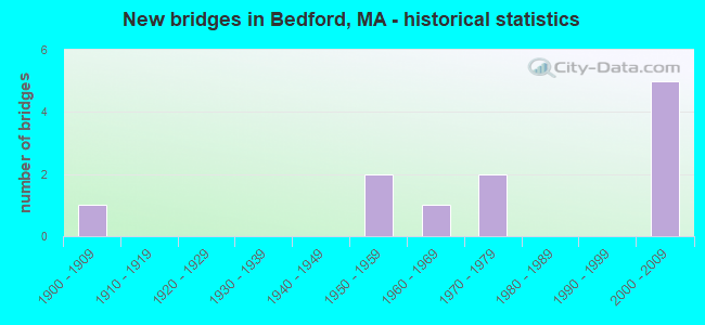
- New bridges - historical statistics
- 11900-1909
- 21950-1959
- 11960-1969
- 21970-1979
- 52000-2009


- Bridge Condition - Deck
- 11.1%Very good
- 55.6%Good
- 22.2%Satisfactory
- 11.1%Fair

- Bridge Condition - Superstructure
- 11.1%Very good
- 44.4%Good
- 33.3%Satisfactory
- 11.1%Fair

- Bridge Condition - Substructure
- 55.6%Good
- 11.1%Satisfactory
- 33.3%Fair

- Bridge Condition - Channel
- 12.5%Very good
- 25.0%Good
- 25.0%Satisfactory
- 25.0%Fair
- 12.5%Poor

- Bridge Condition - Culverts
- 50.0%Fair
- 50.0%Poor
Find on map >> Show street view
Structure Number: B040012K5DOTNBI, Location: 1.25 MI NW RT 128 & BDFRD (Lat: 42.486272, Lng: -71.261733), Route carried "on" structure: State highway 225, Year Built: 1903, Year Reconstructed: 2020, Status: Posted for load, Structure Length: 1.04m (3.41ft), Average Daily Traffic: 37,000 (year 2020), Truck Traffic: 10%, Average Future Daily Traffic: 67,436 (year 2031), Design Load: HS 20, Features Intersected: WATER SHAWSHEEN RIVER, Facility Carried by Structure: ST 4 GREAT RD
Minimum Vertical Clearance: 30+ m (98+ ft), Kilometerpoint: 9.382, Lanes on structure: 2, Owner: State Highway Agency, Approaching Roadway Width: 11.0m (36.1ft), Material/Design: Concrete, Design/Construction: Slab, Number Of Spans In Main Unit: 1, Length of Maximum Span: 8.8m (28.9ft), Curb or Sidewalk Widths: Left: 0.0m, Right: 1.8m (5.9ft), Curb-To-Curb Width: 11.1m (36.4ft), Out-to-Out Width: 14.3m (46.9ft)
Condition: Deck: Good, Superstructure: Good, Substructure: Fair, Channel: Fair, Operating Rating: 29.2 metric tons, Method Used To Determine Operating Rating: Load and Resistance Factor Rating (LRFR) rating reported by rating factor(RF) method using HL-93 loadings, Inventory Rating: 22.7 metric tons, Method Used To Determine Inventory Rating: Load and Resistance Factor Rating (LRFR) rating reported by rating factor(RF) method using HL-93 loadings, Structural Evaluation: Somewhat better than minimum adequacy, Deck Geometry: Meets minimum limits, Waterway Adequacy: Better than present minimum criteria, Approach Roadway Alignment: Better than present minimum criteria, Bridge Posting: Required (Relationship of Operating Rating to Maximum Legal Load: 10.0 - 19.9% below), Designated Inspection Frequency: Every 24 months, Inspection Date: July 2020, Deck Structure Type: Concrete Cast-file-Place, Wearing Surface/Protective System: Wearing Surface: Integral Concrete
Find on map >> Show street view
Structure Number: B040022K4DOTNBI, Location: AT TWNLN BEDFORD-CARLISLE (Lat: 42.509078, Lng: -71.314069), Route carried "on" structure: State highway 225, Year Built: 1955, Status: Posted for load, Structure Length: 5.79m (19.00ft), Average Daily Traffic: 9,750 (year 2019), Truck Traffic: 2%, Average Future Daily Traffic: 15,521 (year 2032), Design Load: H 20, Features Intersected: WATER CONCORD RIVER
Minimum Vertical Clearance: 30+ m (98+ ft), Kilometerpoint: 35.340, Lanes on structure: 2, Owner: State Highway Agency, Approaching Roadway Width: 9.1m (29.9ft), Material/Design: Concrete continuous, Design/Construction: Slab, Number Of Spans In Main Unit: 10, Length of Maximum Span: 6.1m (20.0ft), Curb or Sidewalk Widths: Left: 0.9m (3.0ft), Right: 0.9m (3.0ft), Curb-To-Curb Width: 9.1m (29.9ft), Out-to-Out Width: 11.8m (38.7ft)
Condition: Deck: Fair, Superstructure: Fair, Substructure: Fair, Channel: Fair, Operating Rating: 39.6 metric tons, Method Used To Determine Operating Rating: Load Factor (LF), Inventory Rating: 23.7 metric tons, Method Used To Determine Inventory Rating: Load Factor (LF), Structural Evaluation: Somewhat better than minimum adequacy, Deck Geometry: High priority of corrective action, Waterway Adequacy: Equal to present desirable criteria, Approach Roadway Alignment: Equal to present desirable criteria, Length Of Structure Improvement: 5.80m (19.03ft), Designated Inspection Frequency: Every 24 months, Underwater Inspection Frequency: Every 36 months, Inspection Date: October 2021, Underwater Inspection Date: April 2021, Bridge Improvement Cost: $2,689,000, Roadway Improvement Cost: $269,000, Total Project Cost: $4,034,000 ( Estimate for 2022), Deck Structure Type: Concrete Cast-file-Place, Wearing Surface/Protective System: Wearing Surface: Bituminous
Find on map >> Show street view
Structure Number: B040032B4MUNNBI, Location: .8 MI W OF RTE 3 (Lat: 42.498017, Lng: -71.256164), Route carried "on" structure: City street , Year Built: 1962, Status: Open, Structure Length: 1.07m (3.51ft), Average Daily Traffic: 17,100 (year 2018), Truck Traffic: 8%, Average Future Daily Traffic: 25,111 (year 2033), Design Load: H 20, Features Intersected: WATER SHAWSHEEN RIVER, Facility Carried by Structure: ST 62 BURLINGTN RD
Minimum Vertical Clearance: 30+ m (98+ ft), Kilometerpoint: 6.823, Lanes on structure: 2, Owner: Town or Township Highway Agency, Approaching Roadway Width: 9.1m (29.9ft), Skew: 2 degrees, Material/Design: Prestressed concrete, Design/Construction: Slab, Number Of Spans In Main Unit: 1, Length of Maximum Span: 10.1m (33.1ft), Curb or Sidewalk Widths: Left: 0.3m (1.0ft), Right: 1.5m (4.9ft), Curb-To-Curb Width: 9.1m (29.9ft), Out-to-Out Width: 11.0m (36.1ft)
Condition: Deck: Satisfactory, Superstructure: Satisfactory, Substructure: Satisfactory, Channel: Good, Operating Rating: 53.1 metric tons, Method Used To Determine Operating Rating: Load Factor (LF), Inventory Rating: 47.6 metric tons, Method Used To Determine Inventory Rating: Load Factor (LF), Structural Evaluation: Equal to present minimum criteria, Deck Geometry: High priority of corrective action, Waterway Adequacy: Better than present minimum criteria, Approach Roadway Alignment: Somewhat better than minimum adequacy, Length Of Structure Improvement: 1.10m (3.61ft), Designated Inspection Frequency: Every 24 months, Inspection Date: March 2022, Bridge Improvement Cost: $446,000, Roadway Improvement Cost: $45,000, Total Project Cost: $670,000 ( Estimate for 2022), Deck Structure Type: Concrete Precast Panels, Wearing Surface/Protective System: Wearing Surface: Bituminous, Membrane: Built-up
Find on map >> Show street view
Structure Number: B040062B5MUNNBI, Location: .7 M SE OF BILLERICA (Lat: 42.517872, Lng: -71.245147), Route carried "on" structure: City street , Year Built: 1975, Status: Open, Structure Length: 1.16m (3.81ft), Average Daily Traffic: 18,000 (year 2018), Truck Traffic: 8%, Average Future Daily Traffic: 26,374 (year 2033), Features Intersected: WATER SHAWSHEEN RIVER, Facility Carried by Structure: HWY MDDLSEX TPK
Minimum Vertical Clearance: 30+ m (98+ ft), Kilometerpoint: 1.368, Lanes on structure: 2, Owner: Town or Township Highway Agency, Approaching Roadway Width: 9.1m (29.9ft), Material/Design: Steel, Design/Construction: Culvert, Number Of Spans In Main Unit: 2, Length of Maximum Span: 5.2m (17.1ft), Curb or Sidewalk Widths: Left: 1.1m (3.6ft), Right: 1.1m (3.6ft), Curb-To-Curb Width: 9.1m (29.9ft), Out-to-Out Width: 12.2m (40.0ft)
Condition: Channel: Satisfactory, Culverts: Fair, Structural Evaluation: Somewhat better than minimum adequacy, Deck Geometry: High priority of corrective action, Waterway Adequacy: Better than present minimum criteria, Approach Roadway Alignment: Equal to present desirable criteria, Length Of Structure Improvement: 1.00m (3.28ft), Designated Inspection Frequency: Every 24 months, Inspection Date: March 2022, Bridge Improvement Cost: $456,000, Roadway Improvement Cost: $46,000, Total Project Cost: $685,000 ( Estimate for 2022)
Find on map >> Show street view
Structure Number: B04008B3FMUNNBI, Location: .1MI E OF RT 62 (Lat: 42.492958, Lng: -71.256756), Route carried "on" structure: City street , Year Built: 2009, Status: Open, Structure Length: 1.15m (3.77ft), Average Daily Traffic: 9,900 (year 2017), Truck Traffic: 9%, Average Future Daily Traffic: 17,214 (year 2032), Design Load: HS 20, Features Intersected: WATER SHAWSHEEN RIVER, Facility Carried by Structure: HWY PAGE RD
Minimum Vertical Clearance: 30+ m (98+ ft), Kilometerpoint: 1.722, Lanes on structure: 2, Owner: Town or Township Highway Agency, Approaching Roadway Width: 7.3m (24.0ft), Skew: 1 degrees, Material/Design: Prestressed concrete, Design/Construction: Box Beam or Girders - Single/Spread, Number Of Spans In Main Unit: 1, Length of Maximum Span: 10.5m (34.4ft), Curb or Sidewalk Widths: Left: 1.5m (4.9ft), Right: 1.5m (4.9ft), Curb-To-Curb Width: 7.3m (24.0ft), Out-to-Out Width: 11.3m (37.1ft)
Condition: Deck: Very good, Superstructure: Very good, Substructure: Good, Channel: Very good, Operating Rating: 63.5 metric tons, Method Used To Determine Operating Rating: Load Factor (LF), Inventory Rating: 48.0 metric tons, Method Used To Determine Inventory Rating: Load Factor (LF), Structural Evaluation: Better than present minimum criteria, Deck Geometry: High priority of replacement, Waterway Adequacy: Equal to present desirable criteria, Approach Roadway Alignment: Equal to present desirable criteria, Length Of Structure Improvement: 1.20m (3.94ft), Designated Inspection Frequency: Every 24 months, Inspection Date: December 2021, Bridge Improvement Cost: $689,000, Roadway Improvement Cost: $69,000, Total Project Cost: $1,034,000 ( Estimate for 2022), Deck Structure Type: Concrete Cast-file-Place, Wearing Surface/Protective System: Wearing Surface: Bituminous, Membrane: Preformed Fabric, Deck Protection: Epoxy Coated Reinforcing
Find on map >> Show street view
Structure Number: B040102B7MUNNBI, Location: .6 MI S OF RT 4 & 225 (Lat: 42.484717, Lng: -71.277139), Route carried "on" structure: City street , Year Built: 1970, Status: Posted for load, Structure Length: 0.67m (2.20ft), Average Daily Traffic: 3,400 (year 2018), Truck Traffic: 6%, Average Future Daily Traffic: 6,791 (year 2033), Features Intersected: WATER ELM BROOK, Facility Carried by Structure: HWY SOUTH RD
Minimum Vertical Clearance: 30+ m (98+ ft), Kilometerpoint: 2.317, Lanes on structure: 2, Owner: Town or Township Highway Agency, Approaching Roadway Width: 9.4m (30.8ft), Material/Design: Concrete, Design/Construction: Culvert, Number Of Spans In Main Unit: 2, Length of Maximum Span: 3.0m (9.8ft), Curb or Sidewalk Widths: Left: 1.4m (4.6ft), Right: 2.2m (7.2ft), Curb-To-Curb Width: 9.4m (30.8ft), Out-to-Out Width: 15.7m (51.5ft)
Condition: Channel: Satisfactory, Culverts: Poor, Operating Rating: 10.4 metric tons, Method Used To Determine Operating Rating: Load Factor (LF), Inventory Rating: 6.5 metric tons, Method Used To Determine Inventory Rating: Load Factor (LF), Structural Evaluation: High priority of replacement, Deck Geometry: Meets minimum limits, Waterway Adequacy: Better than present minimum criteria, Approach Roadway Alignment: Better than present minimum criteria, Bridge Posting: Required (Relationship of Operating Rating to Maximum Legal Load: > 39.9% below), Length Of Structure Improvement: 1.70m (5.58ft), Designated Inspection Frequency: Every 12 months, Other Special Inspection Frequency: Every 12 months, Inspection Date: Febuary 2022, Other Special Inspection Date: Febuary 2022, Bridge Improvement Cost: $716,000, Roadway Improvement Cost: $72,000, Total Project Cost: $1,075,000 ( Estimate for 2022)
Find on map >> Show street view
Structure Number: B04011AY9DOTNBI, Location: RT 3 AT RT 62 (Lat: 42.502036, Lng: -71.243517), Route carried "on" structure: US 3, Year Built: 2004, Status: Open, Structure Length: 4.03m (13.22ft), Average Daily Traffic: 38,322 (year 2018), Truck Traffic: 10%, Average Future Daily Traffic: 94,758 (year 2032), Design Load: HS 25 or greater, Features Intersected: ST 62 BURLINGTON RD
Minimum Vertical Clearance: 30+ m (98+ ft), Kilometerpoint: 117.060, Lanes on structure: 4, Lanes under structure: 4, Base Highway Network: Yes, Owner: State Highway Agency, Approaching Roadway Width: 23.4m (76.8ft), Skew: 2 degrees, Material/Design: Steel, Design/Construction: Stringer/Multi-beam, Number Of Spans In Main Unit: 1, Length of Maximum Span: 38.2m (125.3ft), Curb-To-Curb Width: 23.4m (76.8ft), Out-to-Out Width: 24.5m (80.4ft)
Condition: Deck: Good, Superstructure: Good, Substructure: Good, Operating Rating: 94.0 metric tons, Method Used To Determine Operating Rating: Load Factor (LF), Inventory Rating: 56.3 metric tons, Method Used To Determine Inventory Rating: Load Factor (LF), Structural Evaluation: Better than present minimum criteria, Deck Geometry: Superior to present desirable criteria, Underclear: High priority of corrective action, Approach Roadway Alignment: Equal to present desirable criteria, Length Of Structure Improvement: 4.10m (13.45ft), Designated Inspection Frequency: Every 24 months, Inspection Date: May 2021, Bridge Improvement Cost: $395,000, Roadway Improvement Cost: $40,000, Total Project Cost: $593,000 ( Estimate for 2022), Deck Structure Type: Concrete Cast-file-Place, Wearing Surface/Protective System: Wearing Surface: Monolithic Concrete, Deck Protection: Epoxy Coated Reinforcing
Find on map >> Show street view
Structure Number: B04011AYADOTNBI, Location: RT 3 AT RT 62 (Lat: 42.502117, Lng: -71.243086), Route carried "on" structure: US 3, Year Built: 2004, Status: Open, Structure Length: 4.03m (13.22ft), Average Daily Traffic: 51,663 (year 2018), Truck Traffic: 10%, Average Future Daily Traffic: 94,758 (year 2032), Design Load: HS 25 or greater, Features Intersected: ST 62 BURLINGTON RD
Minimum Vertical Clearance: 30+ m (98+ ft), Kilometerpoint: 117.060, Lanes on structure: 4, Lanes under structure: 4, Base Highway Network: Yes, Owner: State Highway Agency, Approaching Roadway Width: 23.9m (78.4ft), Skew: 22 degrees, Material/Design: Steel, Design/Construction: Stringer/Multi-beam, Number Of Spans In Main Unit: 1, Length of Maximum Span: 38.2m (125.3ft), Curb-To-Curb Width: 24.0m (78.7ft), Out-to-Out Width: 25.0m (82.0ft)
Condition: Deck: Good, Superstructure: Good, Substructure: Good, Operating Rating: 94.9 metric tons, Method Used To Determine Operating Rating: Load Factor (LF), Inventory Rating: 56.9 metric tons, Method Used To Determine Inventory Rating: Load Factor (LF), Structural Evaluation: Better than present minimum criteria, Deck Geometry: Superior to present desirable criteria, Underclear: High priority of corrective action, Approach Roadway Alignment: Equal to present desirable criteria, Length Of Structure Improvement: 4.10m (13.45ft), Designated Inspection Frequency: Every 24 months, Inspection Date: May 2021, Bridge Improvement Cost: $404,000, Roadway Improvement Cost: $41,000, Total Project Cost: $607,000 ( Estimate for 2022), Deck Structure Type: Concrete Cast-file-Place, Wearing Surface/Protective System: Wearing Surface: Monolithic Concrete, Deck Protection: Epoxy Coated Reinforcing
Find on map >> Show street view
Structure Number: B04012737DOTNBI, Location: 0.5 MI NW RT 62 & RT 3 (Lat: 42.547847, Lng: -71.287639), Route carried "on" structure: US 3, Year Built: 2004, Status: Open, Structure Length: 3.04m (9.97ft), Average Daily Traffic: 60,000 (year 2019), Truck Traffic: 10%, Average Future Daily Traffic: 94,758 (year 2032), Design Load: HS 25 or greater, Features Intersected: WATER SHAWSHEEN RIVER
Minimum Vertical Clearance: 30+ m (98+ ft), Kilometerpoint: 118.070, Lanes on structure: 3, Base Highway Network: Yes, Owner: State Highway Agency, Approaching Roadway Width: 22.8m (74.8ft), Skew: 4 degrees, Material/Design: Steel, Design/Construction: Stringer/Multi-beam, Number Of Spans In Main Unit: 1, Length of Maximum Span: 29.1m (95.5ft), Curb-To-Curb Width: 22.8m (74.8ft), Out-to-Out Width: 23.8m (78.1ft)
Condition: Deck: Good, Superstructure: Good, Substructure: Good, Channel: Good, Operating Rating: 96.1 metric tons, Method Used To Determine Operating Rating: Load Factor (LF), Inventory Rating: 57.5 metric tons, Method Used To Determine Inventory Rating: Load Factor (LF), Structural Evaluation: Better than present minimum criteria, Deck Geometry: Superior to present desirable criteria, Waterway Adequacy: Equal to present desirable criteria, Approach Roadway Alignment: Equal to present desirable criteria, Designated Inspection Frequency: Every 24 months, Inspection Date: June 2021, Deck Structure Type: Concrete Cast-file-Place, Wearing Surface/Protective System: Wearing Surface: Monolithic Concrete, Deck Protection: Epoxy Coated Reinforcing
Find on map >> Show street view
Structure Number: B04013761DOTNBI, Location: 1.0 MI NORTH OF ROUTE 62 (Lat: 42.517908, Lng: -71.259228), Route carried "on" structure: City street , Year Built: 2004, Status: Open, Structure Length: 9.56m (31.36ft), Average Daily Traffic: 3,900 (year 2017), Truck Traffic: 7%, Average Future Daily Traffic: 4,738 (year 2032), Design Load: HS 25 or greater, Features Intersected: US 3, Facility Carried by Structure: HWY OLD BILLERIC
Minimum Vertical Clearance: 30+ m (98+ ft), Kilometerpoint: 0.000, Lanes on structure: 2, Lanes under structure: 6, Owner: State Highway Agency, Approaching Roadway Width: 10.4m (34.1ft), Skew: 4 degrees, Material/Design: Steel continuous, Design/Construction: Stringer/Multi-beam, Number Of Spans In Main Unit: 2, Length of Maximum Span: 48.3m (158.5ft), Curb or Sidewalk Widths: Left: 0.0m, Right: 1.6m (5.2ft), Curb-To-Curb Width: 10.4m (34.1ft), Out-to-Out Width: 12.8m (42.0ft)
Condition: Deck: Good, Superstructure: Satisfactory, Substructure: Good, Operating Rating: 96.4 metric tons, Method Used To Determine Operating Rating: Load Factor (LF), Inventory Rating: 57.8 metric tons, Method Used To Determine Inventory Rating: Load Factor (LF), Structural Evaluation: Equal to present minimum criteria, Deck Geometry: Somewhat better than minimum adequacy, Approach Roadway Alignment: Equal to present desirable criteria, Length Of Structure Improvement: 9.60m (31.50ft), Designated Inspection Frequency: Every 24 months, Inspection Date: May 2021, Bridge Improvement Cost: $2,716,000, Roadway Improvement Cost: $272,000, Total Project Cost: $4,075,000 ( Estimate for 2022), Deck Structure Type: Concrete Cast-file-Place, Wearing Surface/Protective System: Wearing Surface: Integral Concrete, Deck Protection: Epoxy Coated Reinforcing
Find on map >> Show street view
Structure Number: B040172B8MUNNBI, Location: 2.5 MI E OF SOUTH RD (Lat: 42.473739, Lng: -71.263992), Route carried "on" structure: City street , Year Built: 1959, Status: Open, Structure Length: 0.85m (2.79ft), Average Daily Traffic: 26,897 (year 2020), Truck Traffic: 2%, Average Future Daily Traffic: 8,054 (year 2033), Design Load: H 20, Features Intersected: WATER SHAWSHEEN RIVER, Facility Carried by Structure: HWY SUMMER ST
Minimum Vertical Clearance: 30+ m (98+ ft), Kilometerpoint: 0.483, Lanes on structure: 2, Owner: Town or Township Highway Agency, Approaching Roadway Width: 10.4m (34.1ft), Material/Design: Prestressed concrete, Design/Construction: Box Beam or Girders - Multiple, Number Of Spans In Main Unit: 1, Length of Maximum Span: 8.2m (26.9ft), Curb or Sidewalk Widths: Left: 1.5m (4.9ft), Right: 1.5m (4.9ft), Curb-To-Curb Width: 10.4m (34.1ft), Out-to-Out Width: 13.4m (44.0ft)
Condition: Deck: Satisfactory, Superstructure: Satisfactory, Substructure: Fair, Channel: Poor, Operating Rating: 72.5 metric tons, Method Used To Determine Operating Rating: Load Factor (LF), Inventory Rating: 72.3 metric tons, Method Used To Determine Inventory Rating: Load Factor (LF), Structural Evaluation: Somewhat better than minimum adequacy, Deck Geometry: Meets minimum limits, Waterway Adequacy: Meets minimum limits, Approach Roadway Alignment: Equal to present minimum criteria, Length Of Structure Improvement: 0.90m (2.95ft), Designated Inspection Frequency: Every 6 months, Underwater Inspection Frequency: Every 6 months, Inspection Date: Febuary 2022, Underwater Inspection Date: January 2022, Bridge Improvement Cost: $474,000, Roadway Improvement Cost: $48,000, Total Project Cost: $712,000 ( Estimate for 2022), Deck Structure Type: Concrete Precast Panels, Wearing Surface/Protective System: Wearing Surface: Bituminous