Woodsdale neighborhood in Toledo, Ohio (OH), 43609, 43614 detailed profile
Settings
X


Business Search - 14 Million verified businesses
Area: 2.123 square miles
Population: 13,387
Population density:
| Woodsdale: | 6,307 people per square mile |
| Toledo: | 3,303 people per square mile |

- 9,14765.2%White
- 2,23315.9%Black
- 1,64111.7%Hispanic or Latino
- 5303.8%Two or more races
- 2081.5%Asian
- 1891.3%Some other race
- 740.5%American Indian

Distribution of median household income
![Distribution of median household income]()
- 509Less than $10,000
- 1,031$10,000 to $19,999
- 600$20,000 to $29,999
- 512$30,000 to $39,999
- 1,397$40,000 to $49,999
- 573$50,000 to $59,999
- 513$60,000 to $74,999
- 811$75,000 to $99,999
- 644$100,000 to $124,999
- 617$125,000 to $149,999
- 383$150,000 to $199,999
- 595$200,000 or more

Distribution of owner-occupied house/condo value
![Distribution of owner-occupied house/condo value]()
- 2,746Less than $50,000
- 3,544$50,000 to $99,999
- 1,683$100,000 to $149,999
- 1,873$150,000 to $199,999
- 179$200,000 to $249,999
- 423$250,000 to $299,999
- 566$300,000 to $399,999
- 119$400,000 to $499,999
- 253$500,000 to $749,999

Distribution of rent paid by renters
![Distribution of rent paid by renters]()
- 119Less than $100
- 242$200 to $299
- 294$300 to $399
- 385$400 to $499
- 755$500 to $599
- 617$600 to $699
- 879$700 to $799
- 258$800 to $899
- 379$900 to $999
- 45$1,000 to $1,249
- 15$1,250 to $1,499
- 102$1,500 to $1,999
- 84$2,000 or more

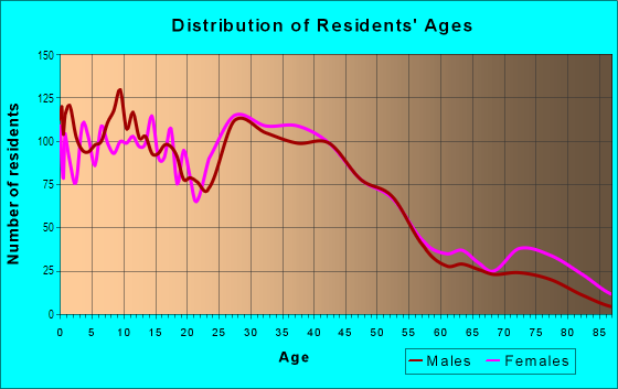
| Males: | 7,308 |
| Females: | 6,079 |
Males:
| This neighborhood: | 36.8 years |
| Whole city: | 35.4 years |
| This neighborhood: | 32.7 years |
| Whole city: | 38.2 years |
Average household size:
| Woodsdale: | 2.3 people |
| Toledo: | 2.1 people |
Percentage of family households:
| Woodsdale: | 55.3% |
| Toledo: | 37.8% |
| Here: | 32.4% |
| Toledo: | 29.6% |
Percentage of married-couple families with children (among all households):
| Woodsdale: | 17.4% |
| Toledo: | 19.6% |
Percentage of single-mother households (among all households):
| Woodsdale: | 16.0% |
| Toledo: | 21.5% |
Percentage of never married males 15 years old and over:
Percentage of never married females 15 years old and over:
| Woodsdale: | 21.2% |
| Toledo: | 22.1% |
Percentage of never married females 15 years old and over:
| Woodsdale: | 19.3% |
| city: | 21.2% |
Percentage of people that speak English not well or not at all:
| Woodsdale: | 0.0% |
| Toledo: | 0.7% |
Percentage of people born in this state:
Percentage of people born in another U.S. state:
Percentage of native residents but born outside the U.S.:
Percentage of foreign born residents:
| Here: | 79.1% |
| Toledo: | 76.6% |
Percentage of people born in another U.S. state:
| Woodsdale: | 18.3% |
| Toledo: | 19.3% |
Percentage of native residents but born outside the U.S.:
| Here: | 0.4% |
| city: | 0.6% |
Percentage of foreign born residents:
| Here: | 2.4% |
| Toledo: | 3.6% |

Owner-occupied
Renter-occupied


- Rooms in owner-occupied houses and condos in Woodsdale
- 01 room
- 02 rooms
- 403 rooms
- 1384 rooms
- 3565 rooms
- 4546 rooms
- 9827 rooms
- 7578 rooms
- 1,7999+ rooms

- Rooms in renter-occupied apartments in Woodsdale
- 3241 room
- 2502 rooms
- 3923 rooms
- 4604 rooms
- 5815 rooms
- 6316 rooms
- 4957 rooms
- 968 rooms
- 09+ rooms
Owner-occupied
Renter-occupied

- Bedrooms in owner-occupied houses and condos in Woodsdale
- 0no bedroom
- 641 bedroom
- 3702 bedrooms
- 2,1113 bedrooms
- 1,3904 bedrooms
- 3625+ bedrooms

- Bedrooms in renter-occupied apartments in Woodsdale
- 217no bedroom
- 6251 bedroom
- 6912 bedrooms
- 8783 bedrooms
- 744 bedrooms
- 1295+ bedrooms
Average number of cars or other vehicles available in houses/condos:
Average number of cars or other vehicles available in apartments:
| This neighborhood: | 1.9 |
| Toledo: | 1.8 |
Average number of cars or other vehicles available in apartments:
| Here: | |
| city: |
Percentage of units with a mortgage:
| Woodsdale: | 59.1% |
| Toledo: | 54.5% |
Average estimated value of detached houses in 2022 (76.4% of all units):
| Woodsdale: | $77,696 |
| Toledo: | $131,824 |

- Year house built in Woodsdale
- 02020 or later
- 1852010 to 2019
- 202000 to 2009
- 2071990 to 1999
- 1971980 to 1989
- 3491970 to 1979
- 1831960 to 1969
- 7721950 to 1959
- 8471940 to 1949
- 4,5291939 or earlier

City-data.com crime index for city in 2020 (higher means more crime):
| City: | 452.0 |
| U.S. average: | 219.5 |
Travel time to work (commute)
![Travel time to work (commute)]()
- 100Less than 5 minutes
- 3365 to 9 minutes
- 29510 to 14 minutes
- 84315 to 19 minutes
- 49020 to 24 minutes
- 10225 to 29 minutes
- 19230 to 34 minutes
- 2835 to 39 minutes
- 8040 to 44 minutes
- 10845 to 59 minutes
- 33260 to 89 minutes
- 3490 or more minutes

Means of transportation to work
![Means of transportation to work]()
- 84.0%5,159Drove a car alone
- 9.1%562Carpooled
- 2.4%148Bus
- 5.8%356Taxi
- 3.8%231Bicycle
- 3.2%195Walked
- 1.1%70Other means
- 6.8%420Worked at home

Time leaving home to go to work
![Time leaving home to go to work]()
- 28612:00 a.m. to 4:59 a.m.
- 1485:00 a.m. to 5:29 a.m.
- 695:30 a.m. to 5:59 a.m.
- 3056:00 a.m. to 6:29 a.m.
- 1486:30 a.m. to 6:59 a.m.
- 3237:00 a.m. to 7:29 a.m.
- 3277:30 a.m. to 7:59 a.m.
- 3148:00 a.m. to 8:29 a.m.
- 818:30 a.m. to 8:59 a.m.
- 1089:00 a.m. to 9:59 a.m.
- 9710:00 a.m. to 10:59 a.m.
- 12711:00 a.m. to 11:59 a.m.
- 38912:00 p.m. to 3:59 p.m.
- 3284:00 p.m. to 11:59 p.m.

Occupations of males:
- Percentage of males in management occupations (except farmers):
Here: 4.1% city: 6.4%
- Percentage of males in business and financial operations occupations:
Here: 1.3% city: 3.0%
- Percentage of males in computer and mathematical occupations:
Here: 3.2% city: 2.3%
- Percentage of males in life, physical, and social science occupations:
Here: 1.2% city: 0.5%
- Percentage of males in education, training, and library occupations:
Here: 3.7% city: 2.6%
- Percentage of males in arts, design, entertainment, sports, and media occupations:
Here: 2.9% city: 1.6%
- Percentage of males in healthcare practitioners and technical occupations:
Here: 3.7% city: 2.0%
- Percentage of males in service occupations:
Here: 7.0% city: 16.4%
- Percentage of males in sales and office occupations:
Here: 17.4% city: 14.8%
- Percentage of males in construction, extraction, and maintenance occupations:
Here: 5.2% city: 7.8%
- Percentage of males in production occupations:
Here: 3.7% city: 14.7%
- Percentage of males in transportation occupations:
Here: 25.3% city: 7.7%
- Percentage of males in material moving occupations:
Here: 16.1% city: 10.7%
Occupations of females:
- Percentage of females in management occupations (except farmers):
Here: 11.0% city: 7.4%
- Percentage of females in business and financial operations occupations:
Here: 2.9% city: 4.1%
- Percentage of females in community and social services occupations:
Here: 6.6% city: 2.8%
- Percentage of females in education, training, and library occupations:
Here: 2.1% city: 7.0%
- Percentage of females in healthcare practitioners and technical occupations:
Here: 13.4% city: 9.7%
- Percentage of females in service occupations:
Here: 32.8% city: 24.8%
- Percentage of females in sales and office occupations:
Here: 24.3% city: 27.5%
- Percentage of females in production occupations:
Here: 1.3% city: 7.0%
- Percentage of females in material moving occupations:
Here: 3.1% city: 3.9%
Percentage of people 16-64 in Armed Forces:
| Woodsdale: | 0.0% |
| Toledo: | 0.2% |
Education in this neighborhood (subdivision or community):
- Percentage of people 3 years and older in K-12 schools:
Woodsdale: 22.4% Toledo: 16.7%
- Percentage of people 3 years and older in undergraduate colleges:
Woodsdale: 5.8% Toledo: 6.1%
- Percentage of people 3 years and older in grad. or professional schools:
Woodsdale: 5.5% Toledo: 1.7%
- Percentage of students K-12 enrolled in private schools:
Woodsdale: 34.0% Toledo: 21.4%
Percentage of population below poverty level:
| Woodsdale: | 17.7% |
| Toledo: | 23.3% |
Median year owner moved in (as recorded in 2022):
| Woodsdale: | 2002 |
| Toledo: | 2008 |
Percentage of married-couple families with both working:
| Woodsdale: | 64.4% |
| Toledo: | 69.3% |

- 76.7%Utility gas
- 6.2%Electricity
- 6.0%No fuel used
- 5.5%Wood
- 3.1%Bottled, tank, or LP gas
- 1.7%Fuel oil, kerosene, etc.
- 1.0%Other fuel
Highways in this neighborhood:
State Rte 25 (Anthony Wayne Trl)
Length: 5.56 miles
Direction: SW-NE
Direction: SW-NE
S Detroit Ave (US Hwy 24)
Length: 1.73 miles
Direction: SW-NE
Address range: 300 to 1499
Direction: SW-NE
Address range: 300 to 1499
State Rte 2 (Western Ave)
Length: 1.65 miles
Direction: E-W
Address range: 860 to 1699
Direction: E-W
Address range: 860 to 1699
State Rte 2 (Airport Hwy)
Length: 0.54 miles
Directions: E-W, SW-NE
Address range: 1700 to 1999
Directions: E-W, SW-NE
Address range: 1700 to 1999
Roads and streets:
Spencer St
Length: 1.83 miles
Directions: E-W, N-S, SE-NW, SW-NE
Address range: 300 to 1899
Directions: E-W, N-S, SE-NW, SW-NE
Address range: 300 to 1899
South Ave
Length: 1.81 miles
Direction: E-W
Address range: 1017 to 1999
Direction: E-W
Address range: 1017 to 1999
Broadway St
Length: 1.40 miles
Direction: SW-NE
Address range: 2323 to 2999
Direction: SW-NE
Address range: 2323 to 2999
Prouty Ave
Length: 1.29 miles
Directions: E-W, N-S
Address range: 1200 to 1899
Directions: E-W, N-S
Address range: 1200 to 1899
Glendale Ave
Length: 1.28 miles
Directions: E-W, SE-NW, SW-NE
Address range: 1800 to 2499
Directions: E-W, SE-NW, SW-NE
Address range: 1800 to 2499
Arlington Ave
Length: 1.06 miles
Direction: E-W
Address range: 1600 to 2199
Direction: E-W
Address range: 1600 to 2199
Walbridge Ave
Length: 0.97 miles
Direction: E-W
Address range: 1000 to 1600
Direction: E-W
Address range: 1000 to 1600
Woodsdale Ave
Length: 0.94 miles
Direction: N-S
Address range: 500 to 1189
Direction: N-S
Address range: 500 to 1189
Nelson Ave
Length: 0.86 miles
Direction: E-W
Address range: 1530 to 2029
Direction: E-W
Address range: 1530 to 2029
Colton St
Length: 0.82 miles
Direction: E-W
Address range: 1100 to 1699
Direction: E-W
Address range: 1100 to 1699
Gordon St
Length: 0.72 miles
Direction: E-W
Address range: 900 to 1399
Direction: E-W
Address range: 900 to 1399
Toronto Ave
Length: 0.66 miles
Directions: N-S, SE-NW
Address range: 500 to 1099
Directions: N-S, SE-NW
Address range: 500 to 1099
Geneva Ave
Length: 0.65 miles
Directions: N-S, SE-NW
Address range: 500 to 999
Directions: N-S, SE-NW
Address range: 500 to 999
Princeton Dr
Length: 0.64 miles
Directions: E-W, N-S, SE-NW, SW-NE
Address range: 1 to 1999
Directions: E-W, N-S, SE-NW, SW-NE
Address range: 1 to 1999
Wright Ave
Length: 0.63 miles
Direction: N-S
Address range: 600 to 1099
Direction: N-S
Address range: 600 to 1099
Grafton Ave
Length: 0.60 miles
Direction: E-W
Address range: 1500 to 1799
Direction: E-W
Address range: 1500 to 1799
Ogden Ave
Length: 0.59 miles
Directions: N-S, SE-NW
Address range: 500 to 999
Directions: N-S, SE-NW
Address range: 500 to 999
Colburn St
Length: 0.57 miles
Direction: E-W
Address range: 1200 to 1499
Direction: E-W
Address range: 1200 to 1499
Hampton Ave
Length: 0.56 miles
Directions: N-S, SE-NW
Address range: 500 to 999
Directions: N-S, SE-NW
Address range: 500 to 999
Patrick Rafter Blvd
Length: 0.56 miles
Directions: E-W, N-S, SE-NW, SW-NE
Directions: E-W, N-S, SE-NW, SW-NE
Marlboro St
Length: 0.52 miles
Directions: E-W, SW-NE
Address range: 2500 to 2799
Directions: E-W, SW-NE
Address range: 2500 to 2799
Brighton Ave
Length: 0.51 miles
Direction: N-S
Address range: 500 to 899
Direction: N-S
Address range: 500 to 899
Shasta Dr
Length: 0.47 miles
Directions: N-S, SE-NW, SW-NE
Address range: 300 to 699
Directions: N-S, SE-NW, SW-NE
Address range: 300 to 699
Francis Ave
Length: 0.46 miles
Direction: N-S
Address range: 900 to 1099
Direction: N-S
Address range: 900 to 1099
Atlantic Ave
Length: 0.45 miles
Direction: N-S
Address range: 800 to 1099
Direction: N-S
Address range: 800 to 1099
Wilton St
Length: 0.45 miles
Direction: E-W
Address range: 1700 to 2029
Direction: E-W
Address range: 1700 to 2029
Glenview Rd
Length: 0.44 miles
Directions: E-W, N-S, SE-NW, SW-NE
Address range: 1200 to 1439
Directions: E-W, N-S, SE-NW, SW-NE
Address range: 1200 to 1439
Aberdeen Ave
Length: 0.44 miles
Direction: E-W
Address range: 2124 to 2499
Direction: E-W
Address range: 2124 to 2499
Nieson Blvd
Length: 0.43 miles
Directions: E-W, N-S, SE-NW, SW-NE
Directions: E-W, N-S, SE-NW, SW-NE
Lodge Ave
Length: 0.43 miles
Directions: N-S, SE-NW
Address range: 500 to 899
Directions: N-S, SE-NW
Address range: 500 to 899
National Ave
Length: 0.43 miles
Direction: N-S
Address range: 800 to 1099
Direction: N-S
Address range: 800 to 1099
Daniels Ave
Length: 0.42 miles
Direction: N-S
Address range: 300 to 699
Direction: N-S
Address range: 300 to 699
Garden Lake Dr
Length: 0.41 miles
Directions: E-W, N-S, SE-NW, SW-NE
Address range: 2043 to 2199
Directions: E-W, N-S, SE-NW, SW-NE
Address range: 2043 to 2199
Hiett Ave
Length: 0.39 miles
Direction: N-S
Address range: 300 to 599
Direction: N-S
Address range: 300 to 599
Nicholas St
Length: 0.36 miles
Directions: N-S, SE-NW
Address range: 500 to 1537
Directions: N-S, SE-NW
Address range: 500 to 1537
Amherst Dr
Length: 0.36 miles
Directions: E-W, N-S
Address range: 100 to 399
Directions: E-W, N-S
Address range: 100 to 399
Harvard Blvd
Length: 0.35 miles
Direction: N-S
Address range: 1200 to 1499
Direction: N-S
Address range: 1200 to 1499
Wildwood Rd
Length: 0.34 miles
Directions: N-S, SW-NE
Address range: 1200 to 1498
Directions: N-S, SW-NE
Address range: 1200 to 1498
Foraker Ave
Length: 0.31 miles
Direction: E-W
Address range: 2500 to 2699
Direction: E-W
Address range: 2500 to 2699
University Blvd
Length: 0.31 miles
Directions: E-W, SE-NW
Address range: 100 to 299
Directions: E-W, SE-NW
Address range: 100 to 299
Griffin St
Length: 0.30 miles
Direction: SW-NE
Address range: 900 to 1199
Direction: SW-NE
Address range: 900 to 1199
Glencove Dr
Length: 0.30 miles
Direction: E-W
Address range: 1900 to 2099
Direction: E-W
Address range: 1900 to 2099
Finch St
Length: 0.30 miles
Directions: N-S, SW-NE
Address range: 1700 to 1899
Directions: N-S, SW-NE
Address range: 1700 to 1899
Carlton St
Length: 0.30 miles
Directions: N-S, SE-NW
Address range: 500 to 799
Directions: N-S, SE-NW
Address range: 500 to 799
Champion St
Length: 0.30 miles
Direction: N-S
Address range: 300 to 499
Direction: N-S
Address range: 300 to 499
Dartmouth Dr
Length: 0.29 miles
Directions: E-W, SW-NE
Address range: 100 to 299
Directions: E-W, SW-NE
Address range: 100 to 299
Southmoor Dr
Length: 0.27 miles
Direction: E-W
Address range: 1900 to 2099
Direction: E-W
Address range: 1900 to 2099
S Hawley St
Length: 0.27 miles
Direction: N-S
Address range: 300 to 499
Direction: N-S
Address range: 300 to 499
Peabody Ave
Length: 0.27 miles
Direction: E-W
Address range: 2200 to 2399
Direction: E-W
Address range: 2200 to 2399
Shadowlawn Dr
Length: 0.25 miles
Direction: N-S
Address range: 1000 to 1199
Direction: N-S
Address range: 1000 to 1199
Almon Ave
Length: 0.24 miles
Direction: N-S
Address range: 1300 to 1499
Direction: N-S
Address range: 1300 to 1499
Mound Ave
Length: 0.24 miles
Direction: N-S
Address range: 1300 to 1499
Direction: N-S
Address range: 1300 to 1499
Abbott Ave
Length: 0.24 miles
Direction: N-S
Address range: 1300 to 1499
Direction: N-S
Address range: 1300 to 1499
Corry Ave
Length: 0.24 miles
Direction: N-S
Address range: 1300 to 1499
Direction: N-S
Address range: 1300 to 1499
Laurel Ave
Length: 0.24 miles
Direction: N-S
Address range: 1300 to 1499
Direction: N-S
Address range: 1300 to 1499
Dale St
Length: 0.22 miles
Direction: N-S
Address range: 300 to 499
Direction: N-S
Address range: 300 to 499
Ratcliffe Dr
Length: 0.22 miles
Direction: N-S
Address range: 1000 to 1199
Direction: N-S
Address range: 1000 to 1199
Heatherdale Dr
Length: 0.22 miles
Directions: E-W, SE-NW
Address range: 1900 to 2099
Directions: E-W, SE-NW
Address range: 1900 to 2099
Opal St
Length: 0.20 miles
Directions: E-W, SW-NE
Address range: 1200 to 1399
Directions: E-W, SW-NE
Address range: 1200 to 1399
N Kennison Dr
Length: 0.20 miles
Directions: E-W, N-S, SE-NW, SW-NE
Address range: 2000 to 2099
Directions: E-W, N-S, SE-NW, SW-NE
Address range: 2000 to 2099
Garden Lake Pkwy
Length: 0.19 miles
Directions: E-W, SW-NE
Address range: 900 to 1099
Directions: E-W, SW-NE
Address range: 900 to 1099
Bonfield Dr
Length: 0.19 miles
Directions: E-W, N-S
Address range: 1800 to 2029
Directions: E-W, N-S
Address range: 1800 to 2029
Larc Ln
Length: 0.19 miles
Directions: N-S, SW-NE
Address range: 1100 to 1299
Directions: N-S, SW-NE
Address range: 1100 to 1299
S Kennison Dr
Length: 0.18 miles
Directions: E-W, SW-NE
Address range: 2000 to 2099
Directions: E-W, SW-NE
Address range: 2000 to 2099
Toledo Ave
Length: 0.17 miles
Directions: N-S, SE-NW
Address range: 700 to 899
Directions: N-S, SE-NW
Address range: 700 to 899
Beecham St
Length: 0.17 miles
Direction: SW-NE
Address range: 1400 to 1499
Direction: SW-NE
Address range: 1400 to 1499
Kenyon Dr
Length: 0.17 miles
Directions: N-S, SE-NW
Address range: 1300 to 1499
Directions: N-S, SE-NW
Address range: 1300 to 1499
Wylie Ave
Length: 0.17 miles
Direction: N-S
Address range: 800 to 899
Direction: N-S
Address range: 800 to 899
Ingomar Ave
Length: 0.17 miles
Direction: E-W
Address range: 1400 to 1499
Direction: E-W
Address range: 1400 to 1499
Canal Ave
Length: 0.17 miles
Direction: SW-NE
Address range: 301 to 399
Direction: SW-NE
Address range: 301 to 399
Yale Dr
Length: 0.17 miles
Directions: E-W, SE-NW
Address range: 100 to 199
Directions: E-W, SE-NW
Address range: 100 to 199
Cornell Dr
Length: 0.17 miles
Directions: E-W, SW-NE
Address range: 100 to 199
Directions: E-W, SW-NE
Address range: 100 to 199
Bow St
Length: 0.16 miles
Direction: E-W
Address range: 1500 to 1699
Direction: E-W
Address range: 1500 to 1699
Lomond Dr
Length: 0.16 miles
Direction: N-S
Address range: 500 to 799
Direction: N-S
Address range: 500 to 799
Cummings Ave
Length: 0.16 miles
Direction: E-W
Address range: 2000 to 2199
Direction: E-W
Address range: 2000 to 2199
Zale Pl
Length: 0.15 miles
Direction: SE-NW
Address range: 1300 to 1499
Direction: SE-NW
Address range: 1300 to 1499
Wendell St
Length: 0.14 miles
Direction: N-S
Address range: 400 to 499
Direction: N-S
Address range: 400 to 499
S Miller St
Length: 0.14 miles
Direction: N-S
Address range: 300 to 399
Direction: N-S
Address range: 300 to 399
Emery St
Length: 0.14 miles
Directions: N-S, SE-NW
Address range: 200 to 299
Directions: N-S, SE-NW
Address range: 200 to 299
Hedge Ln
Length: 0.13 miles
Directions: E-W, N-S
Address range: 1500 to 1899
Directions: E-W, N-S
Address range: 1500 to 1899
Vassar Dr
Length: 0.12 miles
Directions: N-S, SE-NW
Address range: 1400 to 1499
Directions: N-S, SE-NW
Address range: 1400 to 1499
Southcrest St
Length: 0.11 miles
Directions: N-S, SE-NW
Address range: 100 to 499
Directions: N-S, SE-NW
Address range: 100 to 499
St James Ct
Length: 0.11 miles
Direction: N-S
Address range: 1000 to 1099
Direction: N-S
Address range: 1000 to 1099
Edna St
Length: 0.11 miles
Direction: N-S
Address range: 300 to 399
Direction: N-S
Address range: 300 to 399
Eldred Ave
Length: 0.10 miles
Direction: N-S
Address range: 300 to 399
Direction: N-S
Address range: 300 to 399
Lynhaven Dr
Length: 0.09 miles
Direction: N-S
Address range: 500 to 599
Direction: N-S
Address range: 500 to 599
Storrs St
Length: 0.09 miles
Direction: N-S
Address range: 200 to 299
Direction: N-S
Address range: 200 to 299
Salem St
Length: 0.08 miles
Direction: SE-NW
Address range: 1000 to 1099
Direction: SE-NW
Address range: 1000 to 1099
Garden Lake Blvd
Length: 0.08 miles
Direction: E-W
Address range: 953 to 957
Direction: E-W
Address range: 953 to 957
Myers St
Length: 0.08 miles
Directions: E-W, N-S, SE-NW
Address range: 600 to 699
Directions: E-W, N-S, SE-NW
Address range: 600 to 699
S Fearing Blvd
Length: 0.08 miles
Direction: E-W
Address range: 1900 to 1999
Direction: E-W
Address range: 1900 to 1999
Blake Pl
Length: 0.07 miles
Direction: SE-NW
Address range: 1300 to 1399
Direction: SE-NW
Address range: 1300 to 1399
Garden Lake Pl
Length: 0.07 miles
Directions: E-W, SE-NW, SW-NE
Directions: E-W, SE-NW, SW-NE
Emma St
Length: 0.06 miles
Direction: E-W
Address range: 1500 to 1599
Direction: E-W
Address range: 1500 to 1599
Alden Ct
Length: 0.06 miles
Direction: SE-NW
Address range: 1000 to 1099
Direction: SE-NW
Address range: 1000 to 1099
Gilbert Rd
Length: 0.04 miles
Direction: SW-NE
Address range: 1500 to 1599
Direction: SW-NE
Address range: 1500 to 1599
Wayne St
Length: 0.04 miles
Direction: E-W
Address range: 1619 to 1699
Direction: E-W
Address range: 1619 to 1699
Garden Lake Ct
Length: 0.04 miles
Direction: N-S
Direction: N-S
Yosemite Dr
Length: 0.03 miles
Direction: SE-NW
Address range: 1600 to 1614
Direction: SE-NW
Address range: 1600 to 1614
Mozart St
Length: 0.03 miles
Direction: N-S
Address range: 300 to 399
Direction: N-S
Address range: 300 to 399
Railroad features:
New York Chicago and St Louis RR
Length: 4.23 miles
Directions: E-W, N-S, SE-NW, SW-NE
Directions: E-W, N-S, SE-NW, SW-NE
Wabash RR
Length: 0.40 miles
Directions: N-S, SW-NE
Directions: N-S, SW-NE
Other features:
Swan Crk
Length: 1.83 miles
Directions: E-W, N-S, SE-NW, SW-NE
Directions: E-W, N-S, SE-NW, SW-NE